
Crooked Creek Fire Fact Sheet June 22 2021 at 8 PM
Related Incident:
Publication Type: News
Crooked Creek FireTuesday, June 22, 2021 at 8:00PM
Inciweb: https://inciweb.nwcg.gov/incident/7542/
Email: 2021.crookedcreek@firenet.govFacebook: https://www.facebook.com/custergallatin/
Public Information Phone: (406) 290-3559https://www.facebook.com/BLMMontana/
Location: 25 miles east of Bridger, MontanaIncident Command: Type 2 Northern Rockies Incident Management Team 4, Brian Jenkins – Incident Commander
Size: 5,400 acres Containment: 0% Personnel: 231
Overview: The Crooked Creek Fire is located near the southern border of the Crow Indian Reservation in the Pryor Mountains on the Custer Gallatin National Forest. Fire Information for both the Robertson Draw Fire and Crooked Creek Fire is being staffed at the Incident Command Post (ICP) in Belfry, MT. The public information phone number listed above will answer for both fires.
Current Status: Fire crews continued work on protecting structures, historical resources, the Dryhead Creek watershed, and high voltage powerlines through direct and indirect fire line methods. Direct line is working alongside the fire’s edge and indirect line is a containment line constructed by hand or equipment to stop fire spread and located out ahead of the fire activity. On the south side of the fire crews continued to patrol the fire’s edge and mop up any hot spots that were found. On the east side several hotshot crews continued to work on direct containment hand line construction. The heavy equipment task force was positioned to begin working along the road system through the timbered areas on the northwest side of the fire. Firefighters continued to monitor for any threat to the Pryor Mountain Wild Horse Range, which is southeast of the fire. The fire is not currently impacting the wild horse herd.
Planned Actions: The heavy equipment task force which consists of fellers, bunchers, and skidders equipment will continue to construct a fuel break fire line along the northwest side of the fire. On the east side crews will continue to prepare a containment line and will go direct along the fire’s edge where safe to do so. Along the south side crews will once again patrol and mop up hot spots. Aerial water drops with fixed wing airplanes and helicopters will be used as needed. The Unmanned Aircraft System (UAS) flight was delayed today so it will be rescheduled for tomorrow. The UAS will be used to conduct a more detailed and accurate mapping flight over the fire area. It is expected that the fire size could change after this flight.
Pre-Evacuation Warning: The Carbon County Sheriff’s Office has issued a pre-evacuation warning notice for twenty-five primary residences in the Sage Creek area.
Closures: All the Custer Gallatin National Forest lands northeast of Forest Road 2308 and east of Forest Road 2085 are under a Forest Closure Order and temporarily closed to public use. All BLM lands in the north Pryor Mountains within Township 8 South, Range 28 East and the entirety of Sykes Ridge Road in Carbon County, Montana are also under a BLM Closure Order and temporarily closed to public use.
Temporary Flight Restrictions (TFR): A TFR is in place for air space over the Crooked Creek Fire (FDC 1/7699) to provide a safe environment for firefighting aircraft operating in the area. Remember that temporary flight restrictions also apply to unmanned aircraft systems (UAS) or drones. If you fly, we can’t!
Primary and Cooperating Agencies: USFS, BLM, BIA-Crow Agency, Carbon County Sheriff’s Office, DES, Bighorn County Sheriff’s Office, NPS-Bighorn Canyon National Recreation Area
Crooked Creek Fire Fact Sheet June 21 800 pm
Related Incident:
Publication Type: News
Crooked Creek FireMonday, June 21, 2021 at 8:00PM
Inciweb: https://inciweb.nwcg.gov/incident/7542/ Email: 2021.crookedcreek@firenet.govFacebook: https://www.facebook.com/custergallatin/ Public Information Phone: (406) 290-3559https://www.facebook.com/BLMMontana/
Location: 25 miles east of Bridger, MontanaIncident Command: Type 2 Northern Rockies Incident Management Team 4, Brian Jenkins – Incident Commander
Size: 5,400 acres Containment: 0% Personnel: 241
Description: The Crooked Creek Fire is located near the southern border of the Crow Indian Reservation in the Prior Mountains on the Custer Gallatin National Forest.
Current Status: At 6:00 am on June 21, 2021 Northern Rockies Team 4 assumed command of the Crooked Creek Fire from the local unit. NR Team 4 is also managing the Robertson Draw Fire south of Red Lodge, Montana and has an Incident Command Post (ICP) established at the Belfry School in Belfry, MT. Team 4 Operations personnel have been quickly increasing their situational awareness on this fire and logistics has been increasing the support efforts needed for the firefighters that have been working on the fire for several days. An adjustment to containment percentage was made today as the fire line areas were reassessed.
Today, fire crews continued their work to protect high voltage powerlines, historical resources and the Dryhead Creek watershed by scouting and working on indirect fire lines. Indirect fire line is a containment line constructed by hand or equipment to stop fire spread and located out ahead of the fire activity in its potential direction of movement. The fire area has been divided into three areas for operations, south, east, and northwest for when we describe specific fire suppression actions that are being completed. Firefighters will continue to monitor any threat to the Pryor Mountain Wild Horse Range, which is southeast of the fire and is not currently impacting the wild horse herd.
Planned Actions: On the northwest and east sides of the fire crews will continue to scout and prepare indirect fire lines and go direct along the fire’s edge where safe to do so. There are seven crews working on fire line along the eastern side of the fire. A heavy equipment task force which consists of fellers, bunchers, and skidders equipment will be used to start constructing a fuel break fire line through the heavy timbered area on the south side of the fire. Aerial water drops with fixed wing airplanes and helicopters will be used as needed. Air operations also ordered an Unmanned Aircraft System which will be used to conduct a more detailed and accurate mapping flight over the fire area. It is expected that the fire size could change by tomorrow evening.
Fire Information for both the Robertson Draw Fire and Crooked Creek Fire is being staffed at the ICP in Belfry, MT. The public information phone number listed above will answer for both fires.
Pre-Evacuation Warning: The Carbon County Sheriff’s Office has issued a pre-evacuation warning notice for twenty-five primary residences in the Sage Creek area.
Closures: All the Custer Gallatin National Forest lands northeast of Forest Road 2308 and east of Forest Road 2085 are under a Forest Closure Order and temporarily closed to public use. All BLM lands in the north Pryor Mountains within Township 8 South, Range 28 East and the entirety of Sykes Ridge Road in Carbon County, Montana are also under a BLM Closure Order and temporarily closed to public use.
Temporary Flight Restrictions (TFR): A new TFR is in place for air space over the Crooked Creek Fire (FDC 1/7699) to provide a safe environment for firefighting aircraft operating in the area. Remember that temporary flight restrictions also apply to unmanned aircraft systems (UAS) or drones. If you fly, we can’t!
Primary and Cooperating Agencies: USFS, BLM, BIA-Crow Agency, Carbon County Sheriff’s Office, DES, Bighorn County Sheriff’s Office, NPS-Bighorn Canyon National Recreation Area
Crooked Creek Fire Update June 20 2021 630 pm
Related Incident:
Publication Type: News
CROOKED CREEK FIRE UPDATE
June 20, 2021 – 6:30 p.m.
Contact: Al Nash, 406.896.5260, al_nash@blm.gov
Reported: June 15, 2021, at 7:00 p.m.
Cause: Unknown
Size: 5,400 acres, 20% containment
The Crooked Creek Fire is located 25 miles east of Bridger, Mont., in the Pryor Mountains. It located in Carbon County near the southern boundary of the Crow Indian Reservation on the Custer Gallatin National Forest.
The cooler temperatures, light rainfall and higher humidity experienced across South Central Montana on Sunday resulted in minimal fire activity. The fire remains at 5,400 acres with 20-percent containment. One outbuilding was destroyed on Saturday. There are now 221 personnel assigned to the Crooked Creek Fire.
Management of the Crooked Creek Fire will transition Monday morning from the current local Type 3 organization to Northern Rockies Type 2 Incident Management Team #4, which is managing the nearby Robertson Draw Fire.
Sunday’s respite from the hot and dry weather will be short lived. Rain showers in the area will end Sunday evening, with temperatures increasing significantly on Monday. A return to well above normal temperatures and dry conditions is forecast for the region by mid-week.
Public lands managed by the Custer Gallatin National Forest and the Bureau of Land Management near the fire have been temporarily closed due to public safety concerns. A pre-evacuation warning notice issued by the Carbon County Sheriff’s Office for twenty-five primary residences in the Sage Creek area remains in effect. The Crooked Creek Fire perimeter is well northwest of the Pryor Mountain Wild Horse Range and is not impacting the wild horse herd.
For more information please visit InciWeb at https://inciweb.nwcg.gov/incident/7542/ or visit us on Facebook at https://www.facebook.com/BLMMontana/ or follow us on Twitter at @BLM_MTDKs.
– BLM –
Crooked Creek Fire Update June 19 2021 700 pm
Related Incident:
Publication Type: News
CROOKED CREEK FIRE UPDATE
June 19, 2021 – 7:00 p.m.
Contact: Al Nash, 406.896.5260, al_nash@blm.gov
Reported: June 15, 2021, at 7:00 p.m.
Cause: Unknown
Size: 5,400 acres, 20% containment
The Crooked Creek Fire is on National Forest System lands in the Pryor Mountains in south central Montana. It is in Carbon County near the southern border of the Crow Indian Reservation, 25 miles east of the town of Bridger.
Despite hot, dry, and windy conditions and active fire behavior, the fire grew eastward just 200 acres on Saturday. One outbuilding was destroyed. More importantly, containment doubled in the past 24 hours to 20-percent. There are now a total of 131 personnel assigned to the Crooked Creek Fire.
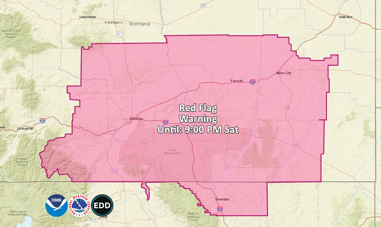
A Red Flag Warning remains in effect until 9:00 pm Saturday for south central and southeastern Montana including the Crooked Creek Fire area. An incoming cold front is forecast to bring some rain over the fire beginning Sunday morning and persisting into the afternoon, along with a brief cool down. Hot and dry conditions are forecast to return by mid-week.
Sunday, firefighters plan to continue point protection of critical infrastructure, build additional fire line, and reinforce fire line already constructed.
A pre-evacuation warning notice for twenty-five primary residences in the Sage Creek area previously issued by the Carbon County Sheriff’s Office remains in effect. Public lands managed by the Custer Gallatin National Forest and the Bureau of Land Management near the fire have been temporarily closed due to public safety concerns. The fire remains well northwest of the Pryor Mountain Wild Horse Range.
For more information please visit InciWeb at https://inciweb.nwcg.gov/incident/7542/ or visit us on Facebook at https://www.facebook.com/BLMMontana/ or follow us on Twitter at @BLM_MTDKs.
– BLM –
Crooked Creek Fire Update June 18 2021 700 pm
Related Incident:
Publication Type: News
CROOKED CREEK FIRE UPDATE
June 18, 2021 – 7:00 p.m.
Contact: Al Nash, 406.896.5260, al_nash@blm.gov
Reported: June 15, 2021, at 7:00 p.m.
Cause: Unknown
Size: 5,200 acres, 10% containment
The Crooked Creek Fire is burning 25 miles east of the town of Bridger in Carbon County. Mont. The fire is located near the southern border of the Crow Indian Reservation in the Pryor Mountains on the Custer Gallatin National Forest.
The fire is now estimated at 5,200 acres, just a 100 acre increase since Thursday evening. With the addition of more resources including another firefighting helicopter and another 20-person Type 2 Initial Attack hand crew, firefighters were able to build containment line along 10 percent of the fire perimeter on Friday.
The Billings Airtanker Base remains very, busy supporting multiple aircraft that are dropping retardant or water on the four large fires burning in South Central Montana.
National Forest System and Bureau of Land Management public lands near the fire have been temporarily closed due to public safety concerns. The Carbon County Sheriff’s Office has continued the pre-evacuation warning notice for twenty-five primary residences in the Sage Creek area. Firefighters are also working to protect high voltage powerlines, historical resources and the Dryhead Creek watershed. They’re also keeping an eye on any threat to the Pryor Mountain Wild Horse Range, which is southeast of the fire and is not currently impacting the wild horse herd.
The National Weather Service in Billings has issued a Red Flag Warning from Noon to 9:00 pm Saturday for South Central and Southeast Montana including the area of the Crooked Creek fire due to forecast hotter and drier conditions and increasing winds ahead of an incoming cold front. The good news is that there is chance of rain showers beginning Saturday night, with cooler conditions expected Sunday.
For more information please visit InciWeb at https://inciweb.nwcg.gov/incident/7542/ or visit us on Facebook at https://www.facebook.com/BLMMontana/ or follow us on Twitter at @BLM_MTDKs.
– BLM –
Red Flag WARNING for Saturday June 19
Related Incident:
Publication Type: Announcement
URGENT - FIRE WEATHER MESSAGE
National Weather Service Billings MT
200 PM MDT Fri Jun 18 2021
MTZ125>132-WYZ274-192000-
/O.UPG.KBYZ.FW.A.0004.210619T1800Z-210620T0300Z/
/O.NEW.KBYZ.FW.W.0006.210619T1800Z-210620T0300Z/
Stillwater County-Beartooth Ranger District Custer National Forest-
Golden Valley County/Musselshell county-Yellowstone County-
Crow Indian Reservation/Bighorn Canyon Rec Area-
Northern Rosebud/Northern Treasure Counties-
Northern Cheyenne Indian Reservation/Ashland Ranger District
Custer Natl Forest-Custer County-Sheridan County-
200 PM MDT Fri Jun 18 2021
...RED FLAG WARNING IN EFFECT FROM NOON TO 9 PM MDT SATURDAY...
The National Weather Service in Billings has issued a Red Flag
Warning...which is in effect from noon to 9 PM MDT Saturday. The
Fire Weather Watch is no longer in effect.
* IMPACTS: Low humidities, unseasonably warm temperatures, strong
gusty winds, and wind shift with a cold front will create
erratic fire behavior and new fire starts.
* AFFECTED AREA: In North Central WY Fire Zone...274.
In South Central MT Fire Zones...125...126...127...128...129.
In Southeast MT Fire Zones...130...131...132.
* COUNTIES AFFECTED: In Central MT...Golden Valley...Musselshell.
In North Central WY...Sheridan.
In South Central MT...Big Horn...Carbon...Park...Stillwater
Sweet Grass...Yellowstone.
In Southeast MT...Custer...Powder River...Rosebud...Treasure.
* WIND: Northwest 15 to 25 mph with gusts 30 to 35 mph. Winds
becoming north to northeast by Saturday evening.
* HUMIDITY: 14 to 19 percent.
* TEMPERATURES: Highs in the mid 80s to lower 90s.
* COLD FRONT: Saturday evening, turning winds to the northeast.
PRECAUTIONARY/PREPAREDNESS ACTIONS...
A Red Flag Warning means that critical fire weather conditions are
either occurring now, or will shortly. A combination of strong
winds, low relative humidity, and warm temperatures can contribute
to extreme fire behavior.
&&
$$
http://weather.gov/Billings
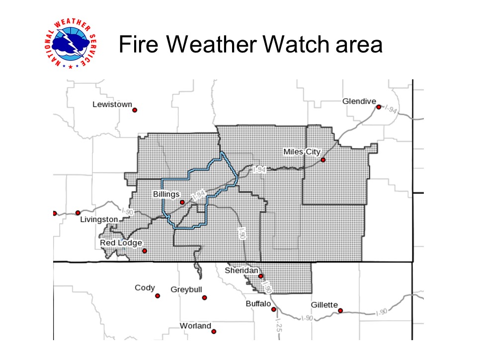
Fire Weather WATCH for Saturday June 19
Related Incident:
Publication Type: Announcement
MTZ125>132-WYZ274-190900-
/O.NEW.KBYZ.FW.A.0004.210619T1800Z-210620T0300Z/
Stillwater County-Beartooth Ranger District Custer National Forest-
Golden Valley County/Musselshell county-Yellowstone County-
Crow Indian Reservation/Bighorn Canyon Rec Area-
Northern Rosebud/Northern Treasure Counties-
Northern Cheyenne Indian Reservation/Ashland Ranger District
Custer Natl Forest-Custer County-Sheridan County-
246 AM MDT Fri Jun 18 2021
...FIRE WEATHER WATCH IN EFFECT FROM SATURDAY AFTERNOON THROUGHSATURDAY EVENING...
The National Weather Service in Billings has issued a Fire Weather
Watch...which is in effect from Saturday afternoon through
Saturday evening.
* IMPACTS: Low humidities, unseasonably warm temperatures, and wind
shift with a cold front may create erratic fire behavior.
* AFFECTED AREA
:In North Central WY Fire Zone...274.
In South Central MT Fire Zones...125...126...127...128...129.
In Southeast MT Fire Zones...130...131...132.
* COUNTIES AFFECTED:
In Central MT...Golden Valley...Musselshell.
In North Central WY...Sheridan.
In South Central MT...Big Horn...Carbon...Park...Stillwater
Sweet Grass...Yellowstone.In Southeast MT...Custer...Powder River...Rosebud...Treasure.
* WIND: Becoming North to Northwest 10 to 20 mph with gusts up to
30 mph.
* HUMIDITY: 15-20 percent.
* TEMPERATURES: In the upper 80s to lower 90s.
PRECAUTIONARY/PREPAREDNESS ACTIONS...
A Fire Weather Watch means that critical fire weather conditions
may occur. Listen for later forecasts and possible Red Flag
Warnings.
&&
Crooked Creek Fire Update June 17 2021 700 pm
Related Incident:
Publication Type: News
CROOKED CREEK FIRE UPDATE
– BLM –
FAA Temporary Flight Restriction over Crooked Creek Fire
Related Incident:
Publication Type: Closures
The Federal Aviation Administration has issued a Temporary Flight Restriction over the area of the Crooked Creek Fire to provide a safe environment so firefighting aircraft may operate in the area.
NOTAM : 1/5085 FDC 1/5085 ZLC MT..AIRSPACE 36NM S OF BILLINGS, MT..TEMPORARY FLIGHT RESTRICTIONS WI AN AREA DEFINED AS 7NM RADIUS OF 451104N1082513W (BIL153038.4) SFC-12500FT. TO PROVIDE A SAFE ENVIRONMENT FOR FIRE FIGHTING ACFT OPS. PURSUANT TO 14 CFR SECTION 91.137(A)(2) TEMPORARY FLIGHT RESTRICTIONS ARE IN EFFECT. USFS TEL 406-896-2900 OR FREQ 118.1250/THE CROOKED CREEK FIRE IS IN CHARGE OF THE OPERATION. SALT LAKE CITY /ZLC/ ARTCC TEL 801-320-2560 IS THE FAA CDN FACILITY. DLY 1400-0300 2106171400-2108170300EST
https://tfr.faa.gov/save_pages/detail_1_5085.html
Stage 1 Fire Restrictions on BLM managed lands in Carbon County
Related Incident:
Publication Type: Announcement
United States Department of the Interior
BUREAU OF LAND MANAGEMENT
Billings Field Office
5001 Southgate Drive
Billings, Montana 59101
http://www.blm.gov/montana-dakotas
Order No. MT-010-21-05
SPECIAL STAGE 1 FIRE RESTRICTIONS
ORDER OF THE BUREAU OF LAND MANAGEMENT
FIELD MANAGER, SETTING FORTH RESTRICTIONS AND CONDITIONS OF USE IN THE
BILLINGS FIELD OFFICE
Campfire: A fire, not within any building, mobile home, or living accommodation mounted on a vehicle, which is used for cooking, branding, personal warmth, lighting, ceremonial, or aesthetic purposes. Campfires are open fires, usually built on the ground, from native fuels or charcoal, including charcoal grills.