
Lookout Towers on the KNP ComplexOctober 8 2021
Related Incident: KNP Complex
Publication Type: News
Lookout Towers on the KNP Complex
The Milk Ranch area burned in the early days of the KNP Complex. As fire activity in that area has substantially cooled, on October 2, crews were able to access it to perform a preliminary assessment of the damage. While the radio repeater equipment was destroyed by the fire, the steel structure and the lookout room appear to be still structurally sound. A more thorough assessment will be completed when conditions in that area have stabilized further.
Buck Rock Fire lookout is being prepped with structure protection wrap around the wooden components in anticipation that the area could see fire. The area where Buck Rock is located has a lot of rocky terrain with sparse fuels, which should be helpful in slowing fire spread into those areas, especially with cooler and wetter weather predicted in the coming days. However, there is a great deal of prep work occurring in that area of Sequoia National Forest right now, as the fire has been very active west of there. Crews are working to hold fire some distance west of Buck Rock (close to the NPS boundary, west of the Generals Highway).
Park Ridge Fire lookout is very close to the northwest edge of the fire. In fact, handlines from the planned, but not yet executed, Park Ridge Prescribed Burn are being used as primary holding features in the fire suppression efforts in that area, right by the lookout. While this does mean that fire is burning very near the lookout, it also means that firefighters are literally on the ground protecting that structure at close range, which has often not been possible for safety reasons elsewhere on this fire.(NPS fire and maintenance staff at Milk Ranch)

KNP Complex North and South Zones Update October 8 2021
Related Incident: KNP Complex
Publication Type: News
KNP Complex North and South Zones Update-October 8, 2021
Acres: 85,952 acres
Containment: 11 %
Start Date: September 10, 2021
Cause: Lightning
Jurisdiction: Sequoia and Kings Canyon National Parks; Sequoia National Forest
Resources: 2,069 personnel including: 40 crews, 133 engines, 36 water tenders, 21 dozers and 14 helicopters
The four individuals struck by a tree on the southern end of the KNP Complex Thursday afternoon, have all been released from the hospital. One is an employee with CALFIRE and three are Corpsmembers with the California Conservation Corps.
North Zone: California Interagency Incident Management Team 2 (CIIMT2) assumed command of the North Zone of the KNP Complex yesterday at 6 pm. The zone will be comprised of the portions of the fire from Eshom Valley on the west side, around the north end of the fire to the Giant Forest on the east side. Team 2 will continue to build on the good work done in the last two weeks by Southwest Incident Management Team 2. Today’s primary focus will be the area where the fire crossed the Generals Highway south of Grant Grove. Last night a tactical firing operation from Park Ridge to Redwood Canyon locked in that portion of the line. Today crews will follow up by patrolling that area and extinguishing hot spots. An indirect line is being constructed around Stony Creek Lodge to the Generals Highway. This line will continue around the lodge and down to Lost Grove. Increased humidity and shading of fuels by clouds will decrease fire behavior and provide more opportunities to build direct line. Firefighters will be scouting the fire and looking for areas where they can build control line directly on the fire’s edge.
South Zone: Southwest Area Incident Management Team 2 remains in command of the South Zone of the KNP Complex. The zone will be comprised of the portions of the fire from Eshom Valley on the west side, around the south end of the fire to the Giant Forest Grove on the east side. Today, firefighters are patrolling the west perimeter and working to extinguish hotspots, preventing further spread. Heavy equipment and crews are implementing structure protection and preparation around Case Mountain Grove, Silver City, and Mineral King. Fire spread to the south of Mineral King Road is being reduced with line construction and hose lays in place.
Weather: A chance of scattered rain across the fire area will increase as we move into the afternoon. Thunderstorms developing in the surrounding area are expected to bring cooler temperatures and gusty winds. Moisture is expected across the fire area with snow in the high elevations.
Safety: Firefighters will continue fire suppression efforts across both the North and South Zones as long as they can do so safely with these changing weather conditions. Firefighter safety is our #1 priority and work objectives may change.
Evacuations: Evacuation ORDERS and WARNINGS are in place. For the most up-to-date information, visit: https://nifc.maps.arcgis.com/apps/webappviewer/index.html?id=4b2ac27b5c8943ed92c0e77aa94daca0. Learn to prepare for an evacuation by visiting https://www.readyforwildfire.org/.
Closures: Sequoia and Kings Canyon National Parks are closed west of the Pacific Crest Trail and south of the ridgeline which lies north of Ionian Basin. In addition, the BLM Case Mountain Extensive Recreation Management Area and major portions of the Sequoia National Forest are also closed. View closures at https://inciweb.nwcg.gov/incident/closures/7838/
Smoke Impacts: A decrease in smoke activity is expected with changes in weather. Current air quality updates can be found at https://www.wildlandfiresmoke.net/outlooks/FresnoCA.
Fire Information:
PUBLIC: (559) 492-9988 (8 a.m. – 8 p.m.); MEDIA: (559) 492-9967
EMAIL: 2021.KNP@firenet.gov
INCIWEB: https://inciweb.nwcg.gov/incident/7838/
FACEBOOK: https://www.facebook.com/sequoiakingsnps/ and https://www.facebook.com/sequoiaNF/
TWITTER: https://twitter.com/SequoiaKingsnps and https://twitter.com/sequoiaforest
INSTAGRAM: https://www.instagram.com/Sequoiakingsnps
YOUTUBE: https://bit.ly/KNPComplexYT
Update on Firefighters Injuries on the KNP Complex Fire
Related Incident: KNP Complex
Publication Type: Announcement
KNP Complex October 7, 2021
Special Announcement
At approximately 3:00 pm this afternoon, the KNP Complex received a radio transmission that a tree had fallen, striking four individuals working on the KNP Complex Fire. The patients were all brought to the nearest helispot and were transported by air to area hospitals. All four individuals are receiving medical care. Thankfully, while the injuries are serious, they are in stable condition, and we are grateful.
Incident on KNP Complex Thursday October 7 2021
Related Incident: KNP Complex
Publication Type: Announcement
We are aware an incident has occurred on the KNP Complex. Agency personnel are responding. We will have additional information available as we are able to confirm it.
KNP ComplexThursday October 7 2021
Related Incident: KNP Complex
Publication Type: Announcement
Announcement:
We are aware an incident has occurred on the KNP Complex. Agency personnel are responding. We will have additional information available as we are able to confirm it.KNP Complex Update October 7 2021
Related Incident: KNP Complex
Publication Type: News
Southwest Area Type 1 Incident Management Team 2
Dave Bales – Incident Commander
Acres: 85,952 acres
Containment: 11 %
Start Date: September 10, 2021
Cause: Lightning
Jurisdiction: Sequoia and Kings Canyon National Parks; Sequoia National Forest
Resources: 1,951 personnel including: 38 crews, 123 engines, 37 water tenders, 21 dozers and 13 helicopters
California Incident Management Team 2, a type one team, has arrived and preparation has begun to separate the KNP Complex into two geographical zones in order to support suppression efforts across the fire area. This team will spend the day gathering information and take control of the KNP Complex North Zone at 6:00 p.m. tonight, Thursday,
October 7, 2021. Southwest Team 2 will remain in command of the KNP Complex South Zone as this transition occurs.
Yesterday: Firefighters continued with tactical firing operations to the north along Old Sawmill Road. On the northern perimeter, the fire crossed a portion of Generals Highway but was caught by crews securing handline around the fires edge. Structure protection continued around Wilsonia, Grant Grove Village and surrounding communities. Crews were able to stop forward progress and place hose lay on the 75-acre spot on the western edge near Advance. An increase in visibility provided opportunities for helicopters to support ground resources with bucket drops for both the 75-acre growth and hotspots located south of Mineral King Road.
Today: Work continues in Eshom Creek with crews connecting the contingency line to Generals Highway along the northwestern corner of the fire. Firefighters are patrolling Old Sawmill Road to ensure the fire stays within the containment line where tactical firing operations are occurring. Structure protection remains in place for Grant Grove Village, Wilsonia, and surrounding communities. Heavy equipment, such as dozers and masticators, are working in coordination with crews to improve contingency lines north of Generals Highway near Park Ridge. Resources are clearing vegetation around Bearskin, Tenmile, Landslide, Grant, and Big Stump sequoia groves to protect areas to the north. For the northeast portion of the fire, dozers are working in the Stony Creek area to clear heavy, dead and down vegetation to provide safe access for crews engaging directly on the fires edge with suppression efforts. Firefighters working on the south end of KNP Complex are improving handline and checking hose lays along the Mineral King Road, east of Oak Grove. Crews are working along the western perimeter near North Fork Drive to locate and cool any hotspots on the 75-acre spot to prevent future growth. Helicopters are available to support firefighters on the ground with bucket drops and reconnaissance flights as visibility allows for the safe operation of flight crews.
Safety: For the safety of the firefighters and public, please observe all closures in place for the Forest Service and National Park. Turn on headlights and slow down when traveling within surrounding communities.
Weather: Light winds, slight decrease in temperature and increase in relative humidities are expected to help moderate fire behavior and slow fire spread. Clouds will move into the area during the afternoon with precipitation possible over the fire late Thursday evening, early Friday morning. Snow is forecasted for the higher elevations as we move into Friday.
Evacuations: Evacuation ORDERS and WARNINGS are in place. For the most up-to-date information, visit: https://nifc.maps.arcgis.com/apps/webappviewer/index.html?id=4b2ac27b5c8943ed92c0e77aa94daca0. Learn to prepare for an evacuation by visiting https://www.readyforwildfire.org/.
Closures: Sequoia and Kings Canyon National Parks are closed west of the Pacific Crest Trail and south of the ridgeline which lies north of Ionian Basin. In addition, the BLM Case Mountain Extensive Recreation Management Area and major portions of the Sequoia National Forest are also closed. View Closures at: https://inciweb.nwcg.gov/incident/closures/7838/
Smoke Impacts: Smoke will remain visible across the fire area as the fire consumes unburned pockets of vegetation. Current air quality updates can be found at https://www.wildlandfiresmoke.net/outlooks/FresnoCA.
Fire Information:
PUBLIC: (559) 492-9988 (8 a.m. – 8 p.m.); MEDIA: (559) 492-9967
EMAIL: 2021.KNP@firenet.gov
INCIWEB: https://inciweb.nwcg.gov/incident/7838/
FACEBOOK:
https://www.facebook.com/sequoiakingsnps/ and https://www.facebook.com/sequoiaNF/
TWITTER:
https://twitter.com/SequoiaKingsnps and https://twitter.com/sequoiaforest
INSTAGRAM:
https://www.instagram.com/Sequoiakingsnps
YOUTUBE:
https://bit.ly/KNPComplexYTKNP Complex Update October 6 2021
Related Incident: KNP Complex
Publication Type: News
Southwest Area Type 1 Incident Management Team 2 Dave Bales– Incident Commander
Acres: 84,166 acres
Containment: 11 %
Start Date: September 10, 2021
Cause: Lightning
Jurisdiction: Sequoia and Kings Canyon National Parks; Sequoia National Forest
Resources: 1,866 personnel including: 38 crews, 111 engines, 34 water tenders, 20 dozers and 13 helicopters
Yesterday, resources successfully conducted tactical firing operations to keep the fire east of Hartland by utilizing natural and constructed holding features along the northwest perimeter. Structure protection continues in Wilsonia, Grant Grove, Quail Flat, and Weston Meadow. Spot fires north of Generals Highway were actively burning through heavy accumulations of fuels on the forest floor. On the north side, bucket drops were used in areas east and north of the Generals Highway. On the southern end, helicopters supported crews as they constructed hose lays on the west side of Mineral King Road.
Today, firefighters continue to construct containment lines along Old Sawmill Road. Hand crews are building direct line from the Park Ridge Lookout (NPS Tower) to the Generals Highway. These efforts are to protect the communities of Wilsonia and Grant Grove. Farther east, firefighters continue to build direct line to contain the fire that has crossed north of Generals Highway near Stoney and Cabin creeks. On the eastern edge of the fire, resources are conducting tactical firing operations east of Morro Rock to protect the Giant Forest Grove. On the southern perimeter, crews are working to prevent the fire from moving toward Oak Grove. Resources on the west flank are working to secure a spot fire overnight. Helicopters and fixed wing aircraft are available to support ground resources across the fire area as smoke lifts and visibility allows.
Firefighters are working hard to contain the KNP Complex Fire. There is a lot of interest in the condition of campgrounds, Sequoia Groves, and historic structures. Current fire conditions are preventing a thorough assessment of the many structures across the fire. In the early days of the fire, two structures in Oriole Lake were damaged or destroyed. Despite clearing of vegetation, water drops and structure wrap, the historic cabin in Redwood Mountain Grove was destroyed by fire on October 4, 2021.
Lighter winds combined with an increase in humidity and a decrease in temperatures should help to slow fire spread. Clouds will begin to move into the area over the next few days.
Please continue to turn on your lights and watch out for fire equipment moving up and down roads. We want to keep both the firefighters and the public safe.
For more detailed information on Evacuation orders and Warnings you can visit: https://nifc.maps.arcgis.com/apps/webappviewer/index.html?id=4b2ac27b5c8943ed92c0e77aa94daca0
Information about how to prepare for evacuations can be found at https://www.readyforwildfire.org/
Sequoia and Kings Canyon National Parks are closed west of the Pacific Crest Trail and south of the ridgeline which lies north of Ionian Basin. In addition, the BLM Case Mountain Extensive Recreation Management Area and major portions of the Sequoia National Forest are also closed. View closures at
Communities surrounding the park and in the nearby region are being affected by smoke and the resulting poor air quality. Track your local air quality at https://www.wildlandfiresmoke.net/outlooks/FresnoCA.
Fire Information:
PUBLIC: (559) 492-9988 (8 a.m. – 8 p.m.); MEDIA: (559) 492-996
EMAIL: 2021.KNP@firenet.gov
INCIWEB: https://inciweb.nwcg.gov/incident/7838/
FACEBOOK:
https://www.facebook.com/sequoiakingsnps/ and https://www.facebook.com/sequoiaNF/
TWITTER:
https://twitter.com/SequoiaKingsnps and https://twitter.com/sequoiaforest
INSTAGRAM:
https://www.instagram.com/Sequoiakingsnps
YOUTUBE:
https://bit.ly/KNPComplexYTNEW Evacuation Order IssuedTulare County Sheriffs Office October 6 2021
Related Incident: KNP Complex
Publication Type: Announcement
UPDATE From Tulare County Sheriff's Office Tulare County Sheriff's Facebook Page Map for Evacuation Orders and Warnings
October 6, 2021
UPDATE: Tulare County Issues New Evacuation Orders for the KNP Complex Fire
VISALIA, CA – Tulare County has issued an Evacuation Order, effective immediately, for all residences on both sides of North Fork Drive from Yacca Creek to Sheep Creek due to the KNP Complex Fire.
There is a road closure at North Fork and Sheep Creek.
An evacuation order means that all residents and visitors should leave now before the fire reaches the community. An evacuation order means an immediate threat to life, safety and property; all residents must evacuate the area.
If you are unable to evacuate and need immediate assistance, please call 911.
The temporary evacuation point, where you may find information, assistance, and shelter options is at the Woodlake Community Center, 145 N. Magnolia. RV/Trailer dry camping is available at the International Agri-Center, 4500 S. Laspina, Gate D, in Tulare. There are water stations and dumping can be scheduled during normal business hours; there is no electricity.
If you are able, please evacuate your domestic animals with you. Tulare County Animal Services is available to assist with evacuating your animals from the fire areas along with housing for both small and large animals. If you are under an evacuation order, please call Shelter Manager Cassandra Heffington at (559) 679-6222.
All other warnings and orders for the KNP Complex fire remain in effect.
Please refer to https://tularecounty.ca.gov/emergencies/ for the KNP Complex Evacuation Area Map. Call 2-1-1 for more information. For more information, visit https://inciweb.nwcg.gov/incident/7838/.
KNP Complex YouTube Channel Videos Link
Related Incident: KNP Complex
Publication Type: Announcement
The KNP Complex now has an incident specific YouTube channel available to view daily updates, weather reports, and community meetings. You can view the channel and subscribe at:

KNP Complex UpdateFacebook Live MeetingOctober 5 2021
Related Incident: KNP Complex
Publication Type: News
Southwest Area Type 1 Incident Management Team 2
Dave Bales – Incident Commander
Acres: 79,382 acres
Containment: 11 %
Start Date: September 10, 2021
Cause: Lightning
Jurisdiction: Sequoia and Kings Canyon National Parks; Sequoia National Forest
Resources: 1,566 personnel including: 27 crews, 90 engines, 35 water tenders, 18 dozers and 13 helicopters
A Virtual Community Meeting will be held at 7:00 pm tonight at https://www.facebook.com/SequoiaKingsNPS/live_videos
Active fire behavior was observed over most of the fire yesterday, making a run as it became established in Redwood Creek on the northern end. Firefighters provided structure protection for Wilsonia, Hartland, Quail Flat, and Grant Grove along the northwest perimeter. The fire crossed Generals Highway near Redwood Mountain Grove and Stoney Creek, causing firefighters to temporarily move to safer locations. On the southern side of the fire, resources worked along the Mineral King Road to contain the spot fires from Sunday night. Firefighters also provided structure protection in Silver City and the Mineral King area. Aircraft were able to support ground resources with bucket drops on Monday once the smoke cleared enough to safely fly.
Today, firefighters will improve control lines along the northwest perimeter to keep the fire east of Hartland and protect Wilsonia, Hartland, Quail Flat, and Grant Grove Village. Resources are working at the Big Whistle area and around park structures to stop the fire from moving any farther north. Along Generals Highway, firefighters are patrolling established firelines near Big Baldy and construct firelines father east by Stoney Creek and Cabin Creek to prevent further spread to the northeast. Resources south of Morro Rock are connecting indirect lines back to established containment lines. On the southern perimeter of the fire, resources are working to contain the fire where it crossed Mineral King Road. Crews are working to keep the fire from progressing south toward Ash Mountain. Structure protection continues for Silver City, the Mineral King area, Three Rivers and Ash Mountain. Aviation assets are available to support firefighting efforts on the ground as visibility improves.
For public and firefighter safety, we ask if you are traveling along road systems near the fire are to please slow down, turn on your lights and watch out fire equipment on the road.
For more detailed information on Evacuation orders and Warnings you can visit: https://nifc.maps.arcgis.com/apps/webappviewer/index.html?id=4b2ac27b5c8943ed92c0e77aa94daca0
A ridge of high pressure finally begins to break down as a low-pressure trough approaches. This will allow a small increase in westerly winds aloft, bringing slightly better smoke mixing in the afternoon. Local winds will remain light, and terrain driven. Humidity levels will rise slowly, which will help to moderate fire behavior.
Information about how to prepare for evacuations can be found at https://www.readyforwildfire.org/
Sequoia and Kings Canyon National Parks are closed west of the Pacific Crest Trail and south of the ridgeline which lies north of Ionian Basin. In addition, the BLM Case Mountain Extensive Recreation Management Area and major portions of the Sequoia National Forest are also closed.
Communities surrounding the park and in the nearby region are being affected by smoke and the resulting poor air quality. Track your local air quality at https://www.wildlandfiresmoke.net/outlooks/FresnoCA.
Fire Information:
PUBLIC: (559) 492-9988 (8 a.m. – 8 p.m.); MEDIA: (559) 492-9967
EMAIL: 2021.KNP@firenet.gov
INCIWEB: https://inciweb.nwcg.gov/incident/7838/
FACEBOOK:
https://www.facebook.com/sequoiakingsnps/ and https://www.facebook.com/sequoiaNF/
TWITTER:
https://twitter.com/SequoiaKingsnps and https://twitter.com/sequoiaforest
INSTAGRAM:
https://www.instagram.com/Sequoiakingsnps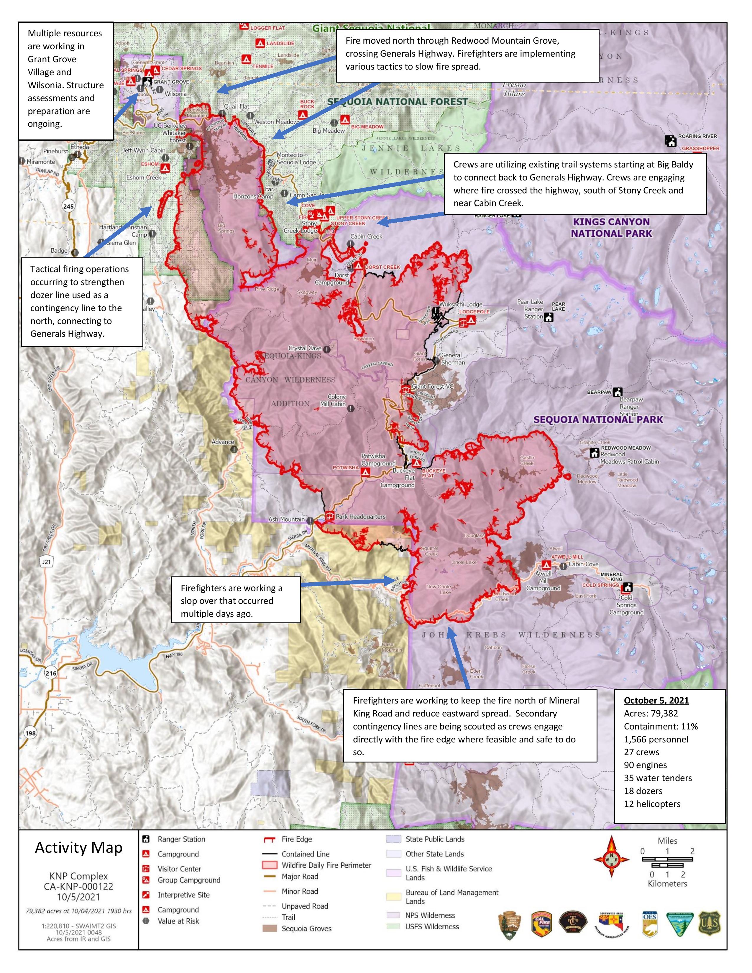