
KNP Complex Update for October 28 2021
Related Incident: KNP Complex
Publication Type: News
October 28, 2021
Acres: 88,307 acres
Containment: 69%
Start Date: September 10, 2021
Cause: Lightning
Jurisdiction: Sequoia and Kings Canyon National Parks; Sequoia National Forest
Resources: 532 personnel including: 8 crews, 13 engines, 5 water tenders, 2 dozers and 6 helicopters
Firefighters on the KNP Complex were able to get back out in areas of the fire perimeter as safety permitted. A fixed-wing aircraft (airplane) surveyed the entire fire area, taking video as well as infrared footage. The flight showed the fire had grown slightly in the northeast area and is moving toward the granite barrier which runs near Kettle Peak, Twin Peaks and Mount Silliman. This granite barrier should halt the fire’s progress and firefighters are monitoring the fire’s activity. The flight also showed fire activity near Atwell Grove. Crews are working to clear mud and debris from Mineral King Road to allow firefighters back into this area as soon as possible. They will then work ensure the fire is not a threat to any Giant Sequoias. Much of the fire has not shown any growth and is staying within established containment lines. Road maintenance crews from Kings Canyon National Park have cleared General’s Highway from the Big Stump area to Ash Mountain. This area is open to administrative staff and emergency traffic only. Road crews will continue working to clear General’s Highway and Mineral King Road toward the Silver City area to allow crews access.
Suppression repair work is continuing in areas where crews have access and can operate safely. While the rain has greatly increased the dead fuel moisture in the 1, 10 and 100-hour fuels, the rain has had very little impact on the 1,000-hour fuels. Dead fuel moisture is the moisture content of dead organic fuels, which is controlled entirely by exposure to environmental conditions. A 1,000-hour fuel is any vegetation or combustible material ranging from 3-6 (or more) inches in diameter. Fire behavior in most areas of the KNP Complex will be minimal, however, there will still be areas of heavy, dead fuels that have been sheltered from precipitation, by leaf canopy or other barriers, or that are burning on the inside. These fuels will continue to give off heat. Smoldering and fire activity is expected to increase as conditions become warmer and drier.
Weather: High pressure will bring further warming and drying through the end of the week with light terrain driven winds. A weak disturbance will move in over northern California this weekend bringing a little cooling and a slight increase in humidity and winds.
Safety: Please be aware of and respect closures and reduce speeds when traveling in and around the fire area.
Evacuations: Visit: https://nifc.maps.arcgis.com/apps/webappviewer/index.html?id=4b2ac27b5c8943ed92c0e77aa94daca0.
Closures: Visit: https://inciweb.nwcg.gov/incident/closures/7838/.
FIRE INFORMATION
PUBLIC INFORMATION AND MEDIA: (925) 588-6773
EMAIL: 2021.KNP@firenet.gov
INCIWEB: https://inciweb.nwcg.gov/incident/7838/
YOUTUBE: https://bit.ly/2021KNPComplex
FACEBOOK: https://www.facebook.com/sequoiakingsnps/ and https://www.facebook.com/sequoiaNF/
TWITTER: https://twitter.com/SequoiaKingsnps and https://twitter.com/sequoiaforest
INSTAGRAM: https://www.instagram.com/Sequoiakingsnps
KNP Complex Update for October 27 2021
Related Incident: KNP Complex
Publication Type: News
October 27, 2021
Acres: 88,307 acres
Containment: 69%
Start Date: September 10, 2021
Cause: Lightning
Jurisdiction: Sequoia and Kings Canyon National Parks; Sequoia National Forest
Resources: 529 personnel including: 8 crews, 15 engines, 4 water tenders, 2 dozers and 6 helicopters
Firefighters are slowly getting back out on the KNP Complex following the inclement weather. Today division Supervisors began to assess each division around the fire’s perimeter to determine whether it was safe enough to redeploy firefighters. Crews were able to access the lower elevations near Ash Mountain to continue suppression repair work. A small mudslide was discovered on Mineral King Road, roughly 1-2 miles from the park’s entrance. Before the containment percentage can be increased, crews need to assess the fire’s edge.
While the rain received on the fire has greatly increased the fuel moisture, the fire is still not “out.” Rain alone is not enough to completely extinguish a wildfire, for the same reason that aerial firefighting, known as “air drops” or “bucket drops” generally cannot stop a wildfire alone. Rain duration is just as important as the amount. An excessive amount of rain, over a short period of time, will run off before the large fuels have had enough time to absorb it. If heavy fuels, such as large logs, cannot absorb enough rain to penetrate the deep layers, it will not eliminate the heat within the fuel. Similarly, if the moisture runs down-hill before the soil can absorb it, any roots or organic material beneath the surface will continue to smolder. This runoff also can result in mudslides and debris flows. Heavy fuels burned by wildfires can smolder for as long as a year or more after the fire has been declared “contained.” Nevertheless, by wetting down the fuels, even slightly, it can slow a fire’s progress very effectively and give firefighters the time they need to contain the fire and mop it up before the next dry spell.
After a fire has stopped advancing, or the fire behavior has decreased, firefighters will patrol the burned areas, known as “the black,” to manually put out embers and locate hot spots among the dirt and ash. This technique, called “cold trailing” involves firefighters working together in a grid pattern, touching the ground, the rocks, and any larger vegetation with their bare hands to search for heat. The firefighters will dig down to locate and extinguish the source of the heat. Crews will cold trail inward from the fire’s edge anywhere from 66 to 100 feet or more, to make sure any smoldering areas will not reignite and threaten the fire containment line. Cold trailing is one of many operations firefighters will conduct during the “mop up” phase of a fire. “Mop up” refers to the method firefighters use for extinguishing or removing burning material near control lines, felling snags, and trenching logs to prevent rolling after an area has burned, to make a fire safe, or to reduce residual smoke.
Weather: High pressure will bring further warming and drying through the end of the week with light terrain driven winds. A weak disturbance will move in over northern California this weekend bringing a little cooling and a slight increase in humidity and winds.
Safety: Please be aware of and respect closures and reduce speeds when traveling in and around the fire area.
Evacuations: Visit: https://nifc.maps.arcgis.com/apps/webappviewer/index.html?id=4b2ac27b5c8943ed92c0e77aa94daca0.
Closures: Visit: https://inciweb.nwcg.gov/incident/closures/7838/.
FIRE INFORMATION
PUBLIC INFORMATION AND MEDIA: (925) 588-6773
EMAIL: 2021.KNP@firenet.gov
INCIWEB: https://inciweb.nwcg.gov/incident/7838/
YOUTUBE: https://bit.ly/2021KNPComplex
FACEBOOK: https://www.facebook.com/sequoiakingsnps/ and https://www.facebook.com/sequoiaNF/
TWITTER: https://twitter.com/SequoiaKingsnps and https://twitter.com/sequoiaforest
INSTAGRAM: https://www.instagram.com/Sequoiakingsnps
KNP Complex Update for October 26 2021
Related Incident: KNP Complex
Publication Type: News
October 26, 2021
Acres: 88,307 acres
Containment: 69%
Start Date: September 10, 2021
Cause: Lightning
Jurisdiction: Sequoia and Kings Canyon National Parks; Sequoia National Forest
Resources: 532 personnel including: 8 crews, 14 engines, 4 water tenders, 2 dozers and 7 helicopters
Rain is the big news on the KNP Complex. Incident Meteorologists said between 2-3 inches of rain fell on all parts of the fire. Some areas at higher elevations saw slightly more rain than others. About 3 inches of snow fell on the satellite camp at Hume Lake. Firefighters sheltered in place throughout the day Monday and incident supervisors will go into the field today to assess the conditions. When safety permits, the crews will reengage the fire.
When weather or fire conditions become too dangerous for crews to engage in active firefighting, they do not remain idle. Engine crews, water tender drivers and heavy equipment operators will use this time to go over their rigs. They will check for any potential mechanical problems, inventory and inspect all their equipment, and perform routine maintenance to ensure they are ready to go as soon as they are able. Hand crews will inspect and maintain their tools and falling modules will perform inspection and maintenance on their chainsaws. One important task firefighters will perform during “downtime” is to review the Medical Incident Report (MIR) and discuss how they will respond in the event of a medical emergency. These reviews can be as simple as practicing how to gather information to use in the MIR or discussing possible scenarios and how to get medical attention to the patient. In some instances, firefighters will involve the incident’s medical staff in these trainings to better familiarize themselves with what resources are available.
The medical emergency protocols, which would evolve into the MIR, were developed following the Dutch Creek incident in 2008. During that incident, 18-year-old Andrew “Andy” Palmer died from injuries sustained when he was struck by a falling tree. As time progressed, these same protocols were revised into the MIR, also referred to as the “8-lines.” The MIR is a written set of guidelines used by firefighters to communicate critical information, such as the nature and severity of the injury, the patient’s location, and how the patient will be taken from the accident site to a medical facility. Reviewing the MIR can save valuable time during any emergency.
Weather: Cool, moist, and breezy conditions will move into the area Tuesday. A warming and drying trend will occur through the week with light terrain-driven winds. A weak disturbance is expected to move over the northern California coast this weekend bringing cooler temperatures and a slight increase in winds.
Safety: Please be aware of and respect closures and reduce speeds when traveling in and around the fire area.
Evacuations: Visit: https://nifc.maps.arcgis.com/apps/webappviewer/index.html?id=4b2ac27b5c8943ed92c0e77aa94daca0.
Closures: Visit: https://inciweb.nwcg.gov/incident/closures/7838/.
FIRE INFORMATION
PUBLIC INFORMATION AND MEDIA: (925) 588-6773
EMAIL: 2021.KNP@firenet.gov
INCIWEB: https://inciweb.nwcg.gov/incident/7838/
YOUTUBE: https://bit.ly/2021KNPComplex
FACEBOOK: https://www.facebook.com/sequoiakingsnps/ and https://www.facebook.com/sequoiaNF/
TWITTER: https://twitter.com/SequoiaKingsnps and https://twitter.com/sequoiaforest
INSTAGRAM: https://www.instagram.com/Sequoiakingsnps
KNP Complex Update for October 25 2021
Related Incident: KNP Complex
Publication Type: News
October 25, 2021
Acres: 88,307 acres
Containment: 63%
Start Date: September 10, 2021
Cause: Lightning
Jurisdiction: Sequoia and Kings Canyon National Parks; Sequoia National Forest
Resources: 527 personnel including: 7 crews, 15 engines, 4 water tenders, 2 dozers and 7 helicopters
Containment on the KNP Complex has increased to 63 percent. Firefighters are monitoring the weather and will be adjusting their operations as safety permits. If necessary, crews will shelter in place and re-engage as soon as the weather allows. Firefighters will soon be transitioning to suppression repair work in areas of the fire that are uncontained but have shown no movement and no heat signatures. The firefighters have been utilizing Minimal Impact Suppression Tactics to help assist with restoring the burn area.
Minimal Impact Suppression Techniques or Minimal Impact Suppression Tactics (MIST) refers to a method of firefighting designed to minimize the effects of fire suppression activities on the land, wildlife, watersheds, and facilities. MIST has established several guidelines utilized protect these resources while accounting for firefighter safety. Some of these methods include allowing fires to burn to natural barriers; using the minimum depth and width of fire containment lines to check the fire’s spread while disturbing the ground as little as possible; using equipment such as excavators and rubber-tired tractors instead of dozers; cutting shrubs or small trees only when necessary; cutting trees or snags only when they threaten containment lines or the safety of personnel and avoiding dropping retardant or other suppressants within 300 feet of surface water when possible, to name a few.
When doing suppression repair work, fire crews will scatter any small trees or large brush cut during containment line construction to give a more natural appearance. Woodchippers can be used to reduce vegetation and spread organic material to conceal bare soil areas. Soil and decomposing plant material (duff), which was dug out to stop the fire spread should be spread back where it was removed. Waterbars can be constructed on slopes greater than six percent to intercept water flowing down-hill and divert it to areas with more vegetation and more soil stability. Crews also work to remove all signs of human activity, such as flagging, trash, and equipment.
Weather: A Flash Flood Watch is in effect until 11 pm today, due to the potential for flash flooding and debris flows. Moderate to heavy rain is expected to bring with 2-3 inches over central California, and as much as 5 inches possible in higher elevations.
Safety: Please be aware of and respect closures and reduce speeds when traveling in and around the fire area.
Evacuations: Visit: https://nifc.maps.arcgis.com/apps/webappviewer/index.html?id=4b2ac27b5c8943ed92c0e77aa94daca0.
Closures: Visit: https://inciweb.nwcg.gov/incident/closures/7838/.
FIRE INFORMATION
PUBLIC INFORMATION AND MEDIA: (925) 588-6773
EMAIL: 2021.KNP@firenet.gov
INCIWEB: https://inciweb.nwcg.gov/incident/7838/
YOUTUBE: https://bit.ly/2021KNPComplex
FACEBOOK: https://www.facebook.com/sequoiakingsnps/ and https://www.facebook.com/sequoiaNF/
TWITTER: https://twitter.com/SequoiaKingsnps and https://twitter.com/sequoiaforest
INSTAGRAM: https://www.instagram.com/Sequoiakingsnps
KNP Complex Update for October 24 2021
Related Incident: KNP Complex
Publication Type: News
KNP Complex Update
October 24, 2021
Start Date: September 10, 2021 Cause: Lightning
Jurisdiction: Sequoia and Kings Canyon National Parks; Sequoia National Forest
Resources: 587 personnel including: 11 crews, 15 engines, 4 water tenders, 2 dozers and 7 helicopters
Changing weather is already making its presence known on the KNP Complex, and the fire showed no growth along the existing perimeter. Fog and cloud cover grounded aircraft, due to limited visibility, but helped to moderate fire behavior. Crews working near Atwell Grove, along Mineral Kings Road, were pulled away from their work assignments due to slick road conditions and drivers using excessive speed. Motorists are asked to please be mindful of fire personnel and fire apparatus working along roads.
Since the fire started Sept. 10, firefighters have constructed 47.25 miles of direct dozer line and 7.99 miles of direct hand line; 31.67 miles of indirect dozer line and 16.59 miles of indirect hand line. At its peak, there were 2,118 people working on the fire. Of the 88,307 acres burned, 78,168 belong to the National Park Service; 7,086 belong to the National Forest Service; 1,162 belong to the Bureau of Land Management; and 1,862 belong to private or other entities. There has been a total of five Incident Management Teams in charge of managing the fires.
An Incident Management Team (IMT) is dispatched to manage the operational, logistical, informational, planning, fiscal, community, political, and safety issues associated with complex incidents. IMTs include people from federal, state, local, tribal, and territorial entities. National "Type 1" IMTs are available for assignment to manage large-scale, complex incidents anywhere in the United States. These incidents usually involve large wildfires; however, Type 1 Teams can be assigned to any complex all-risk situation which could include hurricanes, floods, and other disasters. National “Type 2” IMTs can be assigned to major fires, VIP visits, lengthy search and rescues, law enforcement incidents, multi-day special events. There are 14 Type 1 and 23 Type 2 IMTs across the country. Each team is deployed to an incident for 14-21 days before another IMT is brought in to relieve them. The teams are required to take three days off before being placed available for another assignment.
Weather: A Flash Flood Watch is in effect from 11 pm Sunday through 11 pm Monday due to the potential for flash flooding and debris flows. A strong storm system will drive narrow a corridor of concentrated moisture, known as an “atmospheric river” inland over northern California on Sunday. Rain will become moderate to heavy at times overnight through Monday.
Safety: Please be aware of and respect closures and reduce speeds when traveling in and around the fire area.
Evacuations: Visit: https://nifc.maps.arcgis.com/apps/webappviewer/index.html?id=4b2ac27b5c8943ed92c0e77aa94daca0.
Closures: Visit: https://inciweb.nwcg.gov/incident/closures/7838/.
FIRE INFORMATION
PUBLIC INFORMATION AND MEDIA: (925) 588-6773
EMAIL: 2021.KNP@firenet.gov
INCIWEB: https://inciweb.nwcg.gov/incident/7838/
YOUTUBE: https://bit.ly/2021KNPComplex
FACEBOOK: https://www.facebook.com/sequoiakingsnps/ and https://www.facebook.com/sequoiaNF/
TWITTER: https://twitter.com/SequoiaKingsnps and https://twitter.com/sequoiaforest
INSTAGRAM: https://www.instagram.com/Sequoiakingsnps
Actualizacin sobre el complejo KNP 23 de octubre de 2021
Related Incident: KNP Complex
Publication Type: News
Actualización sobre el complejo KNP
23 de octubre de 2021
Acres: 88,307 acres Contención: 60 %
Fecha de inicio: 10 de septiembre de 2021 Causa: Rayos
Jurisdicción: Parques Nacionales Sequoia y Kings Canyon; Parque Nacional Sequoia
Recursos: 587 miembros del personal, 11 cuadrillas manuales, 13 vehículos de bomberos, 16 camiones cisterna, 6 buldóceres y 7 helicópteros
La contención se mantiene en un 60 % en el Complejo KNP. Sin embargo, las cuadrillas continúan reforzando las áreas del incendio que no han sido declaradas contenidas. Muchas de estas áreas se encuentran en terrenos empinados de difícil acceso y contienen numerosos árboles peligrosos. Los troncos y ramas en llamas podrían rodar y traspasar las líneas de contención, las brasas podrían ser arrastradas por el viento y las zonas de calor residual avivadas por el viento podrían volver a encenderse. Los bomberos deben patrullar para localizar estos peligros y mitigarlos. El Equipo de manejo de incidentes aumentará gradualmente el porcentaje de contención cuando considere que es poco probable que el incendio se desplace más allá de estas líneas de control.
Los bomberos continúan trabajando en la reparación de la supresión en las zonas en las que se ha declarado que el incendio está contenido. Las cuadrillas manuales y la maquinaria están trabajando para reparar las líneas construídas con excavadoras y colocando matorrales para que actúen como barreras naturales para evitar la erosión y frenar el exceso de escorrentía de las aguas pluviales. Otras labores de reparación de la supresión implican el uso de camiones cisterna y máquinas niveladoras para reparar cualquier daño en los caminos de tierra.
Un equipo de respuesta de emergencia para área quemada (Burned Area Emergency Response Team, BAER) ha llegado y pasará las próximas dos semanas evaluando y recopilando información en todo el perímetro del incendio. El equipo recopilará datos para minimizar las amenazas a la vida humana y a la propiedad, así como formas de estabilizar y reducir la degradación inaceptable de los recursos naturales críticos. Los especialistas del equipo BAER evaluarán los efectos del incendio en las infraestructuras, los suelos, las cuencas, los peces, la fauna silvestre y la vegetación. El equipo analizará esta información y elaborará un informe final con propuestas sobre cómo mitigar los daños. Este informe se entregará a la dirección de Parques y Bosques, que se encargará de aplicar las propuestas.
Condiciones meteorológicas: Un estrecho corredor de humedad concentrada, conocido como "río atmosférico", se desplazará hacia la zona provocando entre 2 y 3 pulgadas de lluvia desde la noche del domingo hasta la tarde del lunes. Algunas áreas pueden llegar a tener hasta 5 pulgadas de lluvia. Se ha emitido una alerta de inundación repentina para el domingo y lunes, debido a la posibilidad de inundaciones repentinas y flujo de escombros.
Seguridad: Preste atención y respete los cierres, y reduzca la velocidad al viajar en o cerca del área del incendio.
Evacuaciones: Visite: https://nifc.maps.arcgis.com/apps/webappviewer/index.html?id=4b2ac27b5c8943ed92c0e77aa94daca0.
Cierres: Visite: https://inciweb.nwcg.gov/incident/closures/7838/.
INFORMACIÓN SOBRE INCENDIOS
PÚBLICO: (559) 494-4881 (8:00 a. m. – 8:00 p. m.)
MEDIOS: (925) 588-6773
CORREO ELECTRÓNICO: 2021.KNP@firenet.gov
INCIWEB: https://inciweb.nwcg.gov/incident/7838/
FACEBOOK: https://www.facebook.com/sequoiakingsnps/ y https://www.facebook.com/sequoiaNF/
TWITTER: https://twitter.com/SequoiaKingsnps y https://twitter.com/sequoiaforest
INSTAGRAM: https://www.instagram.com/Sequoiakingsnps
YOUTUBE: https://bit.ly/2021KNPComplex
KNP Complex Update for October 23 2021
Related Incident: KNP Complex
Publication Type: News
October 23, 2021
Acres: 88,307 acres
Containment: 60%
Start Date: September 10, 2021
Cause: Lightning
Jurisdiction: Sequoia and Kings Canyon National Parks; Sequoia National Forest
Resources: 587 personnel including: 11 crews, 13 engines, 16 water tenders, 6 dozers and 7 helicopters
Containment remains at 60 percent on the KNP Complex. The fire has not gained any acreage; however, crews are continuing to strengthen areas of the fire which have not been declared contained. Many of these areas are in steep terrain that is difficult to access and contain numerous hazard trees. Burning logs and branches could potentially roll beyond the containment lines, embers may be carried on the wind, and areas of residual heat fanned by the wind could reignite. Firefighters must patrol to locate these dangers and mitigate them. The Incident Management Team will gradually increase the containment percentage when they feel the fire is unlikely to move beyond these control lines.
Firefighters are continuing to work on suppression repair in areas where the fire has been declared contained. Hand crews and machinery are working to repair dozer line and placing brush to act as natural barriers to prevent erosion and to slow excess stormwater runoff. Other suppression repair efforts involve using water tenders and graders to repair any damage to dirt roadways.
A Burned Area Emergency Response Team (BAER) has arrived and will spend the next two weeks assessing and gathering information throughout the burn perimeter. The team will be gathering data to minimize threats to human life and property, as well as ways to stabilize and reduce unacceptable degradation of critical natural resources. The BAER team’s specialists will assess the effects of the fire on infrastructure, soils, the watershed, fish and wildlife, and vegetation. The team will then analyze this information and put together a final report with proposals about how to mitigate the damage. This report will be turned over to the Parks and Forest leadership, who will then work to implement the proposals.
Weather: A narrow corridor of concentrated moisture, known as an “atmospheric river” will move into the area bringing between 2-3 inches of rain late Sunday night through Monday afternoon. Some areas may see as much as 5 inches of rainfall. A Flash Flood Watch has been issued Sunday and Monday, due to the potential for flash flooding and debris flows.
Safety: Please be aware of and respect closures and reduce speeds when traveling in and around the fire area.
Evacuations: Visit: https://nifc.maps.arcgis.com/apps/webappviewer/index.html?id=4b2ac27b5c8943ed92c0e77aa94daca0.
Closures: Visit: https://inciweb.nwcg.gov/incident/closures/7838/.
FIRE INFORMATION
PUBLIC INFORMATION AND MEDIA: (925) 588-6773
EMAIL: 2021.KNP@firenet.gov
INCIWEB: https://inciweb.nwcg.gov/incident/7838/
YOUTUBE: https://bit.ly/2021KNPComplex
FACEBOOK: https://www.facebook.com/sequoiakingsnps/ and https://www.facebook.com/sequoiaNF/
TWITTER: https://twitter.com/SequoiaKingsnps and https://twitter.com/sequoiaforest
INSTAGRAM: https://www.instagram.com/Sequoiakingsnps
Actualizacin sobre el complejo KNP 22 de octubre de 2021
Related Incident: KNP Complex
Publication Type: News
Actualización sobre el complejo KNP
22 de octubre de 2021
Fecha de inicio: 10 de septiembre de 2021 Causa: Rayos
Jurisdicción: Parques Nacionales Sequoia y Kings Canyon; Parque Nacional Sequoia
Recursos: 622 miembros del personal, 8 cuadrillas, 15 camiones de bomberos, 16 camiones cisterna, 6 excavadoras y 20 helicópteros
Ayer, la actividad del incendio fue mínima y las cuadrillas lograron ganar terreno valioso en sus tareas de finalización de las líneas de contención y en las actividades de reparación de la extinción.
incidentes determinan qué valores críticos existen en un área de incendios al considerar los objetivos durante la respuesta inicial al incendio, así como los recursos que podrían verse amenazados por un potencial crecimiento del incendio en el futuro. En el complejo KNP, se determinó que algunos de estos valores críticos eran las arboledas de secuoyas, las cuales son reconocidas internacionalmente como tesoros e hitos históricos por ser exclusivas de esta área. Tomar decisiones informadas en cuanto los riesgos para minimizar los impactos del incendio en las arboledas de secuoyas ha sido una prioridad para cada equipo asignado a este complejo desde el día de su descubrimiento. Tomar decisiones en función de los riesgos requiere evaluar y ponderar las consideraciones de seguridad respecto de los resultados deseados. Considerar estas inquietudes respecto de la seguridad y planificar las tareas diarias es un esfuerzo coordinado. Los árboles peligrosos y la mitigación requerida para garantizar el bienestar de la vida y las estructuras es una de las principales consideraciones de seguridad que deben considerar los administradores del complejo KNP.
Los árboles peligrosos (debilitados por la sequía, enfermedades, antigüedad o los incendios) tienen altas probabilidades de caerse, ya sea parcial o totalmente, y golpear a personas, automóviles, otras estructuras, o bien crear obstáculos para los servicios de respuesta ante emergencias. Los informes indican que hay más de diez mil árboles potencialmente peligrosos a lo largo de Generals Highway. Esta cifra no incluye los árboles peligrosos en las áreas rurales. Los guardaparques y los administradores de incendios y restauración han estado trabajando en colaboración
Los administradores depara desarrollar medidas de mitigación para los árboles peligrosos. Actualmente, complejo KNP tiene varias cuadrillas con sierras ubicadas de forma estratégica a lo largo de Generals Highway, a fin de crear zonas de tránsito seguro para los bomberos, residentes y futuros visitantes. Hasta que no se logre un progreso mayor en las carreteras principales dentro del área del incendio, esos caminos permanecerán cerrados. Las cuadrillas con sierras y las taladoras apiladoras están trabajando constantemente en el complejo KNP y su alrededor, y en las próximas actualizaciones se incluirá un detalle más específico del trabajo que realizan estas cuadrillas.
Condiciones meteorológicas: Una perturbación débil traerá una leve probabilidad de lluvias ligeras hoy y mañana, con condiciones más frescas y con brisa. Se esperan potenciales lluvias de final de temporada desde fines de la semana hasta principios de la semana próxima, con mayores precipitaciones durante el lunes.
Seguridad: Preste atención y respete los cierres, y reduzca la velocidad al viajar en o cerca del área del incendio.
Evacuaciones: Visite: https://nifc.maps.arcgis.com/apps/webappviewer/index.html?id=4b2ac27b5c8943ed92c0e77aa94daca0.
Cierres: Visite: https://inciweb.nwcg.gov/incident/closures/7838/.
INFORMACIÓN SOBRE INCENDIOS
PÚBLICO: (559) 494-4881 (8:00 a. m. – 8:00 p. m.)
MEDIOS: (925) 588-6773
CORREO ELECTRÓNICO: 2021.KNP@firenet.gov
INCIWEB: https://inciweb.nwcg.gov/incident/7838/
FACEBOOK: https://www.facebook.com/sequoiakingsnps/ y https://www.facebook.com/sequoiaNF/
TWITTER: https://twitter.com/SequoiaKingsnps y https://twitter.com/sequoiaforest
INSTAGRAM: https://www.instagram.com/Sequoiakingsnps
YOUTUBE: https://bit.ly/2021KNPComplex
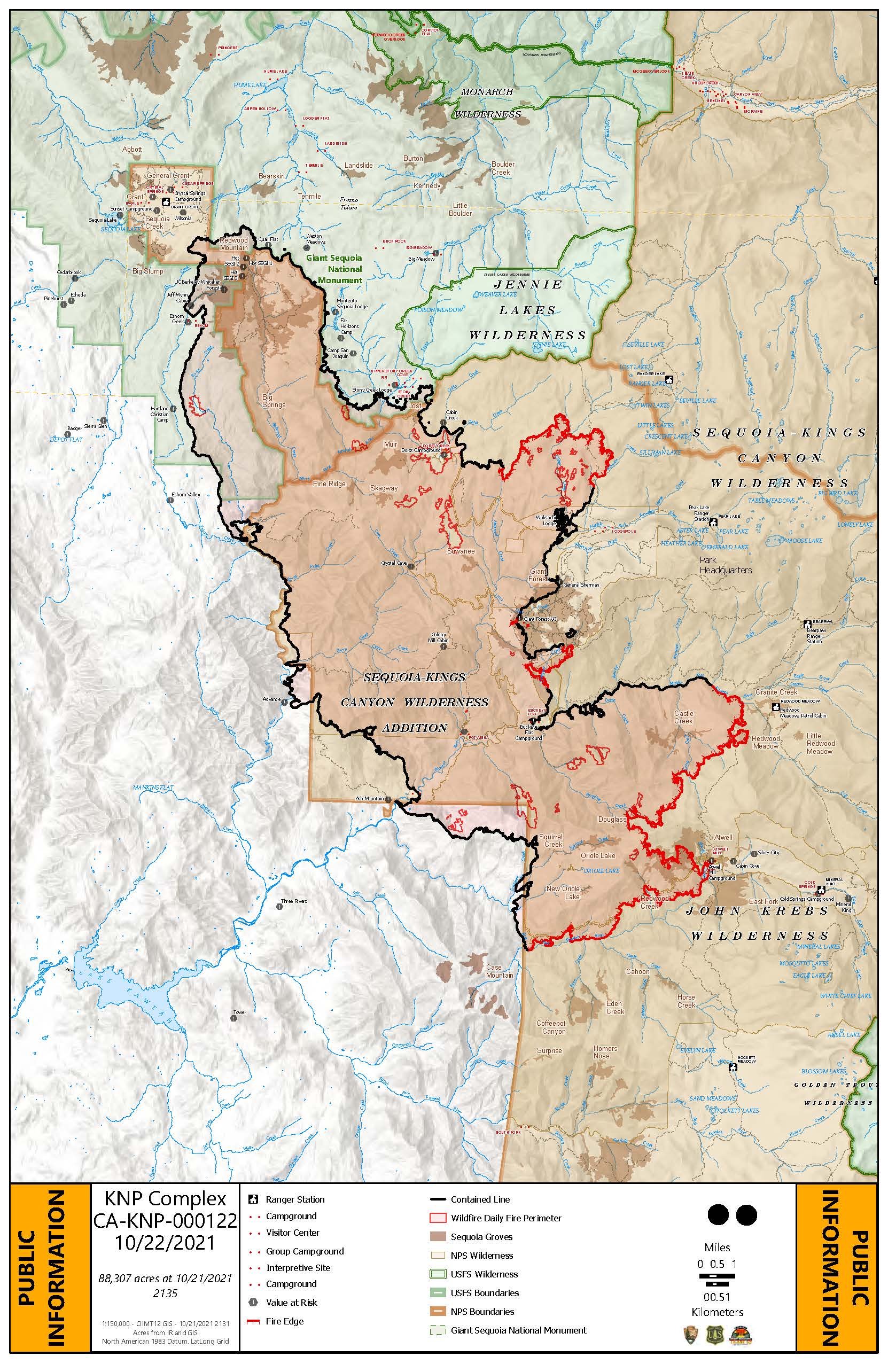
KNP Complex Update for October 22 2021
Related Incident: KNP Complex
Publication Type: News
Acres: 88,307 acres Containment: 60%
Start Date: September 10, 2021 Cause: Lightning
Jurisdiction: Sequoia and Kings Canyon National Parks; Sequoia National Forest
Resources: 622 personnel including: 8 crews, 15 engines, 16 water tenders, 6 dozers and 20 helicopters
Yesterday, fire activity was minimal and crews were able to gain valuable ground working toward the completion of containment lines and suppression repair activities.
Incident managers determine which critical values exist in a fire area when considering objectives during initial fire response, along with assets that could be threatened by potential future fire growth. In the KNP Complex, some of these critical values were determined to be the sequoia groves that are internationally recognized treasures and historic landmarks which are unique to this area. Making risk-informed decisions to minimize fire impacts to the sequoia groves has been a priority for every team assigned to this complex since its date of discovery. Risk-informed decision making requires evaluating and weighing safety considerations against desired outcomes. Considering those safety concerns and planning daily tasks is a coordinated effort. Hazard trees and the mitigation required to ensure life and structure welfare is one of the major safety considerations KNP Complex managers must consider.
Hazard trees—weakened by drought, disease, age, and/or fire—have a high probability to fail in part or whole and have the potential to strike people, cars, other structures, or create barriers to emergency response services. Reports indicate that there are upwards of ten thousand potential hazard trees along the Generals Highway. This count does not include hazard trees in the backcountry. Park foresters, fire and restoration managers have been working cooperatively to develop hazard tree mitigation actions. The KNP Complex currently has several saw crews strategically placed working along the Generals Highway to create safe travel zones for firefighters, residents, and future visitors. Until more progress has been made along major routes within the fire area, those roads will not open. Saw crews and feller bunchers are steadily working in and around the KNP Complex, and future updates will document more specific work being done by these crews.
Weather: A weak disturbance will bring a slight chance of light showers today and tomorrow, with cooler and breezy conditions. A potential season-ending rain event is expected by late this weekend into early next week, with most of the precipitation arriving Monday.
Safety: Please be aware of and respect closures and reduce speeds when traveling in and around the fire area.
Evacuations: Visit: https://nifc.maps.arcgis.com/apps/webappviewer/index.html?id=4b2ac27b5c8943ed92c0e77aa94daca0.
Closures: Visit: https://inciweb.nwcg.gov/incident/closures/7838/.
FIRE INFORMATION
PUBLIC INFORMATION AND MEDIA: (925) 588-6773
EMAIL: 2021.KNP@firenet.gov
INCIWEB: https://inciweb.nwcg.gov/incident/7838/
YOUTUBE: https://bit.ly/2021KNPComplex
FACEBOOK: https://www.facebook.com/sequoiakingsnps/ and https://www.facebook.com/sequoiaNF/
TWITTER: https://twitter.com/SequoiaKingsnps and https://twitter.com/sequoiaforest
INSTAGRAM: https://www.instagram.com/Sequoiakingsnps
KNP Complex Update October 21 2021
Related Incident: KNP Complex
Publication Type: News
October 21, 2021
Acres: 88,307 acres
Containment: 60%
Start Date: September 10, 2021
Cause: Lightning
Jurisdiction: Sequoia and Kings Canyon National Parks; Sequoia National Forest
Resources: 567 personnel including: 8 crews, 15 engines, 16 water tenders, 6 dozers and 11 helicopters
California Incident Management Team 12 assumed command of the KNP Complex yesterday at 1800 under the direction of Incident Commander Mike Nobles.
There is still a fair amount of snow over a large portion of the fire area, so no forward fire progression was made yesterday and none is expected today. Creeping, backing and smoldering activity will be prevalent where fuels are deep, dense and dry and only minimally impacted by snow cover. Fire weakened trees will continue to fall, which is a consideration when planning crew placement and suppression activities each day.
Today’s activities will remain mop up and patrol operations on all current control lines, in addition to direct line construction on the eastern and southern edges to tie together existing contingency lines. Daily coordination is taking place among land agencies, incident management teams, and local resource advisors to prioritize the giant sequoia groves and actions that will support limiting mortality in the groves. Intense suppression repair activities have been a priority all week in areas fully contained and controlled. Most of the suppression repair activities have been around the Hume Lake area, and on the western edge of the fire.
Weather: Slight warming today is expected. Winds will remain light and terrain-driven with a continued west-southwest flow at the ridgetops. A weak disturbance will bring a slight chance of light showers Friday and Saturday with cooler and breezy conditions. Forecast models continue to show the potential for an atmospheric river to impact the fire area by late this weekend into early next week, with the majority of precipitation arriving Monday.
Safety: Please be aware of and respect closures and reduce speeds when traveling in and around the fire area.
Evacuations: Visit: https://nifc.maps.arcgis.com/apps/webappviewer/index.html?id=4b2ac27b5c8943ed92c0e77aa94daca0.
Closures: Visit: https://inciweb.nwcg.gov/incident/closures/7838/.
FIRE INFORMATION
PUBLIC: (559) 494-4881 (8 a.m. – 8 p.m.)
MEDIA: (925) 588-6773
EMAIL: 2021.KNP@firenet.gov
INCIWEB: https://inciweb.nwcg.gov/incident/7838/
FACEBOOK:
https://www.facebook.com/sequoiakingsnps/ and https://www.facebook.com/sequoiaNF/
TWITTER:
https://twitter.com/SequoiaKingsnps and https://twitter.com/sequoiaforest
INSTAGRAM:
https://www.instagram.com/Sequoiakingsnps
YOUTUBE: