
Actualizacin del complejo KNP 15 de octubre de 2021
Related Incident: KNP Complex
Publication Type: News
Acres: 87,786 acres
Contención: 45 %
Fecha de inicio: 10 de septiembre de 2021
Causa: Rayos
Jurisdicción: Parques Nacionales Sequoia y Kings Canyon; Parque Nacional Sequoia
Recursos: 1,460 miembros del personal, 22 cuadrillas manuales, 82 vehículos de bomberos, 31 camiones cisterna, 7 buldóceres y 14 helicópteros
Hoy, a lo largo de los bordes oeste y norte del complejo KNP, las cuadrillas realizarán actividades de patrullaje y neutralización, además de iniciar la reparación de la extinción mediante la colocación estratégica de equipo, como buldóceres y astilladoras, en las áreas que requieren trabajo adicional. Los bomberos laboran en el área entre Montecito Lodge y Stony Creek para asegurar la contención y aislar los puntos calientes, a fin de evitar una propagación adicional. En el flanco sudeste, el fuego retrocederá lentamente hacia Cliff Creek. Hay una zona quemada en años anteriores, entre el incendio y el arroyo; por lo tanto, si el incendio llega a la zona quemada, las aeronaves serán muy eficaces para responder con tácticas de extinción. Los árboles muertos y el terreno escarpado e inaccesible representan una amenaza para la seguridad de los bomberos, por lo cual se emplearán sistemas de aeronaves no tripuladas (drones) para asistir en esas áreas. La reparación de la extinción en las líneas de contingencia comenzará cuando sea apropiado y seguro hacerlo. Los grupos de protección de estructuras patrullarán y monitorearán todo el perímetro del incendio.
Conforme las temperaturas de esta semana calienten más materiales combustibles susceptibles, el comportamiento activo del fuego en dirección al interior producirá más humo que se asentará en los valles y los cañones. No se espera un avance más allá de la huella actual del incendio.
Condiciones meteorológicas: Las condiciones meteorológicas permanecerán cálidas y secas hasta el fin de semana. No se anticipan cambios considerables más que algunas nubes hasta el final de la semana.
Seguridad: Preste atención y respete los cierres, y reduzca la velocidad al viajar en o cerca del área del incendio.
Evacuaciones: Hay ÓRDENES y ADVERTENCIAS de evacuación vigentes. Para obtener la información más reciente, visite: https://nifc.maps.arcgis.com/apps/webappviewer/index.html?id=4b2ac27b5c8943ed92c0e77aa94daca0. Aprenda a prepararse para una evacuación al visitar https://www.readyforwildfire.org/.
Cierres: Los Parques Nacionales Sequoia y Kings Canyon están cerrados al oeste de Pacific Crest Trail y al sur de la cordillera situada al norte de la cuenca Ionian. Además, el Área de Gestión Recreativa Extendida de la Oficina de Administración de Tierras en Case Mountain y grandes secciones del Bosque Nacional Sequoia también están cerradas. Consulte sobre los cierres en https://inciweb.nwcg.gov/incident/closures/7838/.
Impactos de humo: Puede encontrar las actualizaciones sobre la calidad actual del aire en https://www.wildlandfiresmoke.net/outlooks/FresnoCA.
INFORMACIÓN SOBRE INCENDIOS
PÚBLICO: (559) 494-4881 (8:00 a. m. – 8:00 p. m.)
MEDIOS: (925) 588-6773
CORREO ELECTRÓNICO: 2021.KNP@firenet.gov
INCIWEB: https://inciweb.nwcg.gov/incident/7838/
FACEBOOK:
https://www.facebook.com/sequoiakingsnps/ y https://www.facebook.com/sequoiaNF/
TWITTER:
https://twitter.com/SequoiaKingsnps y https://twitter.com/sequoiaforest
INSTAGRAM:
https://www.instagram.com/Sequoiakingsnps
YOUTUBE:
https://bit.ly/2021KNPComplex
KNP Complex North and South Zones Update October 15 2021
Related Incident: KNP Complex
Publication Type: News
KNP Complex North and South Zones Update
October 15, 2021
Acres: 87,786 acres
Containment: 45%
Start Date: September 10, 2021
Cause: Lightning
Jurisdiction: Sequoia and Kings Canyon National Parks; Sequoia National Forest
Resources: 1,460 personnel including: 22 crews, 82 engines, 31 water tenders, 7 dozers and 14 helicopters
Along the western and northern boundaries of the KNP Complex today, crews will perform patrol and mop-up activities, as well as initiating suppression repair by strategically placing equipment such as dozers and chippers along areas needing additional work. Firefighters are working in the area between Montecito Lodge and Stony Creek to secure containment and to isolate hot spots to prevent further spread. On the southeast flank, the fire will slowly back toward Cliff Creek. There is a prior-year burn scar between the fire and the creek, so if the fire reaches the burn scar, aircraft will be very effective in responding with suppression tactics. Snags and steep, inaccessible terrain remain a threat to the safety of firefighters, so unmanned aircraft systems (drones) will assist in those areas. Suppression repair on contingency lines will commence where it is appropriate and safe to do so. Structure protection groups will be patrolling and monitoring the full perimeter of the fire.
As the warmer temperatures this week dry more receptive fuels, active fire behavior moving toward the interior will produce more smoke which will settle in the valleys and canyons. No forward progression is expected beyond the current fire footprint.
Weather: Weather conditions will remain warm and dry through the end of the week. No appreciable changes other than a few clouds are anticipated through the end of the week.
Safety: Please be aware of and respect closures and reduce speeds when traveling in and around the fire area.
Evacuations: Evacuation ORDERS and WARNINGS are in place. For the most up-to-date information, visit: https://nifc.maps.arcgis.com/apps/webappviewer/index.html?id=4b2ac27b5c8943ed92c0e77aa94daca0. Learn to prepare for an evacuation by visiting https://www.readyforwildfire.org/.
Closures: Sequoia and Kings Canyon National Parks are closed west of the Pacific Crest Trail and south of the ridgeline which lies north of Ionian Basin. In addition, the BLM Case Mountain Extensive Recreation Management Area and major portions of the Sequoia National Forest are also closed. View closures at https://inciweb.nwcg.gov/incident/closures/7838/.
Smoke Impacts: Current air quality updates can be found at https://www.wildlandfiresmoke.net/outlooks/FresnoCA.
FIRE INFORMATION
PUBLIC: (559) 494-4881 (8 a.m. – 8 p.m.)
MEDIA: (925) 588-6773
EMAIL: 2021.KNP@firenet.gov
INCIWEB: https://inciweb.nwcg.gov/incident/7838/
FACEBOOK:
https://www.facebook.com/sequoiakingsnps/ and https://www.facebook.com/sequoiaNF/
TWITTER:
https://twitter.com/SequoiaKingsnps and https://twitter.com/sequoiaforest
INSTAGRAM:
https://www.instagram.com/Sequoiakingsnps
YOUTUBE:
https://bit.ly/2021KNPComplexActualizacin sobre las zonas Norte y Sur del complejo KNP 14 de octubre
Related Incident: KNP Complex
Publication Type: News
Actualización sobre las zonas Norte y Sur del complejo KNP
14 de octubre de 2021
Acres: 87,786 acres
Contención: 45 %
Fecha de inicio: 10 de septiembre de 2021
Causa: Rayos
Jurisdicción: Parques Nacionales Sequoia y Kings Canyon; Parque Nacional Sequoia
Recursos: 1,588 miembros del personal, 26 cuadrillas manuales, 92 vehículos de bomberos, 38 camiones cisterna, 9 excavadoras y 14 helicópteros
A lo largo del flanco occidental del complejo KNP hoy, las cuadrillas patrullarán y limpiarán a lo largo de fuertes líneas de contención. No se anticipan desafíos. En estas áreas, también comenzará la reparación de la extinción. La reparación de la extinción consiste en acciones diseñadas para mitigar los efectos adversos a los recursos como resultado de las actividades de la extinción de incendios. Los asesores de recursos de las agencias de gestión de tierras públicas con propiedad dentro del complejo KNP han desarrollado en cooperación recomendaciones de reparación específicas para el sitio y supervisarán las actividades de reparación a lo largo de las carreteras, las líneas de fuego construidas, las zonas de seguridad, los puntos de descarga y las fuentes de agua. La restauración de las áreas a las condiciones previas al incendio no es posible de inmediato porque la recuperación de la vegetación es necesaria, pero la preparación de la tierra para la recuperación es fundamental para garantizar la salud a largo plazo de la tierra.
A lo largo de los flancos este y sur, se espera que el fuego produzca más humo que se asentará en los valles y cañones. Desde Montecito Lodge hasta Stony Creek, la construcción de la línea de contención progresará. Las operaciones aéreas se centrarán principalmente en el área del incendio. Cuesta arriba desde la bifurcación media del río Kaweah. Los sistemas de aviones no tripulados y los drones se utilizarán en áreas demasiado inseguras para que entren las cuadrillas de bomberos. Los grupos de protección de estructuras estarán patrullando y monitoreando todo el perímetro del incendio, enfocándose en asegurar que los valores previamente identificados en riesgo estén todavía intactos y seguros, y que el equipo de extinción esté adecuadamente preparado para el invierno.
La contención de incendios, el regreso de los residentes a sus hogares y comunidades, la apertura de infraestructura crítica y la restauración/reparación de los recursos naturales siguen siendo objetivos del incidente incluso a través de la transición entre los equipos de gestión y los recursos de extinción de incendios. Aunque la actividad de los incendios se ha ralentizado, la seguridad de los bomberos y del público es la máxima prioridad. Se recuerda a los residentes y visitantes que permanezcan atentos a las condiciones cambiantes, el aumento de la actividad de respuesta a emergencias y los patrones climáticos cambiantes que pueden afectar a los árboles debilitados y crear peligros aéreos adicionales o inestabilidad del suelo.
Condiciones meteorológicas: Las condiciones meteorológicas permanecerán cálidas y secas hasta el fin de semana. No se anticipan cambios considerables más que algunas nubes hasta el final de la semana.
Seguridad: Preste atención y respete los cierres, y reduzca la velocidad al viajar en o cerca del área del incendio.
Evacuaciones: Hay ÓRDENES y ADVERTENCIAS de evacuación vigentes. Para obtener la información más reciente, visite: https://nifc.maps.arcgis.com/apps/webappviewer/index.html?id=4b2ac27b5c8943ed92c0e77aa94daca0. Aprenda a prepararse para una evacuación al visitar https://www.readyforwildfire.org/.
Cierres: Los Parques Nacionales Sequoia y Kings Canyon están cerrados al oeste de Pacific Crest Trail y al sur de la cordillera situada al norte de la cuenca Ionian. Además, el Área de Gestión Recreativa Extendida de la Oficina de Administración de Tierras en Case Mountain y grandes secciones del Bosque Nacional Sequoia también están cerradas. Consulte sobre los cierres en https://inciweb.nwcg.gov/incident/closures/7838/.
Impactos de humo: Puede encontrar las actualizaciones sobre la calidad actual del aire en https://www.wildlandfiresmoke.net/outlooks/FresnoCA.
INFORMACIÓN SOBRE INCENDIOS
(TENGA PRESENTE QUE EL NÚMERO TELEFÓNICO HA CAMBIADO)
PÚBLICO: (559) 494-4881 (8:00 a. m. – 8:00 p. m.)
MEDIOS: (925) 588-6773
CORREO ELECTRÓNICO: 2021.KNP@firenet.gov
INCIWEB: https://inciweb.nwcg.gov/incident/7838/
FACEBOOK:
https://www.facebook.com/sequoiakingsnps/ y https://www.facebook.com/sequoiaNF/
TWITTER:
https://twitter.com/SequoiaKingsnps y https://twitter.com/sequoiaforest
INSTAGRAM:
https://www.instagram.com/Sequoiakingsnps
YOUTUBE:
https://bit.ly/2021KNPComplexSheriff to Downgrade Evacuation Orders for Some Areas October 14 2021
Related Incident: KNP Complex
Publication Type: Announcement
Sheriff to Downgrade Evacuation Orders for Some Areas Impacted by the KNP Complex Fire
Effective immediately, Sheriff Boudreaux will downgrade Mineral King Road to the Sequoia National Park boundary from an Evacuation Order to Evacuation Warning. This will allow residents on Mineral King Road to the Park Gate to return to their residences.
At this time, Sequoia National Park is still closed to the public.
Sheriff Boudreaux, the National Park Service and the U.S. Forest Service want to remind everyone the National Forest and Sequoia and Kings Canyon National Park remain closed. Fire personnel and heavy equipment are still traveling throughout the area. Please be mindful of the personnel on the ground and equipment in the area.
Road Closures: Mineral King Road at the Park gate and the Milk Ranch/Oriole Lake Road at the Park Gates.
Remaining in an Evacuation Order: Upper Mineral King Road from the Park Gate, and the cabin communities of Cabin Cove, Silver City, and Mineral King. For more information please visit the Tulare County Sheriff's Facebook PageKNP Complex North and South Zones Update October 14 2021
Related Incident: KNP Complex
Publication Type: News
Acres: 87,786 acres
Containment: 45%
Start Date: September 10, 2021
Cause: Lightning
Jurisdiction: Sequoia and Kings Canyon National Parks; Sequoia National Forest
Resources: 1,588 personnel including: 26 crews, 92 engines, 38 water tenders, 9 dozers and 14 helicopters
Along the western flank of the KNP Complex today, crews will patrol and mop up along strong containment lines. No challenges are anticipated. In these areas, suppression repair will also commence. Suppression repair consists of actions designed to mitigate adverse effects to resources as a result of fire suppression activities. Resource advisors from public land management agencies with ownership within the KNP Complex have cooperatively developed site-specific repair recommendations and will monitor repair activities along roads, constructed fire lines, safety zones, drop points, and water sources. Restoring areas to pre-fire conditions is not immediately possible because vegetation recovery is necessary but preparing the land for recovery is critical to ensuring long-term health of the land.
Along the eastern and southern flanks, the fire is expected to produce more smoke which will settle in the valleys and canyons. From Montecito Lodge to Stony Creek, containment line construction will progress. Aerial operations will mostly be focused on the area of the fire upslope from the Middle Fork of the Kaweah River. Unmanned aircraft systems and drones will be utilized in areas too unsafe for crews to enter. Structure protection groups will be patrolling and monitoring the full perimeter of the fire, focusing on ensuring that previously identified values at risk are still intact and safe, and that suppression equipment is properly winterized.
Fire containment, returning residents back to their homes and communities, opening critical infrastructure, and restoration/repair of natural resources all remain incident objectives even through transition among management teams and firefighting resources. Although fire activity has slowed, safety of firefighters and the public is the top priority. Residents and visitors are reminded to remain vigilant to changing conditions, increased emergency response activity, and changing weather patterns which may impact weakened trees and create additional overhead hazards or ground instability.
Weather: Weather conditions will remain warm and dry through the end of the week. No appreciable changes other than a few clouds are anticipated through the end of the week.
Safety: Please be aware of and respect closures and reduce speeds when traveling in and around the fire area.
Evacuations: Evacuation ORDERS and WARNINGS are in place. For the most up-to-date information, visit: https://nifc.maps.arcgis.com/apps/webappviewer/index.html?id=4b2ac27b5c8943ed92c0e77aa94daca0. Learn to prepare for an evacuation by visiting https://www.readyforwildfire.org/.
Closures: Sequoia and Kings Canyon National Parks are closed west of the Pacific Crest Trail and south of the ridgeline which lies north of Ionian Basin. In addition, the BLM Case Mountain Extensive Recreation Management Area and major portions of the Sequoia National Forest are also closed. View closures at https://inciweb.nwcg.gov/incident/closures/7838/.
Smoke Impacts: Current air quality updates can be found at https://www.wildlandfiresmoke.net/outlooks/FresnoCA.
FIRE INFORMATION
(PLEASE NOTE PHONE NUMBER CHANGES)
PUBLIC: (559) 494-4881 (8 a.m. – 8 p.m.)
MEDIA: (925) 588-6773
EMAIL: 2021.KNP@firenet.gov
INCIWEB: https://inciweb.nwcg.gov/incident/7838/
FACEBOOK:
https://www.facebook.com/sequoiakingsnps/ and https://www.facebook.com/sequoiaNF/
TWITTER:
https://twitter.com/SequoiaKingsnps and https://twitter.com/sequoiaforest
INSTAGRAM:
https://www.instagram.com/Sequoiakingsnps
YOUTUBE:
https://bit.ly/2021KNPComplexCOUNTY TO DOWNGRADE EVACUATION ORDERS FOR AREAS AFFECTED BY KNP COMPLEX
Related Incident: KNP Complex
Publication Type: Announcement
VISALIA, CA – Effective immediately, Tulare County has downgraded the Evacuation Warning for the communities of Wilsonia and Grant Grove Village. These areas will include all structures, residential and businesses.
Sequoia and Kings Canyon National Park and Forest will remain closed and only authorized Forest, Park, and Fire personnel are allowed inside the closed areas at this time. Fire personnel and heavy equipment are still traveling through the area; please be mindful of the personnel on the ground and equipment in the area.
Road Closure: Generals Highway.
The following communities will remain under an Evacuation Order: Upper Mineral King, Cabin Cove, Silver City, and Mineral King.
Roadblock: Mineral King at the Oak Grove Bridge.
At this time, only residents and business owners are permitted to return. Residents living in these areas may return to their homes after showing proof of residence to law enforcement officers. Proper documentation must include the person’s name and address within the impacted area. Examples include a driver’s license, utility bill or address documentation from the U.S. Post Office for people who use a post office box.
Residents returning to evacuation warning areas should be ready to leave again at a moment’s notice, as the fire is still active in some areas. Conditions may change, which may cause officials to re-issue mandatory evacuation status, if necessary.
Tulare County advises residents returning to communities impacted by wildfires to take caution upon returning to their homes:
• Conduct a thorough inspection of structures, which may have been damaged, to prevent injury;
• Do not consume refrigerated or frozen food stored in appliances that may have lost electricity, and dispose of these items properly;
• Wear personal protective equipment, including long-sleeved shirts and pants, hard hats, safety glasses, leather gloves, and steel toe boots, to reduce risk of injury;
• Be aware of burnt or unstable trees on your route or on your property and hidden hotspots underground which may present hazards;
• Do not enter a confined space (for example, septic tanks, storage tanks, utility vaults, wells) without proper training and equipment;
• Avoid potential electrical hazards such as damaged power lines and electrical equipment that has been exposed to fire heat;
• Be cautious around hazardous and potentially dangerous materials such as propane tanks, gasoline tanks, and chemicals, and seek professional help in assessing or removing any hazardous waste;
• Use proper lifting techniques when removing debris and other items, and seek help from others when moving heavy or bulky items to reduce risk of musculoskeletal injuries;
• Wear personal protective equipment to avoid exposure to smoke and ash, dispose of ash using vacuums equipped with High Efficiency Particulate Air (HEPA) filters;
• During clean up, use a particulate respirator mask, either P95 or P100 (sold at pharmacies), to provide protection from smoke and ash inhalation;
• Avoid burned items that may contain hazardous materials. Avoid ash from decks and fences treated with chromated copper arsenate (a wood preservative) as it may contain lethal amounts of arsenic;
• Do not consume any food, beverages, or medications that have been exposed to burn debris or ash;
• Seek support as needed for emotional stress and mental and physical fatigue resulting from evacuation from and return to your residence;
• Check your homeowner’s insurance policy for information about your home and property coverage; and,
Always be aware of your surroundings and proceed cautiously to avoid hazards when returning to an area affected by wildfire. Seek professional help when assessing potential hazards and seek medical assistance when necessary.Actualizacin sobre las zonas Norte y Sur del complejo KNP 101321
Related Incident: KNP Complex
Publication Type: News
Acres: 87,786 acres
Contención: 40 %
Fecha de inicio: 10 de septiembre de 2021
Causa: Rayos
Jurisdicción: Parques Nacionales Sequoia y Kings Canyon; Parque Nacional Sequoia
Recursos: 2,019 miembros del personal, 39 cuadrillas manuales, 121 vehículos de bomberos, 40 camiones cisterna, 9 buldóceres y 17 helicópteros
El Equipo de Manejo de Incidentes 2 de California ha asumido el mando total del complejo KNP a partir de las 18:00 del martes. El Equipo de Manejo de Incidentes 1 de California ha sido liberado para apoyar al Bosque Nacional Los Padres.
Rama 1 (Norte): Ayer hubo una actividad mínima del fuego en el extremo norte del incendio, pero el humo aún era denso por la presencia de zonas de calor aisladas, creadas por las cargas de materiales combustibles pesados y tocones ardientes en el suelo del bosque. Las cuadrillas de bomberos se centraron en actividades de neutralización y patrullaje, y trabajaron para fortalecer la línea entre Montecito Lodge y Stony Creek. Estas actividades serán prioritarias durante los próximos días. Conforme las temperaturas suban y bajen, y los niveles de humedad cambien todos los días, la actividad del fuego aumentará o disminuirá de manera natural, pero no se espera una propagación fuera de la huella actual del incendio. Las fluctuaciones en la actividad del fuego continuarán hasta que ocurra un acontecimiento humectante de varios días de duración (o que marque el fin de la estación). Estadísticamente, esto sucede durante el mes de octubre.
Rama 2 (Sur): El incendio se mantuvo bastante tranquilo ayer en el flanco sur, con la mayor parte de la actividad en el lado oriental del incendio, cuesta arriba de la bifurcación central del río Kaweah. Las líneas de contingencia en el lado occidental del incendio están casi terminadas y las actividades principales durante los próximos días serán de neutralización y patrullaje. Se espera un leve incremento en la actividad del fuego en los próximos días, a medida que los materiales combustibles se vuelvan más secos y aumenten las temperaturas, pero no se prevé ninguna propagación hacia el exterior. Se implementarán operaciones de quema controlada según se requieran para proteger las zonas de valor en riesgo.
Condiciones meteorológicas: Las temperaturas comenzarán a subir el día de hoy, y se espera la formación de un sistema de alta presión en el área esta semana. Los vientos se mantendrán leves.
Seguridad: Siga respetando los cierres y reduzca la velocidad al viajar en o cerca del área del incendio.
Evacuaciones: Hay ÓRDENES y ADVERTENCIAS de evacuación vigentes. Para obtener la información más reciente, visite: https://nifc.maps.arcgis.com/apps/webappviewer/index.html?id=4b2ac27b5c8943ed92c0e77aa94daca0. Aprenda a prepararse para una evacuación visitando https://www.readyforwildfire.org/.
Cierres: Los Parques Nacionales Sequoia y Kings Canyon están cerrados al oeste de Pacific Crest Trail y al sur de la cordillera situada al norte de la cuenca Ionian. Además, el Área de Gestión Recreativa Extendida de la Oficina de Administración de Tierras en Case Mountain y grandes secciones del Bosque Nacional Sequoia también están cerradas. Vea los cierres en https://inciweb.nwcg.gov/incident/closures/7838/
Impactos de humo: Puede encontrar las actualizaciones sobre la calidad actual del aire en https://www.wildlandfiresmoke.net/outlooks/FresnoCA.
INFORMACIÓN SOBRE INCENDIOS
(TENGA PRESENTE QUE EL NÚMERO TELEFÓNICO HA CAMBIADO)
PÚBLICO: (559) 494-4881 (8:00 a. m. – 8:00 p. m.)
MEDIOS: (925) 588-6773
CORREO ELECTRÓNICO: 2021.KNP@firenet.gov
INCIWEB: https://inciweb.nwcg.gov/incident/7838/
FACEBOOK:
https://www.facebook.com/sequoiakingsnps/ y https://www.facebook.com/sequoiaNF/
TWITTER:
https://twitter.com/SequoiaKingsnps y https://twitter.com/sequoiaforest
INSTAGRAM:
https://www.instagram.com/Sequoiakingsnps
YOUTUBE:
https://bit.ly/KNPComplexYTKNP Complex North and South Zones Update October 13 2021
Related Incident: KNP Complex
Publication Type: News
Acres: 87,786 acres
Containment: 40%
Start Date: September 10, 2021
Cause: Lightning
Jurisdiction: Sequoia and Kings Canyon National Parks; Sequoia National Forest
Resources: 2,019 personnel including: 39 crews, 121 engines, 40 water tenders, 9 dozers and 17 helicopters
California Incident Management Team 2 has assumed full command of the KNP Complex as of 1800 Tuesday. California Incident Management Team 1 has been released to support the Los Padres National Forest.
Branch 1 (North): Minimal fire activity was present yesterday across the north end of the fire, but smoke was still heavy due to isolated pockets of heat from heavy fuel loads and burning stumps across the forest floor. Fire crews focused mainly on mop up and patrol activities, and worked to strengthen line between Montecito Lodge and Stony Creek. These activities will remain a priority in the coming days. As temperatures rise and fall and humidity levels change daily, fire activity will naturally increase and decrease but no forward progression outside the current fire footprint is expected. Fluctuations in fire activity will continue to occur until a multiple-day wetting (or season-ending) event occurs. Statistically this takes place in the month of October.
Branch 2 (South): The fire was fairly quiet yesterday across the southern flank, with most activity being observed on the eastern side of the fire upslope from the Middle Fork of the Kaweah River. Contingency lines on the western side of the fire are nearing completion, and mop up and patrol will be primary activities in the coming days. Fire activity is expected to pick up slightly within the next few days as fuels become drier and temperatures increase, but no outward progression is expected. Firing operations will be implemented as needed to protect any identified values at risk.
Weather: Temperatures will start warming today, and the rest of the week a high-pressure system is expected to build in the area. Winds will remain light.
Safety: Please continue to respect closures and reduce speeds when traveling in and around the fire area.
Evacuations: Evacuation ORDERS and WARNINGS are in place. For the most up-to-date information, visit: https://nifc.maps.arcgis.com/apps/webappviewer/index.html?id=4b2ac27b5c8943ed92c0e77aa94daca0. Learn to prepare for an evacuation by visiting https://www.readyforwildfire.org/.
Closures: Sequoia and Kings Canyon National Parks are closed west of the Pacific Crest Trail and south of the ridgeline which lies north of Ionian Basin. In addition, the BLM Case Mountain Extensive Recreation Management Area and major portions of the Sequoia National Forest are also closed. View closures at https://inciweb.nwcg.gov/incident/closures/7838/
Smoke Impacts: Current air quality updates can be found at https://www.wildlandfiresmoke.net/outlooks/FresnoCA.
FIRE INFORMATION
(PLEASE NOTE PHONE NUMBER CHANGES)
PUBLIC: (559) 494-4881 (8 a.m. – 8 p.m.)
MEDIA: (925) 588-6773
EMAIL: 2021.KNP@firenet.gov
INCIWEB: https://inciweb.nwcg.gov/incident/7838/
FACEBOOK:
https://www.facebook.com/sequoiakingsnps/ and https://www.facebook.com/sequoiaNF/
TWITTER:
https://twitter.com/SequoiaKingsnps and https://twitter.com/sequoiaforest
INSTAGRAM:
https://www.instagram.com/Sequoiakingsnps
YOUTUBE:
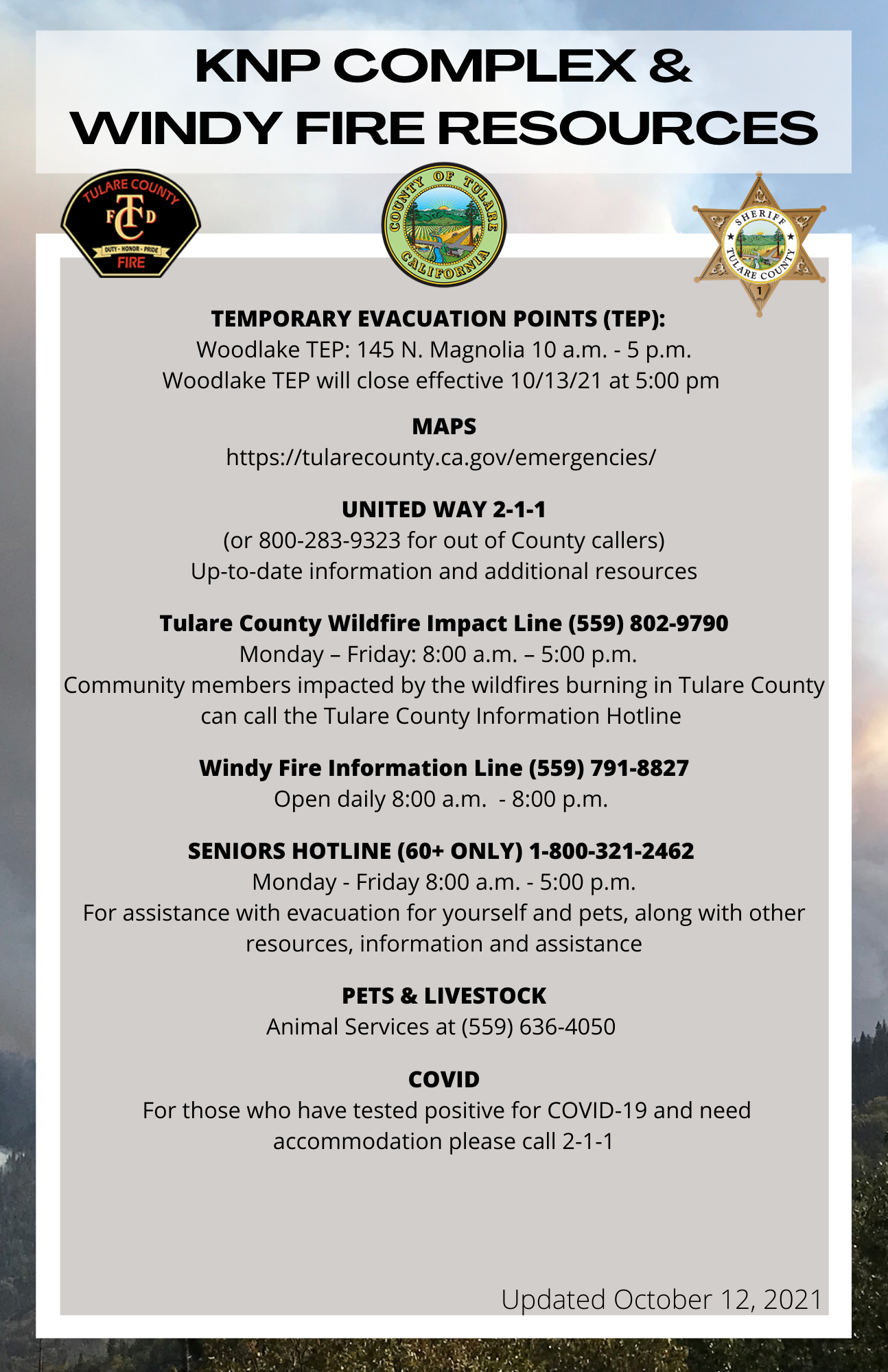
https://bit.ly/KNPComplexYTCounty of Tulare For Immediate Release Oct 12 2021
Related Incident: KNP Complex
Publication Type: Announcement
County of Tulare
For Immediate Release
Stuart Anderson, Public Information Officer October 12, 2021
County Announces Change to Temporary Evacuation Points and Senior Hotline Hours for KNP Complex and Windy Fires
VISALIA, CA – Effective at 5:00 pm tomorrow, Wednesday, October 13, 2021, the Woodlake Community Center temporary evacuation point (TEP) will cease operations. The Porterville College TEP ceased operations on October 11.
In addition to the TEP closures, the senior information and assistance hotline at 1-800-321- 2462 will be reduced to weekdays only, Monday through Friday, from 8:00 am to 5:00 pm. As a reminder, this hotline is for seniors 60+ only.
Please call 2-1-1 for information and resources. The county wildfire impact hotline at 559- 802-9790 will operate Monday through Friday from 8:00 am to 5:00 pm.
###
Actualizacin sobre las zonas Norte y Sur del complejo KNP 12 de octubre
Related Incident: KNP Complex
Publication Type: News
12 de octubre de 2021
Acres: 87,467 acres
Contención: 30 %
Fecha de inicio: 10 de septiembre de 2021
Causa: Rayos
Jurisdicción: Parques Nacionales Sequoia y Kings Canyon; Parque Nacional Sequoia
Recursos: 2,083 miembros del personal, 42 cuadrillas manuales, 130 vehículos de bomberos, 41 camiones cisterna, 11 buldóceres y 17 helicópteros
Zona Norte: La reducción de la visibilidad afectó ayer las actividades de extinción y la respuesta de las aeronaves. Cayó una nevada ligera en las elevaciones más altas y las temperaturas descendieron a 15 °F en algunas áreas. En anticipación del descenso de las temperaturas, la inestabilidad de los árboles y las ramas debilitadas, las cuadrillas se trasladaron a elevaciones más bajas y cálidas durante la noche. Se espera que concluya la conexión total de la línea de contención en la sección nororiental, entre Montecito Lodge y Stony Creek, en los próximos días. No se espera una propagación más allá de la huella actual del incendio, y las cuadrillas se centrarán en las actividades de neutralización y exploración. Los responsables del control del incendio esperan que los vientos más tranquilos y las condiciones más despejadas permitan realizar patrullas con sistemas de aeronaves no tripuladas sobre las áreas que resultan inaccesibles para las cuadrillas por las ramas rotas y quemadas. Las operaciones con drones proporcionarán una imagen más clara del impacto del fuego en las arboledas de secuoyas más grandes. Las cuadrillas nocturnas han sido reasignadas para apoyar a las operaciones diurnas.
Zona Sur: Ayer, la mayor parte del área del incendio recibió algo de precipitación, en la forma de lluvia o nieve. En las primeras horas de la mañana, antes de que llegara el viento, se utilizaron aeronaves para brindar protección en anticipación de cualquier propagación adicional. Se añadieron mas franjas libres de materiales combustibles en la zona sur, conectando el área al este de Sheep Ridge Wilderness hacia el sur, a lo largo del perímetro, hasta enlazarse con la franja al sur de Fry’s Point. La cuadrilla de élite insertada estratégicamente en el borde suroeste del perímetro del incendio y en la bifurcación este del río Kaweah sigue trabajando para completar la línea directa hacia el este. Este trabajo progresará a lo largo de los siguientes días. Las operaciones de retirada continúan en la parte occidental del incendio para retirar los lazos de manguera, las bombas y otros equipos excesivos que ya no son necesarios para apoyar las actividades de extinción. Continúa el trabajo difícil en el mantillo de Atwell Grove, con la construcción manual de una línea hacia el norte, hacia los accidentes geográficos naturales. Este trabajo garantizará tanto la protección de los árboles como la extinción de cualquier calor residual cerca del perímetro del incendio.
Condiciones meteorológicas: Hoy se esperan condiciones meteorológicas más secas, con temperaturas más cálidas que durarán hasta el fin de semana.
Seguridad: Siga respetando los cierres y reduzca la velocidad al viajar en o cerca del área del incendio. Tenga presente que las condiciones de los caminos pueden haberse deteriorado durante la noche por la precipitación en las elevaciones más altas.
Evacuaciones: Hay ÓRDENES y ADVERTENCIAS de evacuación vigentes. Para obtener la información más reciente, visite: https://nifc.maps.arcgis.com/apps/webappviewer/index.html?id=4b2ac27b5c8943ed92c0e77aa94daca0. Aprenda a prepararse para una evacuación visitando https://www.readyforwildfire.org/.
Cierres: Los Parques Nacionales Sequoia y Kings Canyon están cerrados al oeste de Pacific Crest Trail y al sur de la cordillera situada al norte de la cuenca Ionian. Además, el Área de Gestión Recreativa Extendida de la Oficina de Administración de Tierras en Case Mountain y grandes secciones del Bosque Nacional Sequoia también están cerradas. Vea los cierres en https://inciweb.nwcg.gov/incident/closures/7838/
Impactos de humo: Puede encontrar las actualizaciones sobre la calidad actual del aire en https://www.wildlandfiresmoke.net/outlooks/FresnoCA.
INFORMACIÓN SOBRE INCENDIOS
Zona Norte
PÚBLICO y MEDIOS DE COMUNICACIÓN: (559) 494-4881 (8:00 a. m. – 8:00 p. m.)
Zona Sur
PÚBLICO: (559) 492-9988 (8:00 a. m. – 8:00 p. m.); MEDIOS DE COMUNICACIÓN:(559) 492-9967
CORREO ELECTRÓNICO: 2021.KNP@firenet.gov
INCIWEB: https://inciweb.nwcg.gov/incident/7838/
FACEBOOK:
https://www.facebook.com/sequoiakingsnps/ y https://www.facebook.com/sequoiaNF/
TWITTER:
https://twitter.com/SequoiaKingsnps y https://twitter.com/sequoiaforest
INSTAGRAM:
https://www.instagram.com/Sequoiakingsnps
YOUTUBE:
https://bit.ly/KNPComplexYT