
KNP Complex Public MeetingOct 5 2021 Facebook Live
Related Incident: KNP Complex
Publication Type: Announcement
Please join us on Facebook for another Public Meeting tonight Tuesday, October 5 at 7:00 PM here is the link: Sequoia and Kings Canyon NPS Facebook Live
Tulare County Sheriff's Facebook Page Enter your Address Evacuation Map
As of October 4, 2021:
Sheriff Boudreaux has issued an evacuation order for the following residences in the Mineral King area, Gateway, to the Park Entrance including Sycamore Dr.
The area will include Mineral King Rd from Highway 198 to the Oak Grove Bridge, including Crest, Sierra King, Hammond, and Oak Grove. There will be a road closure at Highway 198 at Mineral King Rd.
The Evacuation Order will include: Mineral King Dr up to the Sequoia National Park Boundary, including associated structures along both sides of HWY 198 to the Park Boundary. Including, Oak Grove Bridge down to HWY 198, including Sierra King Dr, Crest Lane, Hammond Dr, Oak Grove Dr. Not including Dinely Dr.
Evacuation WARNINGS still remain in place for all structures from Old Three Rivers Rd and Blossom Dr to South Fork Dr, including South Fork Dr up HWY 198 to Mineral King Dr, including North Fork Dr, also including all side roads along HWY 198 to Mineral King Dr.
Please refer to https://tularecounty.ca.gov/emergencies/ KNP Complex Evacuation Area Map for more information. Tulare Co. Evacuation Area Map
Tulare County Emergency Notifications
Tulare County Sheriff's Office Facebook
Fresno County Sheriff's Office Facebook
Fresno County Evac Map County Resources for Evacuees
Individuals who may need assistance evacuating may call 2-1-1.
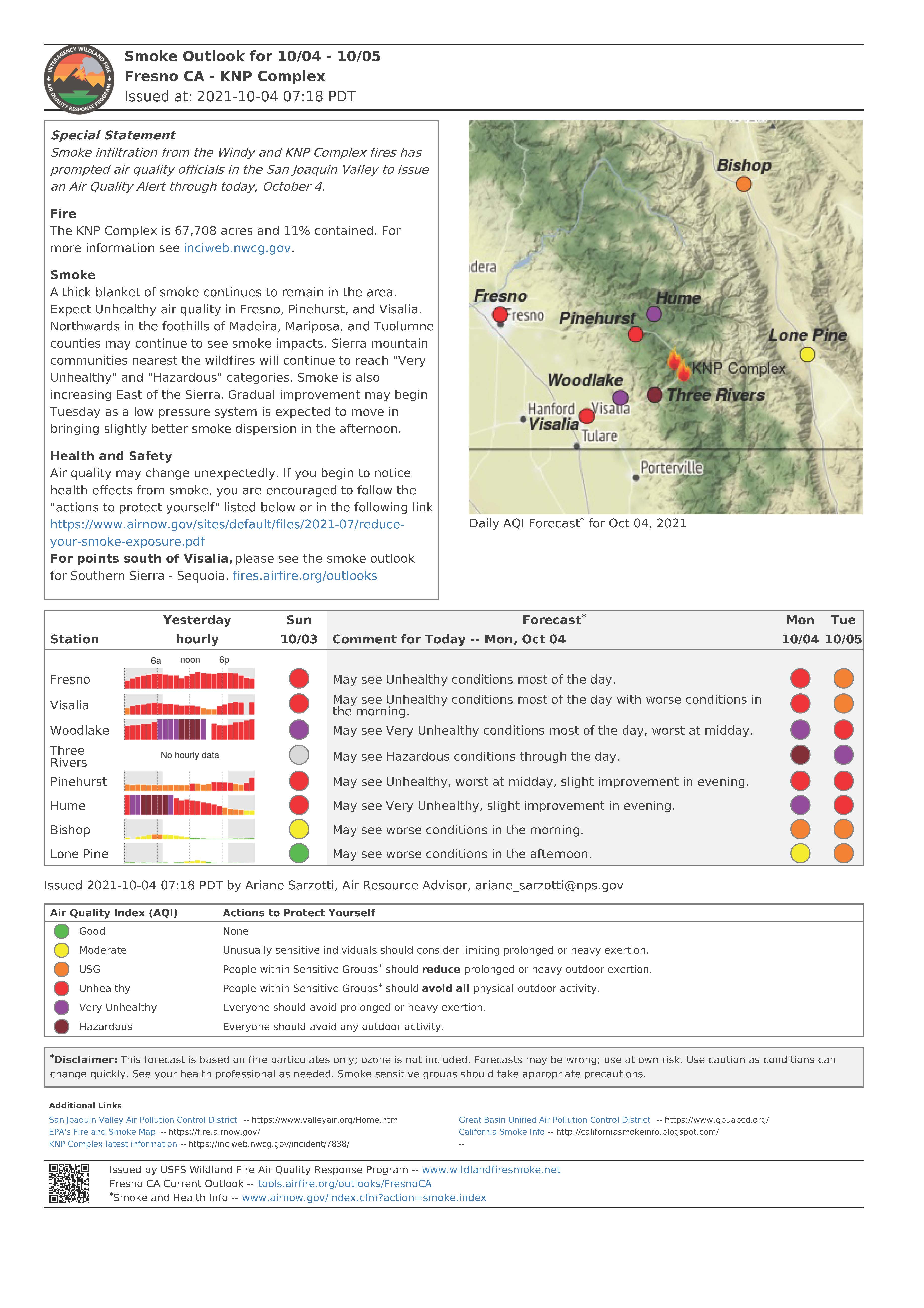
KNP Complex Update October 4 2021
Related Incident: KNP Complex
Publication Type: News
Southwest Area Type 1 Incident Management Team 2
Dave Bales – Incident Commander
Acres: 67,708 acres (based on infrared flight)
Containment: 11%
Start Date: September 10, 2021
Cause: Lightning
Jurisdiction: Sequoia and Kings Canyon National Park; Sequoia National Forest
Resources: 1,531 ¬personnel including: 26 crews, 61 engines, 40 water tenders, 21 dozers and 12 helicopters
Late last night winds caused a spot fire across Mineral King Rd which prompted an Evacuation Order for Crest, Sierra King, Hammond, and Oak Grove. Yesterday, firefighters continued with indirect suppression tactics to secure control lines on the northwest perimeter. Tactical firing operations are being used to create a continuous line between previously established control lines and existing or natural holding features such as roads and rock scurries. In Redwood Mountain Grove, crews worked in close coordination with natural resource specialists as they progressed with strategic firing operations in the northwest. Structure protection continues in Eshom, Hartland, Silver City and Mineral King areas.
Today, along Mineral King Rd firefighters will assess how to safely engage the spot fires that occurred last night. Resources will continue to provide structure protection for those communities under Evacuation Orders. Unmanned Aircraft Systems (UAS) will be used to help gather information along the southern perimeter. The fire continues to hold east of control lines on the western perimeter. Firefighters will continue to secure lines while maintaining a presence in the Three Rivers and Ash Mountain areas. Tactical firing operations will continue as conditions allow along the northwest flank as crews progress to the north. Firefighters in Redwood Mountain Grove are working in coordination with resource advisors to establish strategic plans for future tactical firing operations. UAS may assist firefighters with tactical firing operations as they progress north along Generals Highway. Minimal fire activity was observed near the northeast corner because the fire is burning in areas with less continuous fuels. Firefighters continue to secure and extinguish heat sources near established containment lines and within the Giant Forest Grove. Aviation resources are available to support firefighting efforts on the ground as visibility allows.
Containment decreased due to the increase in fire size. We ask the public to use caution when traveling in and around the fire area as firefighters and equipment are diligently working to protect communities and construct containment lines.
The high-pressure ridge that has held smoke over the fire over the past few days will begin to break down as a low-pressure trough approaches today. This will allow a small increase in westerly winds aloft which will start to lift smoke up and out of the area. Local winds will remain light and terrain driven. Humidity levels will rise slowly as moister air moves into the area, which will help moderate fire behavior slightly in the coming days.
Evacuation Orders and Warnings remain in effect. For all detailed KNP Complex evacuation information please visit: https://nifc.maps.arcgis.com/apps/webappviewer/index.html?id=4b2ac27b5c8943ed92c0e77aa94daca0
Information about how to prepare for evacuations can be found at https://www.readyforwildfire.org/.
Sequoia and Kings Canyon National Parks are closed west of the Pacific Crest Trail and south of the ridgeline which lies north of Ionian Basin. In addition, the BLM Case Mountain Extensive Recreation Management Area and major portions of the Sequoia National Forest are also closed.
Communities surrounding the park and in the nearby region are being affected by smoke and the resulting poor air quality. Track your local air quality at https://www.wildlandfiresmoke.net/outlooks/FresnoCA.
Fire Information:
PUBLIC: (559) 492-9988 (8 a.m. – 8 p.m.); MEDIA: (559) 492-9967
EMAIL: 2021.KNP@firenet.gov
INCIWEB: https://inciweb.nwcg.gov/incident/7838/
FACEBOOK:
https://www.facebook.com/sequoiakingsnps/
https://www.facebook.com/sequoiaNF/
INSTAGRAM:
https://www.instagram.com/Sequoiakingsnps
https://www.instagram/sequoianationalforest
TWITTER:
https://twitter.com/SequoiaKingsnps
https://twitter.com/sequoiaforest
NEW Evacuation Orders for Tulare CountyMineral King Rd Areas
Related Incident: KNP Complex
Publication Type: Announcement
MONDAY, OCTOBER 4, 2021
HAPPENING NOW: New Evacuation Orders Underway For KNP Complex Fire Tulare County Sheriff's Facebook Page Enter your Address Evacuation Map
Sheriff Boudreaux has issued an evacuation order for the following residences in the Mineral King area, Gateway, to the Park Entrance including Sycamore Dr.
The area will include Mineral King Rd from Highway 198 to the Oak Grove Bridge, including Crest, Sierra King, Hammond, and Oak Grove. There will be a road closure at Highway 198 at Mineral King Rd.
The Evacuation Order will include: Mineral King Dr up to the Sequoia National Park Boundary, including associated structures along both sides of HWY 198 to the Park Boundary. Including, Oak Grove Bridge down to HWY 198, including Sierra King Dr, Crest Lane, Hammond Dr, Oak Grove Dr. Not including Dinely Dr.
Evacuation WARNINGS still remain in place for all structures from Old Three Rivers Rd and Blossom Dr to South Fork Dr, including South Fork Dr up HWY 198 to Mineral King Dr, including North Fork Dr, also including all side roads along HWY 198 to Mineral King Dr.
Please refer to https://tularecounty.ca.gov/emergencies/ KNP Complex Evacuation Area Map for more information. Tulare Co. Evacuation Area Map
Tulare County Emergency Notifications
Tulare County Sheriff's Office Facebook
Fresno County Sheriff's Office Facebook
Fresno County Evac Map County Resources for Evacuees
Individuals who may need assistance evacuating may call 2-1-1.
KNP Complex Update October 3 2021
Related Incident: KNP Complex
Publication Type: News
Southwest Area Type 1 Incident Management Team 2
Dave Bales – Incident Commander
Acres: 62,761 acres (based on infrared flight) Containment: 20%
Start Date: September 10, 2021 Cause: Lightning
Jurisdiction: Sequoia and Kings Canyon National Parks, and Sequoia National Forest
Resources: 1,357 ¬personnel including: 26 crews, 61 engines, 40 water tenders, 21 dozers and 12 helicopters
Firefighters had another successful day because the smoke inversion kept fire activity from becoming extreme. Tactical firing operations continued along the northwest perimeter. Structure protection efforts are on-going for the communities of Eshom and Hartland. Crews on the northern flank progressed through Redwood Mountain Grove conducting firing operations to secure lines and minimize potential future fire impacts. Resources along Generals Highway progressed north to Cabin Creek with successful tactical firing operations as well.
Today, firefighters anticipate similar conditions depending on how weather and smoke lift out later in the day. Structure protection and tactical firing operations continue on the northwest corner of the fire. As conditions permit, crews will progress with tactical firing operations within the Redwood Mountain Grove and north of Cabin Creek along Generals Highway. Firefighters on the eastern flank continue securing the Giant Forest Grove while also supporting strategic firing operations to the north. On the southern perimeter, firefighters continue indirect suppression tactics improving Mineral King Rd. Resources are being shifted to the community of Silver City and the Mineral King area for structure protection as the fire continues to move south and east. Firefighters on the southwest edge remain in the communities of Three Rivers and Ash Mountain. Additional federal, state, and local resources are arriving, supporting firefighting efforts and being placed where needed. Aviation assets are available to support ground personnel as smoke and visibility permits.
Active fire behavior is expected as a ridge of high pressure remains over the fire bringing continued hot, dry, and smoky conditions. Humidity levels are expected to remain low while winds will continue to be light and terrain driven.
Evacuation orders and warnings remain in effect. Detailed KNP Complex evacuation information can be found at https://tularecounty.ca.gov/emergencies/ and https://www.facebook.com/FresnoSheriff.\. Information about how to prepare for evacuations can be found at https://www.readyforwildfire.org/.
Sequoia and Kings Canyon National Parks are closed west of the Pacific Crest Trail and south of the ridgeline which lies north of Ionian Basin. In addition, the BLM Case Mountain Extensive Recreation Management Area and major portions of the Sequoia National Forest are also closed.
Communities surrounding the park and in the nearby region are being affected by smoke and poor air quality. Track your local air quality at https://www.wildlandfiresmoke.net/outlooks/FresnoCA.
Fire Information:
PUBLIC: (559) 492-9988 (8 a.m. – 8 p.m.); MEDIA: (559) 492-9967
EMAIL: 2021.KNP@firenet.gov
INCIWEB: https://inciweb.nwcg.gov/incident/7838/
FACEBOOK:
https://www.facebook.com/sequoiakingsnps/ and https://www.facebook.com/sequoiaNF/
TWITTER:
https://twitter.com/SequoiaKingsnps and https://twitter.com/sequoiaforest
INSTAGRAM:
https://www.instagram.com/SequoiakingsnpsKNP Complex Update October 2 2021
Related Incident: KNP Complex
Publication Type: News
Southwest Area Type 1 Incident Management Team 2
Dave Bales – Incident Commander
Acres: 58,283 acres (based on infrared flight)
Containment: 20%
Start Date: September 10, 2021
Cause: Lightning
Jurisdiction: Sequoia and Kings Canyon National Parks
Resources: 1,345 personnel including: 26 crews, 61 engines, 40 water tenders, 21 dozers and 12 helicopters
Virtual Meeting Today at 7:00 PM streamed on Facebook Live https://www.facebook.com/SequoiaKingsNPS/live_videos
Yesterday, the northwest flank where the fire crossed the North Fork Kaweah River and the eastern perimeter near Castle Creek Grove experienced the most active fire behavior and new growth. Resources on the northern perimeter initiated successful tactical firing operations in the Redwood Mountain Grove, along the Generals Highway towards Dorst Campground and south of Eshom Point along northwest contingency lines as conditions were favorable. Throughout the night firefighters continued strategic firing operations to secure contingency lines. The fire has burned onto both Kings Canyon National Park and Sequoia National Forest.
Today, low-intensity tactical firing operations will progress within the Redwood Mountain Grove, along the Generals Highway and along northwest contingency lines south of Eshom Point if conditions are favorable. Resources will continue structure protection efforts in the communities of Eshom and Hartland by removing debris away from structures, setting up sprinklers and installing hose lays. Crews east of the Generals Highway along the northern perimeter will work to improve established containment lines working to the east. Firefighters on the eastern flank will continue securing the Giant Forest Grove while also supporting strategic firing operations to the north as needed. As additional resources arrive to the southern perimeter, they will continue with indirect suppression tactics along Mineral King Rd and scout for opportunities to safely engage the fire perimeter directly. The fire is expected to progress further south, down slope towards the road today. Firefighters remain in the communities of Three Rivers and Ash Mountain as an increase in fire behavior was observed yesterday. Along the western perimeter, an Unmanned Aircraft System (UAS) will be utilized to gather information which will be used to inform operational plans. Aircraft will support ground resources as air quality permits.
Humidity recovery was poor overnight and relative humidity levels are expected to remain low today. A ridge of high pressure remains over the fire bringing hot and dry conditions. Winds will be primarily terrain driven and are not expected to surface over the fire until mid-afternoon. Active fire behavior is expected again today.
Evacuation warnings and orders are still active. Areas currently under an evacuation warning are urged to be ready to mobilize and leave should the warning escalate to an evacuation order. Detailed evacuation information for Tulare County can be found at: https://tularecounty.ca.gov/emergencies/ and for Fresno County at: https://www.facebook.com/FresnoSheriff.
Sequoia and Kings Canyon National Parks are closed west of the Pacific Crest Trail and south of the ridgeline which lies north of Ionian Basin. In addition, the BLM Case Mountain Extensive Recreation Management Area and major portions of the Sequoia National Forest are also closed.
Communities surrounding the park and in the nearby region are being affected by smoke and the resulting poor air quality. Track your local air quality at https://www.wildlandfiresmoke.net/outlooks/FresnoCA.
Fire Information:
PUBLIC: (559) 492-9988 (8 a.m. – 8 p.m.); MEDIA: (559) 492-9967
EMAIL: 2021.KNP@firenet.gov
INCIWEB: https://inciweb.nwcg.gov/incident/7838/
FACEBOOK:
https://www.facebook.com/sequoiakingsnps/
https://www.facebook.com/sequoiaNF/
INSTAGRAM:
https://www.instagram.com/Sequoiakingsnps
https://www.instagram/sequoianationalforest
TWITTER:
https://twitter.com/SequoiaKingsnps
https://twitter.com/sequoiaforest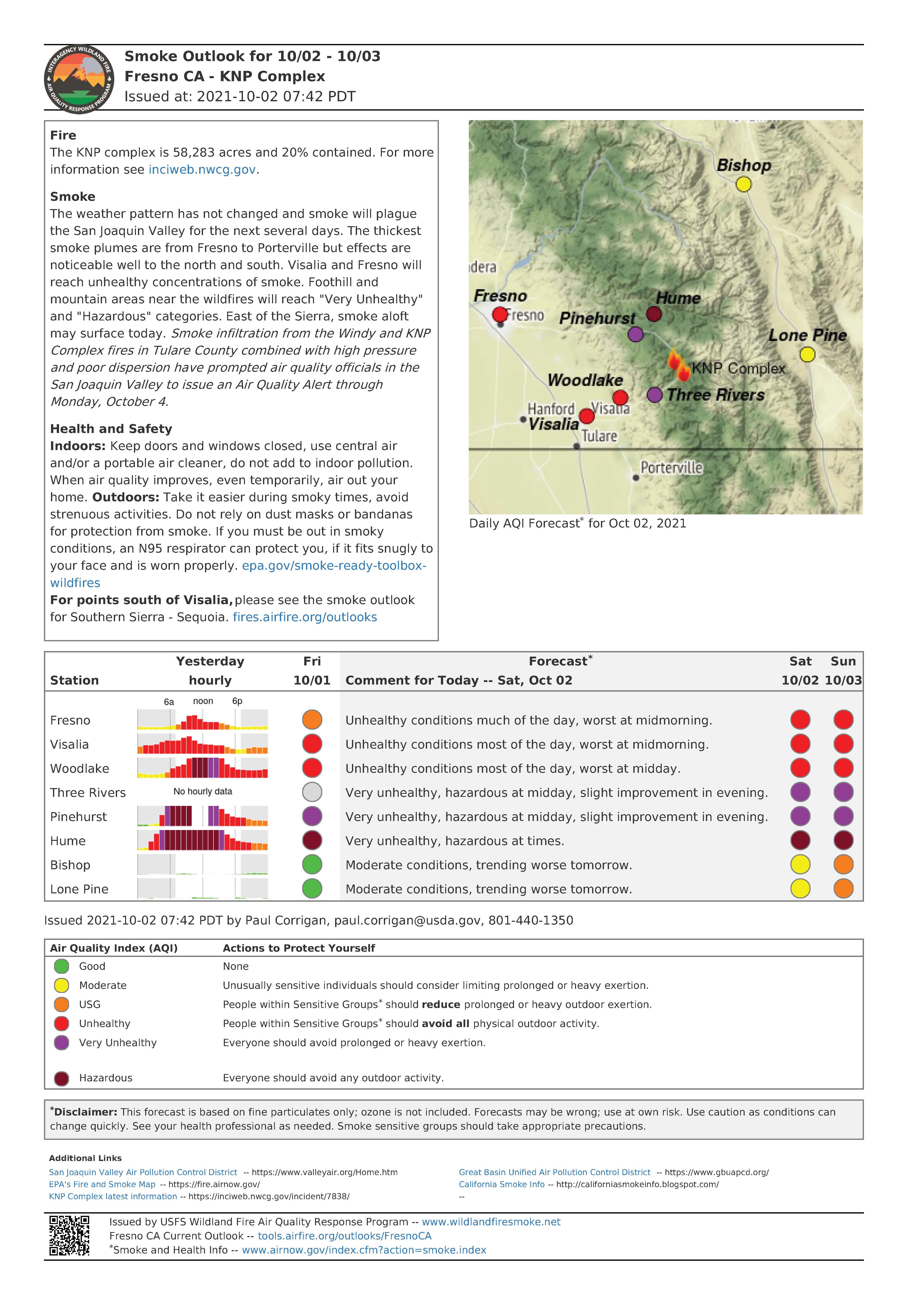
KNP Complex Update October 1 2021
Related Incident: KNP Complex
Publication Type: News
Sequoia & Kings Canyon NPS YouTube Channel
(View the recordings of the latest community meetings and daily operational updates here)
Southwest Area Type 1 Incident Management Team 2
Dave Bales – Incident Commander
Acres: 51,596 acres (based on infrared flight)
Containment: 20%
Start Date: September 10, 2021
Cause: Lightning
Jurisdiction: Sequoia and Kings Canyon National Park
Resources: 1,494 personnel including: 26 crews, 61 engines, 40 water tenders, 21 dozers and 12 helicopters
Yesterday, firefighters on the northwest corner saw an increase in fire behavior as weather conditions became hotter and drier throughout the day. The fire continued to back down towards North Fork Kaweah River until mid-afternoon when the fire spotted across the river. This prompted Evacuation Orders for the communities of Eshom and Hartland Camp. Evacuation Warnings were also issued for the community of Badger in Tulare County and the Miramonte and Pinehurst areas in Fresno County. Air tankers and helicopters worked the spot fire into the evening hours with retardant and water drops in an effort to slow the spread. Fire managers shifted available resources to the threatened communities to reinforce structure protection efforts. More resources continue to be ordered to support the incident.
Firefighters on the eastern flank were able to extend containment lines north from the Lodgepole campground area. Crews continued securing containment lines by extinguishing hotspots along the fireline and within the Giant Forest Grove. Unmanned Aircraft Systems (UAS) were utilized to gather information along the eastern perimeter near Middle Fork and south towards Mineral King Rd. Along the southern perimeter, additional fire crews continued improving the Mineral King Rd. as a holding feature, while also scouting for opportunities to engage the fire perimeter directly.
Today, resources will continue with structure protection in Eshom and Hartland as they work to gain direct access to the spot fire. Should the fire continue to spread north, firefighters may conduct tactical firing operations along the Generals Highway and within the Redwood Mountain Grove if conditions are favorable. Crews working on the northern flank of the fire, east of the Generals Highway, will be improving established containment lines while they progress east. On the southwestern flank, firefighters will continue to extinguish isolated sources of heat and maintain a presence in the communities of Three Rivers and Ash Mountain. Today, weather conditions will be similar to yesterday and an increase in fire activity can be expected. Aircraft will continue to support firefighters on the ground as visibility permits.
Evacuation Orders were reduced to a Warning for some residences in the Mineral King and Three Rivers areas yesterday afternoon and increased for Eshom and Hartland Camp. Evacuation Warnings were issued for Badger and the Miramonte and Pinehurst areas. Detailed evacuation information for Tulare County can be found at: https://tularecounty.ca.gov/emergencies/ and for Fresno County at: https://www.facebook.com/FresnoSheriff.
Media Advisory for October 1 2021
Related Incident: KNP Complex
Publication Type: News
A media tour to Sequoia and Kings Canyon National Parks will be held on Friday, October 1, 2021 at 11:00 a.m. The tour will include the Park Ridge Fire Lookout and Grant Grove of giant sequoias.
Participants should arrive at the Kings Canyon Visitor’s Center (83918 CA-180, Grant Grove Village, CA 93633) no later than 11:00 a.m.
The tour will provide opportunities to view areas of the National Parks affected by prior wildfire (Rough Fire in 2015) and highlight the benefits of prescribed fire and fuels management on the landscape.
This tour is open to all interested media outlets. Participants are not required to wear personal protective equipment (PPE) on this tour.
There will be not be opportunity on this media tour to view live fire.
The tour is expected to last approximately four hours. Participants will be required to remain with the group and escorts for the entire duration of the tour as the area is within a National Park Service closure area.
Meeting day/time: Friday October 1, 2021 at 11:00 a.m.
Meeting location: Kings Canyon Visitor’s Center (83918 CA-180, Grant Grove Village, CA 93633)
Announcements October 2 2021
Related Incident: KNP Complex
Publication Type: Announcement
Tulare County Emergency Notifications
Tulare County Sheriff's Office Facebook
Fresno County Sheriff's Office Facebook
Fresno County Evac Map County Resources for Evacuees
Individuals who may need assistance evacuating may call 2-1-1.
Older individuals (60+) who need assistance with evacuation or information may call the senior hotline at 1-800-321-2462.
AS OF OCTOBER 2, 2021
KNP Complex Fire Causes More Evacuation Warnings to Take Effect in Fresno County
Effective immediately, additional areas of Fresno County have had evacuation warnings placed. The specific zones are K88 and K89. Both of these zones are located north of the area that had previously been placed within a “Warning” status. The new areas under warnings include Sequoia Lake, Cedarbrook, Etheda Springs and Pinehurst.
Please use the following link to view a map of all zones in Fresno County.
AS OF OCTOBER 1, 2021
Sheriff to Downgrade Evacuation Orders for Some Areas Impacted by KNP Complex Fire
Effective at 2 p.m., Friday, Oct. 1, 2021, Sheriff Boudreaux will downgrade the Evacuation Order to Evacuation Warning for residences along Sierra Drive (Highway 198) from Mineral King Road, north to the entrance to Sequoia National Park, including the residences on Sycamore Drive. The area will include all structures, residential and businesses.
At this time, only residents and business owners are permitted to return.
Residents living in these areas may return to their homes after showing proof of residence to law enforcement officers. Proper documentation must include the person’s name and address within the impacted area. Examples include a driver’s license, utility bill or address documentation from the U.S. Post Office for people who use a post office box.
Evacuation warnings are voluntary. Community members are strongly encouraged to prepare to evacuate if it becomes necessary. If individuals feel they need more time, please consider leaving the area now.
The National Park Service will maintain a road closure at the park entrance. Sequoia and Kings Canyon National Park will remain closed. Sequoia and Kings Canyon National Park remains closed to the public.
Prior evacuation orders and warnings not addressed here will remain in effect.
Due to the current fire activity, fire personnel and equipment will continue to travel throughout the area. The Tulare County Sheriff’s Office encourages residents to be mindful of the additional traffic along Highway 198 and expect delays due to the slow-moving vehicles and to plan accordingly.
Teresa Douglass
Tulare County Sheriff’s Office
Public Information Officer
(559) 802-9412 office
(559) 731-7500 cell
ALSO AS OF OCTOBER 01, 2021
Sheriff Issues NEW Evacuation Orders for the KNP Complex Fire
Sheriff Boudreaux has issued EVACUATION ORDERS for the communities of Big Meadows, Weston Meadows, and Quail Flat in the Giant Sequoia National Monument, and the National Park Service has issued EVACUATION ORDERS for all residents, employees, and cooperators in the Grant Grove, Wilsonia, and Cedar Grove communities of Kings Canyon National Park. All non-fire related persons are required to leave those areas by 2 p.m. today, Oct. 1, 2021.
Please use Highway 180 westbound to evacuate the area.
An evacuation order means an immediate threat to life, safety, and property and all residents and visitors must leave now before the fire reaches the community. If you need assistance with evacuation, please call 9-1-1.
The temporary evacuation point, where you may find information and assistance is at the Woodlake Community Center at 145 N. Magnolia. Individuals with RVs/Trailers may find information about where they can park at the College, or you may go to the International Agri-Center 4500 W. Laspina in Tulare, Gate D, where you may dry camp.
When preparing to evacuate, please consider bringing important documents, necessary medication, changes of clothing, and hygiene items. If you are able to evacuate your domestic animals, remember to pack food, leashes, and other items. If you are not able to plan to evacuate your domestic animals or livestock, please make arrangements with Tulare County Animal Services prior to transporting your animals to an available shelter location by completing the Fire Assistance Evacuation Form located on the Tulare County Animal Services website at: https://tcanimalservices.org/animalservices/resources/animal-evacuation-form/?fbclid=IwAR1g1wCuXH6-jeD-WUjK4133AQLb3iwvJX8BvvX_3gL0pfcPj36QZ-Ou0n4.
All evacuation orders and warnings remain in effect for the KNP Complex Fire.
ALSO AS OF OCTOBER 1, 2021: Fresno County Sheriff's Office FB
KNP Complex Fire Triggers First Evacuation Warning for Fresno County
Effective immediately, an evacuation warning is in place for residents in the Miramonte / Pinehurst area. The specific zone is K159. The eastern and southern boundaries of this zone are the county line on both sides. The northern boundary includes the southern portion of the Giant Sequoia National Monument. The northern boundary is north of 52051 and 52170 Hogback Road. The western boundary is west of Highway 245 and includes properties accessible via Highway 245. Please use the following link to view a map of all zones in Fresno County. https://cofgisonline.maps.arcgis.com/.../index.html.
ALSO AS OF SEPTEMBER 30, 2021:
Sheriff Issues NEW Evacuation Orders, Warnings for the KNP Complex Fire
Sheriff Boudreaux has issued EVACUATION ORDERS for the communities of Eshom and Hartland Camp, including Eshom Valley Drive, from Fresno County Line, South to Tarbell Pocket on Eshom Valley Drive, and North Mountain Road, 468 North to the County line. The evacuation order includes all structures, side roads, associated roads, and forest service roads, due to the KNP Complex Fire.
To evacuate, please use Eshom Valley to Stage Coach, to Highway 245 or Dry Creek.
An evacuation order means an immediate threat to life, safety, and property and all residents and visitors must leave now before the fire reaches the community. If you need assistance with evacuation, please call 9-1-1.
A road closure is in effect at Eshom Valley Road and Stage Coach.
An EVACUATION WARNING has been issued for the community of Badger to the North Tulare County Boundary, including Whittaker Forest Road, Hogback Road, CA 245, Dry Creek, Sierra Glenn, all the way to Wild Hog Canyon. Then South to Deep trail, Shadley Jeep Trail. Then East to Eshom Valley Road and North to the Tulare County Boundary. Including all structures, side roads, associated roads, and forest service roads.
Evacuation warnings are voluntary. Community members are strongly encouraged to prepare to evacuate if it becomes necessary. If individuals feel they need more time, please consider leaving the area now.
The temporary evacuation point, where you may find information and assistance is at the Woodlake Community Center at 145 N. Magnolia. Individuals with RVs/Trailers may find information about where they can park at the College, or you may go to the International Agri-Center 4500 W. Laspina in Tulare, Gate D, where you may dry camp.
When preparing to evacuate, please consider bringing important documents, necessary medication, changes of clothing, and hygiene items. If you are able to evacuate your domestic animals, remember to pack food, leashes, and other items. If you are not able to plan to evacuate your domestic animals or livestock, please make arrangements with Tulare County Animal Services prior to transporting your animals to an available shelter location by completing the Fire Assistance Evacuation Form located on the Tulare County Animal Services website at: https://tcanimalservices.org/.../animal-evacuation-form/....
All evacuation orders and warnings remain in effect for the KNP Complex Fire.
Please refer to https://tularecounty.ca.gov/emergencies/ for the Windy Fire Evacuation Warning Area Map. Call 2-1-1 for more information. Log on to https://inciweb.nwcg.gov/incident/7841/ for incident information.
#tularecounty
#tularecountysheriff
#tcso
#knpcomplex
#knpcomplexfire
Media Advisory 9302021
Related Incident: KNP Complex
Publication Type: News
Media Information Line: 559-492-9967
Pool Tour to the Giant Forest / KNP Complex Fire
Due to high demand and safety concerns, i.e., COVID-19 and the conditions of the of the Generals Highway, the media tour to the Giant Forest will employ a pool media coverage plan.
Media outlets in attendance will be expected to pool or share their coverage with any outlets that request it.
The itinerary entails taking the tour participants to the Giant Forest, and if time allows, other notable park areas along the Generals Highway that have been impacted by the KNP Complex.
Safety is a priority due to hazard trees that have been weakened by the fire. The tour escorts reserve the right to detour, cancel, or shorten the tour at any time due to safety concerns.
Media outlets participating in the tour today include:
• ABC 30 News/Fresno
o Jacqueline McLean, 559-304-5168
• The Fresno Bee
o Eric Zamora, 559-903-7256
• The Sun Gazette (based in Exeter, CA)
o Zach Green, 559-280-5821
Any media outlets interested in the content from this Giant Forest tour should directly contact the outlets listed above to gain access to their content. Media outlets interested in carpooling should also contact the individuals listed above.
Due to limited connectivity at the location of the tour, access to content may be delayed until the team is in a location where video can be uploaded.KNP Complex Update September 30 2021
Related Incident: KNP Complex
Publication Type: News
Southwest Area Type 1 Incident Management Team 2
Dave Bales – Incident Commander
Acres: 49,349 acres
Containment: 11%
Start Date: September 10, 2021
Cause: Lightning
Jurisdiction: Sequoia and Kings Canyon National Parks
Resources: 1,949 personnel including: 53 crews, 78 engines, 44 water tenders, 35 dozers and 17 helicopters
Yesterday, fire activity was minimal in most areas along the perimeter. Firefighters continued to scout and construct direct line, strengthen and hold existing lines, monitor the perimeter and work on contingency lines. As smoke and conditions allowed, helicopters conducted buckets drops on isolated pockets of heat, slowing fire spread on the western perimeter, in the Pine Grove area, and the east side of Generals Highway. Crews constructed containment line north of Lodgepole, and structure protection groups continued to shore up protections for local communities.
Today, a drying weather trend is expected to increase fire activity. Structure protection groups will remain positioned to focus on and protect local communities including Three Rivers, Hartland and Ash Mountain, the giant sequoia groves, historic buildings and other infrastructure. Helicopters are available to conduct bucket drops to support firefighters on the ground. Crews continue to work along Mineral King Road in anticipation of increased fire activity and look for opportunities to safely construct direct line north of Mineral King Road. Firefighters continue to prep and protect the Giant Forest, Muir, Lost, and Redwood sequoia groves.
There have been no new evacuation Warnings or Orders for the KNP Complex in the past 24 hours. All evacuation warnings and orders that that have been issued are still active. Areas currently under an evacuation warning are urged to be ready to mobilize and leave should the warning escalate to an evacuation order. Explore a map of the areas under a warning or order at www.tularecounty.ca.gov/emergencies. A Red Cross evacuation center is located at the Woodlake Community Center at 145 Magnolia St, Woodlake, CA.
Sequoia and Kings Canyon National Parks are closed west of the Pacific Crest Trail and south of the ridgeline which lies north of Ionian Basin. In addition, the BLM Case Mountain Extensive Recreation Management Area and major portions of the Sequoia National Forest are also closed.
Communities surrounding the park and in the nearby region are being affected by smoke and the resulting poor air quality. Track your local air quality at https://www.wildlandfiresmoke.net/outlooks/FresnoCA.
Wildfires are a No Drone Zone. IF YOU FLY, WE CAN’T. Every time a drone is spotted near the fire all firefighting aircraft are grounded until we can be sure the drone is clear of this area. More info visit: http:/knowbeforeyoufly.org.
FIRE INFORMATION:
PUBLIC: (559) 492-9988 (8 a.m. to 8 p.m.); MEDIA: (559) 492-9967 (8 a.m. to 8 p.m.); EMAIL: 2021.KNP@firenet.gov
To receive email updates on the KNP Complex, text KNP to 22828
InciWeb: inciweb.nwcg.gov/incident/7838/
Facebook/Twitter/Instagram: @SequoiaKingsNPS