
Yogi Fire Final Update 061522 730am
Related Incident: Yogi Fire
Publication Type: Announcement
Yogi Fire Final Update 06/15/2022 7:30am
Size: 123 acres
Containment: 95%
Cause: Debris Burning
The Yogi Fire is now at 123 acres due to more accurate mapping with 95% containment. This fire is transitioning to monitor and patrol status to ensure no holding issues occur. The fire will be staffed by engine crews, The Elk Creek Mod, and local resources today. On Tuesday, crews made good progress mopping up heat and felling trees that could pose a risk to falling over containment lines. Resources were pulled from the Yogi Fire Tuesday afternoon to the Abbey Knob Fire in Bastrop County, which has now been contained at 1.83 acres. Heavy mop up will continue to ensure hot spots are extinguished on Wednesday. An IR drone flight will be conducted on Thursday to check for hidden heat in the fire that could threaten containment.
Good humidity recovery overnight will linger into this morning. In the afternoon clouds will clear and fire weather will return. High will be near 98 with heat index values of 102.
Yogi Fire Update 730am 06142022
Related Incident: Yogi Fire
Publication Type: Announcement
Yogi Fire Update 06/14/2022 7:30am
Size: 100 acres
Containment: 85%
Cause: Debris Burning
Containment on the Yogi Fire has grown to 85% and acreage has grown to 100 due to better mapping from aircraft using GPS, the fire has not progressed since the previous update. During assessments last night a second outbuilding was confirmed lost making the total non-residential structures lost 2. The fire was staffed overnight with local resources, and unified command with State resources will continue today. The fire will be staffed today with TAMFS heavy equipment and engines from Smithville, San Angelo, local fire departments, and a hand crew from the Elk Creek Suppression Module (Colorado).
Plans for the next operational period are to hold and improve containment lines and mitigate hazard trees near the line using heavy equipment. Aircraft will be used when necessary for reconnaissance flights and suppression. Engines and the hand crew mod will perform heavy mop up operations to mitigate hot spots in the fire perimeter.
Fire danger will be high Tuesday. A breezy, hot, and dry afternoon is expected. Morning clouds will give way to afternoon sunshine. Relative humidity values should remain above 25% but winds will be quite gusty today, out of the SSE at 10-20 mph, gusting 25-30 mph at times.
Yogi Fire Update 750pm 06132022
Related Incident: Yogi Fire
Publication Type: Announcement
Yogi Fire Update 06/13/2022 7:50pm
Size: 50 acres
Containment: 75%
Cause: Debris Burning
Crews continue to build and improve containment lines on the Yogi Fire. Forward progression has been stopped. Containment has been upgraded to 75% with acreage remaining at 50. Aviation resources have been released for the night. 22 structures were directly threatened and saved and 1 outbuilding was lost. The cause of the Yogi Fire was debris burning. Evacuations were lifted at 4:30 pm, however, expect smoke and emergency vehicle presence in the burn area overnight. Please use caution in the area, and avoid unnecessary travel in the vicinity while crews continue to work.
Crews will continue to staff the Yogi Fire overnight and Tuesday to patrol containment lines and perform heavy mop up operations. Elevated to critical fire weather is forecasted the remainder of the week.
Yogi Fire Update 435pm 06132022
Related Incident: Yogi Fire
Publication Type: Announcement
Yogi Fire Update 06/13/2022 4:35pm
Size: 50 acres
Containment: 50%
Cause: Debris Burning
All evacuations have been lifted for the affected area, and power has been restored. Containment has increased to 50% and acreage remains estimated at 50 acres until better mapping can be complete. TAMFS remains in unified command with local fire departments. Aircraft including single-engine air tankers, and a type 1 helicopter have been used to slow the fire rate of spread while heavy equipment constructs containment lines.
For up to date information about evacuation centers and closures, and maps please visit the Bastrop County Office of Emergency Management Facebook page link below:
https://www.facebook.com/BastropCountyOEM
Weather: Fire weather conditions will be elevated this afternoon and early evening with humidity as low as 28% and winds 10 to 13 mph. Breezy
southerly winds will continue overnight bringing excellent moisture recovery. Tuesday will be just a bit cooler and this will
keep humidity in the low 30s%. Winds will continue to be an issue at 10 to 15 mph with gusts up to 25 mph from the south. Little change for the rest of the week.
Yogi Fire Update 310pm 06132022
Related Incident: Yogi Fire
Publication Type: Announcement
Yogi Fire Update 06/13/2022 3:10pm
Size: 50 acres
Containment: 25%
Cause: Unknown
Evacuations and closures are in the impacted area of Gotier Trace, South Old Potato and Old Pin Oak, and to Lois Lane.
For up to date information about evacuation centers and closures, and maps please visit the Bastrop County Office of Emergency Management Facebook page link below:
https://www.facebook.com/BastropCountyOEM
The Texas A&M Forest Service was requested to the Yogi fire for assistance shortly after 1pm on Monday, June 13th. Fire behavior was moderate, with low to moderate rate of spread when crews arrived on scene. TAMFS heavy equipment, aircraft, fire engines, and personnel are assisting local crews with suppression.
Weather: Fire weather conditions will be elevated this afternoon and early evening with humidity as low as 28% and winds 10 to 13 mph. Breezy
southerly winds will continue overnight bringing excellent moisture recovery. Tuesday will be just a bit cooler and this will
keep humidity in the low 30s%. Winds will continue to be an issue at 10 to 15 mph with gusts up to 25 mph from the south. Little change for the rest of the week.
Pipeline Fire continues burning north of Flagstaff
Related Incident: Double Fire
Publication Type: News
Strong winds continue to move the Pipeline Fire toward the northeast, as two additional wildfires the Haywire Fire and Double Fire are reported about 6 miles further ahead.
The exact size the the Pipeline Fire is unknown due to the inability for an overnight infrared flight. However, fire managers estimate the fire to be about 5,000 acres currently. Firefighters are working to suppress and keep fire from entering areas near communities, while deflecting the fire along the San Francisco Peaks toward the northeast as it enters some of the 2010 Schultz Fire and recent Tunnel Fire burn scars.
Strong winds coupled with warm weather have been the challeging factor for firefighters and air resources, as winds are predicted to be 40-50 mph today. The Coconino NF remains in Stage 2 fire and smoking restrictions. Information regarding fire restrictions can be found online at coconinonationalforest.us
PIPELINE FIRE
- Incident information site: https://inciweb.nwcg.gov/incident/8152/
- Size: Estimated at 5,000 acres
- Containment: 0%
- Location: 6 miles north of Flagstaff (35.281667, -111.681389)
- Date reported: June 12, 2022 at 10:15 a.m.
- Cause: Unknown and under investigation
- Current resources: 11 engines, three water tenders, three Hotshot crews, one hand crew, four dozers, various aerial resources and miscellaneous overhead.
- Closures: The Coconino National Forest has closed nearly the entire northern portion of the forest from Interstate 40 toward the north. View the Closure Order and map here.
- Smoke impacts: Smoke will impact areas of Doney Park and homesteads northeast of Doney Park, including Navajo Nation.
- Evacuations: Coconino County Sheriff's Office is the authorizing and approving agency for evacuation notices, which works with Coconino County Emergency Management to post information about evacuations and which areas are in Ready, Set, or Go status. To view these areas, visit the County's Emergency Management page.
- Injuries: None.
HAYWIRE FIRE
- Incident information site: https://inciweb.nwcg.gov/incident/8155/
- Size: Estimated at 1,600 acres; Will likely combine with Double Fire.
- Containment: 0%
- Location: 7.5 miles northeast of Doney Park (35.371667, -111.433372)
- Date reported: June 12, 2022 at 4:13 p.m.
- Cause: Unknown and under investigation but suspected as originating from a lightning strike from a storm days prior.
- Current resources: 10 engines. Multiple dozers have been ordered.
- Closures: The Coconino National Forest has closed nearly the entire northern portion of the forest from Interstate 40 toward the north. View the Closure Order and map here. Additionally, Arizona Department of Transportation has closed a portion of Highway 89, which restricts vehicles from traveling north and south in the area of the fire. Check www.az511.comfor status updates.
- Smoke impacts: Smoke will impact homesteads northeast of the fire, including Navajo Nation.
- Evacuations: Coconino County Sheriff's Office is the authorizing and approving agency for evacuation notices, which works with Coconino County Emergency Management to post information about evacuations and which areas are in Ready, Set, or Go status. To view these areas, visit the County's Emergency Management page.
- Injuries: None.
DOUBLE FIRE
- Incident information site: https://inciweb.nwcg.gov/incident/8155/
- Size: Estimated at 500 acres
- Containment: 0%
- Location: 2 miles south/southwest of the origin of the Haywire Fire (35.345842, -111.451177)
- Date reported: June 12, 2022 at 4:13 p.m.
- Cause: Unknown and under investigation but suspected as originating from a lightning strike from a storm days prior.
- Current resources: Part of the Haywire Fire resources responding.
- Closures: The Coconino National Forest has closed nearly the entire northern portion of the forest from Interstate 40 toward the north. View the Closure Order and map here. Additionally, Arizona Department of Transportation has closed a portion of Highway 89, which restricts vehicles from traveling north and south in the area of the fire. Check www.az511.com for status updates.
- Smoke impacts: Smoke will impact homesteads northeast of the fire, including Navajo Nation.
- Evacuations: Coconino County Sheriff's Office is the authorizing and approving agency for evacuation notices, which works with Coconino County Emergency Management to post information about evacuations and which areas are in Ready, Set, or Go status. To view these areas, visit the County's Emergency Management page.
- Injuries: None.
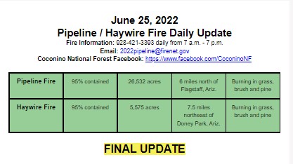
FINAL Update Haywire Fire June 25
Related Incident: Haywire Fire
Publication Type: News
FINAL UPDATE
Fire behavior
Monsoonal storms will continue to develop and pass through the area into next week, bringing the possibility of lightning and isolated heavy precipitation around the fire area. Showers and thunderstorms with the potential to produce flash flooding and debris flows off the Pipeline Fire scar, as well as the Tunnel and Museum fire scars, may occur. Cloud cover, high relative humidity, and precipitation will continue minimize fire behavior. Heat and smoke will still be present within the fire perimeter as interior pockets continue to burn unconsumed fuels.
Pipeline Fire
Minimal fire growth occurred last night and as containment continues to increase, firefighters will shift focus to suppression repair to minimizing potential soil erosion and impacts resulting from fire suppression activities. These activities will help aid in mitigating impacts to incoming precipitation. In containment areas, suppression repair is taking place along constructed dozer lines, as well as roads and trails that were used as fireline. On the southwest edge from Fremont peak running north toward the Inner Basin Trailhead, crews are monitoring fire progression and will engage as necessary.
Some heat and smoke are still occurring within the fire perimeter and firefighters and aviation resources continue to assess and take action to extinguish when necessary. Day and night shift initial attack groups stand ready to quickly respond to any spotting over the line or new starts caused by the incoming thunderstorms.
Haywire Fire
Minimal heat was detected across the fire yesterday and negligible growth occurred. Favorable conditions allowed additional containment to be gained around the southwestern perimeter of the fire. Crews will continue to monitor and patrol containment lines. Firefighters continue to secure the southern edge of the fire, extinguishing hotspots within the interior and patrolling and monitoring for areas that could potentially cause a threat to established fireline.
Evacuations, road and trail closures, and restrictions
Highway 89 is now open. An area closure is in place on the Coconino National Forest for the Pipeline Fire. For full descriptions of road closures and fire restrictions go to: www.fs.usda.gov/coconino/.
The Coconino County Sheriff's Office has lifted all evacuations. Evacuation information can be found at bit.ly/Pipeline-Haywire-Evacs.
Total fire resources assigned
- Roughly 348 personnel, including: three Hotshot crews, four hand crews, 19 engines, four water tenders and five helicopters
InciWeb: Pipeline Fire: https://inciweb.nwcg.gov/incident/8152/
Haywire Fire: https://inciweb.nwcg.gov/incident/8155/
Air quality: https://azdeq.gov/node/8262
Twitter: @CoconinoNF
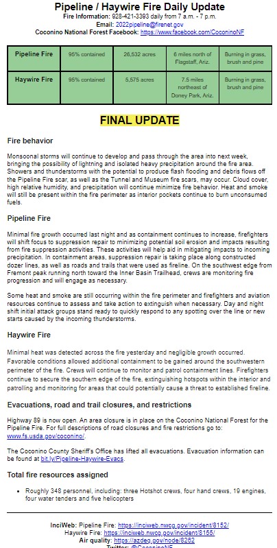
June 24 2022 PipelineHaywire Fire Daily Update
Related Incident: Haywire Fire
Publication Type: News
Fire behavior
Monsoonal storms will continue to develop and pass through the area into next week, bringing the possibility of lightning and isolated heavy precipitation around the fire area. Showers and thunderstorms with the potential to produce flash flooding and debris flows off the Pipeline Fire scar, as well as the Tunnel and Museum fire scars, may occur. Cloud cover, high relative humidity, and precipitation will continue minimize fire behavior. Heat and smoke will still be present within the fire perimeter as interior pockets continue to burn unconsumed fuels.
Pipeline Fire
Minimal fire growth occurred last night. As containment continues to increase, firefighters will shift focus to suppression repair to minimizing potential soil erosion and impacts resulting from fire suppression activities. These activities will help aid in mitigating impacts to incoming precipitation. In containment areas, suppression repair is taking place along constructed dozer lines, as well as roads and trails that were used as fireline. On the southwest
edge from Fremont peak running north toward the Inner Basin Trailhead, crews are monitoring fire progression and will engage as necessary.
Some heat and smoke are still occurring within the fire perimeter and firefighters and aviation resources continue to assess and take action to extinguish when necessary. Day and night shift initial attack groups stand ready to quickly respond to any spotting over the line or new starts caused by the incoming thunderstorms.
Haywire Fire
Minimal heat was detected across the fire yesterday and negligible growth occurred. Favorable conditions allowed for the gain of additional containment around the southwestern perimeter of the fire. Crews will continue to monitor and patrol containment lines. Firefighters continue to secure the southern edge of the fire, extinguishing hotspots within the interior and patrolling and monitoring for areas that could potentially cause a threat to established fireline.
Evacuations, road and trail closures, and restrictions
Highway 89 is now open. An area closure is in place on the Coconino National Forest for the Pipeline Fire. For full descriptions of road closures and fire restrictions go to: www.fs.usda.gov/coconino/. Evacuation information can be found at bit.ly/Pipeline-Haywire-Evacs.
Total fire resources assigned
- Roughly 494 personnel, including: three hand crews, 47 engines, five water tenders, one dozer and four helicopters
InciWeb: Pipeline Fire: https://inciweb.nwcg.gov/incident/8152/
Haywire Fire: https://inciweb.nwcg.gov/incident/8155/
Air quality: https://azdeq.gov/node/8262
Twitter: @CoconinoNF
June 23 2022 PipelineHaywire Fire Daily Update
Related Incident: Haywire Fire
Publication Type: News
Fire behavior
Some monsoonal moisture was received across both fire perimeters yesterday but did not bring noteworthy rain. However, thunderstorms are expected to progress throughout the week, bringing more rain to the area.
With the present cloud cover, higher humidity and cooler temperatures, conditions are not expected to support fire spread. Some smoke may still be visible as large, heavy fuels continue to burn within the perimeter, but smoke is not expected to decrease air quality to a significant degree.
Pipeline Fire
With current weather and fire behavior conditions, suppression repair remains the focus of operations and will resume today. Dozer lines will be repaired from the south to east edge of the fire up toward the Highway 89 corridor. Moving along the western edge toward the north, firefighters will continue to rehabilitate the existing trail system that was used as fireline around the Fremont Peak area. Chipping operations and road repair continue on the containment line on north perimeter. Air resources were able to assess both fire perimeters yesterday and will remain ready to respond as needed. A Burned Area Emergency Response (BAER) Team has responded to the incident and is assessing erosion stabilization issues to minimize potential threats to life and property resulting from the effects of fire suppression activities.
With the incoming thunderstorm activity anticipated, the Initial Attack group will remain poised to quickly respond to any spotting over the line or new starts near the fire area to minimize increasing fire growth. The fire is still being monitored and patrolled to detect and extinguish hotspots where possible and firefighters are working diligently to address safety concerns. Work continues to eventually regain access to closed areas resulting from fire activity.
Haywire Fire
Crews gained additional containment in the eastern perimeter of the fire yesterday, and crews will continue to monitor and patrol containment lines today. Suppression repair continues and firefighters will be using a road grader to rehabilitate roads that were used in fire suppression activities. Similar to yesterday, firefighters are focused on the southeast edge, continuing to secure the edge of the fire.
Evacuations, road and trail closures, and restrictions
Highway 89 is now open. An area closure is in place on the Coconino National Forest for the Pipeline Fire. For full descriptions of road closures and fire restrictions go to: www.fs.usda.gov/coconino/. Evacuation information can be found at bit.ly/Pipeline-Haywire-Evacs.
Total fire resources assigned
- Roughly 614 personnel, including: six Hotshot crews, nine hand crews, 36 engines, seven water tenders, four dozers and five helicopters
June 22 2022 PipelineHaywire Fire Daily Update
Related Incident: Haywire Fire
Publication Type: News
Fire Behavior
An increased chance of monsoonal moisture will occur in the fire area today and last into next week, bringing an increase in cloud cover and relative humidity.
Showers and thunderstorms with the potential to produce flash flooding and debris flows off the Pipeline Fire scar, as well as the Tunnel and Museum fire scars, may occur. Higher relative humidity will minimize fire behavior. Heat and smoke will still be present within the fire perimeter as interior pockets continue to burn unconsumed fuels.
Pipeline Fire
Minimal fire growth occurred last night. As containment continues to increase, firefighters will shift focus to suppression repair, and minimizing potential soil erosion and impacts resulting from fire suppression activities. These activities will help aid in mitigating impacts to predicted incoming precipitation. In containment areas, suppression repair will take place along constructed dozer lines, as well as roads and trails that were used as fireline. These activities are occurring at the southern edge of the fire near the Timberline community and the northern edge that runs from the Strawberry Crater area toward the powerline corridor where heavy equipment is being used. On the southwest edge from Fremont Peak running north toward the Inner Basin Trailhead, crews are monitoring fire progression and will engage as necessary.
Some heat and smoke are still occurring within the fire perimeter and firefighter and aviation resources continue to assess and take action to extinguish when necessary and where possible. Crews will continue to take advantage of the conditions to perform suppression repair and address hot spots. Day and night shift initial attack groups stand ready to quickly respond to any spotting over the line or new starts caused by the incoming thunderstorms.
Haywire Fire
Minimal heat was detected across the fire yesterday and negligible growth occured. Favorable conditions allowed for the gain of additional containment in the northwestern perimeter of the fire. Crews will continue to monitor and patrol containment lines. Firefighters continue to secure the southern edge of the fire, and will extinguish hotspots within the interior in addition to patrolling and monitoring for areas that could potentially cause a threat to established fireline.
Evacuations, road and trail closures, and restrictions
Highway 89 is now open. An area closure is in place on the Coconino National Forest for the Pipeline Fire. For full descriptions of road closures and fire restrictions go to: fs.usda.gov/coconino/. Evacuations are still in effect around the fire area. Evacuation information can be found at bit.ly/Pipeline-Haywire-Evacs.
Total fire resources assigned: Roughly 702 personnel, including: eight Hotshot crews, 11 hand crews, 41 engines, 15 water tenders, four dozers and five helicopters