
June 16 2022 Pipeline Haywire Fire Daily Update
Related Incident: Haywire Fire
Publication Type: News
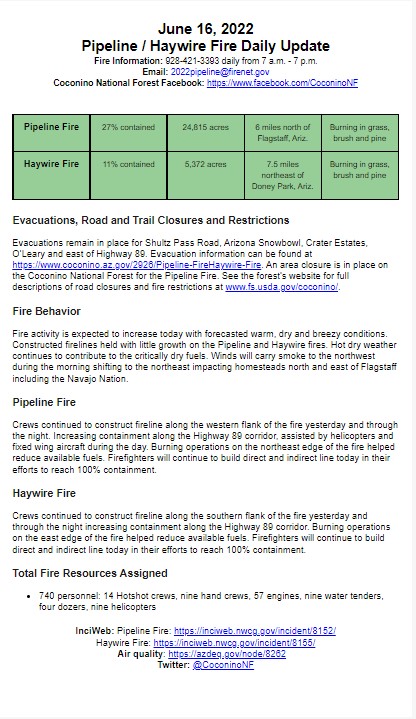
June 16, 2022
Pipeline / Haywire Fire Daily Update
Fire Information: 928-421-3393 daily from 7 a.m. - 7 p.m.
Email: 2022pipeline@firenet.gov
Coconino National Forest Facebook: https://www.facebook.com/CoconinoNF
Pipeline Fire
27% contained
24,815 acres
6 miles north of Flagstaff, Ariz.
Burning in grass, brush and pine
Haywire Fire
11% contained
5,372 acres
7.5 miles northeast of Doney Park, Ariz.
Burning in grass, brush and pine
Evacuations, Road and Trail Closures and Restrictions
Evacuations remain in place for Shultz Pass Road, Arizona Snowbowl, Crater Estates, O’Leary and east of Highway 89. Evacuation information can be found at https://www.coconino.az.gov/2926/Pipeline-FireHaywire-Fire. An area closure is in place on the Coconino National Forest for the Pipeline Fire. See the forest’s website for full descriptions of road closures and fire restrictions at www.fs.usda.gov/coconino/.
Fire Behavior
Fire activity is expected to increase today with forecasted warm, dry and breezy conditions. Constructed firelines held with little growth on the Pipeline and Haywire fires. Hot dry weather continues to contribute to the critically dry fuels. Winds will carry smoke to the northwest during the morning shifting to the northeast impacting homesteads north and east of Flagstaff including the Navajo Nation.
Pipeline Fire
Crews continued to construct fireline along the western flank of the fire yesterday and through the night. Increasing containment along the Highway 89 corridor, assisted by helicopters and fixed wing aircraft during the day. Burning operations on the northeast edge of the fire helped reduce available fuels. Firefighters will continue to build direct and indirect line today in their efforts to reach 100% containment.
Haywire Fire
Crews continued to construct fireline along the southern flank of the fire yesterday and through the night increasing containment along the Highway 89 corridor. Burning operations on the east edge of the fire helped reduce available fuels. Firefighters will continue to build direct and indirect line today in their efforts to reach 100% containment.
Total Fire Resources Assigned
- 740 personnel: 14 Hotshot crews, nine hand crews, 57 engines, nine water tenders, four dozers, nine helicopters
InciWeb: Pipeline Fire: https://inciweb.nwcg.gov/incident/8152/
Haywire Fire: https://inciweb.nwcg.gov/incident/8155/
Air quality: https://azdeq.gov/node/8262
Twitter: @CoconinoNF
Portions of US 89 are now open north of Flagstaff
Related Incident: Haywire Fire
Publication Type: Announcement
Portions of US 89 are now open north of Flagstaff. The highway is now open in both directions from mileposts 426 to 433. Learn more at https://www.facebook.com/AZDOT
Coconino Countys IT Department A 3D Web Viewer
Related Incident: Haywire Fire
Publication Type: Announcement
This viewer provides publicly available data about this incident in a 3D experience. It is a 3D web application for the Pipeline and Haywire fires. The website is interactive and represents Coconino County's commitment to transparency. We are pleased to share the County's publicly available GIS data with citizens, developers, communities and agencies with an interest in spatial data. Use this site to discover, explore and download GIS data.
Haywire Fire Morning Update June 15 2022
Related Incident: Haywire Fire
Publication Type: News
Pipeline Fire at 22,888 acres, 31% containment | Haywire Fire at 5,065 acres, 0% containment
Fires to transition to Type 1 team tomorrow
FLAGSTAFF, Ariz., June 15, 2022 – The Type 1 Great Basin Incident Management Team (IMT) 2 has arrived at the Pipeline and Haywire fires, and is shadowing the Type 2 California Interagency IMT 15. The Type 1 team will assume command of the incident 6 a.m. Thursday.
The Pipeline Fire is currently 22,888 acres with 31% containment and the Haywire Fire is estimated at 5,065 acres with no containment.
While critical fire weather continues due to dry conditions and high temperatures, lower wind speeds allowed aerial operations to resume and continue throughout the day.
In addition to using water and retardant dropping aircraft, crews will continue to look for opportunities to directly engage the fire with the intent to suppress the fire’s edge and to keep the fire from entering communities as it continues to move in a northeast direction. Crews continue to use the 2010 Schultz Fire and recent Tunnel Fire footprints to their advantage.
Current resources on the Pipeline Fire include 561 personnel composed of 12 Hotshot crews and 7 hand crews, 54 engines, 9 water tenders and two dozers.
Current resources on the Haywire Fire include 57 personnel composed of one hand crew, 6 engines, two water tenders and two dozers.
There are roughly 670 personnel working both fires and in a support role at the Incident Command Post. Aerial resources include 8 helicopters and one fixed-wing aircraft working on both fires.
The Coconino National Forest remains in Stage 2 fire and smoking restrictions. Information regarding fire restrictions can be found online at coconinonationalforest.us
PIPELINE FIRE
- Incident information site: https://inciweb.nwcg.gov/incident/8152/
- Size: 22,888 acres.
- Containment: 31%
- Location: 6 miles north of Flagstaff (35.281667, -111.681389)
- Date reported: June 12, 2022 at 10:15 a.m.
- Cause: Unknown and under investigation
- Current resources: 54 engines, 12 Hotshot crews, seven hand crews, nine water tenders, nine dozers, and various aerial resources and miscellaneous overhead.
- Closures: The Coconino NF has closed nearly the entire northern portion of the forest from Interstate 40 toward the north. View the Closure Order and map here. Additionally, Arizona Department of Transportation has closed a portion of Highway 89, which restricts vehicles from traveling north and south in the area of the fire. Check www.az511.com for status updates.
- Smoke impacts: Smoke will impact areas of Doney Park and homesteads northeast of Doney Park, including Navajo Nation.
- Evacuations: Coconino County Sheriff's Office is the authorizing and approving agency for evacuation notices, which works with Coconino County Emergency Management to post information about evacuations and which areas are in Ready, Set, or Go status. To view these areas, visit the County's Emergency Management page.
- Injuries: None.
HAYWIRE FIRE
The Haywire and Double fires have merged and are now being managed solely as the Haywire Fire.
- Incident information site: https://inciweb.nwcg.gov/incident/8155/
- Size: 5,065 acres.
- Containment: 0%
- Location: 7.5 miles northeast of Doney Park (35.371667, -111.433372)
- Date reported: June 13, 2022 at 4:13 a.m.
- Cause: Unknown and under investigation but suspected as originating from a lightning strike from a storm days prior.
- Current resources: 6 engines, one hand crew, two water tenders, two dozers, and various aerial resources and miscellaneous overhead.
- Closures: The Coconino NF has closed nearly the entire northern portion of the forest from Interstate 40 toward the north. View the Closure Order and map here
- Smoke impacts: Smoke will impact homesteads northeast of the fire, including Navajo Nation.
- Evacuations: Coconino County Sheriff's Office is the authorizing and approving agency for evacuation notices, which works with Coconino County Emergency Management to post information about evacuations and which areas are in Ready, Set, or Go status. To view these areas, visit the County's Emergency Management page.
- Injuries: None.
Pipeline and Haywire fires being managed by Type 2 IMT
Related Incident: Haywire Fire
Publication Type: News
Pipeline and Haywire fires being managed by Type 2 IMT
Haywire, Double fires combine into one
FLAGSTAFF, Ariz., June 14, 2022 – The Type 2 California Incident Management Team 15 has assumed management of the Pipeline and Haywire fires north of Flagstaff.
The Pipeline Fire is currently 20,178 acres and the Haywire Fire is estimated at 4,052 acres. The Double Fire, which was first reported Monday, has merged with the Haywire Fire, and is now being managed solely as the Haywire Fire.
The Type 2 team will manage both fires until a Type 1 team assumes control Wednesday.
While critical fire weather remains in effect due to dry conditions and high temperatures, lower wind speeds may allow for aerial operations throughout the day Tuesday and beyond.
In addition to using water and retardant dropping aircraft, crews will spend Tuesday looking for opportunities to directly engage the fire with the intent to suppress the fire's edge and to keep the fire from entering communities as it continues moving in a northeast direction. Crews plan to utilize the 2010 Schultz Fire and recent Tunnel Fire footprints to their advantage.
Current resources on the Pipeline include 360 personnel composed of eight hand crews, 40 engines, six water tenders, five dozers and miscellaneous overhead. Current resources on the Haywire include six engines. There are roughly 500 personnel working on both fires. Aerial resources include six helicopters and one fixed-wing aircraft and are working on both fires.
The Coconino NF remains in Stage 2 fire and smoking restrictions. Information regarding fire restrictions can be found online at coconinonationalforest.us
PIPELINE FIRE
- Incident information site: https://inciweb.nwcg.gov/incident/8152/
- Size: 20,178
- Containment: 0%
- Location: 6 miles north of Flagstaff (35.281667, -111.681389)
- Date reported: June 12, 2022 at 10:15 a.m.
- Cause: Unknown and under investigation
- Current resources: eight hand crews, 40 engines, six water tenders, five dozers and miscellaneous overhead, comprised of 360 personnel.
- Closures: The Coconino National Forest has closed nearly the entire northern portion of the forest from Interstate 40 toward the north. View the Closure Order and map here.
- Smoke impacts: Smoke will impact areas of Doney Park and homesteads northeast of Doney Park, including Navajo Nation.
- Evacuations: Coconino County Sheriff's Office is the authorizing and approving agency for evacuation notices, which works with Coconino County Emergency Management to post information about evacuations and which areas are in Ready, Set, or Go status. To view these areas, visit the County's Emergency Management page. Coconino County has also established a Pipeline Fire Call Center to help evacuees with questions at 928-679-8525.
- Injuries: None.
HAYWIRE FIRE
The Haywire and Double fires have merged and are now being managed solely as the Haywire Fire.
- Incident information site: https://inciweb.nwcg.gov/incident/8155/
- Size: 4,052
- Containment: 0%
- Location: 7.5 miles northeast of Doney Park (35.371667, -111.433372)
- Date reported: June 13, 2022 at 4:13 a.m.
- Cause: Unknown and under investigation but suspected as originating from a lightning strike from a storm days prior.
- Current resources: six engines, hand crews, dozers and aerial resources. Roughly 240 personnel.
- Closures: The Coconino National Forest has closed nearly the entire northern portion of the forest from Interstate 40 toward the north. View the Closure Order and map here. Additionally, Arizona Department of Transportation has closed a portion of Highway 89, which restricts vehicles from traveling north and south in the area of the fire. Check www.az511.com for status updates.
- Smoke impacts: Smoke will impact homesteads northeast of the fire, including Navajo Nation.
- Evacuations: Coconino County Sheriff's Office is the authorizing and approving agency for evacuation notices, which works with Coconino County Emergency Management to post information about evacuations and which areas are in Ready, Set, or Go status. To view these areas, visit the County's Emergency Management page. Coconino County has also established a Pipeline Fire Call Center to help evacuees with questions at 928-679-8525.
- Injuries: None.
Pipeline Fire continues burning north of Flagstaff
Related Incident: Haywire Fire
Publication Type: News
FLAGSTAFF, Ariz., June 13, 2022 – Strong winds continue to move the Pipeline Fire toward the northeast, as two additional wildfires the Haywire Fire and Double Fire are reported about 6 miles further ahead.
The exact size the the Pipeline Fire is unknown due to the inability for an overnight infrared flight. However, fire managers estimate the fire to be about 5,000 acres currently. Firefighters are working to suppress and keep fire from entering areas near communities, while deflecting the fire along the San Francisco Peaks toward the northeast as it enters some of the 2010 Schultz Fire and recent Tunnel Fire burn scars.
Strong winds coupled with warm weather have been the challeging factor for firefighters and air resources, as winds are predicted to be 40-50 mph today. The Coconino NF remains in Stage 2 fire and smoking restrictions. Information regarding fire restrictions can be found online at coconinonationalforest.us
PIPELINE FIRE
- Incident information site: https://inciweb.nwcg.gov/incident/8152/
- Size: Estimated at 5,000 acres
- Containment: 0%
- Location: 6 miles north of Flagstaff (35.281667, -111.681389)
- Date reported: June 12, 2022 at 10:15 a.m.
- Cause: Unknown and under investigation
- Current resources: 11 engines, three water tenders, three Hotshot crews, one hand crew, four dozers, various aerial resources and miscellaneous overhead.
- Closures: The Coconino National Forest has closed nearly the entire northern portion of the forest from Interstate 40 toward the north. View the Closure Order and map here.
- Smoke impacts: Smoke will impact areas of Doney Park and homesteads northeast of Doney Park, including Navajo Nation.
- Evacuations: Coconino County Sheriff's Office is the authorizing and approving agency for evacuation notices, which works with Coconino County Emergency Management to post information about evacuations and which areas are in Ready, Set, or Go status. To view these areas, visit the County's Emergency Management page.
- Injuries: None.
HAYWIRE FIRE
- Incident information site: https://inciweb.nwcg.gov/incident/8155/
- Size: Estimated at 1,600 acres; Will likely combine with Double Fire.
- Containment: 0%
- Location: 7.5 miles northeast of Doney Park (35.371667, -111.433372)
- Date reported: June 12, 2022 at 4:13 p.m.
- Cause: Unknown and under investigation but suspected as originating from a lightning strike from a storm days prior.
- Current resources: 10 engines. Multiple dozers have been ordered.
- Closures: The Coconino National Forest has closed nearly the entire northern portion of the forest from Interstate 40 toward the north. View the Closure Order and map here. Additionally, Arizona Department of Transportation has closed a portion of Highway 89, which restricts vehicles from traveling north and south in the area of the fire. Check www.az511.comfor status updates.
- Smoke impacts: Smoke will impact homesteads northeast of the fire, including Navajo Nation.
- Evacuations: Coconino County Sheriff's Office is the authorizing and approving agency for evacuation notices, which works with Coconino County Emergency Management to post information about evacuations and which areas are in Ready, Set, or Go status. To view these areas, visit the County's Emergency Management page.
- Injuries: None.
DOUBLE FIRE
- Incident information site: https://inciweb.nwcg.gov/incident/8155/
- Size: Estimated at 500 acres
- Containment: 0%
- Location: 2 miles south/southwest of the origin of the Haywire Fire (35.345842, -111.451177)
- Date reported: June 12, 2022 at 4:13 p.m.
- Cause: Unknown and under investigation but suspected as originating from a lightning strike from a storm days prior.
- Current resources: Part of the Haywire Fire resources responding.
- Closures: The Coconino National Forest has closed nearly the entire northern portion of the forest from Interstate 40 toward the north. View the Closure Order and map here. Additionally, Arizona Department of Transportation has closed a portion of Highway 89, which restricts vehicles from traveling north and south in the area of the fire. Check www.az511.com for status updates.
- Smoke impacts: Smoke will impact homesteads northeast of the fire, including Navajo Nation.
- Evacuations: Coconino County Sheriff's Office is the authorizing and approving agency for evacuation notices, which works with Coconino County Emergency Management to post information about evacuations and which areas are in Ready, Set, or Go status. To view these areas, visit the County's Emergency Management page.
- Injuries: None.
June 24 Fire Update
Related Incident: Contreras Fire
Publication Type: News
INCIDENT INFORMATION: https://inciweb.nwcg.gov/incident/8154
Twitter: @BLMAZFire Facebook: @TON.Emergency.Management or @blmarizona
E-mail: 2022.contreras@firenet.gov
SUMMARY: The Contreras Fire started June 11 on a remote ridge of the Baboquivari Mountain range, north of the Baboquivari Peak, 20 miles east of Sells, Arizona, on the Tohono O'odham Indian Reservation.
TODAY:
This is the final daily update for the Contreras Fire. The Fire received up to two inches of rain yesterday, helping crews bring containment of the fire to 100%. Accelerated demobilization of resources is in progress.
A local Bureau of Indian Affairs Type 4 Incident Management Team will assume command on Saturday, June 25, with resources sufficient to perform any mop up and suppression repair activities. A National Burned Area Emergency Response Team is in the area conducting assessments. They will provide recommendations for both short- and long-term repair and/or recovery efforts if any are necessary.
Kitt Peak National Observatory continues to be in evacuation status, but electrical crews and maintenance workers have been allowed into the area to address infrastructure needs.
The Monsoon is firmly in place across the Desert Southwest. Another round of scattered showers and thunderstorms is expected Friday afternoon and through the weekend, bringing a continued threat for flash flooding.
Flash flooding from intense rainfall has potential to impact roads and loosen rocks on steep slopes in burned areas. Debris flow from these areas can cause dangerous conditions. Residents and drivers are encouraged to remain vigilant and watch for rapidly changing conditions. Wind gusts up to 45 mph and blowing dust could also create hazardous conditions.
The Eastern Area Incident Management Team, under the leadership of Incident Commander Brian Pisarek, wishes to express its gratitude to all cooperators, stakeholders, partners, local units, businesses and the communities of Three Points and Robles Junction for their collaboration and partnerships. A special thanks is extended to all initial attack crews, and to the Southeast Zone Type 3 Incident Management Team, who initially took command of the fire on June 14, and helped prepare the way for future full containment of the Contreras Fire.
Beginning Saturday, June 25, requests for information on the Contreras Fire may be directed to Bureau of Indian Affairs Public Affairs Officer Robyn Broyles at Robyn.Broyles@BIA.gov or 208-559-1187.
INCIDENT STATISTICS
- Fire start date: June 11, 2022
- Cause: Lightning
- Size: 29,482 acres
- Containment: 100%
- Total Personnel: 254
- Jurisdiction: BIA, Papago Agency
RESOURCES
Crews: 1
June 23 Fire Update
Related Incident: Contreras Fire
Publication Type: News
INCIDENT INFORMATION: https://inciweb.nwcg.gov/incident/8154
Fire Information: 520-302-5120
Twitter: @BLMAZFire Facebook: @TON.Emergency.Management or @blmarizona
E-mail: 2022.contreras@firenet.gov
SUMMARY: The Contreras Fire started June 11 on a remote ridge of the Baboquivari Mountain range, north of the Baboquivari Peak, 20 miles east of Sells, Arizona, on the Tohono O'odham Indian Reservation.
TODAY: The final daily update for the Contreras Fire will be distributed Friday, June 24. Containment on the Contreras Fire increased to 83% yesterday. Minimal fire activity is expected going forward. Resources are slowly being released to other incidents or to their home units.
Residents of Pan Tak returned home Wednesday evening. Fire behavior and smoke production will diminish significantly over the next 36 hours as higher humidity settles in and wetting thunderstorms pass through. Smoke may still be intermittently visible from well within the containment area.
Remaining resources on the Contreras Fire will focus on connecting containment lines on the northwest section of the fire. At Kitt Peak Observatory, staff will return to the site today to further perform assessments on scientific structures and equipment. Scouting for damage from suppression activities remains a priority in all areas of the fire’s footprint.
Suppression repair will follow strict standards agreed upon by agency administrators working collaboratively to manage the fire. Some of these activities, depending on jurisdictional policies and land use agreements, could include constructing water bars across roads to divert water runoff; chipping and/or debris removal; repairing fence line; removal of trash and supplies; removal of hazard trees or other vegetation and signage; and removal of structure suppression-related equipment such as hoses and sprinkler systems.
The Burned Area Emergency Response Team will begin suppression repair assessments today. This team is responsible for determining any issues and concerns within the burned area. The team will provide recommendations for both short- and long-term repair and/or recovery efforts.
YESTERDAY:
At Kitt Peak Observatory, crews scouted for and extinguished any hot spots. Water tenders refilled a pond that was used in the early stages of firefighting activities.
Crews made extensive progress on total fire containment, connecting control lines on all but one small section in the northwest corner of the fire. Scouting for hot spots and conducting assessments of areas or resources requiring repair was a primary activity both at Kitt Peak and in the southern portion of the fire.
INCIDENT STATISTICS
- Fire start date: June 11, 2022
- Cause: Lightning
- Size: 29,482 acres, an increase of 505 acres from yesterday
- Containment: 83%
- Total Personnel: 383
- Jurisdiction: BIA, Papago Agency
RESOURCES
Evacuations: Evacuations have been lifted for Kitt Peak Observatory; however, the Observatory remains closed. Evacuation orders for Pan Tak and the Elkhorn Ranch area have been lifted.
Road Closures: Kitt Peak Road (State Route 386) remains closed to the public.
Other Considerations: Debris flows in or near wildfire burn scars during heavy rain events can cause dangerous conditions. Residents and drivers are encouraged to remain vigilant and watch for rapidly changing conditions. Wind gusts up to 45 mph and blowing dust could also create hazardous conditions.
Contreras Fire Operations Video Update June 23 2022
Related Incident: Contreras Fire
Publication Type: Announcement
June 22 Fire Update
Related Incident: Contreras Fire
Publication Type: News
INCIDENT INFORMATION: https://inciweb.nwcg.gov/incident/8154
Fire Information: 520-302-5120 Media Information: 520-497-3625
Twitter: @BLMAZFire Facebook: @TON.Emergency.Management or @blmarizona
E-mail: 2022.contreras@firenet.gov
SUMMARY: The Contreras Fire started June 11 on a remote ridge of the Baboquivari Mountain range, north of the Baboquivari Peak, 20 miles east of Sells, Arizona, on the Tohono O'odham Indian Reservation.
TODAY: Today, crews will follow similar burning operations from yesterday that are necessary to strengthen containment lines. These operations entail burning interior pockets of vegetation. As this work occurs, the fire’s acreage will increase; however, the fire’s footprint will change very little.
Aircraft will be available to support ground crews working to reduce fire behavior on slopes below Kitt Peak. This work is key in protecting utility corridors that provide power to Kitt Peak.
On top of Kitt Peak within the Observatory property, structure protection crews will continue looking for and extinguishing heat. Water tenders will also replenish a pond that served as a critical water source for firefighting operations early in the fire.
Assessments of Observatory structures are ongoing. The south half of the fire will remain in patrol status, with fire personnel actively scouting for damage caused by fire suppression activities.
A Burned Area Emergency Response Team is expected to begin suppression repair assessments Thursday. This team is responsible for determining any issues and concerns within the burned area. The team will provide recommendations for both short- and long-term repair and/or recovery efforts.
Fire behavior analysts anticipate significant reduction in fire behavior over the next 24 hours, with more humid conditions and a possibility of wetting thunderstorms. Threats to Kitt Peak Observatory, Pan Tak and Hayhook Estates are expected to be significantly reduced over the next 36 hours as interior vegetation to the north and east burn out. Flash flooding is a concern with periods of intense rainfall.
YESTERDAY: Very little perimeter growth was detected. West of Pan Tak and the Coyote Mountain Wilderness Area, crews conducted successful burning operations within the interior of the fire to strengthen containment lines and prevent future growth.
Along the south perimeter of the fire, especially in and around Elkhorn Ranch, crews scouted for damage from suppression activities.INCIDENT STATISTICS
- Fire start date: June 11, 2022
- Cause: Lightning
- Size: 28,977 acres, an increase of 4,216 acres from yesterday
- Containment: 50%
- Total Personnel: 440
- Jurisdiction: BIA, Papago Agency
RESOURCES
Crews: 9
Engines: 28
Water Tenders: 19
Graders: 2
Helicopters: 7
Evacuations: The Kitt Peak Observatory is in GO status. Pan Tak is in GO status. Hayhook Estates is now in READY status. Elkhorn Ranch is now in READY status.
Road Closures: Kitt Peak Road (State Route 386) remains closed.