
June 18 Fire Update
Related Incident: Contreras Fire
Publication Type: News
INCIDENT INFORMATION: https://inciweb.nwcg.gov/incident/8154
Fire Information: 520-302-5120 Media Information: 520-497-3625
Twitter: @BLMAZFire Facebook: @TON.Emergency.Management or @blmarizona
E-mail: 2022.contreras@firenet.gov
SUMMARY: The Contreras Fire started June 11 on a remote ridge of the Baboquivari Mountain range, north of the Baboquivari Peak, 20 miles east of Sells, Arizona, on the Tohono O'odham Indian Reservation.
TODAY: Aerial resources are expected to remain over the fire all day as long as lightning is not present in the area. Fire behavior remains typical for the Contreras Fire, with an increased movement upslope, pushed by winds and extremely dry fuels made up of brush and short grass. On the north end of the fire along Highway 86, and toward the Pan Tak and Cowtown communities, fire behavior will be monitored closely with the addition of extra crews and engines. Toward these areas, there will be opportunity for direct attack by crews and air support due to moderate terrain and sparse vegetation. Structure protection crews remain in the Kitt Peak Observatory and Pan Tak areas. Assessments of the Kitt Peak Observatory will commence today if conditions allow for safe entry into the area. Initial assessment indicates that all the domes and other scientific facilities have been protected from the worst part of the fire to date. Four non-scientific buildings on the west side of the Observatory property were lost in the fire. Structure protection crews have successfully placed defensible lines around all remaining structures. On the south end of the fire near Elkhorn Ranch, an engine and hand crew will check for hot spots along containment lines. The fire to the west will be allowed to burn down the slope into more advantageous terrain that will allow crews to engage the fire safely. Engines and crews from jurisdictional agencies will continue to patrol the western flank.
YESTERDAY: Northern firefighting operations focused heavily on structure protection of the Kitt Peak Observatory and the Pan Tak Community in the Schuk Toak District of the Tohono O’odham Nation. An evacuation order was implemented for the community due to its proximity to the fire and the fire’s unpredictably. A shelter has been established for community members. Six helicopters helped crews on the ground engaged the fire, which was burning through highly flammable vegetation. Defensible firing actions were conducted to moderate the intensity of approaching fire. On the east side of the fire, crews dedicated their efforts to scouting for access points for crews and equipment. The fire moved very slowly downslope and naturally extinguished in some areas. On the south end of the fire near Elkhorn Ranch, structure protection crews worked to establish stronger control lines, removed flammable fuels with saws and hand tools, and prepared hose lay and sprinkler systems to ensure the safety of the ranch. Some resources were moved to the north portion of the fire where more fire activity was prevalent. The western perimeter of the fire was allowed to move slowly and southwesterly toward more favorable terrain where crews could engage the fire.
INCIDENT STATISTICS
- Fire start date: June 11, 2022
- Cause: Lightning
- Acres: 17,646
- Containment: 0%
- Total Personnel: 300+
- Jurisdiction: BIA, Papago Agency
RESOURCES
Crews: 8
Engines: 12
Water Tenders: 5
Helicopters: 6
Evacuations: Elkhorn Ranch, on the south end of the fire, is in SET status. The Kitt Peak Observatory, north of the fire, is in GO status. The community of Pan Tak has been precautionarily evacuated and a shelter has been established for those residents.
Road Closures: Kitt Peak Road (State Route 386)
June 17 Fire Update
Related Incident: Contreras Fire
Publication Type: News
INCIDENT INFORMATION: https://inciweb.nwcg.gov/incident/8154
Fire Information: 520-302-5120 Media Information: 520-497-3625
Twitter: @BLMAZFire Facebook: @TON.Emergency.Management or @blmarizona
E-mail: 2022.contreras@firenet.gov
SUMMARY: The Contreras Fire started June 11 on a remote ridge of the Baboquivari Mountain range, north of the Baboquivari Peak, 20 miles east of Sells, Arizona, on the Tohono O'odham Indian Reservation. The fire, burning in highly flammable grass and brush in steep and rugged terrain, is difficult for firefighters to access.
TODAY: Fire activity picked up overnight, and breached Kitt Peak Road (Road 386). Fire resources engaged the fire around 2:00 a.m. The fire reached the Observatory site and crossed over a decision point to place the community of Pan Tak into GO status. Eastern Area Team Incident Commander Brian Pisarek wishes to recognize the community for its forethought and successful planning efforts that have ensured the safety of the residents in and around the Pan Tak area.
Air support will be critical for assisting ground crews today. Five helicopters have been assigned to support suppression efforts today. Dense shrub ground cover below Kitt Peak is allowing the fire to make rapid upslope growth. Structure protection crews are actively scouting and engaging the fire at the Kitt Peak Observatory, and active scouting operations are in place between the Observatory and in the community of Pan Tak. Electrical supply to the Observatory has been suspended by the utility provider to mitigate unintentional sparking, and ground crews are utilizing fuel reduction methods to clear flammable ground material and create fuel breaks. More crews have been ordered and are expected to arrive today.
On the east side of the fire, scouts are actively monitoring fire behavior and looking for access points for crews. On the south end of the fire near Elkhorn Ranch, structure protection crews are utilizing fire control lines, sprinkler systems and other suppression methods to ensure the safety of the ranch community, visitors and its inholdings. A small 40-acre spot fire, which was contained yesterday, will be actively monitored and mop-up operations will commence if necessary. To the west, the fire is being actively monitored and allowed to move toward more favorable terrain where the fire may be engaged more effectively and safely. Temperatures are expected to be more favorable today, and a chance of precipitation this afternoon and into the weekend is expected to slow the growth of the fire. Critical fire weather remains in the area, and there is a potential for frequent lightning and gusty, erratic winds.
YESTERDAY: Fire growth on the north entered the flats, and crews assessed fire activity with ground patrol and aircraft. Priority suppression and structure protection activity occurred near Kitt Peak Observatory, including fire line construction, direct suppression methods and fuel reduction. Air tanker operations were heavily utilized. On the south, the fire was successfully prevented from threatening structures at Elkhorn Ranch, where hose lay, sprinkler operations and fuel reduction tactics were employed. A 40-acre spot fire was successfully contained and mopped up on the southeast corner of the fire.
INCIDENT STATISTICS
- Fire start date: June 11, 2022
- Cause: Lightning
- Acres: 11,489
- Containment: 0%
- Total Personnel: 300+
- Jurisdiction: BIA, Papago Agency
RESOURCES
June 16 Fire Update
Related Incident: Contreras Fire
Publication Type: News
INCIDENT STATISTICS
- Fire start date: June 11, 2022
- Cause: Lightning
- Acres: 11,489
- Containment: 0%
- Total Personnel: 300+
- Jurisdiction: BIA, Papago Agency
SUMMARY: The Contreras Fire started June 11 on a remote ridge of the Baboquivari Mountain range, north of the Baboquivari Peak, 20 miles east of Sells, Arizona on the Tohono O'odham Indian Reservation. It is approximately 11,500 acres at the time of this update, burning grass and brush in steep and rugged terrain that is difficult for firefighters to access.
The Type 2 Eastern Area Incident Management Team has assumed command of the Contreras Fire as of June 16, under the direction of Incident Commander Brian Pisarek.
To date, aviation resources and retardant efforts have had limited success due to heavy smoke, high winds and extremely dry fuels. Smoke from the fire is visible from Sells and Three Points, and residual effects have been reported near Tucson. Firefighter and public safety remain top priority, as well as providing protection and minimizing impacts to cultural, heritage, natural resources and wildlife.
TODAY: The hottest temperatures of the year are expected today, which will slow tactical efforts on the ground, considering emergency responder safety. Breezy west winds with gusts up to 25 mph are forecasted for this afternoon. Firefighters will scout and identify potential holding features such as roads, trail systems and natural barriers such as rock outcroppings and vegetation breaks. The fire is currently being managed in two divisions, north and south. In addition to ground crews which include engines and water tenders, structure protection divisions have been assigned to the Kitt Peak Observatory to the north and Elkhorn Ranch to the south.
Critical fire weather remains in the region. Moisture will begin to move through the region on Friday, carrying a chance of thunderstorms with limited moisture expected, frequent lightning and gusty, erratic winds.
An evening operational update on the Contreras Fire will be provided via Facebook only.
YESTERDAY: High winds, low relative humidity and extremely rough terrain challenged firefighting efforts. The fire almost doubled in size, gaining the most growth on the north end toward Kitt Peak Observatory.
Firefighters attempted direct line construction to protect the Elkhorn Ranch to the south, with several contingency lines accessible for firefighter safety. The fire is approximately .25 miles from the ranch, and 1.5 miles from the Kitt Peak Observatory to the north.
There is a road closure on state route 386 additionally Kit Peak is in GO
Related Incident: Contreras Fire
Publication Type: Announcement
There is a road closure on state route 386, additionally, Kit Peak is in GO evacuation status .
There is a road closure on state route 386 additionally Kit Peak is in GO
Related Incident: Contreras Fire
Publication Type: Closures
There is a road closure on state route 386, additionally, Kit Peak is in GO evacuation status .
June 15 Update
Related Incident: Contreras Fire
Publication Type: News
Contreras Fire Quick Facts:
- Size: 6.662 acres (acreage updated at 5pm)
- Containment: 0%
- Road Closures and Evacuations: None
- Resources on the Fire: 3 helicopters, 1 air attack, 4 hand crews, 4 Water Tenders, 4 engines
- Total Personnel: 300+
- Jurisdiction: BIA, Papago Agency
- Reservation: Tohono O'odham Nation, AZ
- Start Date: June 11, 2022
- Fire Cause: Under Investigation
- InciWeb: https://inciweb.nwcg.gov/incident/8154/
Sells, AZ – A continued evaluation of fire activity and increased incident complexity guided agency administrators to order a Type 2 Incident Management Team. The Southeast Arizona Type 3 Incident Management Team will in brief the Eastern Area Type 2 Incident Management Team at 1800 today. The Type 2 Incident Management Team will take command over the Contreras Fire at 0600 tomorrow morning. The fire grew to 5,754 acres, with no containment at this time. High winds, low relative humidity and extremely rough terrain continue to challenge firefighting efforts. The fire remained active throughout the night and into the morning, moving through the drought stressed vegetation.
The fire grew to the north. Aviation resources have had limited success due to smoke in the area and retardant has had limited success due to extremely dry fuels and high winds. Smoke from the fire is visible from Sells and Three Points, however, it does not pose a threat to communities.
Firefighters are attempting direct line construction to protect the Elk Horn Ranch with several contingency lines available for firefighter safety. The fire is approximately ¼ mile from the ranch.
Evacuations: None. Elk Horn Ranch, on the south end of the fire, is in SET status and the Kit Peak Observatory, north of the fire, is also in SET status. The fire is approximately four miles from the observatory.
Management Objective: Reduce fire intensity using aircraft and protect the Elk Horn Ranch and Kit Peak Observatory. Future objectives will include transferring command of the fire from the Southeast Arizona Type 3 Incident Management Team to the Eastern Area Type 2 Incident Management Team and continued work to keep the fire as small as safety possible while protecting firefighter and public safety.
Operational Update: Firefighters continue to assess the fire situation and work toward establishing point protection for the Elk Horn Ranch and Pit Peak Observatory. Air support is being utilized to keep the fire size as small as possible as it burns down steep and inaccessible slopes.
Background: The Contreras Fire started June 11 on a remote ridge of the Baboquivari Mountain range, north of the Baboquivari Peak, 20 miles east of Sells, Arizona on the Tohono O'odham Indian Reservation.
Primary and Cooperating Agencies: Bureau of Indian Affairs, Tohono O’odham Nation, Bureau of Land Management.
A fire update will be released when significant activity occurs. Visit InciWeb for the most current fire information.
June 14 Update
Related Incident: Contreras Fire
Publication Type: News
Contreras Fire
Quick Facts
Sells, AZ – The Southeast Arizona Type Three Incident Management Team assumed command over the Contreras Fire this morning at 0600. The fire was mapped by Infrared Flight overnight at 1,670 acres, with no containment at this time. Hot and dry winds from the south/southwest are pushing the fire to the north/northeast predominantly. The fire remained active throughout the night and into the morning, moving through the drought stressed vegetation.
Smoke from the fire is visible from Sells and Three Points, however, it does not pose a threat to communities.
Firefighters remain focused on structure protection at the Elk Horn Ranch, which is approximately a half mile south of the fire and assessing areas to the north and east of the current fire area.
Evacuations: None
Management Objective: Reduce fire intensity using aircraft, giving firefighters time to assess the fire landscape. Future objectives will include working with the Bureau of Land Management Gila District and the Arizona Department of Forestry and Fire Management to develop a successful management strategy that will keep the fire as small as safety possible while protecting firefighter and public safety.
Operational Update: Firefighters continue to assess the fire situation. Air support being utilized to keep the fire size as small as possible as it burns down steep and inaccessible slopes.
Background: The Contreras Fire started June 11 on a remote ridge of the Baboquivari Mountain range, north of the Baboquivari Peak, 20 miles east of Sells, Arizona on the Tohono O'odham Indian Reservation.
Primary and Cooperating Agencies: Bureau of Indian Affairs, Tohono O’odham Nation, Bureau of Land Management.
A fire update will be released when significant activity occurs. Visit InciWeb for the most current fire information.
June 13 Update
Related Incident: Contreras Fire
Publication Type: News
| Contreras Fire Quick Facts | | | 573 acres | | 0% | | | | 2 helicopters, 4 hand crews, 4 Water Tenders, 4 engines | | 120 | |
BIA, Papago Agency
| | Tohono O'odham Nation, AZ | | June 11, 2022 | | Under Investigation | |
June 12 Update
Related Incident: Contreras Fire
Publication Type: News
Sells, AZ – The Contreras Fire started June 11 on a remote ridge of the Baboquivari Mountain range, north of the Baboquivari Peak, 20 miles east of Sells, Arizona on the Tohono O'odham Indian Reservation. It is approximately 80 acres, burning grass and brush in steep and rugged terrain that is difficult for firefighters to access.
Airtankers have slowed the fire’s growth using retardant. Two hand crews and a local fire engine are assigned. These resources will assess safe areas to begin to contain the remote fire.
BIA, Papago Agency plans to transfer command of the fire to the Southeast Zone Incident Management Team 3 the evening of June 13.
Evacuations: None
Management Objective: Reduce fire size using aircraft, giving firefighters time to assess the fire landscape. Future objectives will include working with the Bureau of Land Management Gila District and the Arizona Department of Forestry and Fire Management to develop a successful management strategy that will keep the fire as small as safety possible while protecting firefighter and public safety.
Operational Update: Firefighters are assessing the fire situation. Heavy airtankers are providing air support to keep the fire size as small as possible as it burns down steep and inaccessible slopes.
Smoke from the fire is visible from Sells, AZ; however, it does not currently pose a threat to communities.
Primary and Cooperating Agencies: Bureau of Indian Affairs, Tohono O’odham Nation, Bureau of Land Management, Arizona Department of Forestry and Fire Management.
A fire update will be released when significant activity occurs. Visit InciWeb for the most current fire information.
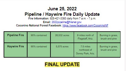
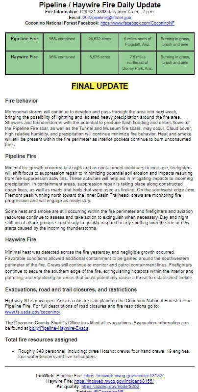
FINAL UPDATE Pipeline Fire June 25
Related Incident: Pipeline Fire
Publication Type: News
FINAL UPDATE
Fire behavior
Monsoonal storms will continue to develop and pass through the area into next week, bringing the possibility of lightning and isolated heavy precipitation around the fire area. Showers and thunderstorms with the potential to produce flash flooding and debris flows off the Pipeline Fire scar, as well as the Tunnel and Museum fire scars, may occur. Cloud cover, high relative humidity, and precipitation will continue minimize fire behavior. Heat and smoke will still be present within the fire perimeter as interior pockets continue to burn unconsumed fuels.
Pipeline Fire
Minimal fire growth occurred last night and as containment continues to increase, firefighters will shift focus to suppression repair to minimizing potential soil erosion and impacts resulting from fire suppression activities. These activities will help aid in mitigating impacts to incoming precipitation. In containment areas, suppression repair is taking place along constructed dozer lines, as well as roads and trails that were used as fireline. On the southwest edge from Fremont peak running north toward the Inner Basin Trailhead, crews are monitoring fire progression and will engage as necessary.
Some heat and smoke are still occurring within the fire perimeter and firefighters and aviation resources continue to assess and take action to extinguish when necessary. Day and night shift initial attack groups stand ready to quickly respond to any spotting over the line or new starts caused by the incoming thunderstorms.
Haywire Fire
Minimal heat was detected across the fire yesterday and negligible growth occurred. Favorable conditions allowed additional containment to be gained around the southwestern perimeter of the fire. Crews will continue to monitor and patrol containment lines. Firefighters continue to secure the southern edge of the fire, extinguishing hotspots within the interior and patrolling and monitoring for areas that could potentially cause a threat to established fireline.
Evacuations, road and trail closures, and restrictions
Highway 89 is now open. An area closure is in place on the Coconino National Forest for the Pipeline Fire. For full descriptions of road closures and fire restrictions go to: www.fs.usda.gov/coconino/.
The Coconino County Sheriff's Office has lifted all evacuations. Evacuation information can be found at bit.ly/Pipeline-Haywire-Evacs.
Total fire resources assigned
- Roughly 348 personnel, including: three Hotshot crews, four hand crews, 19 engines, four water tenders and five helicopters
InciWeb: Pipeline Fire: https://inciweb.nwcg.gov/incident/8152/
Haywire Fire: https://inciweb.nwcg.gov/incident/8155/
Air quality: https://azdeq.gov/node/8262
Twitter: @CoconinoNF