
Cedar Creek Fire Closure 6 Huckleberry Flats Willamette NF 992022
Related Incident: Cedar Creek Fire
Publication Type: Closures
Due to potential fire spread, the Willamette National Forest has issued an emergency closure order for the Cedar Creek Fire on on September 9, 2022. The closure area is in Lane County and within the boundaries of the Willamette NF administrative boundaries. The closure applies to the NFS areas, roads, trails and trailheads. Please refer to the attached closure order and map.
Cedar Creek Fire Smoke Outlook Sept 9
Related Incident: Cedar Creek Fire
Publication Type: News
Special Statement
Red Flag Warning today through Saturday for strong east winds and low relative humidity. 3 Day smoke outlook available at: https://outlooks.airfire.org/outlook/7f95b6c6?%20preview=true
Fire
The Cedar Creek Fire in Central Oregon is 33,099 acres with 12% containment. The fire grew 1,613 acres over the past 24 hours. We are expecting very active fire activity today, with hotter temperatures, strong east winds and low relative humidity values.
Smoke
Areas west of the Cedar Creek fire will have the greatest impacts today, including Oakridge and the Eugene/Springfield area. Oakridge will see USG to unhealthy air quality today, with periods of very unhealthy possible. The Eugene/Springfield area will see decreasing air quality through the afternoon hours, as the east winds bring smoke into the area. Health and Safety Message Please remember to check with your doctor if you're feeling effects from the smoke such as chest tightness or difficulty breathing. Do you know how to check your local air quality? Try out the map at fire.airnow.gov for current conditions. For real time information see Fire.airnow.gov, oakridgeair.org, and LRAPA - Today's Current Air Quality.
Cedar Creek Fire Update 992022
Related Incident: Cedar Creek Fire
Publication Type: News
Cedar Creek Fire September 9, 2022 Daily Update – 10:00 AM
Cedar Creek Fire Quick Facts
Size: 33,099 acres
Contained: 12%
Start Date: August 1, 2022
Location: 15 miles E of Oakridge, OR
Cause: Lightning
Total personnel: 862
Resources: 27 engines
15 crews
31 heavy equipment
7 helicopters
2 scoopers
Lane Electric Cooperative will implement a public power safety shutoff starting at 5 p.m. on Friday, September 9 through the evening of Sunday, September 11. This outage will impact nearly all members, with the city centers of Oakridge, Lowell, and Veneta remaining powered to provide key services. Call or visit 541-484-1151 Lane Electric for updates or changes.
Current Situation: East winds, low humidities, and high temperatures will cause the fire to be active today. The highest activity will occur where lichen is present in trees and there is a high concentration of down wood. Where winds align with slopes, tree canopy fire and fire spotting are anticipated. Last night scouting occurred at high points to assess fire growth but smoke limited visibility. The fire spotted over the Winchester Trail to the north. Alaska Team 1 has joined Northwest Team 6 to manage the eastern side of the fire. This has brought key middle management personnel to the fire and allows firefighters to have shorter driving times to the east side of the fire.
Today’s Activities: With critical fire weather expected today, operations leaders will be continuously assessing fire growth and focusing on strategic placement of firefighters in anticipation of changing conditions throughout the day. Firefighters are working on fireline from north Waldo Lake to Charlton Lake connecting to Forest Service Road 4290 to hold the fire from continuing to move south. On Forest Service Road 2421 firefighters will be watching for any spot fires and holding the fire at the road. Crews will be engaging the spot fires north of the Winchester Trail trying to extinguish them if safe to do so. Firefighters are also coordinating with the Middle Fork Ranger District and Lane County Oregon State Fire Marshal representative in order to provide initial attack support to any new fire starts that could occur.
Weather: A RED FLAG Warning is in effect today through at least Saturday due to hot, dry, and windy conditions. East Winds speeds are expected to be 15-25 with gusts of up to 50 mph on ridges. Toward the afternoon the valley will become windy. Poor humidity levels overnight will allow for an extended burn window.
Closures: The Deschutes National Forest and Willamette National Forest have implemented closures for the Cedar Creek Fire. Please visit Willamette National Forest and Deschutes National Forest for detailed closure orders and a joint map. A Temporary Flight Restriction (TFR) is in place. Pacific Crest Trail hikers should visit pcta.org for current information.
Restrictions: Fire restrictions are in place on the Willamette National Forest and Deschutes National Forest.
Smoke: Smoke Forecast Outlooks are available at https://outlooks.wildlandfiresmoke.net/outlook.
Fire Information: 8:00 AM – 8:00 PM | Phone: 541-201-2335 | Email: 2022.cedarcreek@firenet.gov
Online: https://inciweb.nwcg.gov/incident/8307/ | https://www.facebook.com/CedarCreekFire2022/ |
YouTube: https://www.tinyurl.com/cedarcreekfireyoutube
Evacuations: Sign-up for emergency mobile alerts by going to oralert.gov Please check with Lane County Sheriff’s Office 541-682-4150 and Deschutes County Sheriff’s Office 541-693-6911 for updates and changes. Go to https://bit.ly/3D51kvC to view a map.Actualizacin diaria Incendio de Cedar Creek sept 8
Related Incident: Cedar Creek Fire
Publication Type: News
Actualización diaria Incendio de Cedar Creek
8 de Septiembre
Datos rápidos del Incendio Cedar Creek Tamaño: 31,486 acres Contenido: 18% Fecha de inicio: 1 de agosto de 2022 Ubicación: 15 millas al este de Oakridge, OR Causa: Tormenta eléctrica Personal total: 849 Recursos: 19 camiones de bomberos 15 tripulaciones 37 equipos pesados 7 helicópteros
NUEVOS NIVELES DE EVACUACIÓN: Ayer, la oficina del alguacil del condado de Deschutes (Deschutes County Sheriff’s Office) aumentó sus niveles de evacuación para las áreas del lago Cultus Lake y el embalse Crane Prairie Reservoir. Visite los sitios web del condado Deschutes y del condado Lane para obtener información actualizada.
Advertencia de bandera roja: Una advertencia de bandera roja entrará en vigencia a partir de la medianoche del viernes por la mañana, debido a la baja humedad y los fuertes vientos del este. Se espera que la velocidad del viento sea de 15 a 25 mph con ráfagas de hasta 35 mph, el viernes por la mañana y por la tarde. Se espera que los vientos aumenten durante la noche del viernes con velocidades de 15 a 25 mph y ráfagas de hasta 50 mph.
Junta virtual para la comunidad: Hoy, jueves 8 de septiembre, 7:00 PM. El tema de la junta se enfocará en el condado de Deschutes y el centro de Oregon, virtualmente en la página de Facebook de Cedar Creek Fire. Situación actual: Ayer, el fuego continuó avanzando hacia el noreste del lago Waldo. Llegó a los lagos Lower Quinn Lake y Irish Lake en el norte. En el este, tocó la base de Lemish Butte y cruzó Charlton Butte. El incendio está a cuatro millas del embalse Crane Prairie Reservoir. Los equipos trabajaron en la protección de puntos en el área del lago Cultus asegurando la protección de la logia y las cabañas circundantes con envuelve de material aluminio, además de instalar sistemas de rociadores. Las operaciones estratégicas de quema se completaron con éxito en el borde noroeste del incendio a lo largo de carretera forestal 2417 y el borde suroeste a lo largo de carretera forestal 2421 para asegurar las líneas en esos puntos.
Actividades de hoy: Hoy, los bomberos establecerán un punto de anclaje en el borde noreste del lago Waldo y trabajarán hacia el lago Little Cultus como línea principal de defensa. Los equipos continuarán con la protección de puntos en el área del lago Cultus. En la parte occidental del área del incendio, mantener y mejorar las líneas es el objetivo principal. Anticipándose a la Alerta de Bandera Roja, los bomberos se colocarán estratégicamente alrededor del fuego durante la noche. Las cuadrillas y los pertrechos están preparados para el ataque inicial en cualquier nuevo inicio o punto de incendio y transmitirán las condiciones actuales durante toda la noche. El equipo, Alaska Team 1, que se colocó previamente en Redmond, Oregón, se unirá al equipo NW Team 6 para comenzar a administrar la zona este del incendio de Cedar Creek; efectivo mañana. Múltiples equipos que gestionan un gran incendio permiten que los recursos sobre el terreno reciban apoyo más cerca de sus actividades de extinción de incendios.
Clima: Se prevé que las altas temperaturas alcancen los 85 °F en las elevaciones más bajas y los 77 °F en las elevaciones más altas. Los vientos del noroeste alcanzarán velocidades de 6 a 8 mph con ráfagas de hasta 15 mph. Los bajos niveles de humedad durante la noche permitirán una ventana de quemado extendida. Una ADVERTENCIA DE BANDERA ROJA estará en efecto a partir de la medianoche del viernes por la mañana.
Cierres: El Bosque Nacional Deschutes y el Bosque Nacional Willamette han implementado cierres para el incendio de Cedar Creek. Visite la paginas Willamette National Forest y Deschutes National Forest para obtener detalles de las órdenes de cierre y un mapa conjunto. Existe una restricción temporal de vuelo (TFR). Los excursionistas del sendero Pacific Crest Trail deben visitar la página pcta.org para obtener información actualizada.
Restricciones: Existen restricciones contra incendios en el Bosque Nacional Willamette y el Bosque Nacional Deschutes. Humo: Las perspectivas de pronóstico de humo están disponibles en https://outlooks.wildlandfiresmoke.net/outlook. Información sobre incendios: 8:00 AM – 8:00 PM | Teléfono: 541-201-2335 | Correo electrónico: 2022.cedarcreek@firenet.gov
En línea: https://inciweb.nwcg.gov/incident/8307/ | https://www.facebook.com/CedarCreekFire2022/
YouTube: https://www.tinyurl.com/cedarcreekfireyoutube
Evacuaciones: Los niveles de evacuación para el condado de Deschutes aumentaron ayer por la noche. Regístrese para recibir alertas móviles de emergencia en oralert.gov. Consulte con la Oficina del Sheriff del Condado de Lane (Lane County Sheriff’s Office) 541-682-4150 y la Oficina del Sheriff del Condado de Deschutes (Deschutes County Sheriff’s Office) 541-693-6911 para obtener actualizaciones y cambios. Consulta la pagina https://bit.ly/3ewJlUL para ver un mapa.
INFORMACIÓN DE EVACUACIÓN DEL INCENDIO CEDAR CREEK PARA EL CONDADO DE DESCHUTES 7 DE SEPTIEMBRE DE 2022
NIVEL 3 (VAYA AHORA) Las áreas al este del borde entre el condado de Lane y el condado de Deschutes, al norte del borde entre el condado de Klamath y el condado de Deschutes, el lado noroeste del embalse de Wickiup Reservoir, el área que rodea el embalse de Crane Prairie Reservoir y el sur del sendero 6 Lakes Trail y los lagos Lava y Little Lava Lakes para incluir: • La logia Cultus Lake Lodge y campamento Cultus Lake Campground • El campamento Little & Big Cove Boat-In Campground • El campamento West Cultus Boat-in Campground • Little Cultus • Cultus Mountain • El embalse Crane Prairie Reservoir • Brown’s Mountain • Lemish Butte • Ketchketch Butte • Johnny Lake ¡El nivel 3 significa salir inmediatamente! NO se tome el tiempo para recoger las cosas. ¡VE AHORA! Existe un peligro inmediato e inminente y debe evacuar inmediatamente.
NIVEL 2 (ESTEBLECE) Al norte de la línea que delimita municipio Township 20 sur (T. 20 S.) desde municipio Township 19 sur (T. 19 S.), al este del borde entre el condado de Lane y el condado de Deschutes, al sur del sendero 6 Lakes Trail y al oeste de la carretera Cascade Lakes Highway para incluir: • Lucky Butte • Williamson Mountain • Los lagos Winopee, Snowshoe, Senoj, Big Finger, Upper Snowshoe, Long, Puppy, Leech, Goldeneye, y Lucky Lakes • El lado noroeste del lago Davis Lake • El área alrededor de los lagos South y North Twin Lakes al oeste de la carretera forestal 4262, incluidos la logia Twin Lakes Lodge, y los campamentos Gull Point Campground, North Wickiup Campground y Sheep Bridge Campground. Nivel 2 significa: debe prepararse para irse en cualquier momento, y este puede ser el único aviso que recibe.
NIVEL 1 (ESTE LISTO) • El área que rodea los lagos Lava y Little Lava Lakes. • El servicio 911 del condado de Deschutes (Deschutes County 911) utilizará alertas de emergencia inalámbricas (WEA) para comunicarse con los visitantes en las áreas de evacuación que pueden no estar registrados para Alertas de Deschutes (Deschutes Alerts). Nivel 1 significa: Este es el momento para la preparación y el movimiento preventivo de personas con necesidades especiales, bienes muebles, mascotas y ganado. Las personas deben tomar las mejores decisiones posibles para su seguridad.
Cedar Creek Fire Update 982022
Related Incident: Cedar Creek Fire
Publication Type: News
Cedar Creek Fire Daily Update
Sept. 8, 2022
Cedar Creek Fire Quick Facts
Size: 31,486 acres
Contained: 18%
Start Date: August 1, 2022
Location: 15 miles E of Oakridge, OR
Cause: Lightning
Total personnel: 849
Resources: 19 engines
15 crews
37 heavy equipment
7 helicopters
NEW EVACUATION LEVELS: Yesterday, the Deschutes County Sheriff’s Office has increased their evacuation levels for Cultus Lake and Crane Prairie Reservoir. Visit Deschutes and Lane County websites for up-to-date information.
RED FLAG WARNING: A Red Flag Warning will be in effect starting at midnight, Friday morning, due to low humidities and strong east winds. Winds speeds are expected to be 15-25 mph with gusts of up to 35 mph—Friday morning and afternoon. Winds are expected to increase throughout Friday evening with speeds 15-25 mph and gust up to 50 mph.
Virtual Community Meeting: Today Thursday, September 8th, 7:00PM, focused on Deschutes County and Central Oregon, virtually on the Cedar Creek Fire Facebook Page.
Current Situation: Yesterday, the fire continued to push northeast of Waldo Lake. It reached Lower Quinn Lake and Irish Lake in the north. In the east, it touched the base of Lemish Butte and crossed Charlton Butte. The fire is four miles from Crane Prairie Reservoir. Crews worked on point protection in the Cultus Lake Area setting up sprinkler systems. Strategic burning operations were successfully completed on the northwestern edge of the fire along Forest Road (FR) 2417 and southwest edge along FR 2421 to secure lines at those points.
Today’s Activities: Today, firefighters will establish an anchor point on the northeastern edge of Waldo Lake and work towards Little Cultus Lake as a primary line of defense. Crews will continue point protection in the Cultus Lake area. On the western portion of the fire area, holding and improving lines is the primary objective. In anticipation of the Red Flag Warning, firefighters will be strategically placed around the fire overnight. Crews and equipment are prepared for initial attack on any new starts or spot fires and will relay current conditions throughout the evening. Alaska Team 1 that was prepositioned in Redmond, Oregon, is joining NW Team 6 to begin managing the eastern zone of the Cedar Creek Fire; effective tomorrow. Multiple teams managing a large fire allows on-the-ground resources to be supported closer to their firefighting activities.
Weather: High temperatures are predicted to reach 85°F in lower elevations and 77°F in higher elevations. Winds from the NW will reach speeds of 6-8 mph with gusts of up to 15 mph. Poor humidity levels overnight will allow for an extended burn window. A RED FLAG WARNING will be in effect starting at midnight, Friday morning.
Closures: The Deschutes National Forest and Willamette National Forest have implemented closures for the Cedar Creek Fire. Please visit Willamette National Forest and Deschutes National Forest for detailed closure orders and a joint map. A Temporary Flight Restriction (TFR) is in place. Pacific Crest Trail hikers should visit pcta.org for current information.
Restrictions: Fire restrictions are in place on the Willamette National Forest and Deschutes National Forest.
Smoke: Smoke Forecast Outlooks are available at https://outlooks.wildlandfiresmoke.net/outlook.
Fire Information: 8:00 AM – 8:00 PM | Phone: 541-201-2335 | Email: 2022.cedarcreek@firenet.gov
Online: https://inciweb.nwcg.gov/incident/8307/ | https://www.facebook.com/CedarCreekFire2022/ | https://www.facebook.com/willamettenf | https://twitter.com/willametteNF |
YouTube: https://www.tinyurl.com/cedarcreekfireyoutube
Evacuations: Deschutes County evacuation levels increased yesterday evening. Sign-up for emergency mobile alerts by going to oralert.gov Please check with Lane County Sheriff’s Office 541-682-4150 and Deschutes County Sheriff’s Office 541-693-6911 for updates and changes. Go to https://bit.ly/3D51kvC to view a map.
CEDAR CREEK FIRE EVACUATION INFORMATION FOR DESCHUTES COUNTY
September 7, 2022
Level 3 - GO NOW
· Areas east of the Lane County/Deschutes County Line, North of the Klamath County/Deschutes County line, northwest side of Wickiup Reservoir, the area surrounding Crane Prairie Reservoir and south of 6 Lakes Trail and Lava and Little Lava Lakes to include:
· Cultus Lake Lodge and Campground
· Little & Big Cove Boat-In Campground
· West Cultus Boat-In Campground
· Little Cultus
· Cultus Mountain
· Crane Prairie Reservoir
· Brown's Mountain
· Lemish Butte
· Ketchketch Butte
· Johnny Lake
Level 3 means leave immediately! Do NOT take time to gather things. GO NOW! There is immediate and imminent danger and you should evacuate immediately.
Level 2 - BE SET
· North of the line delineating Township 20S from Township 19S, east of the Lane County/Deschutes County line, south of 6 Lakes Trail, and west of Cascade Lakes Highway to include
· Lucky Butte
· Williamson Mountain
· Winopee, Snowshoe, Senoj, Big Finger, Upper Snowshoe, Long, Puppy, Leech, Goldeneye, and Lucky Lakes
· The northwest side of Davis Lake
· The area around South and North Twin Lakes west of Forest Road 4262 including Twin Lakes Lodge, Gull Point Campground, North Wickiup Campground and Sheep Bridge Campground
Level 2 means: You must prepare to leave at a moment’s notice, and this may be the only notice that you receive.
Level 1 - BE READY
· The area surrounding Lava and Little Lava Lakes
· Deschutes County 911 will be using wireless emergency alerts (WEA) to reach visitors in the evacuation areas that may not be signed up for Deschutes Alerts.
Level 1 means: This is the time for preparation and precautionary movement of persons with special needs, mobile property, pets and livestock. People should make the best possible decisions for their safety.
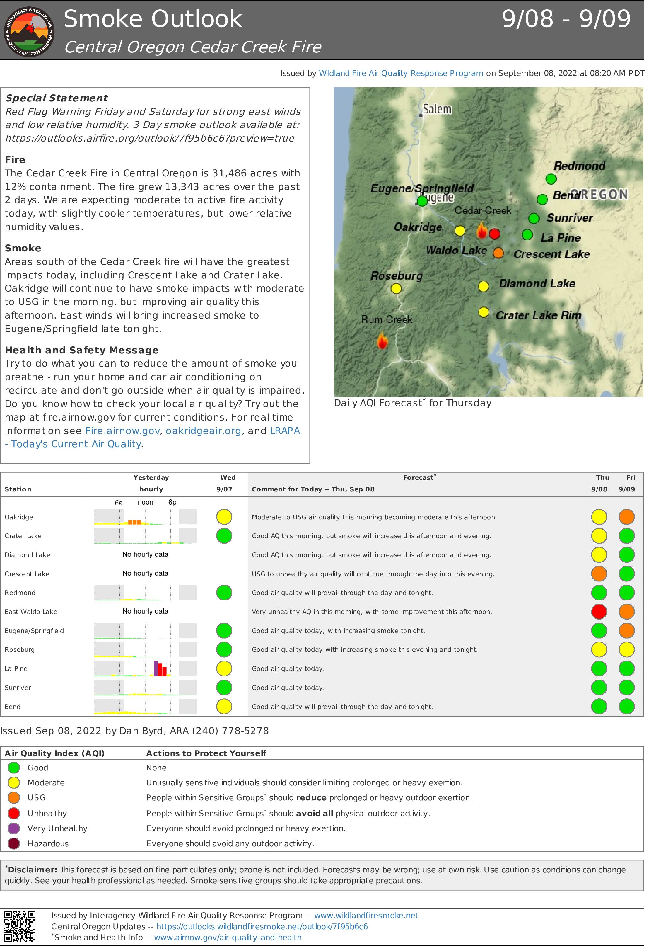
Cedar Creek Fire Smoke Outlook Sept 8
Related Incident: Cedar Creek Fire
Publication Type: News
Special Statement
Red Flag Warning Friday and Saturday for strong east winds and low relative humidity. 3 Day smoke outlook available at: https://outlooks.airfire.org/outlook/7f95b6c6?preview=true
Fire
The Cedar Creek Fire in Central Oregon is 31,486 acres with 18% containment. The fire grew 13,343 acres over the past 2 days. We are expecting moderate to active fire activity today, with slightly cooler temperatures, but lower relative humidity values.
Smoke
Areas south of the Cedar Creek fire will have the greatest impacts today, including Crescent Lake and Crater Lake. Oakridge will continue to have smoke impacts with moderate to USG in the morning, but improving air quality this afternoon. East winds will bring increased smoke to Eugene/Springfield late tonight.
Health and Safety Message
Try to do what you can to reduce the amount of smoke you breathe - run your home and car air conditioning on recirculate and don't go outside when air quality is impaired. Do you know how to check your local air quality? Try out the map at fire.airnow.gov for current conditions. For real time information see Fire.airnow.gov, oakridgeair.org, and LRAPA - Today's Current Air Quality.
En español
Aviso Especial
Aviso de Bandera Roja para viernes y sábado debido avientos fuertes del este y baja humedad relativa. Vea la perspectiva de humo de 3 días en: https://outlooks.airfire.org/outlook/7f95b6c6?preview=true
El incendio Cedar Creek en el centro de Oregón tiene 31,485 acres y está contenido en un 12%. El incendio creció 13,343 acres durante las pasadas 2 semanas. Se espera una actividad de fuego moderada hoy, con temperaturas un poco más bajas, pero valores de humedad relativa más bajos.
Humo
Las áreas al sur del incendio Cedar Creek tendrán los mayores impactos hoy, incluyendo Crescent Lake y Crater Lake. Oakridge continuará teniendo impactos de humo con condiciones entre Moderado e IGS por la mañana, pero mejorando la calidad del aire esta tarde. Los vientos del este traerán más humo a Eugene/Springfield esta noche.
Mensaje de salud y seguridad
Intente hacer todo lo que pueda para reducir la cantidad de humo que respira: ponga en circulación el aire acondicionado de su casa y su automóvil y no salga al exterior cuando la calidad del aire se vea afectada. ¿Sabe cómo verificar la calidad del aire local? Pruebe el mapa en fire.airnow.gov para conocer las condiciones actuales. Para obtener información en tiempo real, consulte fire.airnow.gov, oakridgeair.org y LRAPA - Calidad del aire actual.
Updated Willamette National Forest Closure Order Sept 7
Related Incident: Cedar Creek Fire
Publication Type: News
Willamette National Forest Closure Order
September 7, 2022
Map: https://tinyurl.com/2p8c2bnb
Officials have expanded the emergency area closure for the Cedar Creek Fire on the Willamette National Forest and the U.S. Forest Service-Deschutes National Forest. The closure is implemented for the protection of public and firefighter health and safety. This closure includes several roads, trails and areas on the Willamette National Forest, including:
CLOSED Campgrounds:
• North Waldo Campground
• Gold Lake Campground
• Islet Campground
• Skookum Creek
• Blair Lake Campground
• Shadow Bay Campground
• Taylor Burn Campground
CLOSED Trails:
• Bobby Lake #3663
• Swan Lake #3570
• Charlton Lake #3593
• Cupit Mary Meadow #3560
• North Waldo Shoreline Tie #3590.1a
• Jack Pine Way #3587
• Warm Springs #3582
• Koch Mountain #3576
• Spirit Lake #3584
• Fisher Creek #3565
• Gold Lake #3677
• Williams Lake #3589
• Owl Cabin Way #3571
• Waldo Meadows #3591
• Eugene To Pacific Crest #3559
• Verdun #3686
• Whig And Torrey Way #3581
• Judy Lake #3575
• Crossing Way #3307
• Salmon Lakes #3585
• Black Creek #3551
• Fuji Mountain #3674
• Eastern Brook Lake #3552
• Mcbee #3523
• Pacific Crest Trail #2000
• Betty Lake #3664
• Six Lakes #3597
• Klovdahl #3692
• Skyline Bike #4383
• Waldo Mountain #3592
• Shale Ridge #3567
• North Fork Segment #5 #3666.5
• Marilyn Lake #3689
• Winchester Lake #3594
• Bunchgrass Tie #3558
• Helen Lake #3577
• Gander Lake #3568
• Harralson Tie #4364.1
• Irish Mountain #3588
• Box Canyon #3660
• Waldo Ridge #4390
• Taylor Butte #3580
• Rigdon Lakes #3555
• Jim Weaver Loop (Waldo Lake) #3590
• Upper Quinn #3597.1
• High Divide #3572
• Blair Lake #3553
• The Twins #19.1
• Wahana #3583
• Moolack Lake #3578
• Taits Loop North Bike Tie #4386.1
• North Waldo Shoreline #3590.1
• South Waldo #3586
• Field Lake #3579
• Mount Ray #3682
• Twins Peak #3595
• Constitution Grove #3675
• Shadow Bay Shoreline #3590.2
• Winchester Ridge #3596
• Maiden Peak #3681
• Roaring River Ridge #3312
• Mule Mountain #3553.2
• Harralson #4364
• Joe Goddard's Nature Trail #3690
• Erma Bells #3563
CLOSED Trailheads:
• Maiden Peak Trailhead
• Taylor Burn Trailhead
• Fisher Creek Trailhead
• Gold Lake Trailhead
• Verdun Trailhead
• Winchester Ridge Trailhead
• Blair Lake Trailhead (East)
• Blair Lake Trailhead (West)
• Marilyn Lakes Trailhead
• North Fork (Road 1944) Trailhead
• North Fork (Shale Ridge) Trailhead
• Roaring Ridge Trailhead (Lower)
CLOSED Recreation Sites:
• Maiden Peak Cabin
• Islet Boat Launch
• North Waldo Boat Launch
• Landis Cabin
• Box Canyon Guard Station
• Diamond Peak Vista Point
• Gold Lake Boat Launch
• Shadow Bay Boat Launch
• South Waldo Shelter
• Gold Lake Shelter
• Fuji Shelter
CLOSED Roads (see closure order for full list):
• Forest Road 2417
• Forest Road 1934
• Forest Road 19 (Aufderheide Drive) from milepost 20 (just east of Kiahanie Campground) to milepost 35 (south of Roaring River Campground).
Find a detailed map and the full text of the closure order for the Cedar Creek Fire: https://tinyurl.com/2p8c2bnb. Campfires are prohibited on the Willamette National Forest due to high fire danger and ongoing active fires.
NEW EVACUATION LEVELS Sept 7 418PM
Related Incident: Cedar Creek Fire
Publication Type: Announcement
CEDAR CREEK FIRE EVACUATION INFORMATION FOR DESCHUTES COUNTY
September 7, 2022 4:18PM
Below are the updated evacuation levels for Deschutes County due to the Cedar Creek Fire. For detailed information on evacuation areas go to deschutes.org/emergency.
Level 3 - GO NOW
• Areas east of the Lane County/Deschutes County Line, North of the Klamath County/Deschutes County line, northwest side of Wickiup Reservoir, the area surrounding Crane Prairie Reservoir and south of 6 Lakes Trail and Lava and Little Lava Lakes to include: o Cultus Lake Lodge and Campground o Little & Big Cove Boat-In Campground o West Cultus Boat-In Campground o Little Cultus o Cultus Mountain o Crane Prairie Reservoir o Brown's Mountain o Lemish Butte o Ketchketch Butte o Johnny Lake
Level 2 - BE SET
• North of the line delineating Township 20S from Township 19S, east of the Lane County/Deschutes County line, south of 6 Lakes Trail, and west of Cascade Lakes Highway to include o Lucky Butte o Williamson Mountain o Winopee, Snowshoe, Senoj, Big Finger, Upper Snowshoe, Long, Puppy, Leech, Goldeneye, and Lucky Lakes • The northwest side of Davis Lake
Level 1 - BE READY
• The area surrounding Lava and Little Lava Lakes Deschutes County 911 will be using wireless emergency alerts (WEA) to reach visitors in the evacuation areas that may not be signed up for Deschutes Alerts.
Cedar Creek Fire Smoke Outlook Sept 7
Related Incident: Cedar Creek Fire
Publication Type: News
Smoke Outlook Sept. 7
Special Statement
Fire Weather Watch for Friday and Saturday. 3 Day Smoke outlook available at: https://outlooks.airfire.org/outlook/7f95b6c6?preview=true
Fire
We are expecting active fire behavior today, with hot temperatures, low relative humidity values and an unstable atmosphere.
Smoke
Areas east of the Cedar Creek fire will continue to have the greatest smoke impacts with La Pine and Sunriver in the USG range. Redmond and Bend will have moderate impacts. Oakridge will continue to have smoke impacts today with USG to unhealthy this morning into the afternoon hours. Health and Safety Message Try to do what you can to reduce the amount of smoke you breathe - run your home and car air conditioning on recirculate and don't go outside when air quality is impaired. Do you know how to check your local air quality? Try out the map at fire.airnow.gov for current conditions. For real time information see Fire.airnow.gov, oakridgeair.org, and LRAPA - Today's Current Air Quality.
En Español
Vigilancia por Condiciones del tiempo para incendios para el viernes y el sábado. Vea la perspectiva de humo de 3 días en: https://outlooks.airfire.org/outlook/7f95b6c6?preview=true
Incéndio
Se espera una actividad de fuego activa hoy, con temperaturas muy calientes, valores de humedad relativa bajos y una atmósfera inestable.
Humo
Las áreas al este del incendio Cedar Creek continuarán teniendo los mayores impactos de humo hoy, con La Pine, y Sunriver en IGS. Redmond y Bend tendrán impactos moderados. Oakridge continuará teniendo impactos de humo hoy con calidad de aire entre IGS e Insalubre desde la mañana hasta horas de la tarde.
Mensaje de salud y seguridad
Intente hacer todo lo que pueda para reducir la cantidad de humo que respira: ponga en circulación el aire acondicionado de su casa y su automóvil y no salga al exterior cuando la calidad del aire se vea afectada. ¿Sabe cómo verificar la calidad del aire local? Pruebe el mapa en fire.airnow.gov para conocer las condiciones actuales. Para obtener información en tiempo real, consulte fire.airnow.gov, oakridgeair.org y LRAPA - Calidad del aire actual.
Actualizacin diaria en Espaol Incendio de Cedar Creek 7 de Sept
Related Incident: Cedar Creek Fire
Publication Type: News
Incendio de Cedar Creek
septiembre 7, 2022
Actualización diaria – 10:00 AM
Datos rápidos del Incendio Cedar Creek
Tamaño: 18,143* acres
Contenido: 12%
Fecha de inicio: 1 de agosto de 2022
Ubicación: 15 millas al este de Oakridge, OR
Causa: Tormenta eléctrica
Personal total: 861
Recursos: 19 camiones de bomberos
16 tripulaciones
32 equipos pesados
7 helicópteros
*El vuelo infrarrojo no ocurrió el 6 de septiembre. La nueva superficie se actualizará en Inciweb cuando se pueda realizar un vuelo.
NUEVO NIVEL DE EVACUACIÓN: Las oficinas del alguacil del condado de Deschutes y el condado de Lane han aumentado sus niveles de evacuación para las áreas del lago Cultus y el embalse Crane Prairie Reservoir, además de los lagos McFarland y las áreas del sendero Elk Creek Trail. Clic para ver mapa.
Advertencia de bandera roja: Hoy, continua el aviso de bandera roja para condiciones de calor, secas e inestables sobre el área del incendio. Se espera que esta combinación de clima aumente la actividad de los incendios.
Junta para la comunidad: jueves 8 de septiembre, 7:00 PM. El tema de la junta se enfocará en el condado de Deschutes y el centro de Oregon, virtualmente en la página de Facebook de Cedar Creek Fire.
Situación actual: A partir de ayer por la tarde, el fuego avanzó hacia el norte y el noreste a través de la cicatriz de quemadura del incendio Charlton y se estima que está una milla al oeste del área del lago Cultus Lake. Fuegos pequeños fueron detectado entre 0.5 y 1 milla de distancia. Los bomberos pudieron mantener líneas en el borde sur a lo largo de carretera forestal 2417 y el borde noroeste a lo largo del sistema de senderos de Winchester. No se reportó crecimiento en el interior occidental. Un vuelo infrarrojo no ocurrió anoche; La nueva superficie se actualizará en Inciweb cuando se pueda realizar un vuelo. Los patrones meteorológicos pronosticados indican que el comportamiento del fuego aumentara. Los combustibles, como los liquen, son extremadamente secos y tendrán una probabilidad de ignición del 90%.
Actividades de hoy: El Alaska Incident Command Team 1, un equipo tipo 1 de comando de incidentes, se movilizará para manejar la parte este del Incendio Cedar Creek, al unísono con el Equipo 6 del Noroeste. La seguridad pública y de los bomberos seguirá siendo la prioridad número uno. Los bomberos en el borde noreste explorarán el crecimiento del fuego durante la noche y comenzarán a construir puntos de protección en el área del lago Cultus. Las cuadrillas en la parte norte del incendio trabajarán para asegurar la línea alrededor del sistema de senderos de Winchester y las líneas secundarias hasta carretera forestal 19 y más allá. En el borde sur, las cuadrillas continuarán manteniendo y mejorando carretera forestal 2421. Los bomberos cerca del borde suroeste del lago Waldo Lake continuarán agregando sistemas de rociadores para fortalecer la línea alrededor de arroyo Black Creek.
Clima: Continua el aviso de bandera roja. Se pronostica que las altas temperaturas alcanzarán los 90°F en elevaciones bajas y los 86°F en elevaciones más altas. Las velocidades del viento alcanzarán 6-8 mph con ráfagas de hasta 16 mph. Los vientos del sureste cambiarán a vientos del suroeste por la tarde. Los bajos niveles de humedad durante la noche permitirán una oportunidad de fuego extendida.
Cierres: El Bosque Nacional Deschutes y el Bosque Nacional Willamette han implementado cierres para el incendio de Cedar Creek. Visite la paginas Willamette National Forest y Deschutes National Forest para obtener detalles de las órdenes de cierre y un mapa conjunto. Una restricción temporal de vuelo (TFR) está en curso. Los excursionistas del sendero Pacific Crest deben visitar la página pcta.org para obtener información actualizada.
Restricciones: Existen restricciones contra incendios en el Bosque Nacional Willamette y el Bosque Nacional Deschutes, con la excepción de las áreas de Three Sisters, Mt. Jefferson, Mt. Washington, Waldo Lake y Diamond Peak Wilderness.
Humo: Las perspectivas de pronóstico de humo están disponibles en https://outlooks.wildlandfiresmoke.net/outlook.
Información sobre incendios: 8:00 AM – 8:00 PM | Teléfono: 541-201-2335 | Correo electrónico: 2022.cedarcreek@firenet.gov
En línea: https://inciweb.nwcg.gov/incident/8307/ | https://www.facebook.com/CedarCreekFire2022/ | https://www.facebook.com/willamettenf | https://twitter.com/willametteNF |
YouTube: https://www.tinyurl.com/cedarcreekfireyoutube
Evacuaciones: Los niveles de evacuación aumentaron anoche. Regístrese para recibir alertas móviles de emergencia en oralert.gov. Consulte con la Oficina del Sheriff del Condado de Lane 541-682-4150 y la Oficina del Sheriff del Condado de Deschutes 541-693-6911 para obtener actualizaciones y cambios. Consulta la pagina https://bit.ly/3ewJlUL para ver un mapa.
niveles de evacuación aumentaron para el incendio cedar creek
El aumento de la actividad de incendios ha provocado un aumento en los niveles de evacuación para las áreas alrededor del incendio de Cedar Creek. Además de todos los avisos de evacuación emitidos anteriormente que siguen vigentes, las oficinas del alguacil del condado de Deschutes y el condado de Lane han emitido los siguientes aumentos en el nivel de evacuación:
NIVEL 3 (VAYA AHORA) SE HAN EMITIDO AVISOS DE EVACUACIÓN PARA LAS SIGUIENTES ÁREAS:
· Áreas de evacuación de nivel 2 anteriores que incluyen Johnny Lake, Clover Meadow, Lemish Lake, el área de Many Lakes, al norte de la línea entre municipio Township 19 y Township 20 (aproximadamente el poste de la milla 40.5 en carretera Cascade Lakes Hwy).
· Todas las áreas al oeste de la carretera Cascade Lakes Hwy al norte de carretera forestal 4290 (Charlton Lake Road) al norte hasta el área del puente Deschutes. Esto incluye el lago Cultus Lake, Little Cultus Lake, Corral Swamp y las áreas alrededor de Lemish y Ketchketch Buttes.
· Áreas de los lagos McFarland y sendero Elk Creek Trail
¡El nivel 3 significa salir inmediatamente! NO se tome el tiempo para recoger las cosas. ¡VE AHORA! Existe un peligro inmediato e inminente y debe evacuar inmediatamente.
NIVEL 2 (ESTEBLECE) SE HAN EMITIDO AVISOS DE EVACUACIÓN DE NIVEL 2 PARA LAS SIGUIENTES ÁREAS:
· Áreas al oeste de la carretera Cascade Lakes Hwy y al sur de carretera forestal 4290 (Charlton Lake Road) al sur hasta la línea entre los municipios Township 21 y Township 22 (aproximadamente el poste de la milla 54 en carretera Cascade Lakes Hwy).
· Áreas entre los senderos Metolius – Windigo Trail/Six Lakes Trail y el borde del condado, incluidos lagos Winopee Lake, Snowshoe Lakes y Leech Lake.
· La cuenca Mink Lake Basin
Nivel 2 significa: debe prepararse para irse en cualquier momento, y este puede ser el único aviso que recibe.
NIVEL 1 (ESTE LISTO) SE HAN EMITIDO AVISOS DE EVACUACIÓN DE NIVEL 1 PARA LAS SIGUIENTES ÁREAS:
· Áreas alrededor del lado oeste de Crane Prairie desde Deschutes Bridge hacia el sur hasta carretera forestal 42 (South Century Drive), incluidos los campamentos Browns Mountain, Cow Meadow, Quinn Meadow y Rock Creek.
Nivel 1 significa: Este es el momento para la preparación y el movimiento preventivo de personas con necesidades especiales, bienes muebles, mascotas y ganado. Las personas deben tomar las mejores decisiones posibles para su seguridad.