
Prescribed Fire Community Meeting
Related Incident: Dorado/Cañada del Agua Prescribed Fire
Publication Type: Announcement
Learn and ask questions about the Dorado/Cañada del Agua Prescribed Fire
5:00 p.m. - 6:30 p.m.
Thu., Apr. 13, 2023
Tres Piedras Ranger Station
22280 Hwy 64
Tres Piedras, NM 87577
Hopkins Knob Prescribed Burn Update 516 pm 03302023
Related Incident:
Publication Type: Announcement
The Hopkins Knob Prescribed Burn is complete as of 5:04 p.m. A total of 837 acres were treated with prescribed fire. Fire staff will monitor the area tonight and tomorrow as needed.
Hopkins Knob Prescribed Burn Update 1203 pm 03302023
Related Incident:
Publication Type: Announcement
Prescribed burning at Hopkins Knob has resumed today as of 11:47 a.m.
Texas Summit Fire Closures 3292023
Related Incident:
Publication Type: Closures
Texas Canyon Rest Stop is temporarily closed.
For all road information, check with Arizona Department of Transportation OR call 511.
Hopkins Knob Prescribed Burn Update 730 pm 03292023
Related Incident:
Publication Type: Announcement
Prescribed burning at Hopkins Knob has concluded for today as of 7:13 p.m., 292 acres were completed. Burning will continue tomorrow as long as weather conditions are favorable.
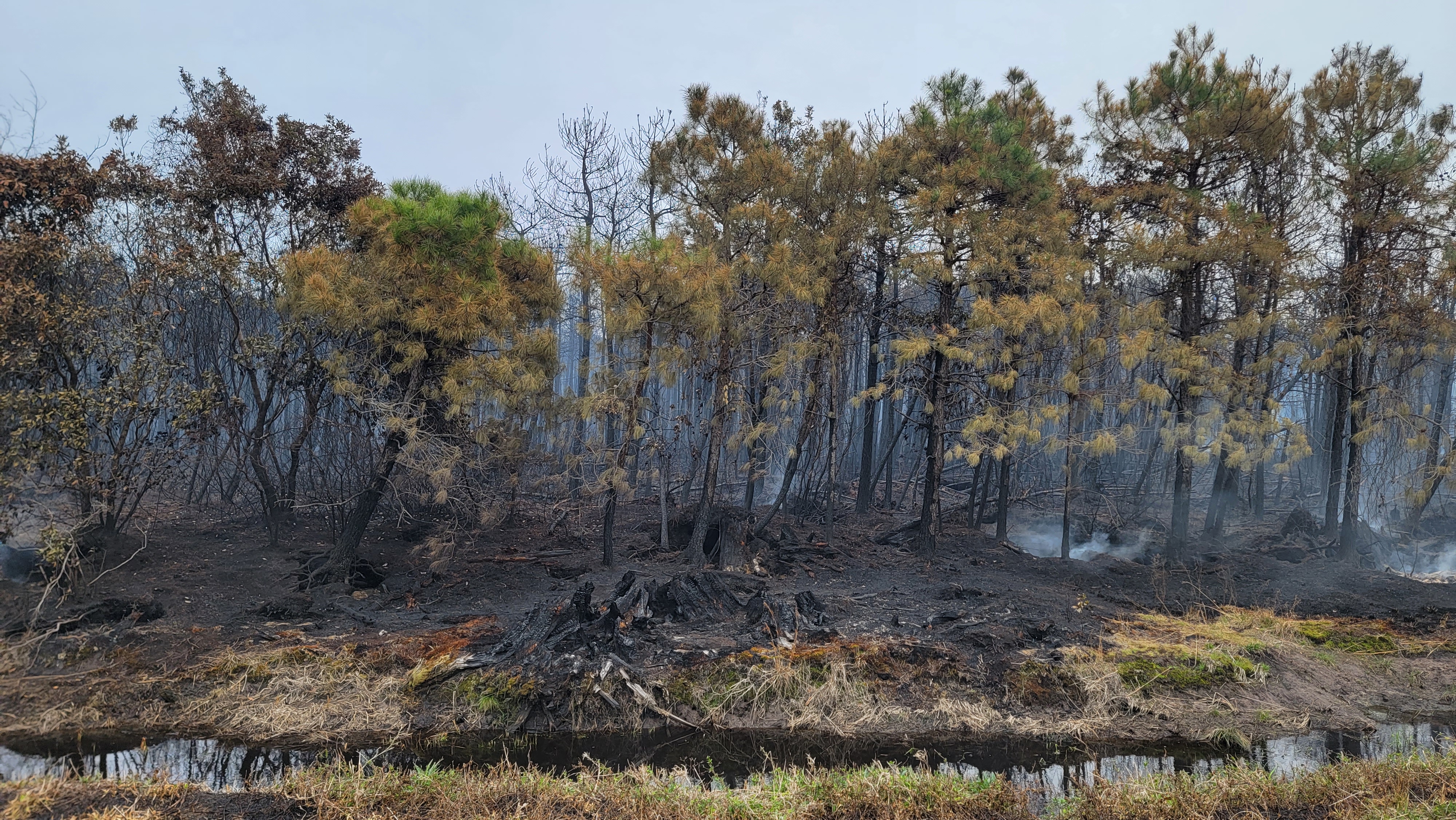
Last Resort Fire Daily Update March 29 2023
Related Incident: Last Resort Fire
Publication Type: News
FOR IMMEDIATE RELEASE
WEDNESDAY, MARCH 29, 2023
CONTACT: Philip Jackson, public information officer
919-857-4828 or philip.jackson@ncagr.gov
![]()
![]()
Last Resort Fire in Tyrrell County remains 48% contained
CRESWELL – Due to more accurate mapping, the Last Resort Fire in Tyrrell County is now 5,293 acres in size and remains 48% contained as of 4 p.m., March 29.
Infrared (IR) flights will continue to evaluate the extent of ground fire as personnel finalize a plan to utilize nearby fresh water sources to minimize loss of organic soil. Both fire and salt water will destroy peat soils. Protecting pocosins is foundational to healthy ecological and human communities. IR drone flights conducted Tuesday night revealed additional hot spots in the southeast fire area near Western Road.
To protect the organic peat soils, reduce smoke impacts and prevent reburn, irrigation systems are in place and water pumping operations have begun.
Communities between Plymouth, Columbia and Belhaven can expect smoke impacts overnight and into Thursday morning. Significant smoke is possible and may result in challenging travel conditions.
In the interest of safety, residents and commuters may want to consider allowing for extra travel time or plan to take alternate routes. Overnight, a combination of smoke and fog could lead to low visibility in some areas.
Those commuting Thursday morning should remain alert and attentive to signage. Road closures may be implemented as needed.
Operational resources working the fire include 72 personnel from the N.C. Forest Service and U.S. Fish and Wildlife Service.
There are no injuries and no structures threatened at this time. The cause of the fire was determined to be a debris burn on private land that escaped containment.
A temporary flight restriction (TFR) has been issued for the Last Resort Fire. The TFR restricts all civilian aircraft, manned and unmanned, within 5 miles of the fire. The flight restriction remains in place until aviation support is no longer needed.
For information updates, visit https://inciweb.wildfire.gov/incident-information/ncpor-last-resort-fire
Last Resort Fire Daily Update March 28 2023
Related Incident: Last Resort Fire
Publication Type: News
FOR IMMEDIATE RELEASE
TUESDAY, MARCH 28, 2023
CONTACT: Philip Jackson, public information officer
N.C. Forest Service
919-857-4828 or philip.jackson@ncagr.gov
![]()
![]()
Last Resort Fire now 5,384 acres in size and 48% contained
CRESWELL – The Last Resort Fire in Tyrrell County is now 5,384 acres in size and 48% contained as of 4 p.m., March 28.
Overnight infrared (IR) drone flights revealed significant heat in the fire area. IR flights will continue to evaluate the extent of ground fire as personnel develop a plan to utilize nearby fresh water sources to minimize loss of organic soil. Both fire and salt water will destroy peat soils. Protecting pocosins is foundational to healthy ecological and human communities.
To protect the organic peat soils, reduce smoke impacts and prevent reburn, irrigation systems are being staged for water pumping operations to begin in the coming days.
Significant smoke is possible and may result in tedious travel conditions. Communities southeast of the fire near Greenville, Beaufort and Little Washington can expect smoke impacts overnight. Communities south of the fire area near Belhaven, Pantego, Fairfield and Swan Quarter can expect smoke impacts early Wednesday morning.
In the interest of safety, residents and commuters may want to consider allowing for extra travel time or plan to take alternate routes. Overnight, a combination of smoke and fog could lead to low visibility in some areas.
Those commuting Wednesday morning should remain alert and attentive to signage. Road closures may be implemented as needed.
Operational resources working the fire include 67 personnel from the N.C. Forest Service and U.S. Fish and Wildlife Service.
There are no injuries and no structures threatened at this time. The cause of the fire was determined to be a debris burn on private land that escaped containment.
A temporary flight restriction (TFR) has been issued for the Last Resort Fire. The TFR restricts all civilian aircraft, manned and unmanned, within 5 miles of the fire. The flight restriction remains in place until aviation support is no longer needed.
For information updates, visit https://www.ncforestservice.gov/fire_control/sit_report.htm.
Hopkins Knob Prescribed Burn Update 130 pm 03292023
Related Incident:
Publication Type: Announcement
Prescribed burning is underway at Hopkins Knob near Blue Bend. A helicopter is onsite and will be used to assist with ignition. Test fire completed at 12:17 p.m. and full ignition began at 12:40 p.m.
Cranston Reforestation Prescribed Burn San Jacinto Ranger District Evening Update 32823
Related Incident: 2023 - San Bernardino National Forest Wildfire Crisis Response
Publication Type: News
March 28, 2023 - Evening Update – Today’s burn operations have concluded, there may still be smoke visible through the night, all piles are holding in place. This will be in patrol status and monitored. There was a total of 10 acres accomplished.
#PrescribedBurn #PrescribedFire #ForestHealth #CranstonReforestationPrescribedBurn