
Red Fire Daily Update 07222024 07 22 2024
Related Incident: Red Fire
Publication Type: News
RED FIRE UPDATE
July 22, 2024
Fire Information Line - 541-316-7711
centraloregonfire.org x.com/CentralORFire
Inciweb: https://inciweb.wildfire.gov/incident-news/ordef-red-fire
Size: 256 acres | Location: 5 miles west of Crescent Lake Junction, Oregon
County: Klamath | Start Date: July 17, 2024 | Containment: 0% | Cause: Lightning
Total Personnel: 130
Klamath County, Oregon — The Red Fire is located within the Diamond Peak Wilderness on the Deschutes National Forest, on the southwest slope of Redtop Mountain. The fire is being managed under a full suppression strategy. The Southern Area Gray Incident Management Team, led by Incident Commander Fulton Jeansonne, assumed command of the fire on Friday, July 19, at 6:00 a.m. local time. Public and firefighter safety is the highest priority in managing this fire.
The Diamond Peak Wilderness encompasses 52,500 rugged acres straddling the crest of the Cascade Mountains. It was designated in 1964 by the Wilderness Act, to be stewarded in its natural, undeveloped condition. Motorized equipment, motor vehicles, and aircraft are prohibited in Wilderness by federal law, with narrow criteria for exceptions. The USDA Forest Service has authorized the use of chain saws, portable pumps, fire retardant, and aircraft landings by firefighters on the Red Fire since initial attack.
At 8:00 p.m., on Sunday, July 21, the Southern Area Gray Incident Management Team also assumed command of the Jackpine Fire located in Klamath and Deschutes counties. Firefighters continue to work in full suppression strategy. Additional information is available in a separate Jackpine Fire Daily Updates.
Yesterday’s Activities – Firefighters continued to assess and scout opportunities for containment lines in the Wilderness. Structure assessment work was completed in the area of Odell Lake, Crescent Lake Junction, and Crescent Lake. Construction of a shaded fuel break continued along the west side of the Union Pacific Railroad tracks and the north side of Forest Service Road 60. The reduction in acreage is due to more accurate mapping based on an infrared flight.
Today’s Activities – Firefighters will continue to assess and scout opportunities for control features in the Wilderness. Construction of the shaded fuel break will continue along the west side of the Union Pacific Railroad tracks and the north side of Forest Service Road 60, west of the community of Crescent Lake Junction.
Weather – Mostly sunny with haze throughout the day. High temperature near 75, minimum humidity 35-45 percent. Winds light in the morning, then west to northwest 4-8 mph with gusts to 20 mph in the afternoon.
Community Meeting – A Red Fire Community Meeting has been scheduled for Monday, July 22, at 6:00 p.m. at: Central Cascades Fire & EMS Community Service Center, 20400 Crescent Lake Hwy, Crescent Lake, OR 97733.
Evacuation Notice – WILDFIRE! Level 1 - BE READY to evacuate.
Klamath County Emergency Management has issued a WILDFIRE! Level 1 - BE READY to evacuate notice for the following areas: Crescent Lake, Odell Lake, Crescent Junction.
Klamath County Emergency Management. INCENDIO FORESTAL! Nivel 1 - ESTÉ PREPARADO para evacuar de las siguientes zonas: Crescent Lake, Odell Lake, Crescent Junction.
Plan to go to the Crescent Community Club if a Level 3: Go Now! evacuation is issued. There will be more information, respite, and disaster case management in-processing. ADA: Yes.
Fire Restrictions – Public use fire restrictions are currently in effect for the Deschutes National Forest. Visit CentralOregonFire.org or the Deschutes National Forest’s website (fs.usda.gov/detail/deschutes/home/?cid=stelprdb5297376) for more information.
Air quality information can be found at https://fire.airnow.gov/.
A Temporary Flight Restriction is in place over the fire area. If you fly, we can’t. Unauthorized drone flights (UAS) pose serious risks to firefighter and public safety and the effectiveness of wildfire suppression operations. Aerial firefighting is suspended when unauthorized UAS are in the area, allowing wildfires to grow larger.
Romero Fire Update 07 22 2024
Related Incident: Romero
Publication Type: News
Romero Fire Update Monday, July 22, 2024
Start Date: Friday, July 19, 2024 Cause: Undetermined
Location: 13 miles southwest of Kearny Acres: 7,000
Personnel Assigned: 181 Containment: 30%
Evacuation: SET for 3C Ranch
Summary: The Romero Fire is at 7,000 acres and 30% containment. Yesterday, firefighters on the Romero Fire worked to strengthen and improve containment lines along Freeman Rd, up to the structures in Haydon Ranch. The Cottonwood Wash is a natural feature on the east side that crews are utilizing as a natural fuel break to prevent further spread to the east. Aircraft were utilized for the majority of the day to suppress further spread to the east and north. A helicopter was utilized for multiple flights over the fire for reconnaissance and a mapping mission. A dozer and multiple handcrews spent the day constructing line around the north portion of the fire with the object to prevent further spread. This work was done in conjunction with a firing operation to strengthen and improve the containment line, securing the northeast corner by tying it into the Cottonwood Wash.
A sever thunderstorm moved into the area early Sunday evening. The storm produced strong, erratic outflow winds that impacted the fire area with low visibility and gusts up to 50 mph. Resources were pulled off the fireline for safety with a few overhead remaining in the fire area late into the evening to monitor fire behavior. No moisture was received over the fire area from the passing storm.
Today, a second dozer will assist with line construction on the northwest corner of the fire. Residents in the surrounding communities should expect to see an increase in smoke throughout the day. Crews will continue to patrol the southern end of the fire and address any pockets of heat remaining on the fire’s edge. Along the eastern edge, crew objectives are to go direct where it is safe to do so. Aircraft remain available to support the fire for recon and suppression efforts.
Due to the proximity of the fire to the 3C Ranch west of the fire, near Barkerville Rd, fire operations made the decision to place the ranch in SET evacuation status. That evacuation remains in place. Residents in Pinal County can sign up for emergency alert notifications at: https://www.pinal.gov/1335/PENS---Pinal-Emergency-Notification-Syst.
Closures: Freeman Road is closed. Deputies will be placed at roadblocks throughout the fire area. The public is asked to avoid the fire area, including Barkerville and Willow Springs Road. The AZT (Arizona Trail) is closed between Oracle and Kearny. Hikers should plan an alternate route.
Weather: Weather is expected to be the same as the past two days. Expect mostly sunny skies, becoming cloudy in the afternoon. Thunderstorms with lightning and strong, erratic outflow winds remain a concern in the afternoon.
Safety: A TFR (Temporary Flight Restriction) is in place over the fire. Firefighting aircraft and drones are a dangerous combination. Drones in the area could lead to accidents or slow down wildfire suppression operations. If you fly…we can’t.
Fire Restrictions: Stage 1 fire restrictions in effect on State Trust lands in Pinal County. Restriction info: http://wildlandfire.az.gov/
Incident Information: https://inciweb.wildfire.gov/incident-information/aza3s-romero
Twitter: @azstateforestry: https://twitter.com/azstateforestry
Facebook: Arizona Department of Forestry and Fire Management: https://www.facebook.com/arizonaforestry
Ready, Set, Go: https://ein.az.gov/ready-set-go
Easy Fire Update 07 22 2024
Related Incident: Easy Fire
Publication Type: News
Easy Fire Update for July 21, 2024
Incident Commander Lonnie Click
Complex Incident Management Team Northwest 3
(541) 861-5808, staffed 8 a.m. to 8 p.m. 2024.pioneer@firenet.gov
Quick Facts
Size: 345 acres
Start Date: July 17, 2024
Location: 17 miles west of Mazama, WA
Containment: 0%
Cause: Lightning
Resources Assigned: 1 crew, 3 helicopters, 5 engines
CURRENT SITUATION: Easy Fire is burning in dense timber and extremely steep terrain. The fire is backing and flanking with short upslope runs, single tree torching, and short-range spotting. The steep slopes with continuous timber contribute to difficulty with fire suppression. Easy fire is a full suppression fire and firefighters are utilizing strategies and tactics that provide the highest likelihood for success while mitigating risks to firefighters and the public.
Easy Fire extends over Mt. Hardy, threatening the Pacific Crest Trail, while also moving down slope toward State Route 20 (SR 20) North Cascades Highway.
State Route 20 is closed in both directions between Granite Creek (MP 148) and Easy Pass Trailhead (MP 157). Ground crews are removing dead trees between the active fire edge and SR 20 to help limit fire spread in that direction. This work, along with the very active fire behavior, necessitates a closure to protect the public from hazards like falling trees or rocks along with fire growth.
Helicopters assisted firefighters Sunday morning with water bucket drops to slow the spread of Easy Fire. Hot, dry, and unstable weather conditions led to very active burning and visible smoke columns from the Easy Fire during the afternoon and evening.
TODAY’S ACTIVITIES: Extreme terrain prevents direct attack. Instead, firefighters are identifying and establishing indirect firelines that take advantage of natural barriers such as avalanche chutes. Firefighters will continue snagging operations above and parallel Highway 20 and continue work to establish safe access to the right and left flanks of Easy Fire. Crews are actively establishing fireline and setting up sprinkler systems.
WEATHER: Critical weather conditions continue to contribute to very active fire behavior. The National Weather Service has issued an Excessive Heat Warning through Monday at 8 pm. A Red Flag Warning is in place for hot dry, and unstable conditions today. Temperatures will remain in the upper 90s to low 100s with cooling expected early next week.
EVACUATIONS: There are no evacuations in place for the Easy Fire. Anyone recreating in the area should be vigilant about being aware of surroundings and stay out of closed areas. Please visit https://t.ly/QoH9w for more information about evacuation levels.
FOREST CLOSURE: The Okanogan-Wenatchee National Forest has closures in place for trails within the fire area: https://bit.ly/EasyFireClosures. Campfires are prohibited. There is a Temporary Flight Restriction (TFR) in place over the fire: https://tfr.faa.gov/save_pages/detail_4_6779.html. Unauthorized drone activity is prohibited under the TFR.
Facebook: https://www.facebook.com/profile.php?id=61560760893080
Fire Information Line: 541-861-5808, 8 AM to 8 PM
Email: 2024.pioneer@firenet.gov
Pioneer Fire Update 07 22 2024
Related Incident:
Publication Type: News
Pioneer Fire Update for July 22, 2024
Incident Commander Lonnie Click
Complex Incident Management Team Northwest 3
(541) 861-5808, staffed 8 a.m. to 8 p.m. 2024.pioneer@firenet.gov
Quick Facts
Size: 30,352 acres
Start Date: June 8, 2024
Location: 31 miles NW of Chelan, WA
Containment: 14%
Cause: Human-caused, under investigation
Personnel: 776
Resources Assigned: 11 crews, 4 helicopters, 25 engines, 28 water tenders, 18 heavy equipment
There will be a Stehekin community meeting Tuesday at 5 PM at the Golden West Visitor Center. There will also be a Manson community meeting Wednesday at 5:30 PM at the Manson High School. The meeting in Manson will be streamed live on the Pioneer Fire Information Facebook page. Please submit questions in advance to 2024.pioneer@firenet.gov or via Facebook Messenger.
CURRENT SITUATION: Firefighters and equipment from State Fire Assistance for Stehekin are arriving today. They will be implementing Structure Protection Plans and further preparing structures and infrastructure for increased fire resilience. The fire continues to advance toward Flick Creek on the northern flank and has been active in the upper drainages of Fish Creek and Prince Creek on the eastern edge of the fire. Fire growth is expected today with the predicted temperatures, humidity and gusty winds. On the south end of the fire, firefighters continue to be on the lookout for fire activity in the Lone Fir drainage, which has seen little movement in recent days.
TODAY’S ACTIVITIES: The contingency lines between the fire and Manson along Coyote Ridge and Nelson Ridge have been completed and hose lays are installed. Testing of those hose-lays and line improvements will continue today. Work along Cooper Ridge to prepare it as an indirect fireline is nearing completion. A group of boats is moving firefighters and equipment to remote areas along the lake edge. A fire module with a UAS (drone) is working along the northern part of the fire to detect hot spots along the edge and complete strategic firing operations when needed for protection of cabins and infrastructure. Helicopters will continue to support firefighting efforts.
WEATHER: An approaching cold front is expected to shift winds to the west-northwest this afternoon. Gusts approaching 25 miles per hour and humidity dropping to around 25% prompted a Red Flag Warning for today. Active fire behavior, such as torching and possible crown fire runs, is expected due to the critical weather situation. Some smoke columns may be visible.
EVACUATIONS: Level 1, 2 and 3 evacuation levels remain in effect around the Pioneer Fire. Please visit https://t.ly/QoH9w for more information.
FOREST CLOSURE: Current closures for the North Cascades National Park: https://www.nps.gov/noca/index.htm. The Okanogan-Wenatchee National Forest has a closure order in place for much of the fire area: https://bit.ly/PioneerClosure. Campfires are prohibited. There is a Temporary Flight Restriction (TFR) in place over the fire: https://tfr.faa.gov/save_pages/detail_4_6779.html. Unauthorized drone activity is prohibited under the TFR.
InciWeb: https://inciweb.wildfire.gov/incident-information/wases-pioneer
Facebook: https://www.facebook.com/profile.php?id=61560760893080
Fire Information Line: 541-861-5808, 8 AM to 8 PM
Email: 2024.pioneer@firenet.gov
Hill Fire Morning Update 07 22 2024
Related Incident: Hill Fire
Publication Type: News
HILL FIRE INCIDENT UPDATE Date: July 22, 2024
Fire Information: 530-414-9056 or dial 211 Hours: 08:00AM to 8:00PM
Location: Humboldt County, CA
Size: 5582 acres
Cause: Under Investigation
Email: 2024.Hill@firenet.gov
Incident Website: https://inciweb.wildfire.gov/incident-information/casrf-hill-fire
https://www.fire.ca.gov/incidents/2024/7/16/hill-fire
Start Date: Monday July 15, 2023, at 5:40 PM
Percent Contained: 7%
Personnel: 1995
CURRENT SITUATION:
Yesterday, on the east side of the fire crews made significant progress with tactical firing operations along 6NO6 Forest Road to increase the depth of the fireline and eliminate pockets of fuel that could threaten its integrity. The operation continued southward from the 5NO1A Road, moving towards the south end of the fire in the Mosquito Creek drainage. Progress was made in the southwest area of the fire with handline and hose lines in place. Continuing north crews continued to secure the lines and mop up any hot spots. The spot fires in the northwest area did not show significant fire behavior or growth, and crews continue secure the perimeter.
Today, firefighters will utilize appropriate tactical firing operations to strengthen control lines and patrol perimeter to identify and mitigate the potential for escape outside of established control lines on the east side of the fire. Heavy equipment and hand crews completed the fire line along the south end of the fire in the Mosquito Creek drainage out to 6NO6 Road. The west and north flanks of the fire continue to stay within their current footprint, and crews will be patrolling and extinguishing hotspots near the fires edge. There are still pockets of unburned fuel within the fire perimeter. As these pockets continue to burn and smolder, residents will continue to see smoke coming from the fire area. The structure defense group continues to collaborate with local fire departments to assess residences in the area and develop a structure defense plan. Crews are also looking beyond the current fire lines and developing contingency strategies in case the fire breaches containment lines.
WEATHER:
A strong short-lived heat wave will begin to quickly build today with highs cresting into the 90s and RH dropping back below 30 percent. The high pressure will bring a return to very poor RH recoveries at height elevations tonight alongside enhanced drainage winds. Heat will peak on Tuesday with very dry conditions and areas approaching 100.
EVACUATIONS: Evacuation order and warnings remain in effect. For current updates on evacuations, visit https://www.facebook.com/HumboldtSheriff and https://humboldtgov.org/2383/Current-Emergencies.
Conditions are subject to change at any time, visit https://protect.genasys.com/search for a full zone description. Sign up for Humboldt Alert emergency notifications at https://humboldtgov.org/2014/Emergency-Notifications
CLOSURES:
Forest Closure Order currently in effect for the area impacted by the Hill Fire. It is temporarily prohibited to be on any national forest system land, trail, or road within the closure area. To view the closure order and map of closure area visit the following link www.fs.usda.gov/Internet/FSE_DOCUMENTS/fseprd1191963.pdf.
Road closures are currently in place on Friday Ridge Rd. at Forest Service Route 6N06, Friday Ridge Rd. at Forest Route 5N01 and Friday Fridge Rd. at Forest Route 5N04. For updated road closure information, visit protect.genasys.com or humboldtsheriff.org/emergency.
FIRE RESTRICTIONS:
Forest fire restrictions also went into effect on July 12th. Campfires and stove fires are restricted to those developed areas listed in the forest order located at https://www.fs.usda.gov/Internet/FSE_DOCUMENTS/fseprd1188610.pdf.
Smoking, welding, and operating an internal combustion engine also have restrictions in place.
Falls Fire Update07 22 2024
Related Incident: Falls Fire
Publication Type: News
Falls Fire Update for July 22, 2024
Size: 132,751 Start Date: July 10, 2024 Location: 13 Miles NW of Burns, Oregon
Containment: 40% Total Personnel: 1,655 Cause: Human-caused, under investigation
Structures Triaged: Residences: 284; Commercial: 85; Outbuildings: 460
Resources Assigned: 46 hand crews, 108 engines, 25 bulldozers, 32 water tenders
Aerial resources available to the fire: two helicopters, and single-engine air tankers (SEATS)
Yesterday, the fire became significantly more active in the afternoon compared to the previous three days. The Falls Fire was hit by a series of thunderstorms and strong southwesterly winds; outflows from these storms were reported at 25 miles per hour within the fire area and up to 50 miles per hour for surrounding areas. The many days of structure preparation work put into private property was tested and a success. The fire remains approximately 13 miles north of Burns, 11 miles southwest of Seneca, 7.5 miles south of Izee, and 2.5 miles west of Highway (Hwy) 395.
The fire protection plan was implemented at a ranch at the southernmost section of Forest Service Road (FSR) 63 near FSR 68. Structure and wildland crews worked together, building on the multiple days of surface prep, dozer line, fuel reduction, and other fire hardening preparations. Fire was used as a tool to stop forward progression of the fire. Crews were shifted from less impacted areas along the fire line to areas of critical need. Tactical firing operations were successfully used to secure previously constructed control lines around the ranch’s structures.
In the northwest corner of the fire, firefighters worked on securing line and mopping up spots over FSR 47. A tactical burnout operation was conducted last night near FSR 4785 (Coral Creek) to secure line near private properties. Resources continued constructing direct line with dozers and hand crews on FSR 4785 toward Burnt Mountain. Construction of secondary contingency (backup) dozer line was completed to the northwest near Snow Mountain along FSR 4781. Additional secondary dozer line going both north and south off FSR 4781 is now under construction. Along the eastern end of the northern flank, crews and dozers continued to establish control line to tie off fire east of FSR 47 back into FSR 3750. Oregon State Fire Marshal (OSFM) Task Forces were stationed near structures in the area of FSR 47, where fire was very active during the weather event on Sunday. Night crews patrolled the fire line, extinguishing hot spots and monitoring fire activity to ensure these structures remained unharmed. Firefighters scouted additional contingency dozer lines along FSR 3150 and FSR 3160 to connect to a series of roads near FSR 37 and FSR 31 into a continuous secondary control line running east-west north of the fire. In the northeast corner of the fire, a small tactical burnout operation was conducted in the evening east of FSR 31 and south of Myrtle Park Meadows to clean up a slop-over and strengthen control lines. Crews lined and controlled some additional spots in the area with support from helicopter bucket drops. Control lines along much of the southern portions of FSR 31 and west to FSR 43, continued to hold firm, despite windier conditions, as mop-up operations are ongoing.
Today, in the northwest corner, crews will look for opportunities to construct direct control lines to tie in slop-overs back into FSR 3750. Construction of secondary contingency dozer lines will continue along roads going north and south off of FSR 4781 from Snow Mountain. Near FSR 3750 and FSR 47, structure and wildland firefighters will continue to mop-up sources of heat along control lines and prepare for a small tactical burnout operation to secure a previous slop-over in that area. Firefighters will continue scouting for additional contingency dozer lines on the FSR 3150 and FSR 3160 to connect into the FSR 37 and FSR 31 road systems to establish a continuous secondary control line running east-west north of the fire. On the northeastern corner of the fire, just south of Myrtle Park Meadows, mop-up work will continue on a 200 acre slop-over along the FSR 31 Road. OSFM crews will support burnout operations and continue hardening surface prep at cabins and homes off FSR 37. In the southern and western sections of the fire, much of the established control line that extends from the southeast corner, over to the western flank of the fire, firefighters will continue to hold, improve, and mop-up control lines. Efforts to secure the Red Hill area will continue as well, with crews noting significant progress made in the past several days. Structures in this area are being hardened by OSFM crews ahead of an anticipated wind shift mid-week that will test control measures along the southern edge.
Further north, away from the fire perimeter, construction will continue on a planned secondary contingency line along FSR 37 just west of Hwy 395 in the Fisk Gulch area. This secondary contingency line is part of an alternate plan and will run east to west using portions of FSR 37 and FSR 31.
Fire weather includes a Heat Advisory for Monday with temperatures approaching 100 degrees. East winds will become variable around 11 AM, becoming southwesterly after 5 PM. Dry and unstable conditions will persist over the fire. Winds will become increasingly northwesterly after 10 PM. Due to the progress made in structural preparations over the past week; the Yamhill County Task Force is being reassigned to the Lone Peak fire this morning.
Evacuation notices remain in effect in Grant and Harney Counties. For the most accurate evacuation information, please visit the Harney County Sheriff’s evacuation map here: https://tinyurl.com/3zst4sjy, or the Grant County Emergency Management Facebook page at: https://www.facebook.com/profile.php?id=100068819321423.
The Malheur National Forest issued a fire area closure. A detailed map and additional information about the fire area closure are available at: https://www.fs.usda.gov/detail/malheur/news-events/?cid=FSEPRD1189259.
A temporary flight restriction (TFR) remains in place over the fire area.
U.S. Forest Service fire investigators are seeking the public’s assistance with any tips or information pertinent to the start of the Falls Fire on the Malheur National Forest. Please submit any information that could assist fire investigation efforts to SM.FS.R6TipHotLine@usda.gov.
Facebook: https://www.facebook.com/p/Falls-Fire-2024-61562126623985/
InciWeb: https://inciweb.wildfire.gov/incident-information/ormaf-falls-fire
Fire Information Line: 541-208-4370, staffed 8 a.m. to 8 p.m.
Email: 2024.Falls@firenet.gov
Harney County non-emergency evacuation questions: 541-589-5579
Air quality questions: 541-573-2271
Smoke Outlooks: https://outlooks.airfire.org/outlook
Durkee and Cow Valley Fire Update 07 22 2024
Related Incident: Durkee FireCow Valley Fire
Publication Type: News
Durkee, Cow Valley, and Bonita Fires Update for Monday, July 22, 2024
541-208-4371, staffed 7AM to 7PM PDT
DURKEE FIRE: Start date: July 17, 2024 | Location: 5 miles southwest of Durkee, OR | Personnel: 565 | Fire size: 173,759 acres | Cause: Lightning | Containment: 0%
Yesterday was another extremely active fire day. Winds from nearby thunderstorms started around 6 pm causing 50 mph out flow winds on the eastern section of the fire.
The fire pushed east between Rye Valley and Lockett Road toward I-84 causing additional evacuations. A link to current information road closure information is below.
Firefighters completed strategic firing operations from Bridgeport to Malheur Reservoir in partnership with resources from RFPAs (Rangeland Fire Protection Associations), Vale BLM (Bureau of Land Management), Rural Valley, OSFM (Oregon State Fire Marshal), and ODF (Oregon Department of Forestry.
Today, firefighters are working on connecting firelines into Deer Creek in the north. The Durkee Fire has burned into two past fire scars which will support personnel in their work by slowing fire spread and giving firefighters more time to connect firelines and conduct firing operations from. Aviation will continue to be an asset to crews by dropping water and retardant.
Critical burn environments continue across the Pacific Northwest causing an extreme potential for continued ignition.
COW VALLEY FIRE: Start date: July 11, 2024 | Location: 9 miles east of Ironside, OR | Personnel: 13 | Fire size: 133,490 acres | Cause: Human caused |Containment: 78%
Cow Valley has not showed any signs of heat or spread and is staying within its footprint even through windy conditions.
BONITA FIRE: Start date: July 11, 2024 | Location: 9 miles south east of Ironside, OR | Personnel: 0 | Fire size: 2,727 acres | Cause: Human caused |Containment: 90%
Minimal fire behavior has been observed due to suppression efforts, containment features and fuel consumption.
INVESTIGATION: Reward Offered for Information Relating to Wildfires in Malheur Reservoir Area
VALE, Ore. – Fire investigators and law enforcement officials are requesting the public’s assistance in the investigation of the Cow Valley, Bonita and other small wildfires in the Malheur Reservoir area.
These fires all began in the early morning hours of July 11, between approximately 1 and 5 a.m. They are believed to be human caused and of a suspicious nature. A monetary reward is being offered for information leading to the identification of individual(s) responsible. Anyone with information about any of these incidents should call We Tip Anonymous at 1-800-47-ARSON, online at wetip.com
WEATHER AND SMOKE: There is a Red Flag warning for lightning again today. The thunderstorms will bring outflow winds again starting late afternoon and could cause gusts up to 55 mph from any direction. For current smoke information, visit airfire.org
EVACUATIONS AND CLOSURES: The Malheur County Sheriff’s has issued evacuations for the area around Durkee Fire. check for updates on the Malheur County Sheriff’s Office Facebook page. The Baker County Sheriff’s Office has issued evacuations for the area around Durkee Fire. Visit the Baker County Sheriff’s Office Facebook page for more information. Baker County Sheriff's Office has closed Burnt River Canyon Road to non-local, non-emergency traffic due to the Durkee Fire.
I-84 and other Highways: Please go to tripcheck.com for current road closures as the situation is dynamic and subject to change.
BURN BAN: A burn ban is currently in effect for all of Malheur County, including all BLM lands. For more information, visit https://www.malheurco.org/category/public-notices/.
TEMPORARY FLIGHT RESTRICTION: There is a temporary flight restriction over the Durkee Fire, please remember, if you fly we can’t!
Durkee and Cow Valley Facebook Page
Battle Mountain Complex 07 22 2024
Related Incident: Battle Mountain Complex
Publication Type: News
Monkey Creek and Snake fires expected to merge
UKIAH, Ore. – Building off day-shift progress, night crews made big gains across the southern portions of the very-active Monkey Creek and Snake fires.
The Monkey Creek and Snake fires are both burning towards each other within the canyon rim of the North Fork John Day River within the steep terrain which is difficult for firefighters to access. In the river corridor, firefighters are focused on protecting homes and structures and building defensible space around them.
To the south of those fires, crews were able to connect dozer lines from the Snake River all the way across to the southeast section of the Monkey Creek Fire. Today, they will improve and hold those lines as the fire pushes toward them.
Firefighters successfully burned-out areas along the southeast of the Snake Fire. Vegetation is often lit between the established containment line and the main fire to halt its progress. On the north end of the Snake Fire, crews were able to lay hose and plumb water out across the line.
The 3,887-acre North Fork Owens Fire currently stands at 10% containment (the complex stands at 2% containment). Crews will continue mop-up operations and patrolling the perimeter.
Firefighters still face critical fire weather in the region and heavy smoke is making it difficult for helicopters to access some portions of the fire. In addition to the smoke from this complex, the area is inundated with smoke from fires across the region.
Closures: A road closure remains in effect for Highway 395, between mile posts 50 through 90, beginning 35 miles South of Pilot Rock.
Evacuations: Level 1 (Be Ready), Level 2 (Be Set) and Level 3 (Go Now) evacuations are in effect. For updated information, visit www.facebook.com/UmatillaCountySheriff, or sign up for the Umatilla County Emergency Alert System at https://member.everbridge.net/index/2590041373147145.
For current area fire info, go to http://bluemountainfireinfo.blogspot.com/ or ODF NEO Facebook: www.facebook.com/oregondeptofforestryNEO/. To report a fire, call Blue Mountain Interagency Dispatch at (541) 963-7171 or dial 9-1-1.
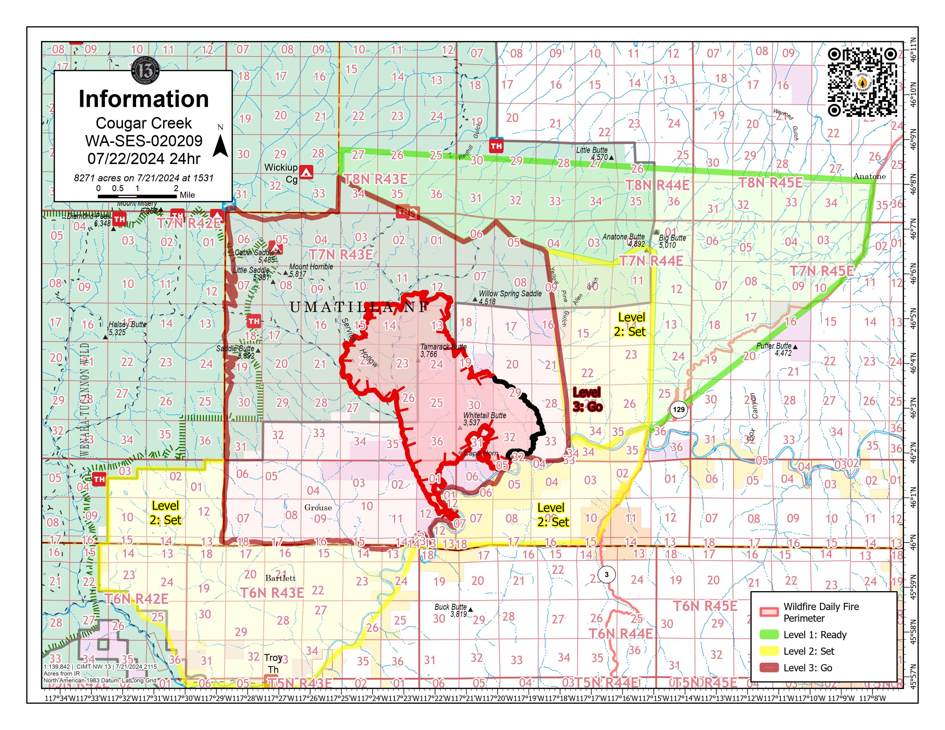
Cougar Creek Fire Update 07 22 2024
Related Incident: Cougar Creek Fire
Publication Type: News
Cougar Creek Fire Update for Monday July 22, 2024
KEY MESSAGE:
An Unmanned Aircraft System (UAS) is being utilized in the fire area to assist firefighters with infrared and mapping. Air operations continue to drop retardant and water to limit the progression of the fire and to secure the area around Grouse Flats. Further air resources were diverted to support firefighting efforts as activity increased in the afternoon. Morning smoke has generated visibility challenges, limiting aircraft availability.
CURRENT STATUS:
The previous days spot fire has progressed into the West Fork of the Wenatchee Creek drainage and is moving towards Grouse Flats where crews are heavily engaged with point protection efforts. Direct and indirect attack is being implemented and structure protection tactics are in place. A helibase was established in Anatone for better flight access to the fire area. Perimeter progression is expected to continue over the upcoming days due to limited access and extreme weather conditions.
FIRE BEHAVIOR AND WEATHER:
The fire is expected to progress uphill from the Wenatchee drainage and is heavily influenced by critical fire weather conditions, topography, fuel loading, and active fire behavior. An excessive heat warning remains through today. There is a small chance (less than 10%) of thunderstorms in the area, with lightning and wind gusts being the main concern. Hot conditions will continue, but elevated relative humidity could bring overall fire behavior down.
EVACUATIONS AND CLOSURES:
In Washington, Garfield County has established level 2 evacuations levels. Please see evacuation notices on Garfield County Facebook page. All other evacuation levels in Washington remain the same, including the extent of Grande Ronde Rd. In Oregon, a new level 2 evacuation is in effect for Wallowa County, including all of Grouse Flat from Bear Creek Rd north to the State boundary and the Garfield County lines to Grande Ronde River. Please see the evacuation notice from Asotin County Sheriff and Asotin County Emergency Management . Grande Ronde Road is closed from Troy, Oregon to Highway 129 junction.
Pyramid Fire Daily Update 07 22 2024
Related Incident: Pyramid and Slate Fires
Publication Type: News
CURRENT SITUATION: Yesterday, a change in weather conditions helped to reduce the fire activity. The fire is burning in an old-growth and mature forest with no recent history of fire and is located in steep, rugged, and inaccessible terrain. Crews have begun improving and opening existing forest and overgrown roads, which will help prevent the fire from spreading towards the Middle Santiam Wilderness, private industrial timberlands, and nearby communities. Today, control efforts will focus on using heavy equipment to open and improve the 2041 Road (Bridge to Nowhere trail) and the forest road near Shedd Camp.
WEATHER: The Red Flag Warning expired yesterday, and near-normal temperatures and humidity are forecast for the rest of the week as onshore flow pushes cooler marine air inland. Humidity levels are expected to improve overnight.
CLOSURES: On July 19th, the Willamette National Forest issued an emergency closure order for the Pyramid Fire for public and Firefighter safety. Read the complete Forest Order closing the area at https://www.fs.usda.gov/.../FSE_DOCUMENTS/fseprd1194122.pdf
EVACUATIONS: On July 17th, the Linn County Sheriff’s Office, in coordination with the Forest, issued a level 3: Go Now Evacuation Alert for the closure area affected. Sheriff Duncan wants everyone to know that the large evacuation area is necessary to give wildfire response teams enough space to travel and fight the fire safely. The fire itself is much smaller than the evacuation area. No residential structures are in jeopardy of the fire. This LEVEL 3: GO NOW! Evacuation Alert is primarily impacting forest and recreation areas. Please refer to the Linn County Fire Map https://tinyurl.com/LinnCoFireMap for full details of the issued evacuation area (which will appear in red). Follow the Linn County Sheriff’s Office on Facebook at https://www.facebook.com/LinnSheriff
FIRE RESTRICTIONS: Effective July 17, 2024, fire restrictions apply to all lands within the Willamette National Forest, including the Three Sisters, Mt. Jefferson, Mt. Washington, Waldo Lake, and Diamond Peak Wilderness areas. Read the full restriction at: https://www.fs.usda.gov/alerts/willamette/alerts-notices/?aid=81487