
Settings - change map background and toggle additional layers
Filter - control incident types displayed on map.
Zoom to your location
Reset map zoom and position
Could not determine your location.
Show Legend
 Wildfire
 Prescribed Fire
 Burned Area
Response
Burned Area
Response Other
Other
Telephone Fire
Unit Information
Incident Contacts
Deadman Fire Final Update 07 23 2024
Related Incident:
Publication Type: Announcement
Video Update: https://fb.watch/tvyTEd63FK/
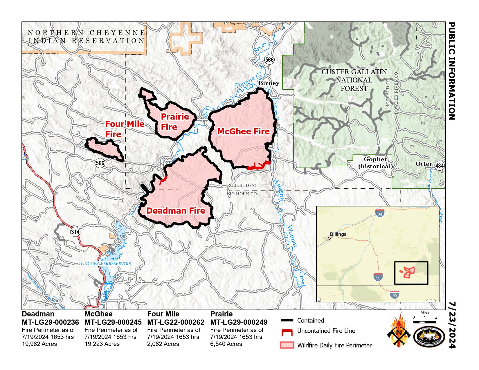
Deadman, McGhee, Prairie, and Four Mile Fires
Bureau of Land Management Montana-Dakotas State Office
Mark Jacobson 406-233-2831
Montana Department of Natural Resources and Conservation
Eastern Land Office Anna Lau 406-247-4400
Fire Information 406-924-3831 (until 9 pm today)
https://inciweb.wildfire.gov/incident-information/mtmts-deadman-fire www.facebook.com/RosebudCountyDisasterAndEmergencyServices
Tuesday, July 23, 2024
Northern Rockies Team 3, Incident Commander Mike Behrens
Location: South of Birney, Montana and north of Tongue River Reservoir in Rosebud and Big Horn Counties
Start Date: 7/12 and 7/13/2024
Cause: Lightning
Size: Deadman: 19,982 McGhee: 19,223 Prairie: 6,540 Four Mile: 2,082
Completion/Containment: Deadman: 95% McGhee: 73% Prairie: 100% Four Mile: 100%
KEY MESSAGE
This is the final update for the Deadman, McGhee, Prairie and Four Mile Fires.
Today is the last day the Deadman Fire(s) will be managed under Mike Behrens’ Northern Rockies Complex Incident Management Team 3. Command will be transferred to a local Type 4 team at 6 a.m. on Wednesday, July 24, with the Bureau of Land Management and Montana Department of Natural Resources and Conservation fire managers. Yesterday, firefighters patrolled and mopped up uncontrolled edges of the McGhee and Deadman Fires, increasing containment percentages for both. Repair of suppression and control lines occurred on all four fires. Extra resources were demobilized or sent to other priority incidents.
CURRENT STATUS
Patrolling, monitoring, and mopping up will continue today. Repair and rehabilitation of suppression and control lines are also ongoing. Hand crews will finish repairing control lines on steep ground today. Unburned islands in the interior of the McGhee and Deadman Fires will continue to burn out in the foreseeable future and produce visible smoke. However, the probability of escape is very low. The temporary flight restriction (TFR) over the fire area will be lifted at the end of today.
WEATHER AND FIRE BEHAVIOR
Temperatures are expected to reach a high of 97° F and 15 percent relative humidity. Winds will generally be from the north with gusts to 8 mph. Triple digit temperatures and very low levels of relative humidity are forecasted for Wednesday and Thursday.
SMOKE
Smoke from Canada and other regional fires is impacting the area. For the current smoke reports, visit www.fire.airnow.gov/
CLOSURES AND SPECIAL MESSAGES
Stage 1 fire restrictions are in place in Bighorn County. Visit www.mtfireinfo.org for current Montana fire restrictions information.
Speirs Fire Daily Update 07 23 2024
Related Incident: Speirs Fire
Publication Type: News
The current weather forecast calls for continued warm and dry conditions over the fire area. This will continue to dry out fuels and make them more available to burn. A weather system is expected to bring moisture to the region on Thursday. This system may be proceeded by dry lightning and erratic outflow winds. Firefighters are strengthening containment lines in anticipation of a possible wind test for the fire area.
Fire crews carried out a low intensity firing operation yesterday along the Speirs Fire's northern perimeter and will continue today. This operation is intended to eliminate pockets of unburned fuels along the perimeter and create a more consistent and manageable containment line.
Hand crews are working diligently on the eastern end of the fire. The progress here has been slower than in other sections of the fire due to very steep terrain and a significant amount of dead and down fuels. Containment along the fire's southern flank has been extended from the western end down to Helispot 5 near the most southerly point of the fire area. Mop-up has been carried out to a depth of 30 feet in from the edge along the perimeter, and crews continue to work through the area, deepening and strengthening the containment line.
Today, an Uncrewed Aerial System (UAS) team arrived on the fire. They have begun flying over the north area of the fire to search for any concealed heat sources outside the containment lines. The UAS will map this area using infrared sensors and then proceed into the area south of the fire footprint where heat from earlier spot fires may have lain undiscovered.
Closures:
The Forest Service has approved an updated evacuation plan for the Firefighters Memorial Campground and Greendale Group Campsite, which will be implemented in the event of a flare-up of the Speirs Fire. With this plan in place, Forest officials are comfortable reopening the Firefighters Memorial Campground and Greendale Group Campsite. Campers will be allowed to reenter these campgrounds beginning today at 10:00 AM.
Being on or within the following campgrounds, roads, and trails are prohibited on the Flaming Gorge Ranger District on the Ashley National Forest: Forest Service Road (FSR) 610, FSR 689, Lowline trail FST103, its junction with the Pipe Creek Trail, FST 003. Forest Service Trail 003 from the beginning at the junction with FST 103 to the junction of Forest Service Trail 004 and Forest Service Trail 004 to Greens Draw Road 049. For more information on existing closures, please visit the Ashely National Forest website at https://www.fs.usda.gov/alerts/ashley/alerts-notices
Temporary Flight Restrictions (TFR): A TFR is in effect over the Speirs Fire area. Using uncrewed aerial systems (UAS)/drones is illegal within the TFR.
Start date: July 13, 2024
Location: Approximately three miles south of the town of Dutch John, Utah and south of Flaming Gorge Reservoir.
Fire size: 715 acres (decrease in acres due to more accurate mapping)
Containment: 48%
Total personnel: 431
Cause: Naturally-Caused, Lightning
Speirs Fire Information Number: 435-709-8209 (6:00 AM to 10:00 PM.)
*There is a decrease in acres from 764 to 715, due to more accurate mapping and the closure for the campground/group sites will be rescinded at 10:00 AM this morning. The official order and updated map will be shared at 10:00 AM, as well.
Shelly Fire Morning Update 07 23 2024
Related Incident: Shelly Fire
Publication Type: News
Location: Siskiyou County, CA Start Date:Wednesday July 3, 2024 at 1:27 PM Size:15,477 acres Percent Contained:55%
Cause:Under Investigation Personnel:2,085
CURRENT SITUATION:
The fire’s footprint is expected to stay largely the same this morning into the night. Areas around Kidder Creek and Patterson Creek may continue to smolder in isolated pockets, but these pose little threat to control lines.
Shelly Fire operations is reducing the number of personnel and equipment while continuing to focus on suppression repair.
Drivers in the area should remain alert for fire personnel and heavy equipment on or near the roadways.
WEATHER:
Today will be the hottest day of the week, bringing moisture in the afternoon, along with a chance of thunderstorms.
EVACUATIONS:
For current evacuation status, visit www.facebook.com/SiskiyouCountySheriff and www.facebook.com/SiskiyouCountyOES. Additional evacuation information and a map can be found on the Genasys site at https://protect.genasys.com/search?z=14&latlon=41.550694%2C-122.905589.
CLOSURES:
An official forest closure around the Shelly Fire went into effect on July 4th. Hikers are not permitted and will be asked to leave the area. For details and a map of the closure area, please visit https://www.fs.usda.gov/Internet/FSE_DOCUMENTS/fseprd1187463.pdf.
FIRE RESTRICTIONS:
Forest fire restrictions are currently in effect. Campfires and stove fires are restricted to those developed areas listed in the forest order at https://www.fs.usda.gov/alerts/klamath/alerts-notices/?aid=88596. Smoking, welding, and operating an internal combustion engine also have restrictions in place.
Pacific Crest Trail Information: https://www.pcta.org/discover-the-trail/closures
Boneyard Fire Evening Update 07 22 2024
Related Incident: Boneyard Fire
Publication Type: News
Boneyard Fire grows while some flanks hold, spot fires outside of Monument start but are caught
MONUMENT, Ore. – The Boneyard Fire was active throughout the day on Monday July 22, growing along southwest flanks in Cupper Canyon and starting spot fires outside of Monument. Firefighters were able to suppress and stop the majority of the spot fires and are likely to stop the remaining spot fires this evening.
Control lines along the northwestern flank of the fire are continuing to hold and the fire did not cross the North Fork John Day River west of Monument along highway 402. The fire is continuing to spread northeast into the Umatilla National Forest, away from structures.
Silver King Fire Daily Update July 23 2024 07 23 2024
Related Incident: Silver King Fire
Publication Type: News
Public Information Phone: (435) 310-5450 Email: 2024.silverking@firenet.gov
Agency: Fishlake National Forest – Beaver Ranger District
Location: Approximately three miles west of Marysvale, Utah
Start Date: July 05, 2024
Cause: Lightning
Acres: 18,189
Containment/Completion: 83%
Personnel: 252
With Pioneer Day approaching tomorrow, all staff assigned to the Silver King Fire wish the people of Utah a safe and enjoyable holiday! We encourage the public to drive safely to and from home. For those planning on recreating outdoors, please consider having the Mountaineers Ten Essentials:
- Navigation
- Headlamp/flashlight
- Sun Protection
- First Aid
- Knife
- Matches/lighter
- Shelter
- Extra food
- Extra water
- Extra clothes
Please exercise extra caution around the fire area, watching for fire equipment and personnel and observing the Forest Closure Order still in effect. Details of the closure can be found at: https://www.fs.usda.gov/alerts/fishlake/alerts-notices. Remember to abide by the Stage 1 Fire Restrictions and avoid activities that could potentially cause another fire.
Firefighters continue to make progress containing the Silver King Fire, focusing on securing containment and removing hazard trees in the Deer Creek drainage on the fire’s northeast corner. Crews also continue to repair and rehabilitate dozer lines on the eastern side of the fire. Firefighters will perform strategic burnout operations on the southern edge of the fire to mitigate risk and contain the fire’s edge against natural barriers.
Tuesday will bring slightly drier and warmer weather with relative humidity likely fall to 15% to 20% and temperatures in the upper 70s to mid-80s. This will result in minimal fire behavior and limited fire spread. There is a slight chance of scattered showers and thunderstorms producing rain on Wednesday with a greater chance on Thursday. These bring gusty winds and potential for flash flooding in and out of the fire area. Smoke impact will remain minimal; for more information go to https://www.wildlandfiresmoke.net/outlooks.
Battle Mountain Complex 07 23 2024
Related Incident: Battle Mountain Complex
Publication Type: News
Firefighters holding strong amid challenging weather
UKIAH, Ore. – Morning operations were challenged by thick smoke and limited visibility, which changed abruptly in the afternoon when the inversion layer lifted and brought high temperatures and wind gusts. That combination increased fire behavior, testing lines and producing several multi-acre spot fires.
On the Snake Fire, firefighters caught a fire that spotted across Camas Creek and Highway 395. Helicopters slowed the fires rate of spread quickly enough for hand crews to line the fire.
Crews were able to hold the southeast corner of the Snake Fire and construct contingency lines. They tied in and improved the dozer line to the south completely across to the Monkey Creek Fire. They also scouted to the north of both fires for a location to construct a similar dozer line to box in the fires. Within the river corridor, firefighters focused on structure protection and creating defensible space around homes.
In other portions of the fire, crews constructed and improved dozer and handlines as directly and safely as possible. Officials expect additional resources in the coming days to bolster capacity.
On the 3,887-acre North Fork Owens Fire, crews continued mop-up operations, bringing containment up to 20% (the complex stands at 3% containment). Crews will continue mop-up operations and patrolling the perimeter.
Firefighters still face critical fire weather in the region and heavy smoke is making it difficult for helicopters to access some portions of the fire. In addition to the smoke from this complex, the area is inundated with smoke from fires across the region.
Closures: A road closure remains in effect for Highway 395, between mile posts 50 through 90, beginning 35 miles South of Pilot Rock.
Evacuations: Level 1 (Be Ready), Level 2 (Be Set) and Level 3 (Go Now) evacuations are in effect. For updated information, visit:
- For Umatilla County, follow facebook.com/UmatillaCountySheriff or sign up for Umatilla County Emergency Alert System at https://member.everbridge.net/index/2590041373147145.
- For Grant County, visit the RAPTOR arcgis site or sign up for alerts at: https://member.everbridge.net/index/825462649520134.
Evening Update 07 23 2024
Related Incident: Durkee Fire
Publication Type: News
Status Update: Durkee Fire was last calculated to be 223,872 acres as of 2:00 pm today (July 22, 2024). Due to the wind, temperatures and dry fuels, the Durkee Fire has been very active again today.
There have also been approximately 6 new fire starts from today’s lightning strikes, predominantly east of the fire and east of I-84. Size range is between 1,000-5,000 acres. We are supporting Rangeland Fire Protection Associations and local resources to respond. Today’s brief rain had minimal impact on fire activity.
The Durkee Fire is actively burning to the east. Tonight, firefighters are planning to complete strategic burn operations from Huntington Road to Lockette to 1-84. This aims to help get ahead of where to fire is moving and protect infrastructure and communities.
Last night firefighters used a burn out operation to protect the Bridgeport area which is holding
Pincer Two fire Update 07 23 2024
Related Incident: Pincer Two Fire
Publication Type: News
Pincer Two Fire Update
9:00 PM, July 22, 2024
Estimated size: 60 acres
Start Date/Time: July 17, 2024
Area of Origin: 21 air miles northeast of Darrington WA
Cause: Lightening
Fuels/Topography: timber, rugged terrain
Structures Damaged: None, there are no homes threatened at this time.
*At this time, the same information email and information phone number will be used for both the Miners Complex fires and the Pincer Two Fire.
Closures:
Campgrounds and Roads: Cascade River Road at and including Marble Creek Campground, Mineral Park Campground, and all tributary roads, trailheads, and trails.
Full closure orders available at: https://www.fs.usda.gov/mbs
Evacuations: None, there are no homes threatened at this time.
Update: The Pincer Two Fire is currently burning in the Mount Baker District and now the North Cascades National Park in the Stephen Mather Wilderness. Fire behavior is moderate backing and flanking with the fire expected to reach the Cascade River Road in the next 5-7 days. The incoming weather is anticipated to be cooler over the next few days.
This morning, crews were able to fly over the fire. Unfortunately, crews weren’t able to see much do to the amount of clouds in the area. An order has been placed requesting hand crews, fallers, and heavy equipment. This will aid in preparing along the Cascade River Road. Tomorrow, Tuesday, July 23, 2024, an engine crew will begin opening up the 1590 road. We have also scheduled an Infer Red (IR) flight to gather more intel on the fire including more accurate acreage.
Smoke: In Washington, communities closest to active wildfires will continue to observe the greatest smoke impacts. The current Air Quality Alert for Chelan County and Methow Valley remains in place. Air quality will likely be unhealthy on the Colville Reservation due to smoke from the Swawilla and Bridge Creek Fires. Increasing winds from the west starting this evening will clear out lingering haze in the rest of the state. Please continue to recreate responsibly and heed all burn bans.. For more information on smoke and air quality please visit: https://wasmoke.blogspot.com/
Air Space Restrictions: There are no air space restrictions at this time.
Campfire Restrictions: The Mt. Baker-Snoqualmie will be elevating to a full campfire ban, even in developed campgrounds, starting Wednesday July 24, 2024 to help prevent human-caused starts in this critically dry period. Additional details at: www.fs.usda.gov/mbs
###
Diamond Complex Level 2 and 3 evacuation levels updated 07 23 2024
Related Incident:
Publication Type: Announcement
The Douglas County Sheriff's Office has implemented the following evacuation levels. Updated information and an interactive map are at www.dcso.com/evacuations. As of July 22 at 8:37pm, the Sheriff's Office modified the evacuation level boundaries for the Lemolo Fire, which is part of the Diamond Complex. Largely, the boundaries remain the same. However, the Poole Creek Campground and the Lemolo KOA have been downgraded to a Level 2 - BE SET - notice. This change is reflects the current public safety needs of the incident.
LEMOLO FIRE AREA
𝐋𝐄𝐕𝐄𝐋 𝟑 - 𝐆𝐎 𝐍𝐎𝐖 - 𝐟𝐨𝐫 𝐭𝐡𝐞 𝐟𝐨𝐥𝐥𝐨𝐰𝐢𝐧𝐠 𝐥𝐨𝐜𝐚𝐭𝐢𝐨𝐧𝐬 𝐚𝐧𝐝 𝐚𝐫𝐞𝐚𝐬:
* 𝐁𝐮𝐧𝐤𝐞𝐫 𝐇𝐢𝐥𝐥 𝐂𝐚𝐦𝐩𝐠𝐫𝐨𝐮𝐧𝐝
* 𝐊𝐞𝐥𝐬𝐚𝐲 𝐕𝐚𝐥𝐥𝐞𝐲 𝐂𝐚𝐦𝐩𝐠𝐫𝐨𝐮𝐧𝐝
* 𝐓𝐡𝐞 𝐍𝐨𝐫𝐭𝐡 𝐔𝐦𝐩𝐪𝐮𝐚 𝐓𝐫𝐚𝐢𝐥 𝐛𝐞𝐭𝐰𝐞𝐞𝐧 𝐔𝐒𝐅𝐒 𝟐𝟔𝟏𝟐 𝐑𝐨𝐚𝐝 𝐚𝐧𝐝 𝐖𝐢𝐧𝐝𝐢𝐠𝐨 𝐏𝐚𝐬𝐬 𝐈𝐧𝐭𝐞𝐫𝐬𝐞𝐜𝐭𝐢𝐨𝐧, 𝐰𝐞𝐬𝐭 𝐭𝐨 𝐭𝐡𝐞 𝐍𝐨𝐫𝐭𝐡 𝐔𝐦𝐩𝐪𝐮𝐚 𝐓𝐫𝐚𝐢𝐥 𝐰𝐡𝐞𝐫𝐞 𝐢𝐭 𝐢𝐧𝐭𝐞𝐫𝐬𝐞𝐜𝐭𝐬 𝐰𝐢𝐭𝐡 𝐭𝐡𝐞 𝐔𝐒𝐅𝐒 𝟐𝟔𝟏𝟐 𝐑𝐨𝐚𝐝.
𝐋𝐄𝐕𝐄𝐋 𝟐 - 𝐁𝐄 𝐒𝐄𝐓 - 𝐟𝐨𝐫 𝐭𝐡𝐞 𝐟𝐨𝐥𝐥𝐨𝐰𝐢𝐧𝐠 𝐥𝐨𝐜𝐚𝐭𝐢𝐨𝐧𝐬 𝐚𝐧𝐝 𝐚𝐫𝐞𝐚𝐬:
* 𝐄𝐚𝐬𝐭 𝐋𝐞𝐦𝐨𝐥𝐨 𝐂𝐚𝐦𝐩𝐠𝐫𝐨𝐮𝐧𝐝
* 𝐔𝐒𝐅𝐒 𝟐𝟔𝟏𝟒 𝐑𝐨𝐚𝐝 𝐬𝐨𝐮𝐭𝐡 𝐨𝐟 𝐈𝐧𝐥𝐞𝐭 𝐂𝐚𝐦𝐩𝐠𝐫𝐨𝐮𝐧𝐝. 𝐓𝐡𝐢𝐬 𝐢𝐧𝐜𝐥𝐮𝐝𝐞𝐬 𝐭𝐡𝐞 𝐊𝐞𝐥𝐬𝐚𝐲 𝐕𝐚𝐥𝐥𝐞𝐲, 𝐏𝐮𝐦𝐢𝐜𝐞 𝐅𝐥𝐚𝐭 𝐚𝐧𝐝 𝐄𝐥𝐛𝐨𝐰 𝐁𝐮𝐭𝐭𝐞 𝐚𝐫𝐞𝐚𝐬.
* 𝐋𝐞𝐦𝐨𝐥𝐨 𝐊𝐎𝐀 𝐂𝐚𝐦𝐩𝐫𝐠𝐫𝐨𝐮𝐧𝐝
* 𝐏𝐨𝐨𝐥𝐞 𝐂𝐫𝐞𝐞𝐤 𝐂𝐚𝐦𝐩𝐠𝐫𝐨𝐮𝐧𝐝/𝐁𝐨𝐚𝐭 𝐑𝐚𝐦𝐩
PINE BENCH FIRE AREA
𝐋𝐄𝐕𝐄𝐋 𝟐 - 𝐁𝐄 𝐒𝐄𝐓 - for all homes in the Slide Creek area downstream to the Soda Springs area. This in inclusive of all addresses between these two points.
TRAIL FIRE AREA
𝐋𝐄𝐕𝐄𝐋 𝟑 - 𝐆𝐎 𝐍𝐎𝐖! - 𝐟𝐨𝐫 𝐭𝐡𝐞 𝐟𝐨𝐥𝐥𝐨𝐰𝐢𝐧𝐠 𝐥𝐨𝐜𝐚𝐭𝐢𝐨𝐧𝐬 𝐚𝐧𝐝 𝐚𝐫𝐞𝐚𝐬:
𝟏. 𝐏𝐚𝐜𝐢𝐟𝐢𝐜 𝐂𝐫𝐞𝐬𝐭 𝐓𝐫𝐚𝐢𝐥 𝐢𝐬 𝐜𝐥𝐨𝐬𝐞𝐝 𝐟𝐫𝐨𝐦 𝐭𝐡𝐞 𝐈𝐧𝐭𝐞𝐫𝐬𝐞𝐜𝐭𝐢𝐨𝐧 𝐨𝐟 𝐇𝐢𝐠𝐡𝐰𝐚𝐲 𝟏𝟑𝟖 𝐄𝐚𝐬𝐭 𝐚𝐭 𝐭𝐡𝐞 “𝐍𝐨𝐫𝐭𝐡 𝐂𝐫𝐚𝐭𝐞𝐫 𝐓𝐫𝐚𝐢𝐥𝐡𝐞𝐚𝐝” (𝐬𝐨𝐮𝐭𝐡𝐞𝐫𝐧 𝐜𝐥𝐨𝐬𝐮𝐫𝐞 𝐩𝐨𝐢𝐧𝐭) 𝐭𝐨 𝐭𝐡𝐞 𝐢𝐧𝐭𝐞𝐫𝐬𝐞𝐜𝐭𝐢𝐨𝐧 𝐰𝐢𝐭𝐡 𝐭𝐡𝐞 𝐔𝐒𝐅𝐒 𝐌𝐚𝐢𝐝𝐮 𝐋𝐚𝐤𝐞 𝐓𝐫𝐚𝐢𝐥 #𝟏𝟒𝟒𝟔 (𝐧𝐨𝐫𝐭𝐡𝐞𝐫𝐧 𝐜𝐥𝐨𝐬𝐮𝐫𝐞 𝐩𝐨𝐢𝐧𝐭) 𝐧𝐞𝐚𝐫 𝐌𝐢𝐥𝐥𝐞𝐫 𝐋𝐚𝐤𝐞.
𝟐. 𝐔𝐒𝐅𝐒 𝐍𝐨𝐫𝐭𝐡 𝐂𝐫𝐚𝐭𝐞𝐫 𝐓𝐫𝐚𝐢𝐥 #𝟏𝟒𝟏𝟎
𝟑. 𝐔𝐒𝐅𝐒 𝐒𝐮𝐦𝐦𝐢𝐭 𝐑𝐨𝐜𝐤 / 𝐂𝐫𝐚𝐭𝐞𝐫 𝐓𝐫𝐚𝐢𝐥 #𝟏𝟒𝟓𝟕
𝟒. 𝐔𝐒𝐅𝐒 𝐌𝐭. 𝐓𝐡𝐢𝐞𝐥𝐬𝐞𝐧 𝐓𝐫𝐚𝐢𝐥 #𝟏𝟒𝟓𝟔
𝟓. 𝐔𝐒𝐅𝐒 𝐒𝐩𝐫𝐮𝐜𝐞 𝐑𝐢𝐝𝐠𝐞 𝐓𝐫𝐚𝐢𝐥 #𝟏𝟒𝟓𝟖
𝟔. 𝐔𝐒𝐅𝐒 𝐇𝐨𝐰𝐥𝐨𝐜𝐤 𝐌𝐨𝐮𝐧𝐭𝐚𝐢𝐧 𝐓𝐫𝐚𝐢𝐥 #𝟏𝟒𝟒𝟖
𝟕. 𝐔𝐒𝐅𝐒 𝐓𝐡𝐢𝐞𝐥𝐬𝐞𝐧 𝐂𝐫𝐞𝐞𝐤 𝐓𝐫𝐚𝐢𝐥 #𝟏𝟒𝟒𝟗
𝐋𝐄𝐕𝐄𝐋 𝟐 - 𝐁𝐄 𝐒𝐄𝐓 - 𝐟𝐨𝐫 𝐭𝐡𝐞 𝐟𝐨𝐥𝐥𝐨𝐰𝐢𝐧𝐠 𝐥𝐨𝐜𝐚𝐭𝐢𝐨𝐧𝐬 𝐚𝐧𝐝 𝐚𝐫𝐞𝐚𝐬:
𝟏. 𝐃𝐢𝐚𝐦𝐨𝐧𝐝 𝐋𝐚𝐤𝐞 𝐇𝐨𝐫𝐬𝐞 𝐂𝐨𝐫𝐫𝐚𝐥𝐬
𝟐. 𝐃𝐢𝐚𝐦𝐨𝐧𝐝 𝐋𝐚𝐤𝐞 𝐂𝐚𝐦𝐩𝐠𝐫𝐨𝐮𝐧𝐝 (𝐞𝐚𝐬𝐭 𝐬𝐢𝐝𝐞 𝐨𝐟 𝐭𝐡𝐞 𝐥𝐚𝐤𝐞) -𝐀𝐋𝐋 𝟐𝟑𝟖 𝐬𝐢𝐭𝐞𝐬, 𝐀𝐋𝐋 𝐋𝐨𝐨𝐩𝐬: 𝐀, 𝐁, 𝐂, 𝐃, 𝐄, 𝐆, 𝐇, 𝐊, 𝐋, & 𝐌
𝟑. 𝐃𝐢𝐚𝐦𝐨𝐧𝐝 𝐋𝐚𝐤𝐞 𝐑𝐕 𝐏𝐚𝐫𝐤- 𝐀𝐋𝐋 𝟏𝟏𝟎 𝐬𝐢𝐭𝐞𝐬
𝐍𝐎𝐓 𝐀𝐅𝐅𝐄𝐂𝐓𝐄𝐃 𝐀𝐓 𝐓𝐇𝐈𝐒 𝐓𝐈𝐌𝐄: 𝐓𝐡𝐢𝐞𝐥𝐬𝐞𝐧 𝐕𝐢𝐞𝐰 𝐂𝐚𝐦𝐩𝐠𝐫𝐨𝐮𝐧𝐝, 𝐁𝐫𝐨𝐤𝐞𝐧 𝐀𝐫𝐫𝐨𝐰 𝐂𝐚𝐦𝐩𝐠𝐫𝐨𝐮𝐧𝐝, 𝐒𝐨𝐮𝐭𝐡 𝐒𝐡𝐨𝐫𝐞 𝐏𝐢𝐜𝐧𝐢𝐜 𝐀𝐫𝐞𝐚, 𝐃𝐢𝐚𝐦𝐨𝐧𝐝 𝐋𝐚𝐤𝐞 𝐑𝐞𝐬𝐨𝐫𝐭, 𝐨𝐫 𝐭𝐡𝐞 𝐫𝐞𝐬𝐢𝐝𝐞𝐧𝐭𝐢𝐚𝐥 𝐜𝐚𝐛𝐢𝐧𝐬 𝐨𝐧 𝐭𝐡𝐞 𝐰𝐞𝐬𝐭 𝐬𝐢𝐝𝐞 𝐨𝐟 𝐃𝐢𝐚𝐦𝐨𝐧𝐝 𝐋𝐚𝐤𝐞.