
See TripCheckcom for Road Updates 07 22 2024
Related Incident: Durkee Fire
Publication Type: Announcement
Road closures/re-openings are very dynamic given how active the Durkee Fire is. Please see to TripCheck.com for the most up-to-date information.
Update Blacklining Begins 07 22 2024
Related Incident: Mestenas Canyon Fire
Publication Type: News
Crews continue to work the Mestenas Canyon Fire, which is slowly growing within completed and planned containment lines. The fire is currently estimated at 584 acres with 15% containment.
On Sunday, crew members black lined along the northern segment of Forest Road 312N. Black lining is burning fuels along a control line ahead of the approaching fire. Meanwhile, crews dug handline and used natural features to gain containment on portions of the southern and eastern edges of the fire.
Fire behavior has been minimal, and significant rain fell in the area early Sunday evening.
There are no evacuations, but oil and gas infrastructure, archeological sites, dispersed camping areas and inholdings may be threatened if the fire grows beyond planned control lines.
The lightning-caused Mestenas Canyon Fire was first reported July 11. It is in the canyon of the same name, about 14 miles southwest of Dulce, N.M., and two miles north of Highway 64, where smoke may cause limited visibility to drivers.
The public can keep updated on the fire by visiting InciWeb or calling a public information officer at 505-216-6793.
Firing operations commence in the northwest portion of the incident 07 22 2024
Related Incident: Speirs Fire
Publication Type: Announcement
Firefighting resources have completed a 'test fire' to ensure they are within in the proper conditions to initiate firing operations. For the rest of the afternoon, smoke will be visible over the incident as crews clean up down and dead material and strengthen the containment lines on the northern edge of the fire. This will prevent the fire from moving toward the dam and communities near Flaming Gorge.
Fire officials ask that the public or communities to not report the smoke as a new wildfire. If you have questions, please do not hesitate to contact the fire information line at (435) 709-8206.
.jpg?VersionId=7Des61X7_oZXUlHFXU9ojCTUulU4K49x)
Homestead Complex Fire Update07 22 2024
Related Incident:
Publication Type: News
Great Basin Team 5 assumes command of Homestead Complex
Great Basin Complex Incident Management Team 5 assumed command of the fires in the Homestead Complex at 6 a.m. today. The fires that make up the Homestead Complex were started by lightning on July 16 when a series of storms moved through the area. The total estimated acreage for all of the fires combined is about 1,000 acres. There are 160 people assigned to the complex with more firefighting resources expected to arrive in the coming days.
Most of the fires are in steep, rugged, inaccessible terrain. Team 5 is dividing the complex into a West Division and an East Division. This will allow for better command and control of firefighting operations.
The named fires in the West Division include the Lost Bucket, No Man, and Steelhead fires. The Lost Bucket Fire is near Francis Creek about 3 miles north of Chilcoot Mountain. Firefighters with the Douglas Forest Protective Association (DFPA) have built a line around the Lost Bucket Fire, but it will need to be reinforced and mopped up before the fire can be declared contained. The No Man Fire is north of Chilcoot Mountain near No Man Creek, while the Steelhead Fire is northeast of Chilcoot Mountain. Both fires are currently unstaffed, but Team 5 Operations personnel are exploring opportunities to engage the fires.
The fires in the East Division include the Horse Heaven, Reynolds Butte and Fuller Lake fires. The Horse Heaven Fire is burning near the end of Forest Road 100 to the east of Horse Heaven Creek. It is staffed with five engine crews, one Type 2 hand crew, a feller buncher and a masticator. The Reynolds Butte Fire is burning on the northwest slope of Reynolds Butte. The fire is staffed with a Type 1 hotshot crew, a Type 2 hand crew, and four engine crews. The Fuller Lake Fire is burning in the area of Bulldog Creek and the Fuller Shelter Forest Camp. It is currently unstaffed and is being assessed for possible operations when additional resources become available.
Weather today is expected to be cooler, with cloud cover in the morning. Light winds are forecast. The combination of cool temperatures, light winds, and higher humidity will create favorable conditions for firefighters. Fire activity is expected to be low.
Area fire restrictions and danger ratings are as follows: Fire Danger Rating: High. Industrial Fire Restrictions: 2. Public Use Fire Restrictions: 2.
CLOSURES: The Umpqua National Forest issued a Forest Closure order on July 20, 2024, in response to fire activity to protect public and wildland firefighter safety. This closure impacts all of the Cottage Grove Ranger District and parts of the Diamond Lake, North Umpqua, and Tiller ranger districts. The closure includes the Boulder Flat Campground and Boat Launch. To view the order, visit www.fs.usda.gov/umpqua.
Actualizacin del incendio Easy 22 de julio de 2024 07 22 2024
Related Incident: Easy Fire
Publication Type: News
Actualización del incendio Easy
22 de julio de 2024
Datos clave
Tamaño: 345 acres Fecha de inicio: 17 de julio de 2024 Ubicación: 17 millas al Oeste de Mazama, WA
Contención: 0% Personal asignado: Causa: Rayos
Recursos asignados: 1 equipo, 3 helicópteros, 5 camiones de bomberos
SITUACIÓN ACTUAL: El incendio Easy está ardiendo en un bosque denso con terreno muy escarpado. El fuego está retrocediendo y se mueve con desplazos cortos cuesta arriba. Está quemando árboles individuales y se detectan fuegos salpicados de corto alcance. Las laderas empinadas con madera contribuyen a una extinción difícil. El incendio Easy es un incendio de extinción completa y los bomberos están usando estrategias y tácticas con la mayor probabilidad de éxito al mismo tiempo que mitigan los riesgos para los bomberos y el público.
El incendio easy se extiende sobre Mt. Hardy, y amenaza el sendero Pacific Crest Trail, mientras que se desplaza cuesta abajo hacia la carretera estatal 20 (SR 20) North Cascades Highway.
La carretera estatal 20 está cerrada en ambas direcciones entre Granite Creek (MP 148) y Easy Pass Trailhead (MP 157). Las cuadrillas en tierra están removiendo árboles muertos entre el borde del incendio activo y la carretera 20 para ayudar a que no se propague el fuego en esa dirección. Este trabajo, junto con la acitividad fuerte del fuego, exige un cierre para proteger al público de peligros como la caída de árboles o rocas junto con el crecimiento del fuego.
El domingo por la mañana, los helicópteros ayudaron a los bomberoscon vertiendo cubetas de agua para frenar la propagación del incendio Easy. Las condiciones calientes, secas e inestable causaron un fuego muy activo y columnas de humo visibles del incendio Easy por la tarde y la noche.
ACTIVIDADES DE HOY: El terreno extremo está impidiendo el ataque directo. Por eso los bomberos están identificando y estableciendo cortafuegos indirectos que toman en cuenta las barreras naturales, como los conductos de avalanchas. Los bomberos continuarán removiendo árboles viejos por encima y en paralelo a la carretera 20 y continuarán estableciendo un acceso seguro a los lado derecho e izquierdo del incendio Easy. Las cuadrillas están estableciendo cortafuegos e instalando sistemas de rociadores.
CLIMA: Las condiciones meteorológicas críticas están contribuyendo a una fuerte actividad del fuego. El Servicio Meteorológico Nacional ha emitido una advertencia de calor excesivo hasta el lunes a las 8 pm. El día de hoy existe una advertencia de bandera roja por causa de las condiciones cálidas, secas e inestables. Las temperaturas se mantendrán entre los 90 y los 100 grados, y se espera que bajen a principios de la próxima semana.
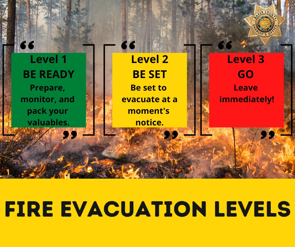
EVACUACIONES: No hay evacuaciones vigentes para el incendio Easy. Cualquier persona que se recree en el área debe estar al tanto de sus alrededores y mantenerse alejado de las áreas cerradas. Visite https://t.ly/QoH9w para aprender sobre los niveles de evacuación.
CIERRE DE BOSQUES: El Bosque Nacional Okanogan-Wenatchee ha tiene cierres en efecto para los senderos dentro del área del incendio: https://bit.ly/EasyFireClosures. Se prohíben las fogatas. Hay una Restricción temporal de vuelo (TFR, por sus siglas en inglés) sobre el incendio: https://tfr.faa.gov/save_pages/detail_4_6779.html. Está prohibida la actividad no autorizada con drones bajo el TFR.
InciWeb: https://inciweb.wildfire.gov/incident-information/waowf-easy-fire
Facebook: https://www.facebook.com/profile.php?id=61560760893080
Línea de información de incendios: 541-861-5808, 8 AM to 8 PM
Correo electrónico: 2024.pioneer@firenet.gov
Malheur County Evacuation Levels Update 1149 am 07 22 2024
Related Incident: Durkee Fire
Publication Type: Announcement
Current evacuation levels for the Durkee fire.
All areas will remain the same with one area added for level 1 or “READY”. The new level 1 area is east of I84 to Highway 201.
Areas of fire activity remain on the south end of the burn so current evacuation levels will remain in place.
Thunderstorm activity and high winds are expected this afternoon.
Actualizacin del incendio Pioneer 22 de julio de 2024 07 22 2024
Related Incident:
Publication Type: News
Actualización del incendio Pioneer
22 de julio de 2024
Tamaño: 30,352 acres Fecha de inicio: 8 de junio de 2024 Ubicación: 31 millas al NO de Chelan, WA
Contención: 14% Personal: 776 Causa: De orígen humano, a ser determinado
Recursos asignados: 11 equipos, 4 helicópteros, 25 camiones de bomberos, 28 tanques de agua, 18 maquinarias pesadas
El martes a las 5pm habrá una reunión comunitaria sobre la situación de Stehekin en el Centro de Visitantes Golden West. También habrá una reunión comunitario sobre Manson el miércoles a las 5:30 p.m. en la preparatoria de Manson. La reunión en Manson será transmitida en vivo en la página de Facebook page. del incendio Pioneer. Envíe sus preguntas con antelación a 2024.pioneer@firenet.gov o a través de Facebook Messenger.
SITUACIÓN ACTUAL: Hoy llegará ayuda de los bomberos y el equipo de la Asistencia estatal de bomberos a Stehekin. Estarán implementando planes de protección de estructuras y prepararán aún más las estructuras e infraestructuras para mejorar su resistencia al fuego. Sigue avanzando el fuego hacia Flick Creek en la ladera norte y ha estado activo en los desagues de Fish Creek y Prince Creek en el extremo Este del incendio. Hoy, debido a las temperaturas, la humedad y los vientos racheados previstos, se espera que crecerá el incendio. En el extremo sur del incendio, los bomberos siguen vigilando la actividad del fuego en el desague de Lone Fir, donde no ha habido mucho movimiento en los últimos días.
ACTIVIDADES DE HOY: Se han completado las líneas de contingencia entre el incendio y Manson a lo largo de Coyote Ridge y Nelson Ridge y se han instalado mangueras. Hoy, se seguirá probando las mangueras y las mejoras en las líneas. Ya casi termina el trabajo a lo largo de Cooper Ridge para prepararlo como cortafuego indirecto. Un grupo de botes está trasladando bomberos y equipos a áreas aisladas a lo largo del lago. Un módulo de fuego con un UAS (dron) está trabajando a lo largo del extremo norte del incendio para detectar focos de calor a lo largo del borde y completar el trabajo de quema estratégica mientras que sea necesario para proteger las cabinas y la infraestructura. Los helicópteros continuarán apoyando los esfuerzos de extinción.
CLIMA: Esta tarde se espera que un frente frío que se aproxima cambie los vientos al oeste-noroeste. Hoy se puso en efecto una Advertencia de bandera roja por causa de las ráfagas de 25 millas por hora que se esperan y la humedad que bajará a alrededor del 25%. Se espera una actividad de fuego, tal como la quema y posibles fuegos en la coronas de los arboles, debido a la situación climática crítica. Se pueden ver algunas columnas de humo.
EVACUACIONES: Los niveles de evacuación de nivel 1, 2 y 3 permanecen vigentes alrededor del incendio Pioneer. Visite https://t.ly/QoH9w para ver más información.
CIERRE DE BOSQUES: Se pueden ver cierres actuales para el Parque Nacional de los North Cascades en: https://www.nps.gov/noca/index.htm. El Bosque Nacional Okanogan-Wenatchee tiene una orden de cierre en efecto para gran parte de la zona del incendio: https://bit.ly/PioneerClosure. Se proíben las fogatas. Hay una Restricción temporal de vuelo (TFR, por sus siglas en inglés) sobre el incendio: https://tfr.faa.gov/save_pages/detail_4_6779.html. Está prohibida la actividad no autorizada con drones bajo el TFR.
InciWeb: https://inciweb.wildfire.gov/incident-information/wases-pioneer
Facebook: https://www.facebook.com/profile.php?id=61560760893080
Línea de información de incendios: 541-861-5808, 8 AM to 8 PM
Correo electrónico: 2024.pioneer@firenet.gov
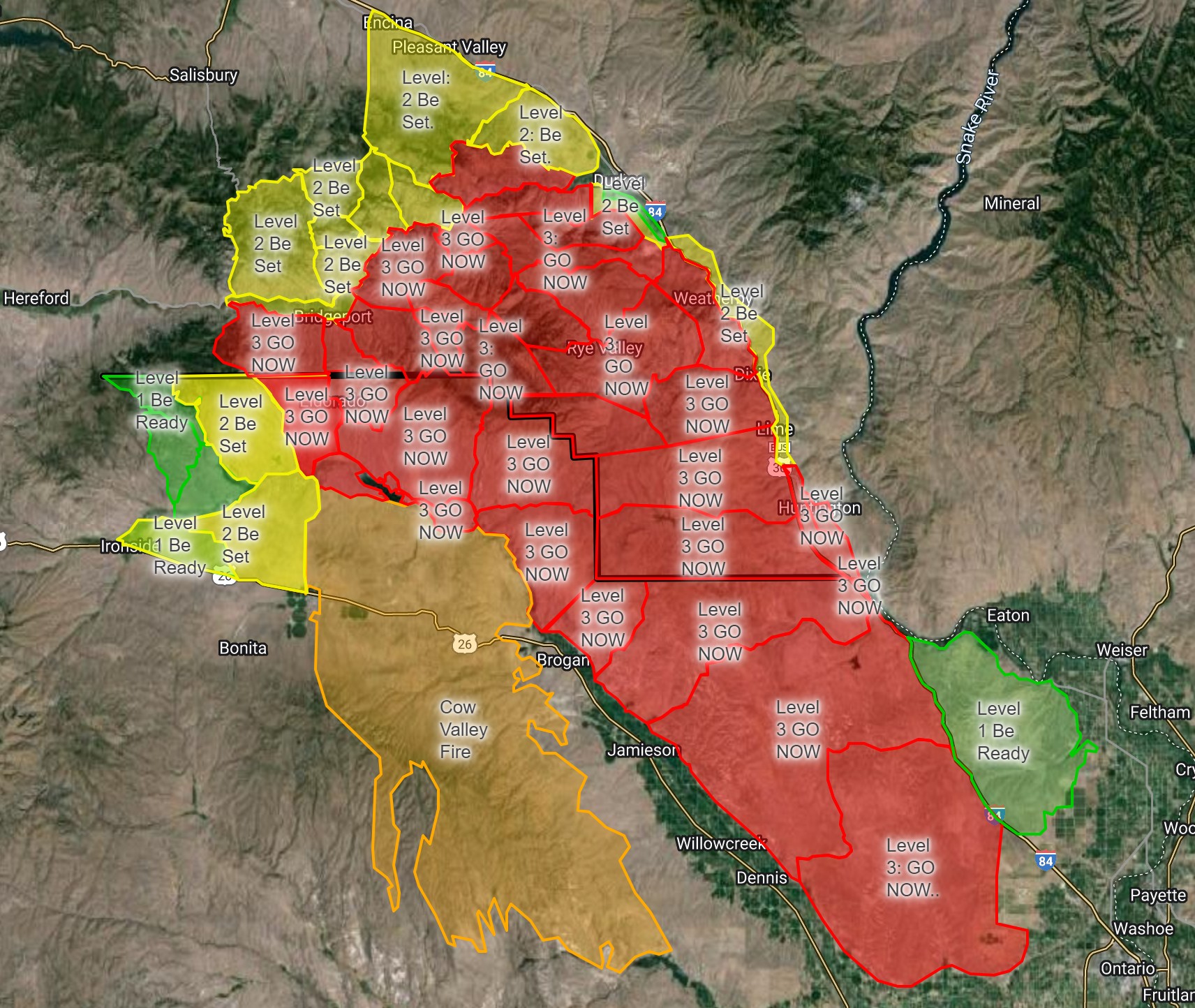
Baker County Evacuation Levels Update 1211 pm 07 22 2024
Related Incident: Durkee Fire
Publication Type: Announcement
Durkee Fire Baker County Evacuation Level Update (7/22/24 12:11 P.M.)
Level 3 (GO NOW) evacuation levels remain in effect for Huntington and the Rye Valley area.
With thunderstorms forecasted late this afternoon, the potential for high winds and unpredictable fire weather, we anticipate the evacuation levels will remain unchanged throughout the day.
Fire officials will continue to evaluate conditions on the Durkee Fire as the day progresses.
Butler Creek Fire Daily Update 07 22 2024
Related Incident:
Publication Type: News
Location: 7 miles northwest of downtown Missoula
Start Date: 7/22/2024
Cause: Unknown
Size: 220 acres
Containment: 0%
CURRENT STATUS
Last night, at 1:30 AM, Missoula Rural Fire Department was first on scene at the Butler Creek Fire, followed by the Montana Department of Natural Resources and Conservation (DNRC). Together they initiated unified command and called for mutual aid. The fire is burning west of Butler Creek Rd in grass and heavy timber. Additional resources have been ordered and a local Type 3 team assumed command at 8:00 AM. Firefighters are working to clear vegetation to create fuel breaks and reduce fire spread. Dozer line is also being created. Three helicopters are dropping water buckets on the fire to cool the fire’s edge and reduce spread.
WEATHER AND FIRE BEHAVIOR
Today, a persistent hot and dry weather pattern will remain over the fire area with temperatures ranging from 95-97 degrees with low humidity. Expect wind speeds of 5-10 mph with gusts up to 19 mph coming from the southeast.
EVACUATIONS AND CLOSURES
The Missoula County Sheriff’s Department has issued an evacuation order for residents on Lavelle Creek Road and on the west side of Butler Creek Road from Lavelle Creek Road to Timberline Ridge. Residents north of Timberline Ridge and on the east side of Butler Creek Road are under and evacuation warning.
***Residents under an evacuation order may return to their homes between 12:00 and 1:00 PM today to gather needed items.
The evacuation order issued for residents in the Indreland and Buffalo Speedway area has been downgraded to an evacuation warning. This includes all of Buffalo Speedway and Indreland Lane east of Buffalo Speedway, and streets accessed off Buffalo Speedway such as Kit Lane, Karamu Lane, Patinella Court and Brow Tine Drive. Please visit the Missoula County Sheriff’s Office Facebook page. To view a map of the EVACUATION ZONES, please visit missoula.co/evacuationmap.
The American Red Cross of Montana has opened an Evacuation shelter at the Christ the King Catholic Church, 1400 Gerald Ave, Missoula. Red Cross services are free and available to all impacted. If you need Red Cross assistance call 800-RED-CROSS. Residents in the surrounding area who have not evacuated should remain vigilant
Diamond Complex Daily Update07 22 0024
Related Incident:
Publication Type: News
Widespread lightning over the Pacific Northwest on July 16 ignited many wildland fires. Fires on the Diamond Lake District of the Umpqua National Forest are grouped into the Diamond Complex.
Currently there are twelve fires totaling an estimated 2,816 acres in the Diamond Complex, with 236 personnel assigned. Firefighters are directly attacking the fires’ edge where access and firefighter safety allow, and implementing indirect strategies using constructed control lines, and utilizing natural barriers where access issues and safety concerns prevent direct attack.
The fires currently comprising the Diamond Complex are Pine Bench, 1,107 acres and 0% contained, north of Hwy 138 near Dry Creek; Trail, 744 acres and 5% contained, east of Hwy 138 on the west slope of Mt. Thielsen; Lemolo, 373 acres and 0% contained, north of Lemolo Lake on Bunker Hill; Pig Iron, 27 acres and 25% contained, Pig Iron Mountain north of Hwy 138; Watson, 77 acres and 0% contained, north of Hwy 138 on Watson Ridge, Brodie, 67 acres and 0 % contained, about 5 miles south of Hwy 138 and south of Devils Canyon; Trep, 58 acres and 0% contained, about 4 miles south of Hwy 138; Garwood, 5 acres and 65% contained, about 3 miles southwest of Mt. Bailey; Slide, 0.1 acres and 90% contained, northeast of Pine Bench; Potter, 242 acres and 0% contained, north of Hwy 138 about 2 miles southeast of Potter Mt.; Ooya, 95 acres and 0% contained, north of Hwy 138 about 1 mile northeast of Bird Point; and Clearwater, 3 acres and 90% contained, south of Hwy 138 about 5 miles northwest of Diamond Lake.
Yesterday, Northwest Team 7 continued active suppression on the Trail Fire. Dozer lines were reinforced with water delivery hose lines from Hwy 138 to the Mt. Thielsen Wilderness boundary. Firefighters continued active suppression on the Pig Iron fire and made good progress to protect critical infrastructure. Firefighters worked to keep the Pine Bench fire west of Forest Road 4775 and away from critical infrastructure as the fire moves north into the Boulder Creek Wilderness.
Nationally and in the Pacific Northwest, fire activity is putting an extreme demand on firefighting resources. This means that firefighters are prioritized and efficiently utilized to protect values at risk. The highest priority will remain public and firefighter safety and protecting infrastructure and homes. Today, active suppression continues with the Lemolo, Trail, Pig Iron and Pine Bench fires as priorities.
Weather: Today begins a trend toward warmer, drier weather, expected to continue into Wednesday. Extremely dry fuels and rugged, steep terrain add to challenging fire behavior.
Closures and Evacuations: The USFS and the Douglas County Sheriff have implemented public safety measures in response to these fires. Umpqua National Forest has issued a closure order that impacts all the Cottage Grove Ranger District and parts of the Diamond Lake, North Umpqua, and Tiller Ranger Districts. The closure order can be found here: https://bit.ly/3SeYvih. This closure does include Boulder Flat Campground and Boat Launch. Additionally, Diamond Lake, Thielsen View, and Broken Arrow Campgrounds are closed through July 28, 2024, and will be reevaluated closer to that date. The Douglas County Sheriff has issued a Level 3: GO NOW for the Trail Fire and the Lemolo fire. There is a Level 2: BE SET for the Pine Bench. Fire danger is set at High and Public Use Restrictions are set at Level 2. Please see detailed information here: www.dcso.com/EVACUATIONS and www.fs.usda.gov/umpqua.