
Oakridge Lightning Fires 2024 Daily Update Wednesday July 31 07 31 2024
Related Incident: Willamette Complex Fires - South
Publication Type: News
Fire Update – Oakridge Lightning Fires
Chalk, Coffeepot, McKinley, Moss Mountain, Tire Mountain, 208, and 217 Fires
Wednesday, July 31, 2024 – 9:00 a.m.
Rocky Mountain Complex Incident Management Team 1
Dan Dallas, Incident Commander
Information Phone: (541) 208-1742
Email:2024.mossmountain@firenet.gov
Information Staffing Hours: 8 a.m. to 8 p.m.
Special Note: A community meeting will be held tonight at 6:00 p.m. in the auditorium of the Oakridge High School, 47997 W 1st St. Oakridge, OR. Fire managers and local officials will provide the latest updates on fire activity and suppression efforts. Parking at the high school is limited; please plan accordingly.
Current Situation: Fire behavior is anticipated to increase today, and over the next several days, as temperatures rise and humidity decreases. Winds will remain light out of the northwest, though up-slope winds may shift slightly to the north. Abundant dead and down fuel is extremely receptive as lichen continues to be observed igniting and carrying flames.
The total acreage of the seven fires is 7,592 acres with 700 personnel assigned.
Information for each of the seven Oakridge Lightning Fires is provided below. Firefighting activities and suppression actions are described in detail for each double-lettered division on each fire.
Chalk Fire (3,525 acres, 26% contained)
Division AA: Low intensity firing operations continued on the west side of the Chalk Fire yesterday. Crews will secure and mop up in these areas while additional strategic options are being considered on Division AA.
Division KK: Similar to Division AA, crews will mop up and secure line from the burn operation that occurred earlier this week. Additional crews continue to prepare the 1925 Road.
Division TT: Heavy equipment continues to build and strengthen line on the north side of the Chalk Fire moving east, while fire managers scout for additional opportunities in Division TT.
Coffeepot Fire (3,591 acres, 0% contained) and Moss Mountain Fire (246 acres, 0% contained)
Division PP: Spot fires on the south side of the Coffeepot Fire were addressed via bucket drops yesterday. Crews continue low-intensity firing operations as well as scouting for, and addressing, additional spot fires attributed to burning lichen.
Division RR: Line north of the Coffeepot Fire has been constructed in Division RR. Low-intensity firing operations occurred last night to secure line. Crews will be mopping up in this area today.
Division SS: Line is being strengthened through the use of heavy equipment from the southern point of the Moss Mountain Fire to the east to tie in with Division WW. Equipment will now be used to push line west toward Division PP. A contingency group is scouting this division, looking for future strategic operations to hold fire north of privately held land.
Division WW: Crews constructed line from the 2307 Road and connected it to the 23 Road yesterday. Efforts will shift today to prepare line down the 23 Road. Crews continue to scout for secondary line options should they be needed.
Tire Mountain Fire (23 acres, 100%) – Division TT: The Tire Mountain Fire has been contained. Crews remain in place to patrol and address potential spot fires. Activity remains minimal on Tire Mountain Fire.
McKinley Fire (24 acres, 0% contained) – Division AA: Firefighters identified and addressed a small spot fire yesterday. Activity remains minimal on McKinley Fire, where staff will remain in place to patrol and address future spots.
208 Fire (145 acres, 0% contained) – Branch XII: Fire is holding. There has been no recent growth in this area.
217 Fire (38 acres, 100% contained) – Branch XII: The 217 Fire is contained. Crews will continue to patrol.
Weather and Fire Behavior:
Warmer and drier conditions have arrived; northwest winds will remain light with some potential for upslope and up valley wind. Smoke is expected to lift around 2:00 p.m. today. Higher temperatures and lower minimum relative humidity will be much lower beginning today, and for the rest of the week.
Very dry and receptive lichen continues to carry fire and ignite spots in abundant dead and dry fuel across the fires. Fire weakened trees from this and previous fires remain a concern to firefighter safety. As temperatures rise and humidity decreases, fire intensity and activity can be expected to increase over the next several days.
Evacuations:
For evacuation information please visit: https://www.LaneCountyOR.gov/2024wildfires
To sign up for evacuation alerts please visit: https://www.LaneAlerts.org
Closures and Fire Restrictions:
Area, road, trail, and recreation site closures are in place on the Willamette National Forest in the vicinity of many active fires. Temporary road barricades are in place to restrict traffic across the fire areas.
For specific closure information follow this link:
https://www.fs.usda.gov/detail/willamette/alerts-notices/?cid=fseprd552029
Fire restrictions on the Willamette National Forest may be found at this link: https://www.fs.usda.gov/alerts/willamette/alerts-notices/?aid=81487
Temporary Flight Restrictions (TFR) are in place over the Chalk and Moss Fires.
Wildfires are a no-fly zone for unauthorized aircraft, including drones. If you fly, we can’t. For more information, visit http://knowbeforeyoufly.org.
For More Information:
Phone: (541) 208-1742
Email: 2024.mossmountain@firenet.gov
InciWeb: https://inciweb.wildfire.gov/incident-information/orwif-oakridge-lightning-fires-2024
Facebook: https://www.facebook.com/OakridgeLightningFires2024/
Total Fire Personnel: 641
Fire Cause: Lightning
Location: North & South of Oakridge, OR
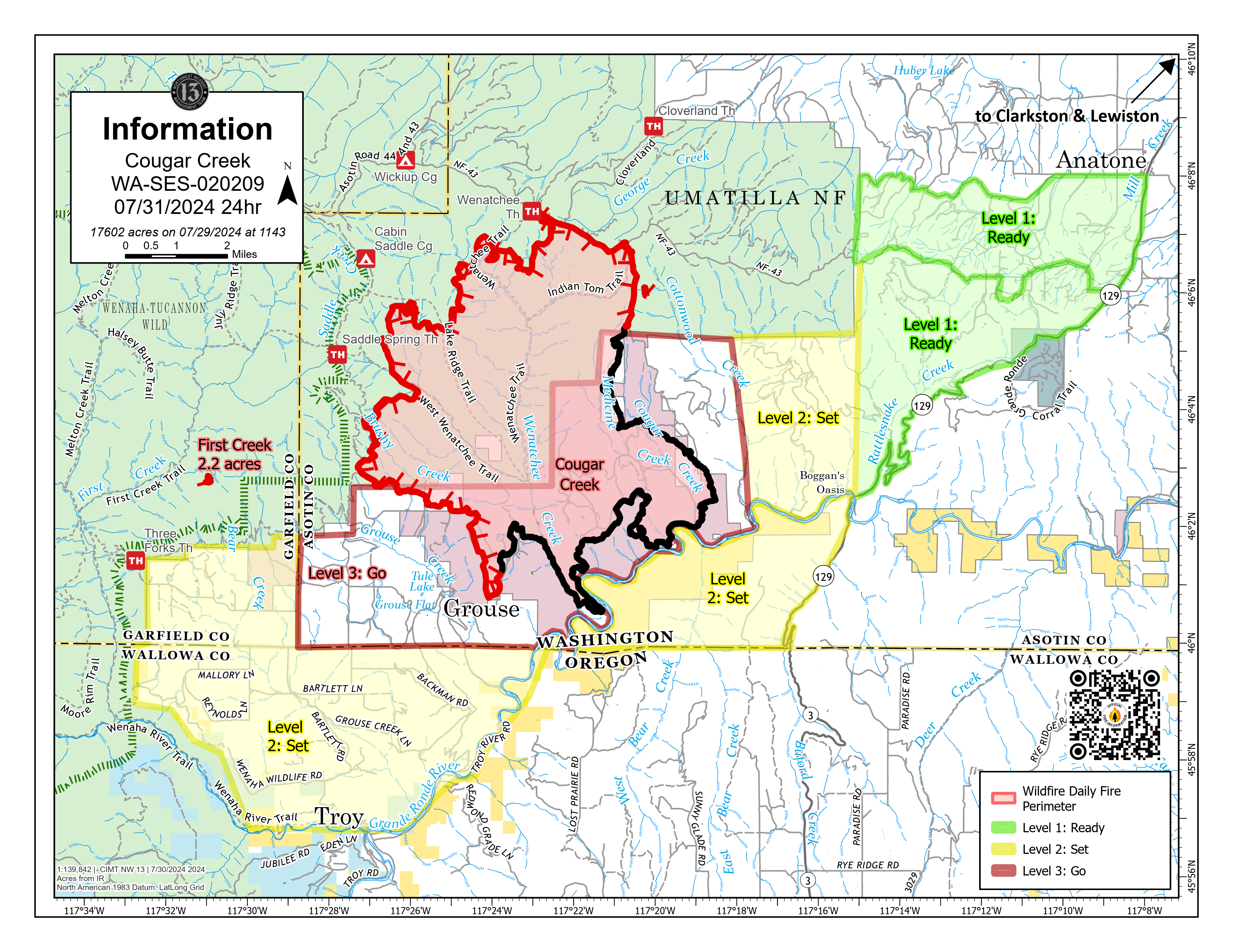
Cougar Creek Fire Update 07 31 2024
Related Incident: Cougar Creek Fire
Publication Type: News
Cougar Creek Fire Update for Wednesday July 31, 2024
KEY MESSAGES:
Recent rains and higher humidity levels slowed fire activity yesterday. Tactical burning operations resumed on the southwest side of the fire yesterday to secure a portion of the perimeter. The secondary line on Mallory Ridge east of the fire is nearing completion.
CURRENT STATUS:
The First Creek Fire, from last week’s lighting storm, continues to be monitored for smoke and is contained. The spot fire on the eastern edge of the Cougar Creek Fire from the strong westerly winds is now controlled and being monitored for hot spots.
On the southwest flank of the fire near Grouse Flats, crews have begun patrolling and monitoring the perimeter. If smoke is detected, Initial Attack (IA) crews will be available for incident response. Tactical firing operations will take place as weather conditions allow on the 600 Road and Hansen Ridge.
Complex Incident Management Team Northwest 13 will transfer command of the Cougar Creek Fire to Complex Incident Management Team Northwest 12, under the direction of Incident Commander Jeff Dimke today at 7:00pm.
FIRE BEHAVIOR AND WEATHER:
Due to lower temperatures and higher relative humidity levels the past few days, recent fire progression has been primarily terrain-driven. Lower humidities are expected today along with atmospheric instability which will release some smoke. A high-pressure system is expected to bring warmer temperatures starting Friday and will lower relative humidity levels leading into the weekend. This rise back into the triple digits later this week, fire behavior may increase.
EVACUATIONS AND CLOSURES:
Forest closure descriptions and maps are available online on the Umatilla National Forest Closure page. In Washington, evacuation notices are posted on the Asotin County Sheriff webpage and Asotin County Emergency Management Facebook page. Grande Ronde Road is closed from Troy, Oregon to Highway 129 junction in Washington. In Oregon, a level 2 evacuation is in effect for Wallowa County, including all of Grouse Flat from Bear Creek Rd north to the State boundary and the Garfield County line to Grande Ronde River.
Media Update 73127 PM Courtrock 07 31 2024
Related Incident: Courtrock Fire
Publication Type: News
Public Meeting in Monument Tonight at 5 P.M.
Firefighters continue to hold and strengthen Courtrock Fire lines
MONUMENT, Ore. – Today on the Courtrock Fire, firefighters will focus on mopping up areas adjacent to the fireline and moving deeper into the fire. As this work continues, they will be looking for larger, heavier fuels that retain heat and could ignite adjacent unburned fuels. Firefighters will use hand tools and water to douse burning material and cool the fire.
Badland Complex Daily Update 07 31 2024
Related Incident: Badland Complex 2024
Publication Type: News
Badland Complex Fire Update
July 31, 2024
Rocky Mountain Area Complex Incident Management Team Two
Jared Hohn, Incident Commander
Highlight: Today, at 4:30 p.m., at the Richland City Hall, Rocky Mountain Area Complex Incident Management Team Two will be on the Richland City Council meeting agenda to present a fire update on the Badland Complex.
Current Situation:
- The Badland Complex is 54,615 acres and 69% contained with 296 personnel assigned. The decrease in acreage is due to an infrared flight, which provided more accurate mapping. Currently there are 75 miles of contained fire line and roughly 30 miles of uncontained line.
- The Thompson Fire is now 31,557 acres and 47% contained. Yesterday, crews gained more containment on the northern edge through a grassy area near Little Lookout Mountain, north of Durkee Creek and Lawrence Creek. Work will continue there for multiple operational periods. On the eastern side, the Gila hotshots and skidgines are working to check and strengthen roughly 12 miles of containment line through thick juniper and timber. With a period of expected high temperatures and possible windy conditions in the future, fire managers are eager to complete work. This work is expected to take multiple operational periods. On the southeastern perimeter, work continues between Lookout Mountain Road and Manning Creek Road.
- The Coyote Fire is now 22,184 acres and 96% contained. The primary focus on this fire is to secure the southern edge of rough country, moving toward the Snake River.
- The Powder, Chalk, Sheep Mountain, Daly, and Crandall Fires are all 100% contained.
- Beginning today, there is a significant weather shift to significantly hotter, dryer weather.
Weather & Smoke Information: Today may see a heavy inversion layer which will bring west/southwest winds on the ridges and up slope, up valley winds gusting up to 15 mph. Skies should be clearer, with less smoke and temperatures in the 90s in the lower elevations and 80s on the hilltops.
An air quality advisory is in effect for Baker County due to heavy concentrations of wildfire smoke. For current Oregon air quality conditions, please visit https://oraqi.deq.state.or.us/home/map.
Evacuations: Multiple areas have been reuced to a Level 2 (BE SET) or are no longer under any evacuations. Learn more at https://www.facebook.com/profile.php?id=100064434892363. Sign up for Baker County emergency alerts at https://public.alertsense.com/SignUp/publicUser.aspx?regionid=1357
Closures: Check for highway closures at https://www.tripcheck.com/DynamicReports/Report/RoadConditions. All BLM Vale District Recreation Sites along the Snake River between Oxbow and Huntington and on Lookout Mountain are closed. This includes Spring Recreation Site, Swedes Landing, and Bassar Diggins Campground.
Fire Restrictions: Fire Restrictions are in effect. Get details at https://www.blm.gov/sites/default/files/docs/2024-07/orwa-fpo-val-071024.pdf.
Temporary Flight Restrictions:A temporary flight restriction (TFR) is in effect over the fire area to provide a safe environment for firefighting aircraft operations. View a map of the TFR and details at https://tfr.faa.gov/save_pages/detail_4_7614.html. Fire aviation response is halted or delayed if an unauthorized aircraft enters the TFR. Temporary flight restrictions also apply to unmanned aircraft systems or drones. If you fly, we can’t! Learn more about how to use drones safely and responsibly at Home - Know Before You Fly.
Fire Info Phone: 541-362-1507 Hours: 7:00 a.m. to 7:00 p.m. Email: 2024.badlandcomplex@firenet.gov .
Facebook: Facebook Badland Complex Fires 2024 Media Line: 541-249-5894
Inciweb: https://inciweb.wildfire.gov/incident-information/orvad-badland-complex-2024
Miller Peak Fire Daily Update July 31 2024 07 31 2024
Related Incident:
Publication Type: News
Key message
The containment of the fire remains at 65% while crews worked in difficult terrain to make sure the fire stays in containment lines. Lower temperatures and precipitation decreased activity of the fire, but some heat remains in heavy fuels such as downed trees and stumps.
CURRENT STATUS
The rightsizing of the crews to fit the needs of the fire continues. The crews out on the line continue work mopping up and securing the spotty eastern flank. Heavy equipment completed the indirect line yesterday that was built to protect I-90 and communities nearby. This indirect line would also serve as a fire break if the fire behavior changes with the incoming weather and to utilize for potential future incidents.
WEATHER AND FIRE BEHAVIOR
A cold front moved through the fire area Monday night which brought around 0.05” of rain on the fire. Steady rain turned into showers on Tuesday afternoon totaling 0.3-0.5” of rainfall throughout the day. A ridge of high pressure is building over the region for the next couple of days causing a warming and drying trend. Yesterday’s precipitation should keep afternoon humidities higher. The winds will become westerly this afternoon with gusts up to 18 mph by mid afternoon.
Closures
Lower Miller Creek Road is closed from debris due to storm damage. A temporary flight restriction is in effect over the fire area. An area and road closure around the fire is in effect due to hazardous conditions resulting from fire activity. Stage II fire restrictions are in effect in the area. Specific closure information and maps are posted on InciWeb at https://inciweb.wildfire.gov/incident-information/mtlnf-miller-peak-fire and https://www.fs.usda.gov/alerts/lolo/alerts-notices as they are implemented.
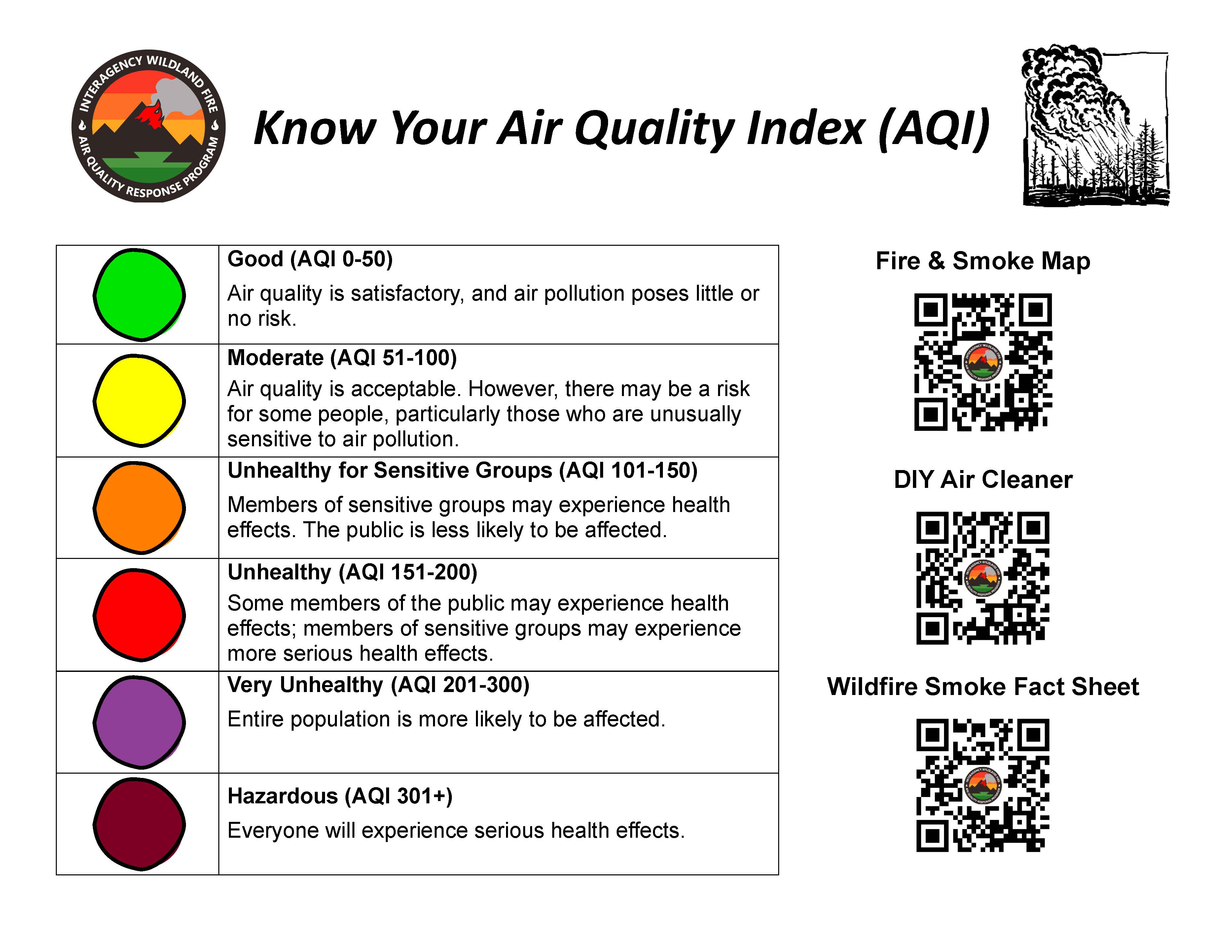
Know Your Air Quality Index AQI 07 31 2024
Related Incident:
Publication Type: Announcement
KNOW YOUR AIR QUALITY
- Fire and Smoke Map
- Do It Yourself (DIY) Air Cleaner to Reduce Wildfire Smoke Indoors (epa.gov)
- Wildfire Smoke Fact Sheet
RELATED RESOURCES
2024 SQF Lightning and Borel Smoke Outlook 07 31 2024
Related Incident: 2024 SQF LightningBorel Fire
Publication Type: News
Fire
Yesterday, interior fuels on the Trout fire consumed near Boone Meadow and SE progression just south of Smith Meadow was minimal but stubbornly persistent. The Borel Fire was active, mostly on the eastern edge, in the south fork of Erskine creek. Expected fire behavior on the Borel includes possible crown fire runs and spotting.
Smoke
Yesterday, smoke transport was again influenced by westerly winds and tracked to the east/northeast. The lower Owens Valley was impacted and evening pooling in Lone Pine occurred, causing periods of USG to UNHEALTHY air quality there. Today, westerly flow will decrease under a ridging pattern, and we’ll see temperatures begin to tick up. Western foothill communities will see generally MODERATE to USG conditions caused by the new Pedro fire. The southern Owens Valley can expect MODERATE to periods of UNHEALTHY conditions around Lone Pine. The north valley should see generally MODERATE conditions. Lake Isabella and Kernville can expect periods of MODERATE to USG in the AM through early afternoon. Conditions in Lake Isabella and Kernville should improve by late afternoon as winds increase.
Speirs Fire Fact Sheet 07 31 2024
Related Incident: Speirs Fire
Publication Type: News
Speirs Fire Fact Sheet
July 31, 2024
Current Status
- The Speirs Fire is currently at 715 acres and is 97 percent contained.
- The Speirs Fire was caused by lightning.
- There are currently 75 people working on the Speirs Fire.
Closures
- The Firefighter Memorial and Green Dale Group campgrounds are open.
- The following roads and trails are still closed to public access.
- Forest Service Road (FSR) 610, FSR 689, FSR049 (Greens Draw Road), Lowline trail FST103 its junction with the Pipe Creek Trail, FST 003. Forest Service Trail 003 from the beginning at the junction with FST 103 to the junction of Forest Service Trail 004 and Forest Service Trail 004 to Greens Draw Road 049.
- For more information on existing closures, please visit the Ashley National Forest website at https://www.fs.usda.gov/alerts/ashley/alerts-notices
Updates
- Smoke may be visible as interior pockets of fuel continue to burn.
Lone Rock Fire Update Wednesday 07 31 2024
Related Incident: Lone Rock Fire
Publication Type: News
LONE ROCK FIRE UPDATE July 31, 2024
Location: Lonerock, Ore. to west of Highway 207 | Size: 137,221 acres | Containment: 80%
Cause: Under Investigation
Start Date: July 13, 2024 | Total Personnel: 447
Fire Information Line: 541-208-4369, 8 a.m. to 8 p.m.
Email: 2024.0404rvlonerock@firenet.gov
Southwest Area Complex Incident Management Team 2 To Command Lone Rock Fire
Condon, Ore. — The Southwest Area Complex Incident Management Team 2 (Team2), led by Incident Commander John Truett, assumed command of the fire at 6:00 this morning. Incident objectives include firefighter and public safety, protecting property, infrastructure, and other values at risk while implementing full-suppression tactics.
Yesterday's Activities: Yesterday, crews continued work mopping up areas retaining heat on the east and west sides of the fire. On the east side, work was completed on the area between Flatiron Spring and FSR 25, and an additional 3 percent containment was added to the map, bringing the total containment to 80 percent. Firefighters remained heavily engaged on the west side of fire working on the slopover fire near Notch RD. Chipping work was completed along HWY 19. The north and south ends of the fire remain in patrol status, with no areas of concern observed.
Today’s Activities: Operational objectives will remain largely the same as they have been over the last several shifts. Crews will continue to mop-up and secure the lines on the east and west sides of the fire perimeter and continue to patrol the remainder of the fire area.
Weather: A ridge of high pressure over the Four Corners region will begin to re-amplify into the Northwest region on Wednesday. Temperatures will warm to near average with highs in the 80s to low 90s. Relative humidity will be on a downward trend bottoming out in the 20s. Winds will remain light, and terrain driven.
Evacuations: There are no Level 3 evacuations in place for the Lone Rock Fire. For up-to-date information, checkout the Real-Time Assessment and Planning Tool for Oregon (RAPTOR) public information map, see link below. Additional information is also available from:
- For Gilliam County evacuation information, visit Gilliam County Sheriff's Office Facebook page.
- For Wheeler County evacuation information, visit Wheeler County Sheriff’s Office Facebook page.
- For Morrow County evacuation information, visit Morrow County Sheriff's Office Facebook page.
Closures:
• For updated road closure information, visit https://www.tripcheck.com/.
- Umatilla National Forest Order Number 06-14-02-24-02 includes prohibitions within the Heppner Ranger District on the Umatilla National Forest.
- Bureau of Land Management (BLM) Prineville District Office issued an Emergency Public Land Closure on BLM-managed lands along the main stem John Day River and along the North Fork John Day River from Kimberly, Ore. to Dale, Ore.
Smoke Information: Visit https://fire.airnow.gov/ for local air quality information.
Flight Restrictions: A Temporary Flight Restriction (TFR) is in place above the Lone Rock Fire area.
###
Crazy Creek Fire Daily Update for July 31 2024 07 31 2024
Related Incident: Crazy Creek
Publication Type: News
Community meetings scheduled for the towns of Post and Prineville this week
Daily Update July 31, 2024
Fire Information Phone:541-208-1768 (8am-8pm)
Media Information Phone:541-208-1770 (8am-8pm)
Email: 2024.crazycreek@firenet.gov
Acres: Crazy Creek - 28,064; 498/Kitty Creek - 73 Start Date: July 22, 2024
Location: Crazy Creek:16 miles north of Paulina, OR Personnel: 395 total for both fires
498/Kitty Creek: 7 miles south of Mitchell, OR
Containment: Crazy Creek 0%; 498/Kitty Creek 86% Fuels: Timber and short grass
Resources: 7 crews | 25 engines | 9 bulldozers | 8 water tenders | 1 masticator | 11 skid steer
Highlights: Southwest Area Incident Management Team 5 is planning to host two community meetings this week, including a community meeting for the town of Post tonight, July 31 at 6 p.m. at the General Store and a community meeting for the town of Prineville tomorrow, August 1 at 6 p.m. at the Crook County High School.
Fire Activity: The 498/Kitty Creek fire is in monitor status. On Tuesday, fire activity intensified in portions of the Crazy Creek fire. Crews responded to several spot fires on the western side of the fire and fire crossed constructed containment lines on the southern tip. Aerial operations, including air tankers and helicopters, responded to spot fires. Firefighters will work hard today to continue these efforts.
Today, crews on the north end of the Crazy Creek fire will continue with tactical firing operations and monitoring containment lines as crews work to secure the area. On the northeast and eastern portion of the fire, crews continue to secure structures in the Toggle Meadows area. On the south end of the Crazy Creek fire, ground crews will utilize direct attack firefighting tactics to limit growth of the spot fires that crossed containment lines yesterday. Air resources, including bucket helicopters and tankers will continue supporting firefighting operations in the area as well, as conditions allow.
Along the southern perimeter, where spot fires occurred yesterday, firefighters will focus additional efforts on structure protection for threatened values at risk, including historic structures and other values within Roba Ranch.
Evacuations: Mandatory evacuation orders remain in effect for areas in Crook and Wheeler Counties for areas in or near the fire. Level 1 “GO” evacuations have extended from the Forest Boundary to highway 380. Level 2 “SET” evacuations have extended south of highway 380.
Weather: The 498/Kitty Creek and Crazy Creek fire area will experience drastically warmer and dryer conditions. Temperatures will increase to the high 80s/low 90s and wind gusts between 15-18mph.
Importance of Fire Prevention: All public lands in Central Oregon, to include the Ochoco National Forest are in Public Use (Fire) Restrictions. All open flames, including woodstoves and charcoal briquette fires are prohibited. In times of high fire danger, it is crucial for everyone to follow fire prevention measures to avoid additional strain on overburdened resources. The public's cooperation in adhering to fire bans and restrictions is vital to prevent new fires from starting and to help our firefighters focus on containing the existing fires. Learn more at https://www.fs.usda.gov/alerts/ochoco/alerts-notices/?aid=89068.
Smoke: Smoke from multiple fires in Central Oregon are impacting the region. Additional details are available via https://outlooks.wildlandfiresmoke.net/outlook/079f0f73.
Fire Restrictions and Closures: The Ochoco National Forest has implemented a forest closure for the Paulina Ranger District. More information can be found at fs.usda.gov/alerts/ochoco/alerts-notices/?aid=89203.
More Information:
InciWeb: https://inciweb.wildfire.gov/incident-information/orocf-crazy-creek
Facebook: https://www.facebook.com/SWIMT5
Central Oregon Wildfire Information: https://centraloregonfire.org/
Crook County Emergency Information Map: https://arcg.is/1ij0vb