
Actualizacin diaria del incendio Microwave Tower 31 de julio de 2024 07 31 2024
Related Incident: Microwave Tower Fire
Publication Type: News
Actualización diaria del incendio Microwave Tower
31 de julio de 2024
Tamaño: 1,311 acres
Fecha de inicio: 22 de julio de 2024
Causa: A ser determinada
Ubicación: 5 millas al oeste de Mosier, OR
Contención: 53%
Combustibles: Arbustos, restos de madera y césped
Aspectos destacados:
El aumento del tamaño del incendio se debe a un mapeo más acertado, pero no ha crecido desde ayer. Existen focos internos de vegetación sin quemar que continúa ardiendo y produciendo humo. Estos focos de vegetación presente no amenazan la línea del cortafuego. Ayer, la intensidad del incendio fue mínima y las líneas se mantienen.
Operaciones:
Ayer, los bomberos continuaron las operaciones de neutralización para seguir asegurando el cortafuegos del noroeste. En otras zonas, los equipos monitorearon el cortafuegos mientras que rocas desplazándose representaron un peligro de seguridad. El agua vertida por los helicópteros respaldó los esfuerzos de extinción a lo largo de la sección empinada al noreste del incendio donde los equipos no pueden acceder a pie. Los equipos controlaron y monitorearon el perímetro restante del incendio. Hoy, continuarán las operaciones de neutralización en el lado noroeste del incendio. Se utilizarán tanques de agua y camiones de bomberos en el extremo noreste del incendio para verter agua en zonas con calor. Los equipos supervisarán el perímetro del incendio y alrededor de estructuras en la zona del incendio. Se usarán equipos aéreos según sea necesario.
Clima e intensidad del incendio:
El flujo de los vientos terrestres es débil; las corrientes serán ligeras y subirán las temperaturas. Los combustibles permanecen secos y los focos internos de combustible sin quemar seguirá produciendo humo y existe posibilidad de ver llamas. Se pide a los conductores que utilicen con precaución la Interestatal 84 mientras los bomberos y equipos aéreos sigan trabajando en la zona.
Evacuaciones:
Los niveles 3, 2 y 1 de evacuación no han cambiado en el condado Wasco: https://www.facebook.com/WascoCountySheriff
Los niveles 2 y 1 de evacuación no han cambiado en el condado Hood River: https://www.facebook.com/hrcso
Caminos y vías cerrados:
Para garantizar la seguridad del público y de los bomberos, existen órdenes de cierre para el sendero Historic Columbia River Highway State Trail y las carreteras en el condado Hood River. Podrá encontrar los detalles de estos cierres en sus páginas web: https://www.hoodrivercounty.gov/closures and https://stateparks.oregon.gov/
Para mantenerse informado sobre las condiciones actualizadas en la Interestatal 84, visite https://tripcheck.com/
Total de recursos asignados al incendio: Aproximadamente: 167 personas, 6 equipos de obreros, 9 camiones de bomberos, 2 buldóceres, 1 tractor y 2 helicópteros.
Información de contacto:
Correo electrónico: 2024.microwavetower@firenet.gov, Teléfono: 541-208-1744, de 8 a.m. a 8 p.m. Escanee el código QR para tener más información
![]()
Actualizacin del incendio Easy 31 de julio de 2024 07 31 2024
Related Incident: Easy Fire
Publication Type: News
Actualización del incendio Easy
31 de julio de 2024
Datos clave
Tamaño: 528 acres*
Fecha de inicio: 17 de julio de 2024
Ubicación: 17 millas al oeste de Mazama, WA
Contención: 0%
Personal asignado: 127
Causa: Rayo
Recursos asignados: 3 cuadrillas 6 camiones de bomberos
*no hay datos infrarrojos actualizados debido a las condiciones climáticas
SITUACIÓN ACTUAL: Ayer hubo una mínima propagación de fuego y la actividad continua dentro del perímetro del incendio. En el extremo norte del incendio Easy, las cuadrillas completaron el trabajo en las zonas de aterrizaje de helicópteros para que se pueda transportar a las cuadrillas y así minimizar los largos tiempos de viaje. Los bomberos también eliminaron los árboles peligrosos y ampliaron los cortafuego indirectos. Continuaron las operaciones de astillado a lo largo de la carretera 20 para remover vegetación de la carretera. Los escombros fueron llevados en camiones fuera del área del incendio hasta del sendero Cedar Creek Trailhead. En el extremo sur del incendio Easy, se probaron los sistemas de rociadores y continuaron trabajando para reforzar los cortafuego indirectos.
Permanece abierto al tráfico la carretera 20 y un vehículo piloto escolta a los vehículos a través de los postes de millas 148-157 de 7 a.m. a 8:30 p.m. todos los días. Espere retrasos de 30 minutos mientras los bomberos continúan removiendo árboles y escombros de la carretera y llevan a cabo el trabajo de extinción completa en el incendio Easy. Por favor, no se detenga entre los postes de millas 148-157. Debido a que los incendios y las operaciones de extinción siguen activos, tal vez tenga que cerrarse la carretera nuevamente con poco aviso. Asegúrese de consultar https://wsdot.com/Travel/Real-time/Map/ para obtener la información más reciente sobre la carretera 20.
ACTIVIDADES DE HOY: Debido al clima cálido y seco que se prevé, se espera que la actividad de los incendios aumente un poco con continuos brotes lentos y ocasionales. Las cuadrillas continuarán eliminando la vegetación y los escombros de árboles de las orillas de la carretera 20 y ampliando los cortafuego indirectos. También implementarán el transporte en helicóptero a las áreas más elevadas del incendio Easy para comenzar a trabajar a lo largo de la línea de la cresta del monte Hardy. Las cuadrillas continúan buscando oportunidades para mejor proteger la cima de la cresta y las líneas indirectas con futuras operaciones de quema estratégica.
Existe una restricción de vuelo temporal por el incendio Easy para todas las aeronaves que no participan en la extinción de los incendios forestales. No vuele un dron personal sobre o cerca del incendio Easy. Cualquier incursión crea un peligro para la seguridad de las aeronaves y requiere que se suspendan las operaciones aéreas.
CLIMA: Hoy continuarán aumentando las temperaturas a medida que comienza una tendencia de calentamiento y sequía a medida que se forma una fuerte cresta en el noroeste. Se esperan nubes dispersas por la mañana y cielo mayormente soleado por la tarde. Los vientos soplarán del noroeste de 1 a 4 y aumentarán a 7 a 10 mph después de las 10:00 a.m.
CIERRES: El Bosque Nacional Okanogan-Wenatchee tiene órdenes de cierre en los senderos dentro del área afectada por el incendio: https://bit.ly/EasyFireClosures. Este cierre incluye una parte del sendero Pacific Crest Trail. Las fogatas están prohibidas. Hay una restricción temporal de vuelo (TFR, en inglés) sobre el área del incendio: https://tfr.faa.gov/save_pages/detail_4_6779.html. La actividad de drones no autorizados está prohibida por la TFR.
EVACUACIONES: No existen órdenes de evacuación para el incendio Easy. Cualquiera que utilice la zona para recrearse debe estar atento a su entorno y permanecer fuera de las áreas cerradas.
InciWeb: https://inciweb.wildfire.gov/incident-information/waowf-easy-fire
Facebook: https://www.facebook.com/profile.php?id=61560760893080
Línea de información sobre el incendio: 541-861-5808, de 8 AM a 8 PM
Correo electrónico: 2024.pioneer@firenet.gov
Community Meeting in Izee 07 31 2024
Related Incident: Falls FireTelephone Fire
Publication Type: Announcement
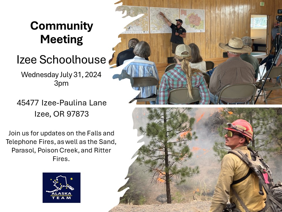
Community Meeting
Izee Schoolhouse
Wednesday July 31, 2024
3pm
45477 Izee Paulina Lane
Izee, OR 97873
Join us for updates on the Falls and Telephone Fires as well as the Sand, Parasol, Poinson Creek, and Ritter Fires.
The meeting will also be shared on the Malheur National Forest Facebook page, as well as the Falls and Telephone Fires Facebook page.
July 31 2024 Homestead Complex Daily Update 07 31 2024
Related Incident:
Publication Type: News
HOMESTEAD COMPLEX FIRE UPDATE
Wednesday, July 31, 2024
Fire Information
Phone: 208-713-9693 (8 a.m. to 8 p.m.)
Email: 2024.homesteadcomplex@firenet.gov
Facebook: www.facebook.com/HomesteadComplexFireInfo
Inciweb: http://inciweb.wildfire.gov/incident-information/orupf-homestead-complex
Smoke Outlook: https://outlooks.airfire.org/outlook/d393fd74
Cooperator Helicopter Assisting with Fire Suppression
Firefighters saw average growth yesterday on the Homestead Complex. The acreage for the seven fires within the complex is 1,892 acres with 5% containment. There are 481 personnel currently working on the fire. Fire managers are directing resources to fires based on threat to property, infrastructure, industry, and areas with the highest probability of success.
After a few days of cooler weather, temperatures will increase today and tomorrow and stay high through the week. With the increase in temperatures and decrease in humidities, fire behavior may increase in some areas. Isolated pockets of previously dried fuels may ignite more readily along southern and western slopes that receive more sun.
On the south side of No Man Fire (699 acres) sawyers are working to fell hazardous and dead standing trees along the recently completed portion of fireline. The stretch of line on Chilcoot Mountain has been completed.
Firefighters finished prepping the road around the Salmon 33 Fire (176 acres). They will begin lining the road with hoses, as well as burn out the sides of the road to create more defensible space. Heavy equipment finished constructing dozer-line from Chilcoot Mountain to the border of the Salmon 33 Fire.
A helicopter on loan from Douglas Forest Protective Association continued to assist firefighters and helped extinguish a spot fire on the Reynolds Butte Fire (244 acres). Hand crews continue to strengthen the line surrounding the fire. Yesterday, an Unmanned Aerial System (UAS) burned out small areas to help widen the fireline.
Today sawyers are clearing hazard trees along the previously constructed fireline on the Horse Heaven Creek Fire (529 acres). Handline on the Bullpup Fire (138 acres) has been completed. Crews are strengthening the handline by clearing brush and removing hazard trees. Crews continue to build fireline around the Fuller Lake Fire (71 acres).
Fire managers declared Lost Bucket Fire (34 acres) 100% contained on Tuesday. Firefighters continue to patrol and monitor the fire.
Current forest fire restrictions and danger ratings are: Fire Danger Rating: Very High. Industrial Fire Precaution Levels (IFPLs): 3. Public Use Fire Restrictions (PURs): 3.
CLOSURES: The Bureau of Land Management (BLM), Roseburg District, has issued a closure order for portions of BLM land which border the Umpqua National Forest Emergency Fire Closure north of Steamboat. The closure order can be viewed here: https://www.blm.gov/sites/default/files/docs/2024-07/orwa-fpo-rbg-072624.pdf. Umpqua National Forest Emergency Fire Closure ORDER NO. 06-15-24-03 and ORDER NO. 06-15-02-24-01 remain in effect and can be found here: https://www.fs.usda.gov/alerts/umpqua/alerts-notices.
Programas de ayuda a los propietarios de viviendas del Departamento de Recursos Naturales DNR de Washington 07 31 2024
Related Incident: Retreat
Publication Type: Announcement
Programas de ayuda a los propietarios de viviendas del Departamento de Recursos Naturales (DNR) de Washington:
Durkee Fire Update for Wednesday July 31 2024 07 31 2024
Related Incident: Durkee Fire
Publication Type: News
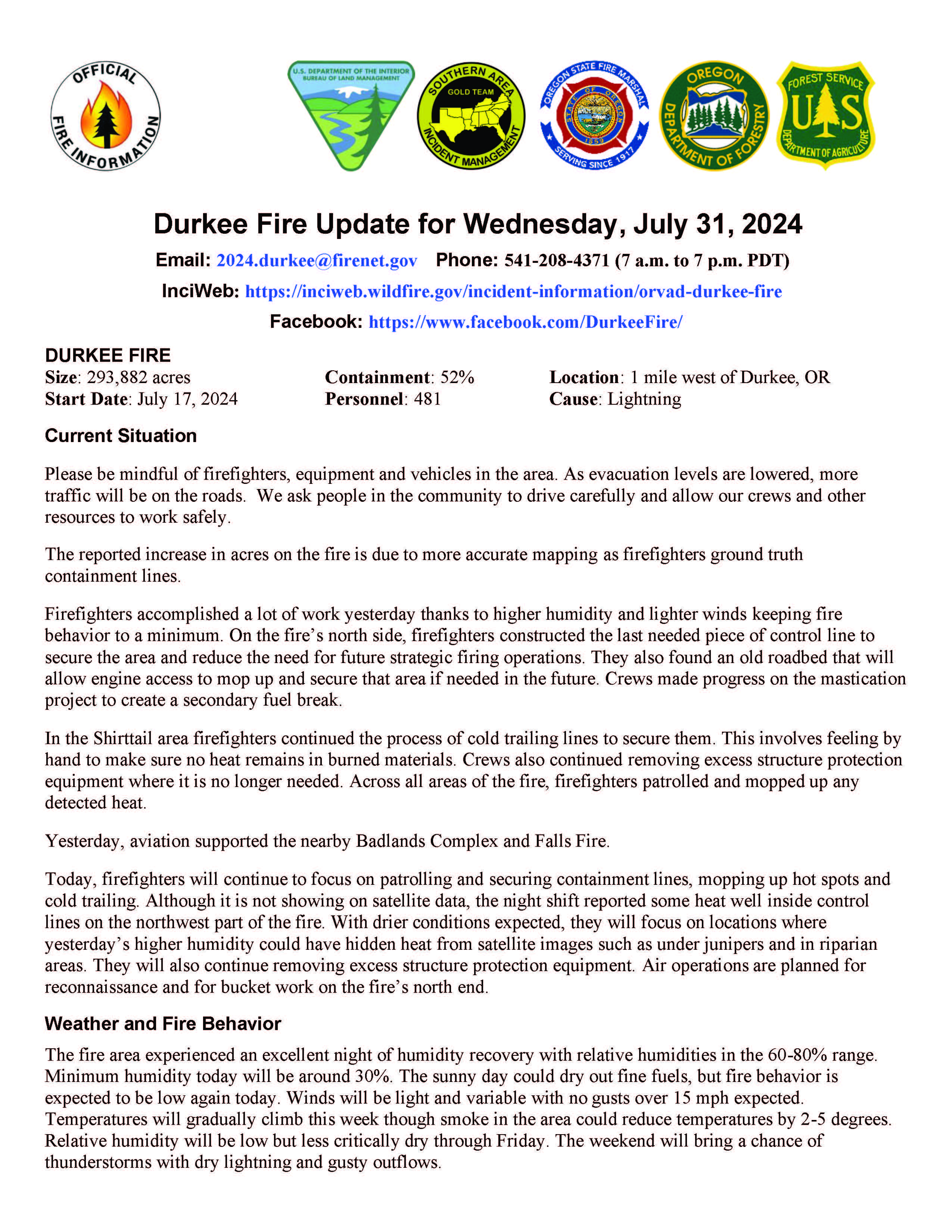
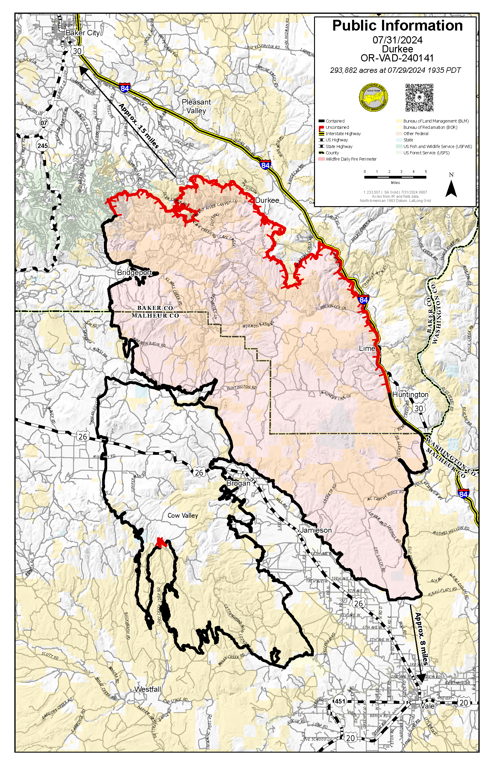
Durkee Fire Update for Wednesday, July 31, 2024
DURKEE FIRE
- Size: 293,882 acres
- Containment: 52%
- Location: 1 mile west of Durkee, OR
- Start Date: July 17, 2024
- Personnel: 481
- Cause: Lightning
Current Situation
Please be mindful of firefighters, equipment and vehicles in the area. As evacuation levels are lowered, more traffic will be on the roads. We ask people in the community to drive carefully and allow our crews and other resources to work safely.
The reported increase in acres on the fire is due to more accurate mapping as firefighters ground truth containment lines.
Firefighters accomplished a lot of work yesterday thanks to higher humidity and lighter winds keeping fire behavior to a minimum. On the fire’s north side, firefighters constructed the last needed piece of control line to secure the area and reduce the need for future strategic firing operations. They also found an old roadbed that will allow engine access to mop up and secure that area if needed in the future. Crews made progress on the mastication project to create a secondary fuel break.
In the Shirttail area firefighters continued the process of cold trailing lines to secure them. This involves feeling by hand to make sure no heat remains in burned materials. Crews also continued removing excess structure protection equipment where it is no longer needed. Across all areas of the fire, firefighters patrolled and mopped up any detected heat.
Yesterday, aviation supported the nearby Badlands Complex and Falls Fire.
Today, firefighters will continue to focus on patrolling and securing containment lines, mopping up hot spots and cold trailing. Although it is not showing on satellite data, the night shift reported some heat well inside control lines on the northwest part of the fire. With drier conditions expected, they will focus on locations where yesterday’s higher humidity could have hidden heat from satellite images such as under junipers and in riparian areas. They will also continue removing excess structure protection equipment. Air operations are planned for reconnaissance and for bucket work on the fire’s north end.
Weather and Fire Behavior
The fire area experienced an excellent night of humidity recovery with relative humidities in the 60-80% range. Minimum humidity today will be around 30%. The sunny day could dry out fine fuels, but fire behavior is expected to be low again today. Winds will be light and variable with no gusts over 15 mph expected. Temperatures will gradually climb this week though smoke in the area could reduce temperatures by 2-5 degrees. Relative humidity will be low but less critically dry through Friday. The weekend will bring a chance of thunderstorms with dry lightning and gusty outflows.
Evacuations
Yesterday, the Baker County Sheriff’s Office changed evacuation levels throughout the county (https://www.facebook.com/profile.php?id=100064434892363). Most notably, evacuation levels for Huntington, portions of Rye Valley and Pleasant Valley have been removed. Multiple areas have been reduced to a Level 2 (BE SET) or are no longer under evacuation levels. They ask the public to continue to be vigilant. Weather patterns and fire activity may lead to an increase in evacuation levels.
The Malheur County Sheriff’s Office (https://www.facebook.com/profile.php?id=100069245917855) and the Baker County Sheriff’s Office (https://www.facebook.com/profile.php?id=100064434892363) have issued evacuation orders for multiple areas during the Durkee Fire. Please stay tuned to their Facebook pages for the latest information.
Residents in Level 3 Evacuations “GO NOW” should leave immediately and not return to their property until evacuation levels are lowered. Carry enough supplies to support you and your family for multiple days. A real-time map of fire evacuations is available on the State of Oregon Fire Dashboard (https://www.arcgis.com/apps/instant/portfolio/index.html?appid=22d04c007866419c91ccf00d097526c8).
Closures:
- The Baker County Sheriff's Office has closed Burnt River Canyon Road to non-local, non-emergency traffic.
- I-84 and other highways: Please go to tripcheck.comfor current road closures as the situation is dynamic and subject to change.
- A burn ban is currently in effect for all of Malheur County (https://www.malheurco.org/category/public-notices), and all Bureau of Land Management lands in Malheur and Baker counties.
- A temporary flight restriction remains in effect over the Durkee Fire. More information is available at https://tfr.faa.gov/save_pages/detail_4_6061.html. Please remember, if you fly we can’t! If a drone or other aircraft enters the air space, all firefighting aircraft will be grounded.
Additional Resources:
- For current air quality information, visit fire.airnow.gov.
- Weather and fire behavior could impact transportation, power transmission, cell service and other utilities. Monitor IdahoPower.com for information.
Diamond Complex and Middle Fork Daily Update 07 31 2024
Related Incident: Middle Fork Fire
Publication Type: News
July 31, 2024
**Diamond Complex and Middle Fork fire Q & A session at Diamond Lake Resort, 12:00 pm, Wednesday July 31, 2024. Fire staff on hand to answer community questions. **
The Diamond Complex on the Umpqua National Forest is estimated at 5,486 acres and 11% contained and Middle Fork within Crater Lake National Park s 728 acres and 1% contained. The park remains open. There are fire personnel in the area, so visitors should use caution when traveling within the park.
The Umpqua National Forest increased Public Use Restrictions to Level 3 across all ranger districts of the forest in response to the drying conditions and increased fire activity. More information can be found at bit.ly/3xIZZdK. Broken Arrow, Diamond Lake, and Thielsen View Campgrounds are open and taking reservations through www.recreation.gov
The Trail fire, east of Hwy 138 on the west slope of Mt. Thielsen, is 839 acres and 40% contained. Yesterday, firefighters strengthened fire lines and patrolled the fire. Firefighting resources from this fire are being reassigned to other critical missions in the Complex.
The Lemolo fire, north of Lemolo Lake on Bunker Hill, is 873 acres and 0% contained. Firefighters conducted strategic burning operations to strengthen containment on the north edge and worked to tie the containment line on the western flank to the Lemolo Lake Road.
The Pine Bench fire, north of Hwy 138 near Dry Creek, is 2,117 acres and 10% contained. Crews continue to hold and mop up along the FS 4775 Road and patrol the 900 Road and Hwy 138. Work is underway to build indirect contingency fire line to the east and north of the fire, to be used if the fire were to move out of the Boulder Creek Wilderness.
The Rough fire, two miles south of Hwy 138, is 11 acres and 10% contained. Firefighters continue direct attack on this fire.
Crews on both the Watson fire, 236 acres and 50% contained, and Loafer fire, 37 acres and 50% contained, will continue to mop up these fires.
Bear Trap, 64 acres and 50% contained, 2 miles south of Hwy 138 near Bear Trap Mountain now has a control line around the entire fire so crews will begin mop up and patrol.
The Pig Iron fire, near Pig Iron Mountain north of Hwy 138, is 27 acres and 95% contained.
Ooya, 190 acres and 10% contained, north of Hwy 138 about 1 mile northeast of Bird Point. Work is underway to establish safe access to begin active work on the fire. There is significant power infrastructure to the south of this fire, making it a high priority as firefighters are reassigned from other fires.
Brodie, 121 acres and 0% contained, about 5 miles south of Hwy 138 and south of Devils Canyon. Teams of fallers and a roadside chipping operation are underway to establish safe and effective access for firefighters.
Other fires within the complex consist of: Trep, 133 acres and 0% contained, about 4 miles south of Hwy 138; Garwood, 5 acres and 95% contained, about 3 miles southwest of Mt. Bailey; Slide, 0.1 acres and 95% contained, northeast of Pine Bench; Potter, 747 acres and 0% contained, north of Hwy 138 about 2 miles southeast of Potter Mountain; ; Clearwater, 0.7 acre and 100% contained, south of Hwy 138 about 5 miles northwest of Diamond Lake; Elephant, 0.7 acres and 95% contained, 2 miles southwest of Lemolo Lake; Lost, 25 acres and 0% contained, 4 miles south of Hwy 138; Sheep, 0.3 acres and 95% contained, 3 miles north of Diamond Lake; Thin, 0.6 acre and 95% contained, four miles northwest of Diamond Lake; Trap, 15 acres and 0% contained, 1 mile south of Hwy 138 near Trap Mountain; Campwood, 20 acres and 10% contained, 2 miles south of Hwy 138; Birds, 0.1 acres and 100% contained; Wood, 23 acres and 10% contained, 2 miles south of Hwy 138, Mowich, 0.4 acre and 95% contained, 1 mile north of Hwy 138, Toolbox, 0.1 acres and 95% contained, and Canal, 1 acre and 50% contained.
The Middle Fork fire is located in the northwest corner of Crater Lake National Park. Firefighters completed line along the western flank and across the southern end of the fire to check potential fire spread. The Pacific Crest Trail from the Dutton Ridge Intersection to Hwy 138, Lightning Springs, Bald Crater Loop, Bert Creek and Boundary Springs Trails (within the park) are closed until further notice due to potentially hazardous conditions.
Weather: High pressure begins to move over Oregon, bringing a ten degree increase in temperature and lower humidity. Temperatures are expected to reach the mid-80s and humidity will be in the 30-35% range. Winds will be from the northwest at 5-8 mph.
Fire Behavior: Fire behavior has been largely limited to surface fire with slow spread. Today will begin a trend toward more active fire behavior with isolated and group torching in response to changing weather.
Smoke Outlook: Smoke production will increase with increased fire behavior. Smoke will remain in the area and may reduce visibility and hinder air operations. For the most up to date information, please visit fire.airnow.gov/
Fire prevention: As the weather warms and dries, the potential for rapid fire growth will increase in this area for the foreseeable future. Please be very careful with any potential ignition sources. Don’t park in dry grass, and make sure tow chains do not drag.
Closures and Evacuations: Umpqua National Forest has issued two closures across the forest in response to fire activity to protect public and wildland firefighter safety. Emergency Fire Closure ORDER NO. 06-15-24-03 and Emergency Fire Closure ORDER NO. 06-15-02-24-01 impact all of the Cottage Grove Ranger District, most of the Diamond Lake Ranger District, and parts of the Tiller and North Umpqua Ranger Districts. The closure orders can be found here: www.fs.usda.gov/alerts/umpqua/alerts-notices. Fire danger is set at Very High and Public Use Restrictions are set at Level 3: bit.ly/3xIZZdK.
The Douglas County Sheriff’s Office has downgraded the evacuation order for the Trail fire from a Level 2: BE SET to a Level 1: Get Ready, but the Level 3: GO NOW remains in effect for the Trail fire east of Hwy 138. The Level 2: BE SET and Level 3: GO NOW evacuations for the Lemolo fire remain in place. There is still a Level 2: BE SET for the Pine Bench Fire. For more information visit the Douglas County Sheriff’s Office website: www.dcso.com/evacuations
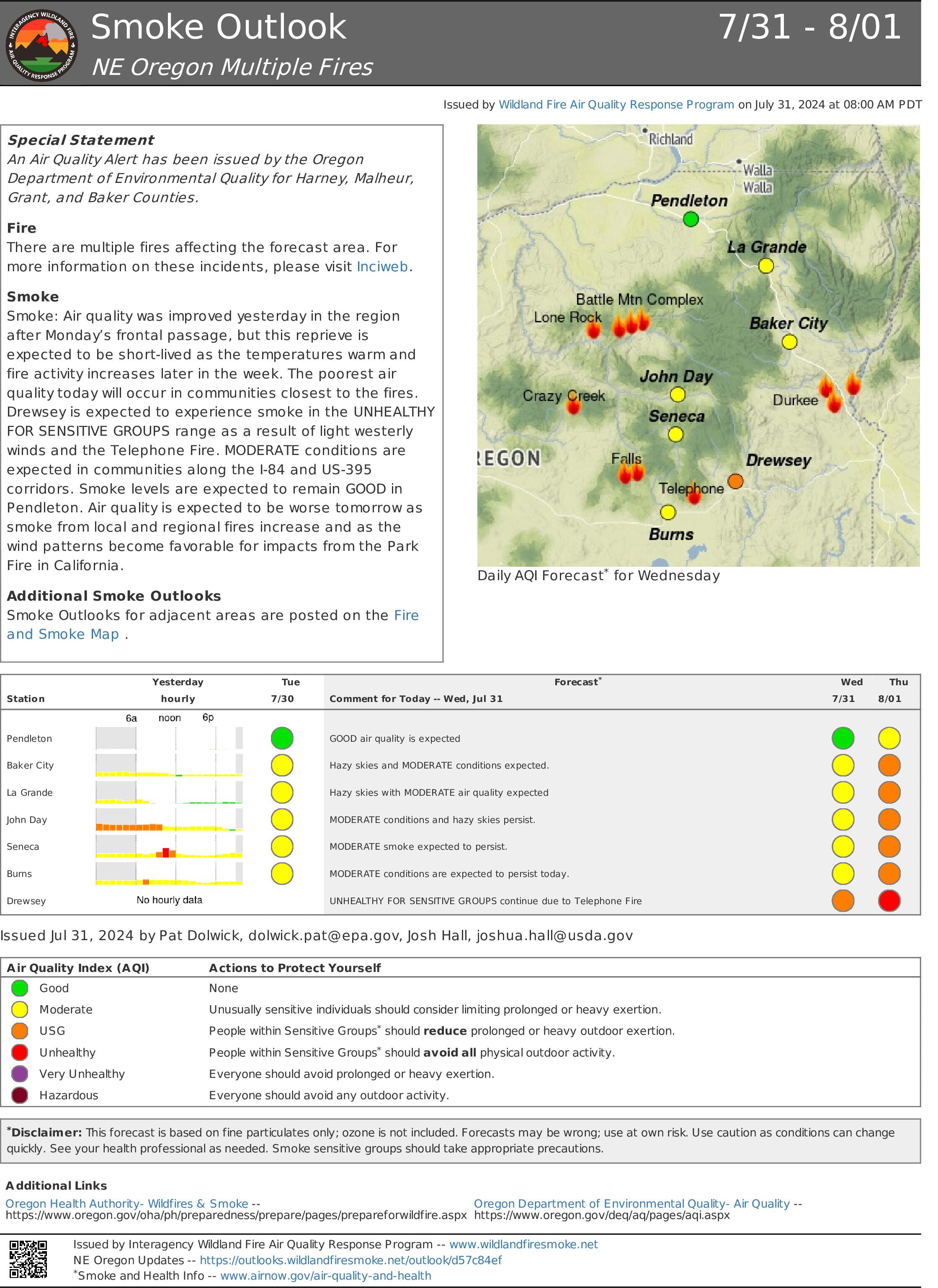
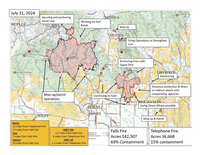
Falls and Telephone Fires Update 07 31 2024
Related Incident: Falls FireTelephone Fire
Publication Type: News
Falls and Telephone Fires Update for July 31, 2024
Telephone Fire Quick Facts:
Size: 36,668 Start Date: July 22, 2024 Location: 12 miles NE of Burns, OR
Containment: 15%. Total Personnel: 364 personnel Cause: Lightning/Natural
Resources Assigned: 9 hand crews, 15 engines, 6 bulldozers, 7 water tenders, 3 skidders
*Resource numbers are changing rapidly as crews are re-allocated to this Fire.
Falls Fire Quick Facts:
Size: 142,307 Start Date: July 10, 2024 Location: 13 Miles NW of Burns, OR
Containment: 69% Total Personnel: 769 Cause: Human-caused, under investigation
Structures Triaged: Residences: 386; Commercial: 119 Outbuildings: 760
Resources Assigned: 34 hand crews, 44 engines, 16 bulldozers, 24 water tenders, 6 masticators, 8 skidders
Sand Mountain Fire Quick Facts:
Size: 4,927 Start Date: July 25, 2024 Location: 17 miles SW of Seneca, OR
Containment: 0% Total Personnel: Staffed by Falls Fire personnel Cause: Lightning/Natural
Ritter Fire Quick Facts:
Size: 459 Start Date: July 23, 2024 Location: Stinking Water Mountain NE of Crane, OR
Containment: 52%. Total Personnel: 41 personnel Cause: Lightning/Natural
Resources Assigned: 1 hand crew, 4 engines, 1 water tender
4 Oregon National Guard hand crews will be arriving to assist with the firefighting effort on these fires (2 crews arrive on July 31st and 2 arrive on August 1st. Learn more at:
Aerial resources available: 3 Type 1 helicopters assigned and available to all fires in the area. 4 Single Engine Airtankers (SEATs) available for initial attack. To date, aerial resources have dropped about ½ million gallons each of water and retardant on these fires. Helicopters drop water and fixed wing planes drop retardant. Air resources can fly 10 flight hours per day. Additional planes come from a pool of resources serving the northwest and go to fires designated with the highest priority in the U.S.
New Fire Activity Quick Facts:
Whiskey Mountain: 4,212 acres; Cow Creek: 86 acres; Parasol: 485 acres; Poison: 593 acres.
Total Personnel: Staffed by Falls Fire personnel.
Community Meetings Scheduled:
Wednesday, July 31 at 3 pm: Izee, OR at the Izee Schoolhouse; 45477 Izee-Pauline Lane; Izee, OR 97873
Leaders of the Alaska Incident Management Team will be in Izee for a community meeting to provide an update on the Telephone Fire, Falls Fire and several other fires we are working to suppress in the area. The meeting will also be shared on the Malheur National Forest Facebook page, as well as the Falls and Telephone Fires Facebook page.
Priorities for Wednesday, July 31: In all areas, crews will continue to improve lines over the next 48 hours to increase their chances of holding through the next weather event.
- Initial Attack: The potential for new fire starts in the area remains significant at this time, and firefighters remain vigilant and focused on initial attack (IA) and are ready to respond to any new threats.
- Along the east side of Telephone Fire, crews will work towards anchoring off of the 2850 road, prepping for small-scale ignition along the road system and dozer line, and working toward the southwest.
- On the southwest side of Telephone Fire, crews will continue to hold and improve existing line.
- Poison Fire: Crews will conduct small-scale firing operations on the northeast corner, working in both directions to continue containment.
Fire Summaries:
Many areas are in mop up/hold/improve status, including the Whiskey Mountain Fire area, the northwest sides of the Sand/Falls fires, and east sides of the Falls, Parasol, and Ritter fires. This is due to crews’ great progress in securing good line which continues to hold in these areas. Mop up is a rigorous process used by wildland firefighters to extinguish or remove burning materials near a fire’s control lines after it has been contained. The goal of mop up is to make the fire safer, reduce smoke, and prevent spread to unburned areas.
Telephone Fire: On Tuesday, Crews began work on ignition operations to prevent any northern progression. Local partners from the BLM and the Rangeland Fire Protection Association (RFPA) assisted in creating line to the south and east of the Upper Pine Fire footprint and are also bringing line down to the 2850 road with dozer lines, prepping for small-scale ignition, to corral the fire in a catcher’s mitt shaped area. This work will continue Wednesday. Some of the acreage increase shown for this fire from yesterday is due to firing operations, which are burning fuels during favorable conditions to keep the fire in the desired area. Crews worked in the Poujade Field area using skidgines, which are a cross between skidders and engines containing large water tanks. This equipment can work in steep or loose terrain that engines and water tenders would not be able to access. The west side of the fire is looking good.
On the north side, there was lots of active fire on Tuesday. A shortage of resources requires managers to pick the most effective operations that can hold. We are flexible with the resources we have, pivoting when needed to send them to the most critical areas. Crews are working 24/7 towards reaching priorities on the Telephone Fire, including more than 290 people working the night shift on the fire. Night shift firefighters work in the highest priority areas and places with imminent effects and concerns, and two interagency hotshot crews, highly specialized firefighters, were added to the Telephone Fire overnight Tuesday.
Falls Fire:
The south end of the continues to look good and is patrol and monitor status. The Coral Springs area is holding some heat, but is doing okay. On Tuesday, crews had success in firing operations on the nearby Whiskey Mountain Fire, and the fire is staying within containment line. A contingency line behind existing line is being constructed. The north portion of the fire in the direction of Izee has not moved in the last 2 days. Wednesday, crews will continue mop up in the Whiskey Mountain Fire area, and continue progress on a fuel break along the 31 road.
Sand Mountain Fire:
Crews worked Tuesday on holding line around Smokey Creek on the northwest side of the fire; work also continued to tie line into the 31 road. The intent is to secure line to protect community of Izee, bringing dozer line around into 31 road to use as indirect line. This process is going smoothly, and crews making good progress with 2.4 miles completed as of Wednesday morning. Crews will continue to work to secure this line on Wednesday. Along the 3145 road, prep work is complete.
Parasol and Poison Fires: The Parasol is completely surrounded with line which crews are continually reinforcing. On the Poison Fire, crews continued small-scale firing operations to hold the fire where it is along the west and south sides of the fire; they will continue this work on Wednesday and are anticipating completion soon.
Ritter Fire: Line is completed around 100% of the fire; crews continue to grid, mop up interior green islands, and hold line. Gridding is an important process done when line is complete where firefighters search for any small fires that could potentially exist inside line, by systematically traveling over an area on parallel courses or gridlines.
Weather: Seasonably cool temperatures prevailed on Tuesday with some afternoon sunshine. Lingering low level moisture led to moderate afternoon humidity values. Today there will be a warming and drying trend, with temperatures increasing by 5 to 10 degrees and relative humidity dropping 5-10%. Light winds this morning will give way to typical afternoon westerly winds.
Evacuations: Due to the continued growth east of the Telephone Fire, evacuations have expanded. For the most accurate evacuation information, please visit the Harney County Sheriff’s evacuation map here: https://tinyurl.com/3zst4sjy, or the Grant County Emergency Management Facebook page at: https://www.facebook.com/profile.php?id=100068819321423.
Closures: Due to active wildfires compounded by extremely unfavorable weather conditions, limited firefighting resources and County Resources, Malheur National Forest officials have temporarily closed lands within the Malheur National Forest.
Investigation: U.S. Forest Service fire investigators are seeking the public’s assistance with any tips or information pertinent to the start of the Falls Fire on the Malheur National Forest. Please submit any information that could assist fire investigation efforts to SM.FS.R6TipHotLine@usda.gov.
Temporary Flight Restriction (TFR): TFRs in the area have been changing; pilots should check the latest information on the Federal Aviation Administration TFR website prior to flying: https://tfr.faa.gov/tfr_map_ims/html/index.html
Facebook: https://www.facebook.com/p/Falls-Fire-2024-61562126623985/
Falls Fire InciWeb: https://inciweb.wildfire.gov/incident-information/ormaf-falls-fire
Telephone Fire InciWeb: https://inciweb.wildfire.gov/incident-information/ormaf-telephone-fire
Fire Information Line: 541-208-4370, staffed 8 a.m. to 8 p.m.
Email: 2024.Falls@firenet.gov
Harney County non-emergency evacuation questions: 541-589-5579
Air quality questions: 541-573-2271. Air quality information, searchable by zip code: www.airnow.gov
Smoke Outlooks: https://outlooks.airfire.org/outlook
Bluff Creek Complex Daily Update 07 31 2024
Related Incident:
Publication Type: News
Bluff Creek Complex
Idaho Panhandle National Forests
Fire Information 208-557-8813
https://inciweb.wildfire.gov/incident-information/idipf-bluff-creek-complex
July 31, 2024
Idaho Panhandle Type 3 Incident Management Team
Incident Commander Brian Hicks and Incident Commander Trainee Bryce Barth
Location: The fires are burning along both sides of the Bluff Divide, approximately 13 1/2 miles southeast of Avery, ID; five and a half miles west from Gold Creek Campground; and approximately two miles northwest of Junction Ridge.
Start Date: 7/25/2024 Cause: Lightning Size: 573 acres
Completion/Containment: 0%
196 Total Personnel:
1 Engine
4 Type 2 Hand Crew
3 Interagency Hotshot Crews
6 Heavy Equipment
1 Water Tender
2 Falling Modules
Key Message:
Between July 29 and July 30, the Bluff Creek Complex received 1-inch of rain, greatly moderating fire activity for the remainder of yesterday. However, due to measurable rain, road access has become limited due to muddy road conditions.
Current Status:
The Bluff Creek Complex consists of four different fires: Junction Fire, East Fork Fire, Dominion Point Fire, and Buffalo Fire. With the amount of precipitation received over the fire yesterday and the day before, there was no measurable growth in the Junction Fire, East Fork Fire, or Dominion Point Fire. Due to the immediate threat to values at risk, including private industry timberlands, active logging sales, and equipment, the Junction Fire and the East Fork Fire remain priority.
The Buffalo Fire is 100% contained at this time. On both the Junction Fire and East Fork Fire, crews were able to construct direct handline along portions of each fire. At this time, both the Junction Fire and East Fork Fire are 40% contained. The Dominion Point Fire was scouted, and crews are still proposing areas to construct both direct and indirect fireline. Today, crews will continue to reinforce areas of the Junction and East Fork Fires with additional hose lays, adding to what has been previously implemented.
WEATHER
Temperatures today will start to track warmer, ranging from 80-88 in the valleys and 71-81 in mountains. Humidity will start to dry out and decrease, ranging from 28%-40% in the valleys and 35%-50% in the mountains. Winds will remain breezy, coming from the southwest, three to eight miles per hour. Today will be sunny, with temperatures increasing into the weekend and relative humidities decreasing.
Closures and Special Messages
Closure orders are in place to protect the safety and welfare of the public and provide for safe firefighting efforts and access. Specific closure information and maps are posted on InciWeb at https://inciweb.wildfire.gov/incident-closures/idipf-bluff-creek-complex and https://www.fs.usda.gov/alerts/ipnf/alerts-notices as they are implemented.
The Bluff Creek Complex closures include the following roads and area:
- CLOSED:
- Order Number: # 01-04-04-24-005 (Bluff Creek Fire Road Closure)
- Forest Development Road 509 beginning at its junction with County Highway 50 and concluding at its intersection with Forest Development Road 201.
- Forest Development Road 1258 beginning at its junction with Forest Development Road 509 concluding at its intersection with Forest Development Road 201.
- Forest Service Development Road 1956F beginning at its junction with Forest Development Road 509 and concluding at its unction with Forest Development Road 3338.
- Forest Development Road 322 beginning at its junction with Forest Development Road 201 concluding at Conrad Peak.
- Order Number: # 01-04-04-24-006 (Gold Flat Area Closure): Gold Flat undeveloped campsite located 8.6 miles North on Forest Development Road 218 from Red Ives Cabin. Gold Flat undeveloped campsite is located within Section 23 and 24 in T16N, R30W. The area Gold Flat undeveloped campsite, where defined on the map, comprises of 6.2 acres bordered by the St. Joe River on the West and Forest Development Road 218 on the East.
- Order Number: # 01-04-04-24-005 (Bluff Creek Fire Road Closure)
At this time, a TEMPORARY FLIGHT RESTRICTION is in place for 27NM SE KELLOGG, Idaho near MULLAN PASS VOR/DME (MLP). No pilots may operate an aircraft in the areas covered, including drone pilots.
###
Wednesdays Daily Ops Video for the Lone Rock Fire Available Now 07 31 2024
Related Incident: Lone Rock Fire
Publication Type: Announcement
Operations Section Chief for Southwest Area Complex Incident Management Team 2, Patrick Moore, provides a daily operations update for Wednesday, July 31, 2024, for the Lone Rock Fire over on our Facebook page (see below for link). Go there now to to get the latest update.