
Pincer Two Fire Daily Update 08 11 2024
Related Incident: Pincer Two Fire
Publication Type: Announcement
11:00 AM, August 11, 2024
Estimated size: 115 acres
Start Date/Time: July 17, 2024
Area of Origin: Johannesburg Mountain. 1 Mile East of Mineral Park C.G.
Cause: Lightning
Fuels/Topography: Timber, rugged terrain
Structures Damaged: None, there are no homes threatened at this time.
Evacuations: None
Closures: Cascade River Road at and including Marble Creek Campground, Mineral Park Campground, and all tributary roads, trailheads, and trails are all closed. The public is not to enter the area for public and firefighter safety.
Full closure orders available at: https://www.fs.usda.gov/mbs
Update: Minimal fire growth occurred yesterday due to cooler temperatures and light precipitation in the late afternoon. The fire continues to hold approximately 50’ from the Cascade River Road. The requested reconnaissance flight was cancelled due to weather conditions. Firefighters continue to monitor the area and engage in suppression for emerging hotspots. Today, firefighters intend to install hose lines along the 1590 road to prepare for the possibility of the fire moving further down the hill.
Weather: Cooler conditions over the next few days with a trough over the region. Expect excellent humidity recoveries. There is a chance of showers and thunderstorms which may produce gusty and erratic winds. Partly sunny, haze. Chance of showers and thunderstorms in the afternoon. Max temperatures around 75 degrees. Light winds becoming northwest around 6 mph in the afternoon. Gusty and erratic winds expected near thunderstorms in the afternoon.
Smoke: For more information on smoke and air quality please visit: https://wasmoke.blogspot.com/
Air Space Restrictions: There are no air space restrictions at this time.
Forest Restrictions: The Mt. Baker-Snoqualmie has a full campfire ban and forest-wide shooting restrictions in place to help prevent human-caused starts during this period of unprecedented resource scarcity. Additional details at: www.fs.usda.gov/mbs
###
Microwave Tower Fire Update August 4 2024 08 04 2024
Related Incident: Microwave Tower Fire
Publication Type: News
Size: 1,311 acres
Start Date: July 22, 2024
Cause: Undetermined
Location: 5 miles west of Mosier, OR
Containment: 84%
Fuels: Brush, timber, and grass
Highlights:
The Northern Rockies Complex Incident Management Team 2, led by Incident Commander Scott Schuster, assumed command of the Microwave Tower Fire today, August 4, 2024, at 6 a.m. Fire operations assessed the fire by air and reported minimal fire activity.
Operations:
The hot spots identified during the aerial reconnaissance were smoldering stumps and vegetation within the fire’s interior, and away from the fire perimeter. Located in inaccessible areas with steep rocky terrain, these hot spots are expected to burn out. Crews patrolled the perimeter to strengthen and secure firelines.
Today, engine crews will continue to patrol the fire’s perimeter looking for smoke and mopping up accessible hot spots. Suppression repair will begin along fire lines to reduce erosion and return disturbed areas to as natural condition as possible. Resources have also been identified to support the local unit with initial attack of any new fires.
Fire Behavior and Weather:
Clear skies return with northwesterly winds. Temperatures remain hot and forest vegetation is dry. Isolated interior pockets of unburnt fuel will produce visible smoke as consumed. Drivers are asked to please use caution on Interstate 84 as firefighters are still working in the area.
Evacuations:
Level 2 and 1 evacuations remain in effect for Wasco County: https://www.facebook.com/WascoCountySheriff
Level 1 evacuations remain in effect for Hood River County: https://www.facebook.com/hrcso
Road and Trail Closures:
For public and firefighter safety, closures are in place for The Historic Columbia River Highway State Trail and for roads in Hood River County. Details of these closures are available on their websites: https://www.hoodrivercounty.gov/closures and https://stateparks.oregon.gov/
To stay informed on the most up-to-date road conditions on Interstate 84, visit https://tripcheck.com/
Total Fire Resources Assigned:
Approx. 107 personnel, 3 hand crews, 8 engines, 2 water tenders, 2 dozers, and 1 skidder.
Contact Information:
Email: 2024.microwavetower@firenet.gov,
Phone: 541-208-1744, 8 A.M - 8 P.M Scan QR code for information.
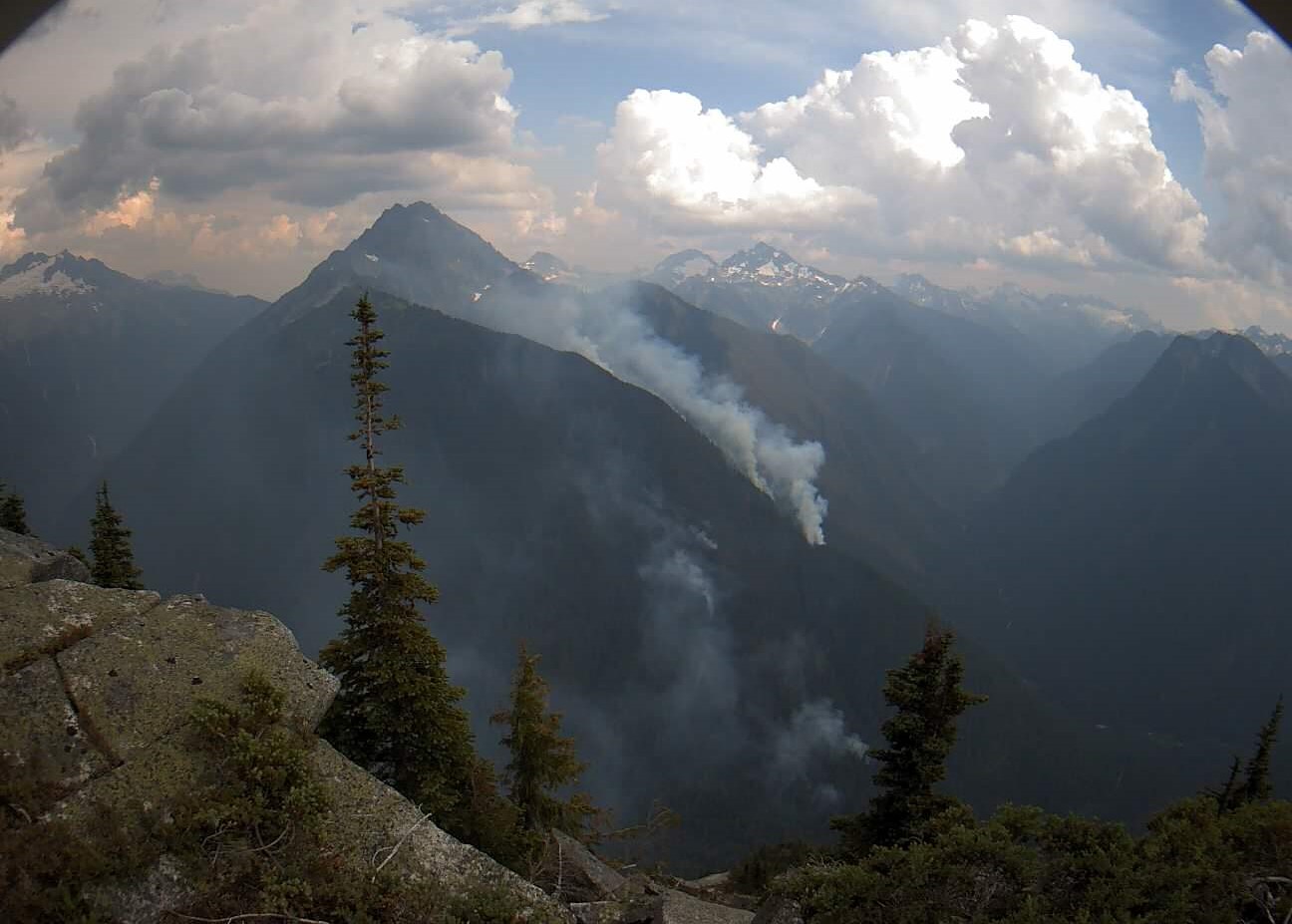
Miners Complex Daily Update 08 11 2024
Related Incident: Miners Complex Fires
Publication Type: Announcement
11:00 AM, August 11, 2024
Estimated size: 642 acres
Start Date/Time: July 17, 2024
Area of Origin: 21 air miles east of Darrington WA
Cause: Lightning
Fuels/Topography: timber, rugged terrain
Structures Damaged: None, there are no homes threatened at this time.
Evacuations: None
The Miners Complex consists of ten wildfires caused by lightning strikes in the Mt. Baker-Snoqualmie National Forest. The fires included in the complex are: Miners Fire, Vista Ridge Fire, Dolly Creek Fire, Sulphur Three Fire, Sulphur Four Fire, Sulphur Thirty-Four Fire, Upper Sulphur Thirty-Two Fire, Lower Sulphur Thirty-Two Fire, Plummer, and Middle Ridge Fire.
Update: Yesterday, the Sulphur fires continued to put up more visible smoke and monitoring continued. The requested reconnaissance flight was cancelled due to weather conditions. Today, monitoring and patrolling will continue as resources are available. Firefighting resources continue to be limited due to the quantity and complexity of other incidents in the region.
Weather: Cooler conditions over the next few days with a trough over the region. Expect excellent humidity recoveries. There is a chance of showers and thunderstorms which may produce gusty and erratic winds. Partly sunny, haze. Chance of showers and thunderstorms in the afternoon. Max temperatures around 75 degrees. Light winds becoming northwest around 6 mph in the afternoon. Gusty and erratic winds expected near thunderstorms in the afternoon.
Smoke: For more information on smoke and air quality please visit: https://wasmoke.blogspot.com/
Closures: The following is a summary of the areas closed due to the fires in the Miners Complex. Pacific Crest National Scenic Trail #2000.2 from Mica Lake to Suiattle Pass, Suiattle River Trail #784, Miners Ridge Trail #785, Buck Creek Pass Trail #789, Miners Cabin Trail #795, Grassy Point Trail #788, Sulphur Mountain Trail #794, Sulphur Creek Trail #793, Sulphur Creek Campground, Sulphur Creek Trailhead, and the Downey Creek trailhead. The full Closure Orders visit: https://www.fs.usda.gov/mbs
Forest Restrictions: The Mt. Baker-Snoqualmie has a full campfire ban and forest-wide shooting restrictions in place to help prevent human-caused starts during this period of unprecedented resource scarcity. Additional details at: www.fs.usda.gov/mbs
###
Falls and Telephone Fires Information Update 08 04 2024
Related Incident: Falls FireTelephone Fire
Publication Type: News
Falls and Telephone Fires Update for Aug 4, 2024
Telephone Fire Quick Facts:
Size: 50,863 Start Date: July 22, 2024 Location: 12 miles NE of Burns, OR
Containment: 23%. Total Personnel: 483 personnel Cause: Lightning/Natural
Resources Assigned: 14 hand crews, 37 engines, 6 bulldozers, 12 water tenders, 4 skidders
Falls Fire Quick Facts:
Size: 146,000 Start Date: July 10, 2024 Location: 13 Miles NW of Burns, OR
Containment: 73% Total Personnel: 1,011 Cause: Human-caused, under investigation
Structures Triaged: Residences: 386; Commercial: 119 Outbuildings: 760
Resources Assigned: 30 hand crews, 48 engines, 15 bulldozers, 22 water tenders, 7 masticators, 7 skidders
Sand Mountain Fire Quick Facts:
Size: 5,805 Start Date: July 25, 2024 Location: 17 miles SW of Seneca, OR
Containment: 0% Total Personnel: Staffed by Falls Fire personnel Cause: Lightning/Natural
Other Fires Quick Facts:
Whiskey Mountain: 4,345 acres; Cow Creek: 86 acres; Parasol: 485 acres; Poison: 1,047 acres; Ritter: 461
Total Personnel: Staffed by Falls Fire personnel.
Aerial resources assigned: 2 Type 1 helicopters and One Type 1 Uncrewed Aircraft System (UAS) assigned and available to all fires in the area.
Community Meetings Scheduled:
Sunday, August 4 at 3 pm, at the Izee Schoolhouse, 45477 Izee Paulina Lane, Izee, OR
Leaders of the Alaska Incident Management Team will be in Izee for a community meeting to provide an update on the Telephone Fire, Falls Fire and several other fires we are working to suppress in the area. The meeting will also be shared on the Malheur National Forest Facebook page, as well as the Falls and Telephone Fires Facebook page.
Priorities for Sunday, August 4:
- Initial Attack (IA): The potential for new fire starts in the area remains significant, and firefighters remain vigilant and focused on IA, ready to respond to any new threats
- Installation of sprinkler kits to structures near the fire perimeter.
- West side of the Telephone Fire
- Gilbert Ridge area
- Northwest side of the Falls/Sand Fires
Fire Summaries:
Telephone Fire:
Despite a weather system that came in yesterday with dry lightning and down drafts, no overall growth was detected on the Telephone Fire. The fire area received 0.1 to 0.2 inch of rain last night, which helped to moderate fuels, slow fire progression, and help firefighters get a foot hold. There is containment line around most of the east side of the fire, and crews have completed tying into Pine Creek on the northeast corner of the fire. Crews are continuing to work on areas of potential threat in the Poujade area. Today, along the eastern side of the fire, crews will continue mopping up to additional depth and taking care of any heat areas detected. On the west side of Telephone, which has had the most significant growth over the last few days, there was a slopover several shifts ago which came up the south side of King Mountain moving toward the south end of Silvies Valley and Purdy Ranch. Crews continue to work that slopover area. There was also some spotting last night near the Rattlesnake area; night shift crews were able to do small-scale ignition operations to address issues, continuing to secure their anchor as they work north, which is extremely important for safety, efficiency, and progress. Crews are scouting this area for opportunities to tie into road systems to go direct where available. Crews will also continue to address the slopover across the 2820 road today. With hot and dry weather conditions, we do expect some growth on the Telephone Fire, and crews are working hard to get containment on some of these features.
Yesterday, structural crews with the Oregon State Fire Marshal (OSFM) successfully defended a home and nearby structures along Roach Creek by utilizing wrap, removing nearby fuels, and holding containment lines around the home and multiple structures on the property. Structural task forces also worked in the northeast and northwest portions of the fire to put out hotspots and prep homes along the 3935 and Purdy Road.
Overnight and through today, task forces will work to complete their structure prep objectives and install sprinkler kits. Sprinkler kits can be a valuable tool to help fire crews protect homes with a smaller number of firefighting resources. Sprinkler systems are tied into nearby water sources or portable tanks and then activated if the fire moves towards structures. Based on progress made in structural protection, the task force from Clatsop County is returning home today, and OSFM will continue to monitor fire progress and conditions to determine if more task forces may be sent back to their home agencies in the coming days.
As fire crews work in the western area of the Telephone Fire, Resource Advisors (READs) and Agency Administrators are in communication with local Tribal representatives to ensure that cultural resources in the area are identified and safeguarded to every extent possible. In addition, resources are also being utilized to address and mitigate environmental impacts on the land as a result of fire suppression efforts. READs work closely with area archeologists, range technicians, and other local experts to coordinate restoration and support the success of the operation.
Falls/Sand Fires:
The Falls and Sand fires are now merged and will be summarized together here going forward. Over the last few shifts, there was some growth on the Sands and Falls Fires with the two merging, and crews are dealing with a few slopovers and spots, and otherwise going direct. “Direct attack” is when firefighters work right on the fire’s edge and do their best to put in dozer line or handline and use fire hose to stop the fire’s spread. On the west side, crews are mopping up further into containment line, and beginning to backhaul equipment. A recent slopover in the Myrtle Creek area was addressed and is holding well, and crews on this side of the fire continue to mop up farther into the containment area. A lot of resources are being used on the northwest edge of the Sand Fire and the most northerly portion of the Falls Fire to protect the community of Izee and other associated values at risk. These fires do have the potential for more growth, in particular going east toward the 31 road and west towards the Gilbert Ridge area. Crews continue working hard to implement contingency plans for this possibility, including creating an anchor point to do small-scale firing ignitions to remove fuel in this area when conditions allow. Night shift crews completed hose lay in the area and are addressing a recent slopover. Work on a large fuel break on the 31 road is nearing completion. This is in preparation for small-scale firing operations which will eliminate fuel using fire between the fire edge and the 31 road. The northeast corner of the Falls Fire area is looking very good. Fire behavior in the area moderated somewhat overnight, and crews are working to attain 100% mop up, which means there are no heats or smokes for a number of shifts, so that this area is secure.
Poison Fire: There was no movement on the Poison Fire despite yesterday’s weather. Crews are continuing to clean up pockets of fuel to more deeply secure the control line.
*Note: The Ritter and Parasol Fires have not had any significant growth outside of containment lines for some time. They are being continuously monitored to check for any heat. Going forward, we will include acreage for these fires in the “Other Fires Quick Facts” section on page, 1, and they will not be summarized here unless there are any changes.
Weather: Today winds will be west/northwesterly, 8-12 mph, with gusts up to 20 mph. Temps will be up to 90 degrees, with relative humidity of 18-25%. Low relative humidity, winds, and column establishment from instability are primary drivers of the fire, and conditions remain supportive for fire growth.
Evacuations: For the most accurate evacuation information, please visit the Harney County Sheriff’s evacuation map here: https://tinyurl.com/3zst4sjy, or the Grant County Emergency Management Facebook page: https://www.facebook.com/profile.php?id=100068819321423.
Closures: A closure is in effect for the two portions of the Malheur National Forest that run west of 395B, north of Mt. Vernon and south of Long Creek, in the Fox Valley area, including all roads, trails, and camping locations within the fire closure area. A detailed map of the closure if included and available on the Malheur National Forest website (https://www.fs.usda.gov/malheur/) and offices.
Investigation: U.S. Forest Service fire investigators are seeking the public’s assistance with any tips or information pertinent to the start of the Falls Fire on the Malheur National Forest. Please submit any information that could assist fire investigation efforts to SM.FS.R6TipHotLine@usda.gov.
Temporary Flight Restriction (TFR): TFRs in the area have been changing; pilots should check the latest information on the Federal Aviation Administration TFR website prior to flying: https://tfr.faa.gov/tfr_map_ims/html/index.html
Facebook: https://www.facebook.com/p/Falls-Fire-2024-61562126623985/
Falls Fire InciWeb: https://inciweb.wildfire.gov/incident-information/ormaf-falls-fire
Telephone Fire InciWeb: https://inciweb.wildfire.gov/incident-information/ormaf-telephone-fire
Fire Information Line: 541-208-4370, staffed 8 a.m. to 8 p.m.
Email: 2024.Falls@firenet.gov
Harney County non-emergency evacuation questions: 541-589-5579
Air quality questions: 541-573-2271. Air quality information, searchable by zip code: https://fire.airnow.gov/
Smoke Outlooks: https://outlooks.airfire.org/outlook
Apache PostFire BAER Soil Burn Severity Map Released 08 04 2024
Related Incident: Lake and Apache Post-Fire BAER
Publication Type: News
LAKE & APACHE POST-FIRE BAER ASSESSMENT UPDATE
August 4, 2024
Apache Post-Fire BAER Soil Burn Severity Map Released
Forest Service Burned Area Emergency Response (BAER) specialists recently completed their data gathering and analysis for the Apache burned area to produce and finalize a soil burn severity (SBS) map. Forest Service BAER teams use the soil burn severity assessment of the burned area to ensure post-fire threats are identified.
The SBS map and data display categories of unburned/low, moderate, and high. Approximately 37% of the total 1,532 acres analyzed are either unburned and/or low soil burn severity, while 62% sustained a moderate soil burn severity, and only about 1% identified as high soil burn severity. All 1,532 acres that were burned in the Apache Fire were National Forest System lands.
The BAER assessment team used initial remote sensing imagery with their field validated soils data, to develop and produce a map showing soil burn severity levels for the burned areas The SBS is broken into four different classes: unburned (green), low severity (blue), moderate severity (yellow), and high severity (red). For more information on what these different SBS classifications mean, see BAER Information Brief at: Calpf Lake And Apache Postfire Baer - | InciWeb (wildfire.gov).
The BAER team relied on their refined soil burn severity map to produce data which they are using in their subsequent modeling and determination of post fire runoff and sedimentation. The BAER teams and the US Geological Survey (USGS) both utilized the soil burn severity map as an analysis tool to estimate post-fire flows and debris flow probability. In specific areas that experienced moderate to high burn severity, there could be increased runoff from steep hillslopes and resultant increases in post-fire soil erosion and potential debris flows.
The Apache post-fire soil burn severity (SBS) map can be downloaded at the Lake and Apache BAER InciWeb site: Calpf Lake And Apache Postfire Baer Information | InciWeb (wildfire.gov) as a JPEG or PDF version under the “Maps” tab.
BAER SAFETY MESSAGE: Everyone near and downstream from the burned areas should remain alert and stay updated on weather conditions that may result in heavy rains and increased water runoff. Flash flooding may occur quickly during heavy rain events--be prepared to act. Current weather and emergency notifications can be found at the National Weather Service website: www.weather.gov/lox/.
###
Cottage Grove Lane 1 Fire Update 08 04 2024
Related Incident: Lane 1 Fire
Publication Type: News
Cottage Grove – Lane 1 Fires Daily Update – Sunday, August 4, 2024
The Cottage Grove – Lane 1 Fires are a total of 13,903 acres and is considered 9% contained. Percent containment represents sections of fire line that pose no escape risk without further action from firefighters. There are currently 1263 personnel assigned to the incident.
Firefighters will continue conducting burnout operations over the next several days utilizing existing and incoming surge resources as weather conditions allow. Firefighters are conducting the burnouts during the swing shift and will hold during the day and night shifts.
Closures: Due to the wildfires, the Umpqua National Forest has issued Forest Order No. 06-15-24-03 and Forest Order No. 06-15-02-24-01 that can be found at: https://www.fs.usda.gov/aler/umpqua/alerts-notices.
The Bureau of Land Management has issued the following emergency closure for Lane County: https://www.blm.gov/announcement/bureau-land-management-expands-emergency-fire-closure-due-cottage-grove-lane-1-fire
The following County roads are closed except to owners of private lands accessed from these roads: Brice Creek Road east of Umpqua National Forest Boundary, all of Sharps Creek Road.
Evacuations: A “Level 2” evacuation notice is in effect for the Bohemia Mining District and Fairview Peak. Additionally, a “Level 1” evacuation notice has been issued by the Lane County Sheriff’s Department for areas east of Disston, starting at Brice Creek Road milepost 0.7 and following Brice Creek Road south. An evacuation map is available at: www.LaneCountyOR.gov/Lane1Fire.
Temporary Flight Restriction (TFR): A “TFR” is in place at an altitude from the surface up to and including 8500 feet, daily (24 hours) until further notice. Complete information is available at https://tfr.faa.gov/save_pages/detail_4_4814.html. Flying a drone near or around a wildfire compromises the safety of pilots and interferes with firefighting efforts.
For further information visit the Inciweb links for each Cottage Grove-Lane 1 fires below:
Lane 1: https://inciweb.wildfire.gov/incident-information/or77s-Cottage-Grove-lane-1
Adam Mountain: https://inciweb.wildfire.gov/incident-information/orupf-adam-mountain
Hours: 8:00 AM – 8:00 PM E-mail: 2024.lane1@firenet.gov
Facebook: http://www.facebook.com/CottageGroveLane1Fires2024
Cottage GroveLane 1 Update 842024 08 04 2024
Related Incident:
Publication Type: News
Cottage Grove – Lane 1 Fires Daily Update – Sunday, August 4, 2024
The Cottage Grove – Lane 1 Fires are a total of 13,903 acres and is considered 9% contained. Percent containment represents sections of fire line that pose no escape risk without further action from firefighters. There are currently 1263 personnel assigned to the incident.
Firefighters will continue conducting burnout operations over the next several days utilizing existing and incoming surge resources as weather conditions allow. Firefighters are conducting the burnouts during the swing shift and will hold during the day and night shifts.
Closures: Due to the wildfires, the Umpqua National Forest has issued Forest Order No. 06-15-24-03 and Forest Order No. 06-15-02-24-01 that can be found at: https://www.fs.usda.gov/aler/umpqua/alerts-notices.
The Bureau of Land Management has issued the following emergency closure for Lane County: https://www.blm.gov/announcement/bureau-land-management-expands-emergency-fire-closure-due-cottage-grove-lane-1-fire
The following County roads are closed except to owners of private lands accessed from these roads: Brice Creek Road east of Umpqua National Forest Boundary, all of Sharps Creek Road.
Evacuations: A “Level 2” evacuation notice is in effect for the Bohemia Mining District and Fairview Peak. Additionally, a “Level 1” evacuation notice has been issued by the Lane County Sheriff’s Department for areas east of Disston, starting at Brice Creek Road milepost 0.7 and following Brice Creek Road south. An evacuation map is available at: www.LaneCountyOR.gov/Lane1Fire.
Temporary Flight Restriction (TFR): A “TFR” is in place at an altitude from the surface up to and including 8500 feet, daily (24 hours) until further notice. Complete information is available at https://tfr.faa.gov/save_pages/detail_4_4814.html. Flying a drone near or around a wildfire compromises the safety of pilots and interferes with firefighting efforts.
For further information visit the Inciweb links for each Cottage Grove-Lane 1 fires below:
Lane 1: https://inciweb.wildfire.gov/incident-information/or77s-Cottage-Grove-lane-1
Adam Mountain: https://inciweb.wildfire.gov/incident-information/orupf-adam-mountain
Hours: 8:00 AM – 8:00 PM E-mail: 2024.lane1@firenet.gov
Facebook: http://www.facebook.com/CottageGroveLane1Fires2024
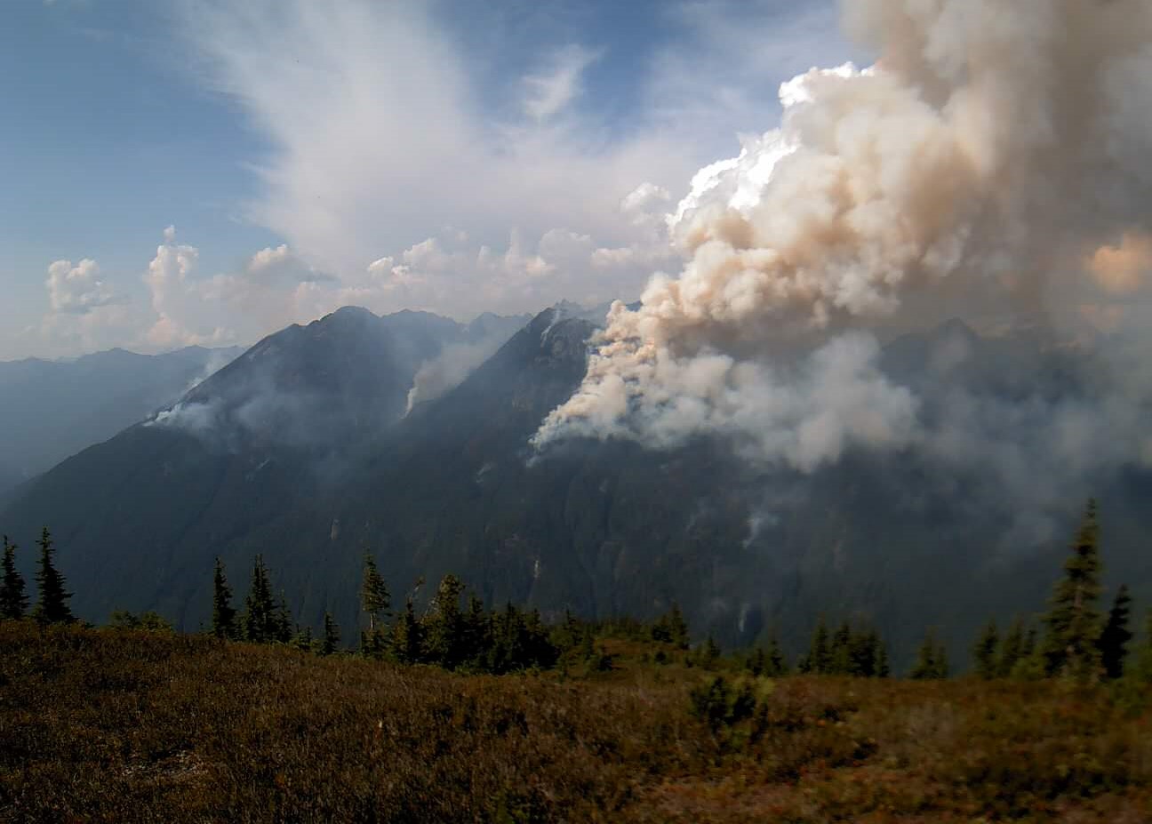
Grouse Fire Update 08 04 2024
Related Incident: Grouse
Publication Type: News
GROUSE FIRE UPDATE
Incident Commander: R. Griffin, C. Olander, (T)
Location: 10 miles southwest of Wise River, MT
Start Date: 7/25/2024
Cause: Undetermined
Size: 2,097 acres
Resources on Site: 2 hotshot crews; 2 type 2 hand crews; 7 engines; 2 skidgens; 1 dozer
Total Personnel: 232
KEY MESSAGES:
A Community Meeting will be held on Monday, August 5, 2024 at the Wise River Community Foundation Building at 6:00 p.m. MDT. An Area/Road/Trail Closure is in effect for the vicinity of the fire perimeter on the west side of the Pioneer Mountains Scenic Byway.
The Pioneer Mountains Scenic Byway remains OPEN. Those recreating or traveling in the fire area are encouraged to be aware of the situation and to pay attention to increased fire traffic. If traveling in the area please slow down, drive 35 MPH, and yield to firefighting equipment, engines, and vehicles.
CURRENT STATUS/PLANNED ACTIONS:
An Incident Awareness and Assessment (IAA) Flight flew the fire perimeter yesterday and mapped the fire at 2,097 acres.
The Flathead Interagency Hotshot Crew (IHC) continue constructing fireline on the north flank of the fire by Stine Mountain progressing east. The hotshots will continue scouting for opportunities for a more direct (closer to the fire’s active edge) approach on the north and east flanks. A Sikorsky helicopter (also known as a skycrane) assisted with water drops to cool fireline construction. The skycrane holds roughly 2,000 gallons of water and with the current elevation, is averaging 700 to 1,200 gallons.
There has been active fire behavior for multiple days, with torching, flanking, spotting and uphill runs. Hand crews continue to secure and “mop-up” all residual heat along the edges, working from the southeast side of the fire and progressing east towards the residences near Pettengill Road. These actions are to keep the fire west of the Pioneer Mountains Scenic Byway and protect private property in the Pettengill Creek Drainage.
The Bonneville Interagency Hotshot Crew (IHC) continues working with structure protection equipment (pumps, hoses, and sprinklers) near residences in the Pettengill Creek area. On the eastern edge of the fire perimeter, crews are using existing and improved control features (such as prepped firelines) to prevent fire spread to the north and east, to suppress spot fires, and extinguish hot spots to protect private property along Pettengill Creek. Fire managers will scout for opportunities on the southern and southwest flanks of the fire in the Pettengill Creek drainage. Smoke is still visible throughout the Pioneer Mountains Scenic Byway and Wise River vicinity.
WEATHER AND FIRE BEHAVIOR:
Saturday was hot with breezy conditions. A trough moved in last night, bringing increased clouds, wind, rain and thunderstorms. Sunday is forecasted for cooler temperatures, with a chance of thunderstorms again on Monday. Active fire behavior is expected to continue with movement primarily up the Grouse Creek drainage and sub-drainages.
CLOSURES AND RESTRICTIONS:
The Beaverhead-Deerlodge National Forest has issued an Area/Road/Trail Closure (Closure #01-02-03-24-05) effective July 31, 2024. This Order is for public and firefighter safety during fire suppression efforts of the Grouse Fire. Closure information and maps are posted on the Forests’ website and the fire’s Inciweb page as they are in place. https://inciweb.wildfire.gov/incident-information/mtbdf-grouse.
A Temporary Flight Restriction (TFR) is in place over the fire area.
The Forest is in Stage 1 Fire Restrictions. Campfires are allowed only in a permanent metal fire grate/ring provided by the Forest Service in a designated, developed recreation site. Smoking is restricted to vehicles, in buildings, or in an area clear of flammable materials. Devices with an on/off switch that use LPG fuels are allowed in an area clear of flammable materials within 3 feet of the device.
Homestead Complex Daily Update 08 04 2024
Related Incident:
Publication Type: News
HOMESTEAD COMPLEX
FIRE UPDATE
Fire Information Sunday, August 4, 2024
Phone: 541-208-7100 (8 a.m. to 8 p.m.)
Email: 2024.homesteadcomplex@firenet.gov
Facebook: www.facebook.com/HomesteadComplexFireInfo
Inciweb: http://inciweb.wildfire.gov/incident-information/orupf-homestead-complex
Smoke Outlook: https://outlooks.airfire.org/outlook/d393fd74
Containment Progress on Horse Heaven Creek Fire
The Homestead Complex includes seven fires that total 2,535 acres and are currently 9% contained. There are 483 personnel currently working on the fire. Fire managers are directing resources to fires based on threats to property, infrastructure, industry, and areas with the highest probability of success.
Crews were able to declare containment on the majority of the west flank of the Horse Heaven Creek Fire (710 acres) yesterday. Today, crews will continue to patrol and improve the fireline in that area. They will also be putting in handline towards the southeast corner of the fire to create opportunities to go direct.
There was no lightning reported within the Homestead Complex area yesterday. A light rain fell throughout the area, which helped to moderate the fire activity as the storm moved through. There remains a chance of thunderstorm activity in the region, but the effects are expected to be limited. A warming and drying trend will likely lead to moderate fire behavior in the coming days.
As storm systems move through the area again today, two hotshot crews on the No Man Fire (949 acres) will continue partnering with Douglas Forest Protective Association to improve firelines on the west flank. They will be securing any spot fires and continuing building contingency line. An Unmanned Aircraft System (UAS) module is supporting the operations on the No Man Fire. The priorities in this area remain protecting important values including private and forest timber, communications infrastructure, and wildlife habitat.
Crews on the Bullpup Fire (208 acres) completed road prep on the northwest side of the fire and will be focusing on the southwest side today. On the Fuller Lake Fire (133 acres), crews will be prepping the 200 Road to use as a containment feature. On the Reynolds Butte Fire (300 acres) and Salmon 33 Fire (201 acres), crews are patrolling and continuing to improve containment lines. Strengthening these existing features is safer, more efficient, and more effective than constructing direct line in steep, rugged, remote terrain.
The Lost Bucket Fire (34 acres) was contained on July 29 and continues to show minimal fire activity.
Current forest fire restrictions and danger ratings are: Fire Danger Rating: Very High. Industrial Fire Precaution Levels (IFPLs): 3. Public Use Fire Restrictions (PURs): 3.
CLOSURES: The Bureau of Land Management (BLM), Roseburg District, has issued a closure order for portions of BLM land which border the Umpqua National Forest Emergency Fire Closure north of Steamboat. The closure order can be viewed here: https://www.blm.gov/sites/default/files/docs/2024-07/orwa-fpo-rbg-072624.pdf. Umpqua National Forest Emergency Fire Closure ORDER NO. 06-15-24-03 and ORDER NO. 06-15-02-24-01 remain in effect and can be found here: https://www.fs.usda.gov/alerts/umpqua/alerts-notices.