
Microwave Tower Fire Update Friday 08 02 2024
Related Incident: Microwave Tower Fire
Publication Type: News
Size: 1,311 acres
Start Date: July 22, 2024
Cause: Undetermined
Location: 5 miles west of Mosier, OR
Containment: 84%
Fuels: Brush, timber, and grass
Highlights:
Crews were successful with tactical firing of interior pockets yesterday. This tactic was used to decrease the amount of unburned vegetation and will help decrease the amount of active fire and smoke within the perimeter. Firefighters continued mopping up along the fire line and were able to increase containment to 84%.
Operations:
Yesterday, crews monitored and patrolled the fire’s perimeter. Along the southern line, engine crews mopped up an interior hot spot burning in mixed conifer fuel type. On the northwestern line, terrain is steep with rolling rocks and debris hazards. Hand crews mopped up as needed and where safety permitted. The fire line was improved along the northeastern edge of the fire.
Today, crews will continue to monitor the entire fire’s perimeter to ensure continued security of lines, extinguish hot spots where accessible, and work to increase containment from Old Hwy 30 to I-84.
Fire Behavior and Weather:
Hot and dry conditions are forecasted again for today, and residual pockets of vegetation will continue to burn producing visible smoke and potential flames. Drivers are asked to please use caution on Interstate 84 as firefighters are still working in the area.
Evacuations:
Level 2 and 1 evacuations remain in effect for Wasco County: https://www.facebook.com/WascoCountySheriff
Level 1 evacuations remain in effect for Hood River County: https://www.facebook.com/hrcso
Road and Trail Closures:
For public and firefighter safety, closures are in place for The Historic Columbia River Highway State Trail and for roads in Hood River County. Details of these closures are available on their websites: https://www.hoodrivercounty.gov/closures and https://stateparks.oregon.gov/
To stay informed on the most up-to-date road conditions on Interstate 84, visit https://tripcheck.com/
Total Fire Resources Assigned:
Approx. 123 personnel, 4 hand crews, 9 engines, 2 water tenders, 3 dozers, and 1 skidder.
Contact Information:
Email: 2024.microwavetower@firenet.gov,
Phone: 541-208-1744, 8 A.M - 8 P.M,
Battle Mountain Complex 08 02 2024
Related Incident: Battle Mountain Complex
Publication Type: News
Progress continues on the Battle Mountain Complex, firefighters prepare for Red Flag Conditions.
UKIAH, Ore. – Firefighters continue to make strides holding lines and building containment on the Battle Mountain Complex as they prepare for rising temperatures and Red Flag Conditions today.
Temperatures have been rising steadily and are expected to crest 100 degrees today. Fire officials also expect wind gusts up to 20 miles per hour in addition to limited visibility from smoke from other fires in the region. High temperatures are expected to persist through next week with lightning possible this weekend.
Today, firefighters will focus on gaining mop-up depth and cooling materials deeper from the perimeter along the entire fire. As temperatures rise, mop up helps ensure that any reheated or ignited materials can’t escape the fire perimeter.
In Zone I, crews continue mopping up around structures and extending containment. Firefighters will continue mopping up along the southeast corner of the Monkey Creek fire near Monument. They’re also focused on securing containment along the north.
In Zone II, firefighters are focused on the north-central region between Ditch Creek and the Potamus drainage as they look to bring the fire to control features where they can stop the fire.
Residents should continue to expect to see smoke in the interior and the unburnt island within the fire perimeter as unburnt vegetation burns well within the fire’s footprint. Crews will continue to patrol the fire’s perimeter, including portions considered contained.
Oregon Department of Forestry Incident Management Team 1 will transfer command of the Monkey Creek Fire to ODF Incident Management Team 3 tonight at 6:00 pm. This will put Team 3 in command of the entire fire.
Evacuations: Learn more about current evacuation levels for each county at:
- For Umatilla County, follow www.facebook.com/UmatillaCountySheriff or sign up for Umatilla County Emergency Alert System at https://member.everbridge.net/index/2590041373147145.
- For Grant County, visit the RAPTOR arcgis site or sign up for alerts at: https://member.everbridge.net/index/825462649520134.
- For Morrow County, visit https://experience.arcgis.com/experience/de78333b0d2544f7a320142174aa20ae
Public Land Closures:
The Bureau of Land Management has closed public lands along the John Day River from Kimberly to Dale, and from Kimberly to Service Creek. More information here: https://www.blm.gov/programs/public-safety-and-fire/fire-and-aviation/regional-info/oregon-washington/fire-restrictions.
The Umatilla National Forest has implemented a closure for public lands within the Heppner Ranger District and the North Fork John Day Ranger District. More information at: https://www.fs.usda.gov/detail/umatilla/news-events/?cid=FSEPRD1194462 and https://www.fs.usda.gov/detail/umatilla/alerts-notices/?cid=stelprdb5286768.
FIRE AT A GLANCE
Total Estimated Complex Size: 179,080 acres
Monkey Creek Fire: 174,596
North Fork Owens: 4,484 acres
Total Containment 23%
Cause: Under Investigation
Estimated Cost: $36,299,415
All Resources
Hand Crews: 65
Engines: 81
Water Tenders: 39
Dozers: 28
Helicopters: 6
Total Personnel: 2,029
Durkee Fire Daily Update for August 2 2024 08 02 2024
Related Incident: Durkee Fire
Publication Type: News
DURKEE FIRE
Size: 293,882 acres Containment: 63% Location: 1 mile west of Durkee, OR
Start Date: July 17, 2024 Personnel: 439 Cause: Lightning
DURKEE FIRE PUBLIC MEETING – FRIDAY AUGUST 2, 2024, at 6 p.m. PDT
On Friday August 2 at 6 p.m. PDT a public meeting on the Durkee Fire will be held at the Churchill School, 3451 Broadway St., Baker City, OR.
Current Situation
For everyone’s safety, please slow down when driving near firefighters and equipment in the fire area.
Firefighters have continued to steadily increase containment this week. Despite the hotter and drier conditions, there were no concerns about the containment lines holding. There is heat in the interior of the fire on hillsides and riparian areas, some of which flared up yesterday, but the edges of the fire area are cold. On the south and east sides of the fire, firefighters are in full patrol mode using a technique called gridding. They search an area by systematically traveling on parallel courses or gridlines to make sure there is no heat. Crews also mopped up on the fire’s edges on the north and northwest sides. East of Bridgeport, firefighters mopped up heat in interior drainages.
Today, firefighters will inspect and work to eliminate heat sources identified on last night’s infrared flight. They will also patrol parts of the interior fire area and check to make sure there is no heat that was not captured in the infrared data in riparian areas and around structures and roads. Crews also will check the edge of the fire area to make sure containment lines are secure and will continue removing excess equipment where it is no longer needed. Firefighters will continue mopping up riparian areas between Bridgeport and Burnt Cabin Road. An Uncrewed Aircraft System (UAS or drone) map be used on the northwest side of the fire to help pinpoint remaining heat so firefighters can target those areas for mop up. A reconnaissance flight is planned for this afternoon.
The night shift will end early tonight so they can start work earlier on Saturday in response to the drier weather expected over the weekend. This will increase staffing on the fire during peak burning conditions and provide additional support for any potential initial attack if there are new starts.
Weather and Fire Behavior
The National Weather Service has issued an excessive heat warning. Temperatures of 105-110 degrees are possible today. Relative humidity will be critically low with minimums of 10-15% expected and single digit relative humidities in isolated exposed pockets. During the day winds will be light but may increase after sunset with northwesterly winds in the northwest part of the fire and down the I-84 corridor gusting 20-25 mph. Smoke, smoldering and flareups are likely today in the fire area. Additionally, an increase in smoke from other fires in the region is expected to affect this fire area today due to air flow aloft coming from the south to southwest. Overnight lows will be in the range of 70-75 degrees. Saturday has a potential for dry lighting and gusty outflow winds.
Evacuations
The Malheur County Sheriff’s Office (https://www.facebook.com/profile.php?id=100069245917855) and the Baker County Sheriff’s Office (https://www.facebook.com/profile.php?id=100064434892363) have issued evacuation orders for multiple areas during the Durkee Fire. Please continue to be vigilant and stay tuned to their Facebook pages for the latest information. Weather patterns and fire activity may lead to an increase in evacuation levels.
Residents in Level 3 Evacuations “GO NOW” should leave immediately and not return to their property until evacuation levels are lowered. Carry enough supplies to support you and your family for multiple days. A real-time map of fire evacuations is available on the State of Oregon Fire Dashboard (https://www.arcgis.com/apps/instant/portfolio/index.html?appid=22d04c007866419c91ccf00d097526c8).
Closures
- The Baker County Sheriff's Office has closed Burnt River Canyon Road to non-local, non-emergency traffic.
- I-84 and other highways: Please go to tripcheck.comfor current road closures as the situation is dynamic and subject to change.
- A burn ban is currently in effect for all of Malheur County (https://www.malheurco.org/category/public-notices), and all Bureau of Land Management lands in Malheur and Baker counties.
- The temporary flight restriction has been adjusted over the Durkee Fire. More information is available at https://tfr.faa.gov/save_pages/detail_4_2107.html. Remember, if you fly we can’t! If a drone or other aircraft enters the air space, all firefighting aircraft will be grounded.
Additional Resources
- For current air quality information, visit fire.airnow.gov.
- Weather and fire behavior could impact transportation, power transmission, cell service and other utilities. Monitor IdahoPower.com for information.
- Post-fire resources for eastern Oregon livestock and agricultural producers are available. For immediate assistance associated with livestock, forage, and crop losses contact your county’s USDA Farm Service Agency (FSA) office. Learn more about these and other disaster relief programs at www.farmers.gov/protection-recovery/wildfire and contact your FSA Service Center.
- For technical expertise regarding livestock, post-fire rehabilitation and land management, call Eastern Oregon Agricultural Research Center at (541) 573-8900.
- Questions related to agriculture and natural resources, family and community health, and more may be directed to the OSU Extension Service office in your county (https://extension.oregonstate.edu/find-us).
- If you don’t have access to a computer and/or internet connection, Extension offices house Ag Disaster Relief Resource Computers, which are available to producers to access federal/state relief programs.
- Oregon Wildfire Response & Recovery website (wildfire.oregon.gov/recovery) provides guidance on topics including wildfire insurance, filing a homeowners claim after the fire, returning to a home that survived a fire, replacing lost or missing documents and next steps for people whose homes or businesses burned.
- For longer term management needs, contact the USDA Natural Resource Conservation Service (NRCS) field office in your county to explore current funding/technical support available and inform future program offerings in your county. Go to www.nrcs.usda.gov/conservation-basics/conservation-by-state/oregon/whats-available-in-my-county.
Actualizacin diaria del incendio Pioneer 2 de agosto de 2024 08 02 2024
Related Incident:
Publication Type: News
Actualización diaria del incendio Pioneer
2 de agosto de 2024
Datos clave
Tamaño: 33,761 (No updated IR)
Fecha de inicio: 8 de junio de 2024
Ubicación: 31 millas al NO de Chelan, WA
Contención: 12%
Personal: 644
Causa: De orígen humano, a ser determinada
Recursos asignados: 11 cuadrillas, 4 helicópteros, 26 camiones de bomberso, 28 tanques de agua, 17 maquinarias pesadas
El Equipo 3 del Noroeste se está preparando para transicionar la gestión de los incendios Pioneer e Easy al Equipo 15 de California el sábado a las 6 AM. Ayer se actualizó al equipo entrante sobre la situación actual y los objetivos operativos, y hoy "seguirá" al Equipo 3 para evitar problemas con la transición.
SITUACIÓN ACTUAL: Estuvo activo el incendio en el extremo sur de Hazard Creek, donde un tronco que retenía calor rodó hacia un pequeño desague lateral y quemó combustibles no quemados en un área de unos 10 acres. Se usaron helicópteros y aviones lanzadores de agua para contener el fuego. Las condiciones calientes y secas causaron que se activaran las áreas ardientes en los desagues de Upper Fish Creek y Fourmile y resultó en una columna de humo. En los próximos días se espera un aumento en el fuego por el lado norte del incendio y se prevé un clima cálido y seco.
En Stehekin, las cuadrillas siguen probando mangueras y rociadores en la línea de protección comunitaria y alrededor de las casas. La preparación de estructuras y las líneas de protección comunitaria se están ampliando valle arriba. En la ladera sur del incendio, la maquinaria pesada siguió trabajando en el cortacombustible sombreado en Cooper Ridge. Las cuadrillas astillaron los árboles que se habían removido y los transportaron fuera del sitio. Continúa el trabajo en las carreteras en Gold Creek y Black Canyon para reducir los impactos del uso de las maquinarias pesadas y para garantizar la entrada y salida de los bomberos.
ACTIVIDADES DE HOY: Las cuadrillas continuarán el trabajo de neutralización y patrullando la orilla del lago desde Fourmile Creek hasta el lago y si es necesario realizarán operaciones estratégicas de quema al norte de Fourmile Creek para proteger las estructuras a lo largo de la orilla del lago. Los recursos de aviación continuarán apoyando a los bomberos al transportar cuadrillas y vertiendo agua para frenar el desplazo del fuego hacia el norte. En Stehekin, los bomberos continuarán protegiendo estructuras, incluyendo extendiendo la línea de protección comunitaria valle arriba más allá del área de Rainbow Falls. Un equipo adicional de interagencial Hot Shot llegó ayer para ayudar con las actividades de extinción en Stehekin y las operaciones de quema.
CLIMA Y HUMO: Ayer, las temperaturas alcanzaron los 101 grados en Stehekin. El Servicio Meteorológico ha emitido una advertencia de bandera roja por causa de las condiciones climáticas más calurosas, secas e inestables de viernes a domingo. Esta tarde o a primera hora de la noche existe un 20% de probabilidad de tormentas eléctricas. También se ha emitido una alerta de calor excesivo para el viernes y el sábado. Consulte el Pronóstico actual del humo para el centro norte de Washington (airfire.org) para más información sobre el humo y la calidad del aire.
EVACUACIONES: Los niveles 1, 2 y 3 de evacuación siguen vigentes alrededor del incendio Pioneer. Visite https://t.ly/QoH9w para tener más información.
CIERRE DEL BOSQUE: Cierres vigentes del Parque nacional North Cascades: https://www.nps.gov/noca/index.htm
El Bosque Nacional Okanogan-Wenatchee ha emitido una orden de cierre sobre gran parte del área afectada por el incendio: https://bit.ly/PioneerClosure. Las fogatas están prohibidas. Hay una restricción temporal de vuelo (TFR, en inglés) sobre el área del incendio: https://tfr.faa.gov/save_pages/detail_4_6779.html. La actividad de drones no autorizados está prohibida por la TFR.
InciWeb: https://inciweb.wildfire.gov/incident-information/wases-pioneer
Facebook: https://www.facebook.com/profile.php?id=61560760893080
Línea de información sobre el incendio: 541-861-5808, de 8 AM a 8 PM
Correo electrónico: 2024.pioneer@firenet.gov
Actualizacin del incendio Easy 2 de agosto de 2024 08 02 2024
Related Incident: Easy Fire
Publication Type: News
Actualización diaria del incendio Pioneer
2 de agosto de 2024
Datos clave
Tamaño: 33,761 (No updated IR)
Fecha de inicio: 8 de junio de 2024
Ubicación: 31 millas al NO de Chelan, WA
Contención: 12%
Personal: 644
Causa: De orígen humano, a ser determinada
Recursos asignados: 11 cuadrillas, 4 helicópteros, 26 camiones de bomberso, 28 tanques de agua, 17 maquinarias pesadas
El Equipo 3 del Noroeste se está preparando para transicionar la gestión de los incendios Pioneer e Easy al Equipo 15 de California el sábado a las 6 AM. Ayer se actualizó al equipo entrante sobre la situación actual y los objetivos operativos, y hoy "seguirá" al Equipo 3 para evitar problemas con la transición.
SITUACIÓN ACTUAL: Estuvo activo el incendio en el extremo sur de Hazard Creek, donde un tronco que retenía calor rodó hacia un pequeño desague lateral y quemó combustibles no quemados en un área de unos 10 acres. Se usaron helicópteros y aviones lanzadores de agua para contener el fuego. Las condiciones calientes y secas causaron que se activaran las áreas ardientes en los desagues de Upper Fish Creek y Fourmile y resultó en una columna de humo. En los próximos días se espera un aumento en el fuego por el lado norte del incendio y se prevé un clima cálido y seco.
En Stehekin, las cuadrillas siguen probando mangueras y rociadores en la línea de protección comunitaria y alrededor de las casas. La preparación de estructuras y las líneas de protección comunitaria se están ampliando valle arriba. En la ladera sur del incendio, la maquinaria pesada siguió trabajando en el cortacombustible sombreado en Cooper Ridge. Las cuadrillas astillaron los árboles que se habían removido y los transportaron fuera del sitio. Continúa el trabajo en las carreteras en Gold Creek y Black Canyon para reducir los impactos del uso de las maquinarias pesadas y para garantizar la entrada y salida de los bomberos.
ACTIVIDADES DE HOY: Las cuadrillas continuarán el trabajo de neutralización y patrullando la orilla del lago desde Fourmile Creek hasta el lago y si es necesario realizarán operaciones estratégicas de quema al norte de Fourmile Creek para proteger las estructuras a lo largo de la orilla del lago. Los recursos de aviación continuarán apoyando a los bomberos al transportar cuadrillas y vertiendo agua para frenar el desplazo del fuego hacia el norte. En Stehekin, los bomberos continuarán protegiendo estructuras, incluyendo extendiendo la línea de protección comunitaria valle arriba más allá del área de Rainbow Falls. Un equipo adicional de interagencial Hot Shot llegó ayer para ayudar con las actividades de extinción en Stehekin y las operaciones de quema.
CLIMA Y HUMO: Ayer, las temperaturas alcanzaron los 101 grados en Stehekin. El Servicio Meteorológico ha emitido una advertencia de bandera roja por causa de las condiciones climáticas más calurosas, secas e inestables de viernes a domingo. Esta tarde o a primera hora de la noche existe un 20% de probabilidad de tormentas eléctricas. También se ha emitido una alerta de calor excesivo para el viernes y el sábado. Consulte el Pronóstico actual del humo para el centro norte de Washington (airfire.org) para más información sobre el humo y la calidad del aire.
EVACUACIONES: Los niveles 1, 2 y 3 de evacuación siguen vigentes alrededor del incendio Pioneer. Visite https://t.ly/QoH9w para tener más información.
CIERRE DEL BOSQUE: Cierres vigentes del Parque nacional North Cascades: https://www.nps.gov/noca/index.htm
El Bosque Nacional Okanogan-Wenatchee ha emitido una orden de cierre sobre gran parte del área afectada por el incendio: https://bit.ly/PioneerClosure. Las fogatas están prohibidas. Hay una restricción temporal de vuelo (TFR, en inglés) sobre el área del incendio: https://tfr.faa.gov/save_pages/detail_4_6779.html. La actividad de drones no autorizados está prohibida por la TFR.
InciWeb: https://inciweb.wildfire.gov/incident-information/wases-pioneer
Facebook: https://www.facebook.com/profile.php?id=61560760893080
Línea de información sobre el incendio: 541-861-5808, de 8 AM a 8 PM
Correo electrónico: 2024.pioneer@firenet.gov
Final Update Lower Granite Fire 08 02 2024
Related Incident: Lower Granite Fire
Publication Type: News
News Release – Lower Granite Fire
FINAL UPDATE
August 2, 2024
Pomeroy, WA: On July 29th, 2024 around 11:42 am The Lower Granite Fire ignited. The fire quickly spread east with strong, gusty winds, threatening croplands, cattle, rangeland and structures. Initially, Garfield County Fire District 1 responded to the incident, working with local farmers and ranchers to prevent additional fire progression. As the fire continued to grow, aerial support and additional resources were requested. Washington State Patrol authorized the response of state firefighting resources, mobilizing four strike teams of district fire engines to respond to the fire.
Aviation assets began fire retardant drops around structures at risk, while Initial Attack crews worked the active fire zone.
The Northeast Washington Incident Management Team Type 3 Team 1, took command of the fire on Tuesday, July 30th at 10:00am. Aviation and ground operations began immediately to identify unburned fuels, hazard zones, and mitigate hotspots. Initial assessment identified structures, rangeland, crops, and cattle within the fire zone. Concentrated efforts in the Kluge Canyon area just north of Tramway Road, northern flank fire line on Wawawai Grade Road, and on the south flank fire line on Kirby-Mayview Road prevented the fire from growing. Crews worked on the interior to clear hotspots that threatened unburned fuels.
During fire operations, it was discovered that a large area of unburned fuels located in the canyon between the Snake River and the Uplands on Mayview road posed a high risk to the community, firefighters, and rangeland if left untreated. As a precaution, fire mitigation strategies were implemented to reduce the risk of flareups while also helping secure and maintain the fire line.
On Thursday, August 1, 2024 at 8:00 am fire evacuation levels were downgraded to level 1. As of 7pm that evening the Lower Granite Fire was 59% contained, with 144 personnel assigned to the incident.
Crews worked throughout the night and into the following day on the south flank on Wawawai Grade Road, and along the south flank on Kirby-Mayview Road while other crews worked along the fire perimeter continuing to address hotspots, snags, and checking structures for continued heat 300 feet round the perimeters.
Around 1 pm that afternoon, fire crews reported increased fire activity in the canyon between the Uplands and Snake River area. Smoke was visible as fire crews engaged these flareups with in the canyon. Aviation assets performed water drops, as hand crews monitored and secured the perimeter preventing embers from breaching the Uplands plain. Crews monitored the canyon overnight for any additional activity.
On August 3rd, Wildland crews will begin demobilizing with the fire command being turned over to local officials with anticipated containment goals of 99% by this evening. The Garfield County Fire District 1 will resume command.
The Northeast Incident management Team Type 3 Team 1, would like to thank the town of Pomeroy and the surrounding communities for their support and hospitality in helping make this operation successful.
Current evacuations are updated on the Garfield County Sheriff's Facebook page at:
https://www.facebook.com/GarfieldCountySheriff
Grouse Fire Update 08 02 2024
Related Incident: Grouse
Publication Type: News
Grouse Fire Update
Incident Commander: R. Griffin, C. Olander, (T)
Location: 10 miles southwest of Wise River, MT
Start Date: 7/25/2024
Cause: Undetermined
Size: 800 acres
Resources on Site: 4 type 2 IA crews; 2 hotshot crews; 8 engines; 1 skidgen; and 3 helicopters available to assist
Total Personnel: 225
KEY MESSAGES:
An Area/Road/Trail Closure is in effect for the vicinity of the fire perimeter on the west side of the Pioneer Mountains Scenic Byway. Motorist on the Byway can expect increased smoke and a heavy amount of firefighting equipment and crews in the area. If the public is traveling in this area, please slow down, look for 35 MPH speed signs, and yield to firefighting equipment, engines and vehicles.
Fire managers and agency officials are considering night operations, and ensuring public and firefighter safety and protecting life and property are of the utmost importance.
CURRENT STATUS/PLANNED ACTIONS:
The fire was active yesterday, with torching, flanking, and a visible smoke column throughout the Pioneer Mountains Scenic Byway and Wise River vicinity. Some minor spotting occurred on the southwest corner due to up valley winds. Most of the fire activity was on the southeast flank of fire and was less active towards the residences on the eastern edge. Crews completed prepping and improving Forest Road (Pettengill Rd) to use as a containment line.
Strategic firing operations were completed on the southeast side of the fire last night, as firefighters used UAS to light and burn the fuels between the uncontrolled fire edge and the constructed control line on Forest Road 186 (Pattengill Rd). This fire suppression tactic is an effective method of reducing the available fuels ahead of an active fire edge, while reducing the potential for negative impacts to residences value and resource damage caused when high-severity fire occurs on timbered slopes.
With increased temperatures and fire behavior, Firefighters continue monitoring structure protection equipment (pumps, hoses, and sprinklers) near residences in the Pettengill Creek area. Friday and into the weekend, crews will plan on using existing and improved control features (such as prepped firelines) for strategic firing operations to lessen the fire’s impact to critical values at risk. Fire managers are scouting for safe strategies and establishing anchor points to protect the critical values at risk. An anchor point is defined as an advantageous location, usually a barrier to fire spread, from which to start constructing a fireline. The anchor point is used to minimize the chance of being flanked (or outflanked) by the fire while the line is being constructed.
WEATHER AND FIRE BEHAVIOR:
Relative humidity values continue to decrease, with values dropping to the single digits. Unstable weather conditions are forecasted to change on Saturday with a chance of thunderstorms Saturday night and into Sunday. Very active fire behavior is expected to continue with movement primarily up the Grouse Creek drainage and sub-drainages.
Tomorrow active fire movement on all flanks is expected, as well as spotting and fire backing downhill towards Pettengill Creek and to the north towards Grouse Creek and the Pioneer Mountains Scenic Byway.
Dead fuels along the ridges at the highest elevations are consuming completely. If winds align with terrain, in combination with the dry fuels, extreme fire behavior with active movement can be expected. These conditions pose additional hazards to firefighters, limiting access and affecting on-the-ground progress.
CLOSURES AND RESTRICTIONS:
The Beaverhead-Deerlodge National Forest has issued an Area/Road/Trail Closure (Closure #01-02-03-24-05) effective July 31, 2024. This Order is for public and firefighter safety during fire suppression efforts of the Grouse Fire. Closure information and maps are posted on the Forests’ website and the fire’s Inciweb page as they are in place. https://inciweb.wildfire.gov/incident-information/mtbdf-grouse.
The Pioneer Mountains Scenic Byway remains open. Those recreating or traveling in the fire area are encouraged to be aware of the situation and to pay attention to increased fire traffic.
A Temporary Flight Restriction (TFR) is in place over the fire area.
The Forest is in Stage 1 Fire Restrictions. Campfires are allowed only in a permanent metal fire grate/ring provided by the Forest Service in a designated, developed recreation site. Smoking is restricted to vehicles, in buildings, or in an area clear of flammable materials. Devices with an on/off switch that use LPG fuels are allowed in an area clear of flammable materials within 3 feet of the device.
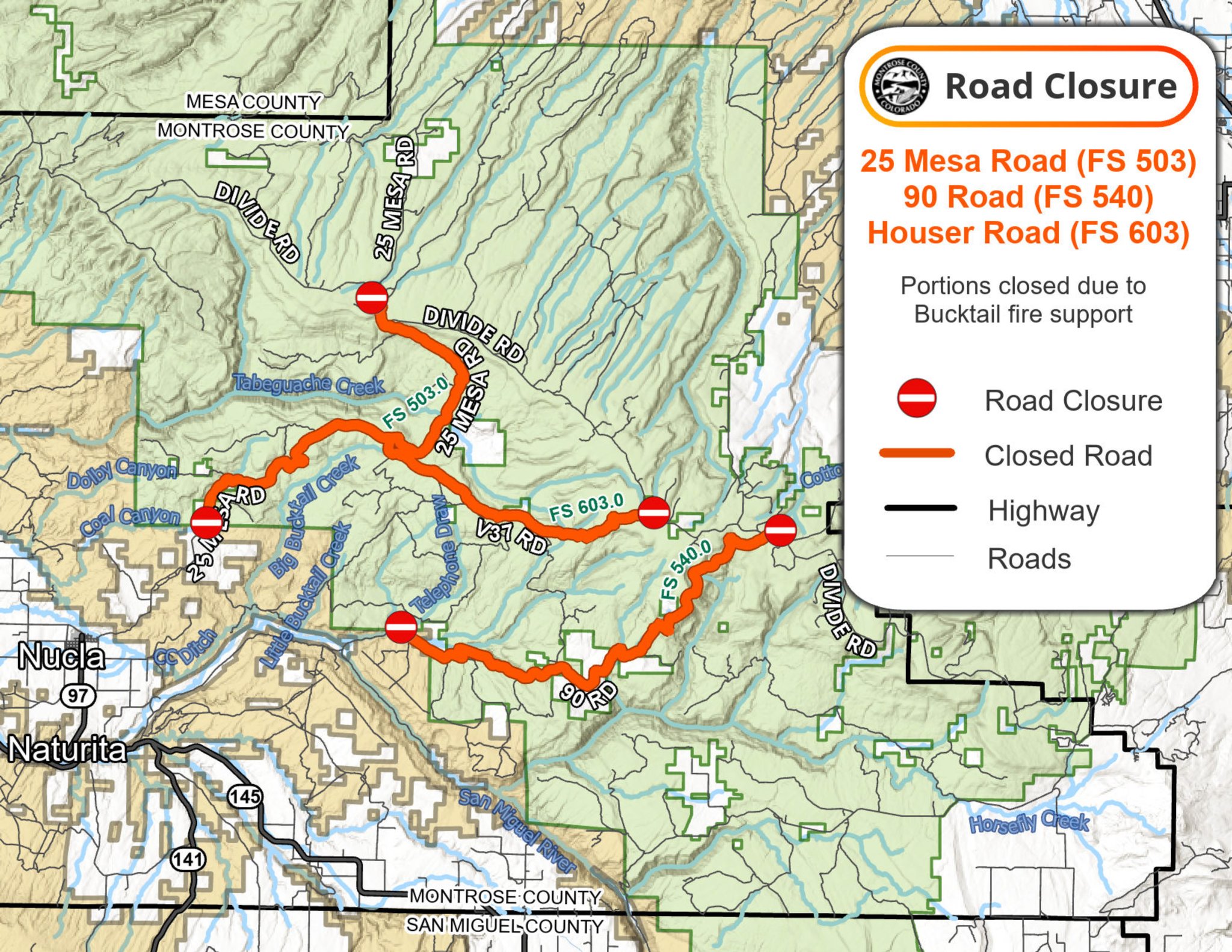
Road Closure Update 08 02 2024
Related Incident: Bucktail Fire
Publication Type: Closures
ROAD CLOSURE ALERT
Houser Cow Camp Road (Forest Service 508) extending down to Old Highway 90 is closed due to the #BucktailFire.
------
25 Mesa road is closed due to emergency operations on the Bucktail Fire. The closure extends from the 25Mesa/Divide Road intersection to where the pavement starts on 25 Mesa outside of Nucla.
Please avoid the area and do not fly drones.
If you have questions, please call the Bucktail Fire Information Line at (970) 823-4060
-Montrose County Sheriff's Office
See attached map for details.
Whisky Creek Fire Daily Update Actualizacin diaria del incendio Whisky Creek 08 02 2024
Related Incident: Whisky Creek Fire
Publication Type: News
Size / Tamaño: 934 acres
Start Date / Fecha de inicio: July 20, 2024 / 20 de julio de 2024
Cause / Causa: Human – Under Investigation / Humana, a ser determinada
Location / Ubicación: 6 miles SE of Cascade Locks, OR / 6 millas al SE de Cascade Locks, OR
Containment / Contención: 0%
Fuels / Combustibles: Scrub oak, timber, and grass / Arbustos de roble, restos de madera y césped
Total Personnel / Personal total: : 339
Highlights / Aspectos destacados:
Hot and dry weather yesterday further dried out forest floor fuels and led to a slight increase in fire activity. A helicopter was used to drop water along the northern edge of the fire to mitigate any potential flare-ups along the 2017 Eagle Creek Fire area while crews continued work on containment lines to the south. Growth on the fire has been along the western slope of Wooly Horn Ridge and to the south. A community meeting will be held to provide a fire update on Friday, August 2, at 7 P.M. at the Odell Fire Department, 3431 Odell Hwy., Hood River, OR.
Los combustibles del suelo forestal se secaron aún más debido al clima caliente y seco de ayer lo que provocó un pequeño aumento en la actividad de los incendios. Un helicóptero vertió agua a lo largo del extremo norte del incendio para reducir cualquier posible reavivamiento a lo largo del área del incendio Eagle Creek de 2017 mientras que las cuadrillas siguieron trabajando en las líneas de contención al sur. El crecimiento ha resultado a lo largo de la ladera oeste de Wooly Horn Ridge y hacia el sur. Se llevará a cabo una reunión comunitaria para brindar una actualización del incendio el viernes 2 de agosto a las 7 p.m. en el Departamento de bomberos de Odell, 3431 Odell Hwy., Hood River, OR.
Operations / Operaciones:
Indirect containment lines continue to be strengthened to the east, south, and west of the fire, using existing roads, trails, terrain features, and the Eagle Creek Fire burn area, with an emphasis on evacuation routes for firefighter safety and medical team access. Masticators and a skid steer continue to strengthen fire breaks along the southern wilderness boundary. Smoke is expected to be visible from Hood River and the communities along the Oregon Route 35 corridor. Fire managers are watching for opportunities to conduct tactical firing operations to remove potential fire fuels and limit fire spread.
Se siguen fortaleciendo las líneas de contención indirecta hacia el este, sur y oeste del incendio, con el uso de caminos existentes, senderos, características del terreno y el área quemada por el incendio Eagle Creek, con un énfasis en las rutas de evacuación para la seguridad de los bomberos y el acceso del equipo médico. Trituradoras y un tractor siguen reforzando los cortafuegos a lo largo del extremo sur del área de la naturaleza. Espera ver humo desde el río Hood y las comunidades a lo largo del corredor de la Ruta 35 de Oregón. Los encargados del incendio están atentos a cualquier oportunidad para llevar a cabo operaciones de quema táctica para eliminar los posibles combustibles del fuego y limitar la propagación del fuego.
Fire Behavior and Weather / Clima e intensidad del incendio:
Hot, dry weather with good overnight humidity recoveries is expected to persist through the weekend, with a slight chance of thunderstorms Friday through Sunday. Fire activity and smoke production is anticipated to increase with these weather conditions.
Se espera que el clima caliente y seco con buena recuperación de humedad por la noche persista el fin de semana, con una posibilidad pequeña de tormentas eléctricas de viernes a domingo. Se prevé que aumenten la actividad de los incendios y el humo con estas condiciones climáticas.
Road and Trail Closures / Caminos y vías cerrados:
The Mt. Hood National Forest and the Columbia River Gorge National Scenic Area closure information can be found at: Whisky Creek Fire Closures in Mark O. Hatfield Wilderness. Hood River County has closure information can be found on their website.
Información sobre el cierre del Bosque Nacional Mt. Hood y el Área Escénica Nacional del Río Columbia se puede encontrar en: Cierres por el incendio Whisky Creek en los espacios naturales de Mark O. Hatfield. El condado de Hood River tiene información sobre los cierres en sus páginas web.
Total Fire Resources Assigned / Total de recursos asignados al incendio:
• Approx. 339 personnel/personal, 9 hand crews/equipos de obreros, 5 water tenders/tanques de agua, 3 dozers/topadoras, 5 masticators/trituradoras, 1 skid steer/tractor, and 1 helicopter/helicóptero.
Contact Information / Información de contacto:
Email / Correo electrónico: 2024.whiskycreek@firenet.gov
Phone / Teléfono: 541-208-1743 8 A.M - 8 P.M
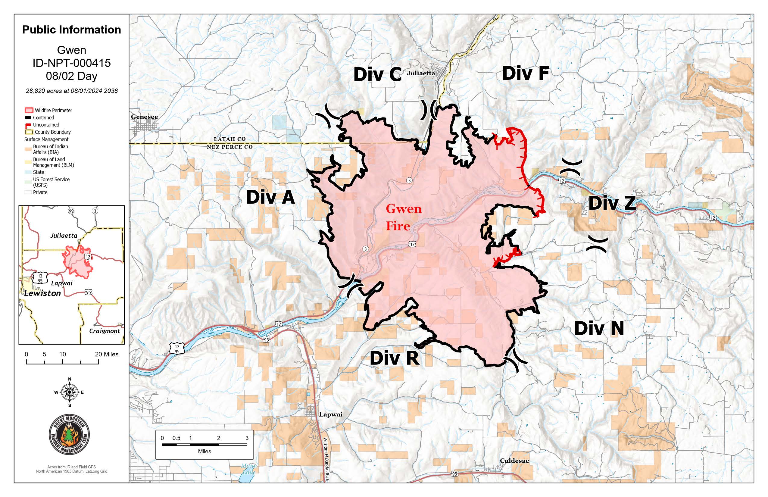
Gwen Fire Daily Update 08 02 2024
Related Incident: 2024 Gwen Fire
Publication Type: News
Rocky Mountain Complex Incident Management Team Three
Bill Waln, Incident Commander
Location: 5 miles east of Lapwai, Idaho Date Reported: July 24, 2024 Cause: Lightning
Size: 28,410 acres Containment: 85% Total Personnel: 242
RM CIMT Team Three will transfer command to a local Type 4 incident command tomorrow (Saturday, August 3, 2024) evening at 6:00 p.m. Firefighting resources will remain to continue mop up and patrol operations.
Expect to see isolated smoke in interior pockets as fuels smolder over the next several weeks. Occasional flare ups may occur and be visible until fuels are fully consumed. These sites are in steep areas with difficult access, or they are surrounded by previously burned material. They have been thoroughly evaluated and do not pose a threat.
Current Situation: (Refer to the map for Division locations)
- NIROPS (National Infrared Operations), used infrared equipped aircraft to survey the fire last night. The data was consistent with known hotspots, none of which pose a concern or threat.
- Isolated and scarce areas of heat remain, primarily near the Division F- Z break along highway 12. They will be visible and produce smoke until fuels are fully consumed.
- An Extreme Heat Warning is in effect. Firefighters could experience temperatures of up to 112 degrees in canyons where radiant heat is trapped. This is actually a benefit to firefighters in that any remaining hot spots will become more active allowing firefighters to mop them up.
- Today, crews from Rocky Mountain Incident Management Team Three will continue to monitor and secure the fire perimeter and road corridors in preparation for a transfer of command.
- The incident management team has been working closely with local resources and agencies throughout the incident. The team will leave resources in place to ensure a smooth and safe transition.
Please continue to check with your local Sheriff’s Office. Fire hazards are still a possibility in these areas.
- Latah County Sheriff’s Office: (208) 882-2216
Facebook: https://www.facebook.com/LatahCountySO - Nez Perce County Sheriff’s Office:
Facebook: https://www.facebook.com/NezPerceCountySheriffsOffice. - Nez Perce County Emergency Management Interactive Evacuation Map: https://bit.ly/3yewVv0
Air Quality Information: Please visit https://fire.airnow.gov/ for resources on smoke and air quality. Air quality monitors indicate unhealthy for sensitive groups in the Lapwai area.
Weather and Fire Behavior: An Extreme Heat Warning is in effect, with temperatures in excess of 110 degrees forecasted. Winds out of the east will be steady at 8 mph with gusts to 15 mph. Minimum humidity around 13 percent.
Closures: All roads and highways are open to the public. Hazards remain along the highway, please use extreme caution when traveling in and around the fire area.
GWEN FIRE INFORMATION
Fire Information Phoneline: (208) 843-3534 (Time: 7am-7pm) Email: 2024.Gwen@firenet.gov
Facebook: @IdahoDepartmentofLands InciWeb: inciweb.wildfire.gov/incident-information/idids-2024-gwen-fire