
Alexander Mountain Fire Daily Update 08 02 2024
Related Incident:
Publication Type: Announcement
Alexander Fire Daily Update August 2, 2024 by Southwest Area Incident Management Team 1
Acres: 9,375
Start Date: 07/29/24
Location: Larimer County, Colorado
Personnel: 389
Containment: 5%
Highlights: Temperatures and topography challenged crews as they continued work to secure the perimeter of the fire today. Fire crews completed a successful burnout near Cedar Springs Reservoir and focused efforts along Highway 34 and the eastern perimeter of the fire to ensure the line is holding. Aircraft continued to drop water and retardant on the western flank of the fire to slow the spread. The public is asked to avoid the fire area and abide by any posted signage and restrictions. The cause of the fire is under investigation.
Fire Activity: Fire activity increased in the northwest portion of the fire today and south of Snowtop Drive, above Highway 34. Smoke visibility increased in the afternoon.
Weather: Saturday is expected to remain hot and dry. Rising humidity and passing disturbances will increase the chance for thunderstorm development. Incoming storms could bring dry, gusty, and erratic winds. Thunderstorm potential decreases Saturday with hit or miss rain returning Sunday. Any of these storms may produce heavy winds and rainfall.
Smoke: Heavy smoke has impacted communities in the immediate vicinity of active fire, including Glen Haven and other high elevation neighborhoods north of Estes Park. Overnight, heaviest impacts will be in western Loveland and areas immediately downstream of the fire. An Air Quality Advisory for Multiple Pollutants has been issued for southeastern Larimer and northeastern Boulder counties.
Closures, Evacuations and Structure Assessment: The Larimer County Sheriff’s Office Joint Information Center is providing information about evacuation notices, animal evacuations and road closures. For evacuation information visit nocoalert.org or text LCEVAC to 888777. The Joint Information Center can be reached at
970-980-2500. If you believe your property may be impacted by the Alexander Mountain Fire, please call the Damage Assessment Center at 970-980-2800 to provide current contact information to the Office of Emergency Management.
The Forest Service implemented Stage 2 fire restrictions today. Refer to the Arapaho and Roosevelt National Forests website for more information.
Fire Cause: The cause of the Alexander Mountain Fire is under investigation. Anyone with information regarding the cause and origin of the Alexander Mountain fire is asked to call the Forest Service Law Enforcement Tip Line at 303-275-5266. Photographs and videos can be submitted via https://fs.us.evidence.com/axon/community-request/public/amountainfire.
More Information:
Email: To receive email updates on this fire, join our email list and select Forest Health & Fire: North of Hwy 34 to Hwy 14 (Buckhorn Canyon, Glen Haven, Cedar Park).
Facebook: https://www.facebook.com/AlexanderMountainFire
Inciweb: https://inciweb.wildfire.gov/incident-information/coarf-alexander-mtn-fire
Bluff Creek Complex Daily Update 08 02 2024
Related Incident:
Publication Type: News
Bluff Creek Complex
Idaho Panhandle National Forests
Fire Information 208-557-8813
https://inciweb.wildfire.gov/incident-information/idipf-bluff-creek-complex
August 2, 2024
Idaho Panhandle Type 3 Incident Management Team
Incident Commander Brian Hicks and Incident Commander Trainee Bryce Barth
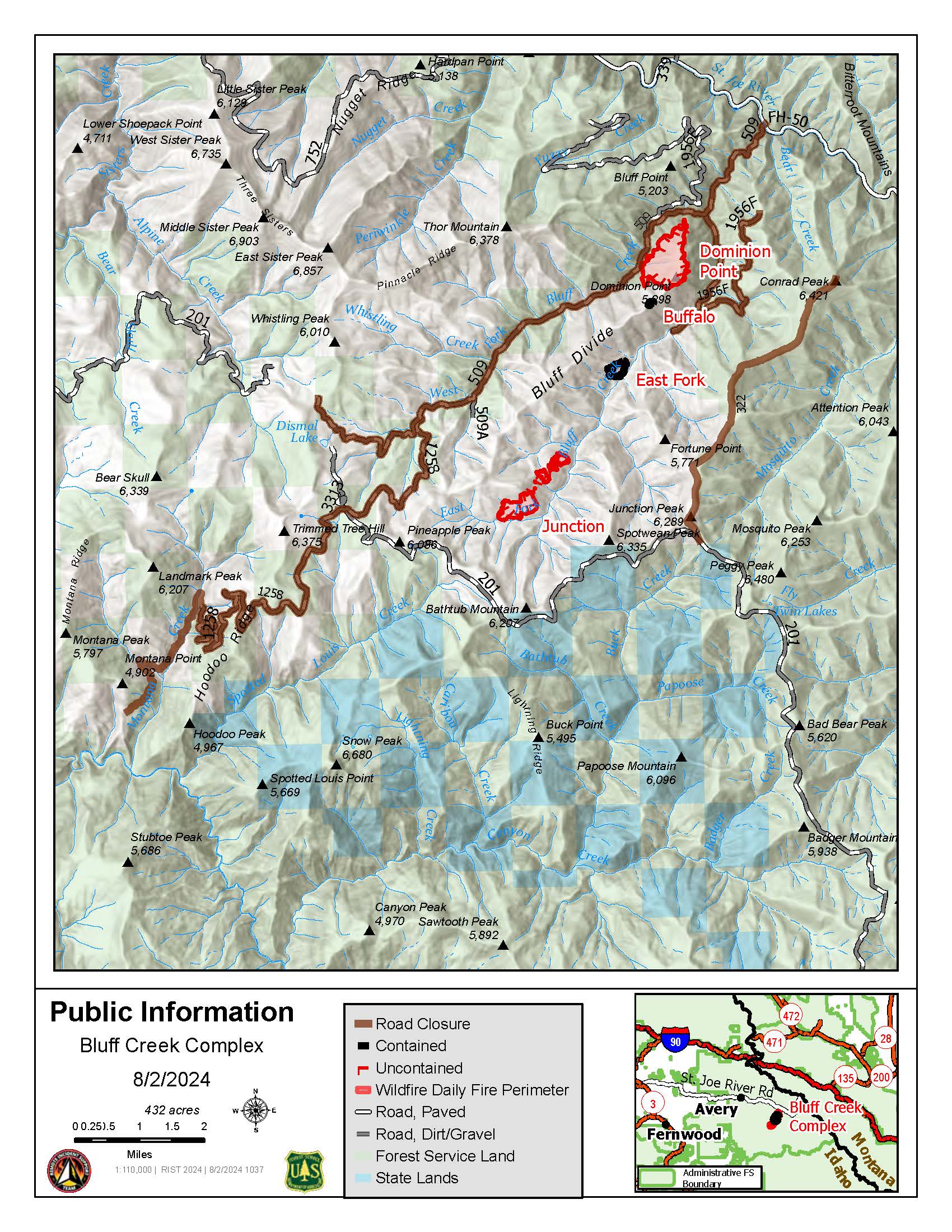
Location: The fires are burning along both sides of the Bluff Divide, approximately 13 1/2 miles southeast of Avery, ID; five and a half miles west of Gold Creek Campground; and approximately two miles northwest of Junction Ridge.
Start Date: 7/25/2024 Cause: Lightning Size: 432 acres
193 Total Personnel:
5 Engines
4 Type 2 Hand Crews
2 Interagency Hotshot Crews
6 Heavy Equipment
4 Water Tenders
Key Message:
Updates will occur when conditions warrant, such as changes in acreage or containment.
Current Status:
The Bluff Creek Complex consists of four different fires: Junction Fire, East Fork Fire, Dominion Point Fire, and Buffalo Fire. The Dominion Point Fire held at 275 acres; the Junction Fire is 60% contained and 130 acres; the East Fork Fire is 80% contained and 25 acres; and the Buffalo Fire is 100% contained at 2 acres. An infrared flight in the early hours of August 1st resulted in a reduction in acreage due to more precise mapping. All available resources are engaged in suppression, working on these fires based on priority order. Due to the threat to values at risk, including private industry timberlands, active logging sales, and equipment, the Junction Fire and the East Fork Fire remain priority, but work continues on Dominion Point as well.
Approximately 1” of rain was received across the Fire Complex on July 30th, greatly moderating fire behavior and providing an opportunity for firefighters to increase containment. Much of the fireline (constructed with hand tools, heavy equipment, or reinforced roads) is now plumbed, meaning hoses are set up to aid firefighters in holding these lines.
WEATHER
Temperatures have increased again with 96-104 degrees in the valleys and 87-97 in the mountains. Relative Humidity decreased, ranging from 16%-26%. Temperatures will stay elevated through the weekend, with possible thunderstorms on Sunday.
Closures and Special Messages
Closure orders are in place to protect the safety and welfare of the public and provide for safe firefighting efforts and access. Specific closure information and maps are posted on InciWeb at https://inciweb.wildfire.gov/incident-closures/idipf-bluff-creek-complex and https://www.fs.usda.gov/alerts/ipnf/alerts-notices as they are implemented.
The Bluff Creek Complex closures include the following roads and area:
- CLOSED:
- Order Number: # 01-04-04-24-005 (Bluff Creek Fire Road Closure)
- Forest Development Road 509 beginning at its junction with County Highway 50 and concluding at its intersection with Forest Development Road 201.
- Forest Development Road 1258 beginning at its junction with Forest Development Road 509 concluding at its intersection with Forest Development Road 201.
- Forest Service Development Road 1956F beginning at its junction with Forest Development Road 509 and concluding at its unction with Forest Development Road 3338.
- Forest Development Road 322 beginning at its junction with Forest Development Road 201 concluding at Conrad Peak.
- Order Number: # 01-04-04-24-006 (Gold Flat Area Closure): Gold Flat undeveloped campsite located 8.6 miles North on Forest Development Road 218 from Red Ives Cabin. Gold Flat undeveloped campsite is located within Section 23 and 24 in T16N, R30W. The area Gold Flat undeveloped campsite comprises approximately 6.2 acres bordered by the St. Joe River on the West and Forest Development Road 218 on the East.
- Order Number: # 01-04-04-24-005 (Bluff Creek Fire Road Closure)
At this time, a TEMPORARY FLIGHT RESTRICTION is in place for 27NM SE KELLOGG, Idaho near MULLAN PASS VOR/DME (MLP). No pilots may operate an aircraft in the areas covered, including drone pilots.
News Release Pleasant Valley Fire 08 02 2024
Related Incident: Pleasant Valley Fire
Publication Type: News
Daily Update on Pleasant Valley Fire 08 01 2024
Related Incident: Pleasant Valley Fire
Publication Type: News
Fire Update 08 02 2024
Related Incident: Currant Creek Fire
Publication Type: News
August 2, 2024
Size: 193 acres Containment: 75%
Division supervisors confirmed Friday that approximately 75% of the Currant Creek fire perimeter is now contained. Crews will continue working to secure the remaining open perimeter Friday afternoon and through the weekend. Resources no longer needed on this fire have been released so they can help on other fires throughout the region. 62 personnel and a helicopter remain committed to the Currant Creek Fire. This afternoon, the area received light rain.
After consulting with fire managers and partner agencies, Delta County Sheriff Mark Taylor has announced he will be rescinding the evacuation order for residents on Currant Creek Road who live within the fire perimeter and north of the fire area, effective Sunday, August 4th at 8:00 a.m. Affected residents and property owners will be able to return to their homes and properties after that time.
However, firefighters will still be working in the area and use of Currant Creek Road will continue to be limited to residents and property owners only. The access road is a narrow, single-lane, unimproved road and there are few opportunities for vehicles to pass one another. For firefighter and public safety, this road must remain clear.
Preparedness: New fire starts can quickly grow into an out-of-control fire that threatens private property and homes as evidenced by multiple large, rapidly-growing wildfires in Colorado just this week. Delta County Emergency Management encourages all residents of Delta County to opt-in for emergency alerts via the Delta County Alerts system. In an emergency, critical safety alerts and evacuation notices are issued via Delta County Alerts.
Be sure you and your family are registered to receive Emergency Alerts by visiting the Delta County Alerts website and registering today! Residents who do not wish to share personal information or who need alert information translated into a language other than English, are encouraged to download the ReachWell app and follow Delta County Alerts. The app will deliver all emergency alerts the County issues to you in your preferred language of choice (including English). Regardless the method you prefer to receive alerts, everyone is encouraged to opt-into emergency alerts!
Closures: Currant Creek Road will be re-open to local residents only beginning at 8:00 a.m. Sunday, August 4, 2024. Non-residents should continue to avoid the area.
Park Fire Temporary Closures on Federal Lands 08 02 2024
Related Incident: Park Fire
Publication Type: Closures
While the majority of the Park Fire is on non-federal property, portions of nearby federal lands have been affected, prompting temporary closures. These closures are in place to protect public safety and support firefighting efforts.
Conditions are changing rapidly. Smoke and fire conditions pose serious risks to public health and safety. It’s essential to obey all closure orders and avoid affected areas.
For the latest information on the fire and closures, check the websites of relevant federal agencies and local authorities.
Please prioritize your safety and follow the guidance of local officials.
See attachments for the BLM, National Park Service, and Forest Service closures.
For more information on the #ParkFire please visit:
CALFIRE Park Fire: https://www.fire.ca.gov/incidents/2024/7/24/park-fire
Butte County Sheriff: https://www.facebook.com/bcsonews
CAL FIRE Tehama-Glenn Unit/ Tehama County Fire Department: https://www.facebook.com/CALFIRETGU
CAL FIRE Shasta-Trinity Unit/Shasta County Fire Department: https://www.facebook.com/CALFIRESHU
Butte County, CA: https://www.facebook.com/ButteCounty
August 2 2024 Bucktail Fire update 08 02 2024
Related Incident: Bucktail Fire
Publication Type: News
NEWS RELEASE
For Immediate Release
Media Contact:
Public Information Officer, 970-823-4060
2:00 p.m. Fire Update - Bucktail
Nucla, Colorado, August 2, 2024
Name: Bucktail
Location: Approximately six miles northeast of Nucla, CO
Size: Approximately 2,046 acres (MMA mapped. Note - acreage on map is from last night)
Cause: Unknown
Jurisdiction: Colorado Division of Fire Prevention and Control (DFPC), Bureau of Land Management (BLM) and United States Forest Service (USFS).
Containment: 0%
Threatened Structures: 0
Resources: 5 engines, dozers, 3 crews, Montrose Helitack
The Bucktail exhibited active fire behavior throughout the night. The fire is moving upslope in mesa and canyon country. The priority is fire-fighter safety.
Smoke may be visible in the area for the next several days. Zero structures are threatened. The County Road 25 Mesa is now closed due to emergency operations on the Bucktail Fire. The closure extends from the 25 Mesa/Divide Road intersection to where the pavement starts on 25 Mesa outside of Nucla. Houser Cow Camp Road is closed, down to Old Highway 90 (https://www.facebook.com/MontroseCountySO). In the interest of public safety, fire officials ask visitors to be aware of fire traffic and avoid the area. Firefighter and public safety are the priorities for this incident.
Fire managers would like to remind forest users to continue to be attentive of their actions and surroundings, especially in areas with dry vegetation or dead/down trees. Practice smart wildfire prevention behavior, including never leaving a campfire unattended, using established campfire rings, picking safe and proper campfire sites, and ensuring that their fires are completely out and cool to the touch by using the drown, stir and feel method.
For additional information:
Colorado Division of Fire Prevention and Control: https://dfpc.colorado.gov
Bureau of Land Management Southwest Colorado District, Uncompahgre Field Office: https://www.facebook.com/BLMMontroseFireUnit
West Slope Fire Information website: www.WestSlopeFireInfo.com
Bucktail Fire Information Hotline: (970) 823-4060
Evacuation Update Retreat Fire 08 02 2024
Related Incident: Retreat
Publication Type: Announcement
08/02/24 Retreat Fire UPDATE from Yakima Valley Emergency Management
The US 12 Freeway Corridor from the "Y" at Naches to Hause Creek remains at a LEVEL 3 evacuation.
The Tieton/Cowiche area is now downgraded to a LEVEL 1 evacuation.
The Highway 12 corridor remains closed to public transportation for both firefighters and public safety. Affected by the fire, large trees have been falling over the road at unexpected times and fire crews and crews continue to work at various locations. The road is expected to remain closed for several more days.
Ore Fire Update 08 02 2024
Related Incident: Ore Fire
Publication Type: News
Fire Update – Ore Fire
Friday, August 2, 2024 – 9:30 a.m.
Size: 1539 acres | Reported Date: July 16, 2024 | Cause: Under Investigation | Containment: 29%
Total Assigned Personnel: 218
The Rocky Mountain Complex Incident Management Team 1 (CIMT1) has now assumed command of the Ore Fire. Due to the limited availability of additional incident management teams in the region, all fires on the Willamette National Forest are being combined under a central command structure. While the incident command post for the fire has been relocated, crews and equipment for the Ore Fire will continue to operate out of Strube Flats.
Yesterday, firefighters continued to mop up and patrol the fire perimeter along the FS 1509 and FS 15 Roads. Hose lays and sprinklers were repositioned from areas of containment to more active areas of the fire. Heavy equipment operators completed a check line connecting the FS 502 Road to the FS 15 Road, adding another containment line on the northeast end of the fire. Nonessential equipment along containment lines was backhauled to Strube Flats to be cleaned and readied for future assignments.
Today, line construction to the north continues, using a combination of existing roadways, handline and dozer lines. Chipping of removed woody debris and other fuel mitigation efforts are ongoing along the roadways. Firefighters working on day and night shifts will continue to hold the fire perimeter to the south, preventing fire spread into critical infrastructure and identified values at risk.
A helicopter landing zone was created on the north end of the fire where access to provide emergency extractions would be limited in the case of an emergency.
Weather and Fire Behavior:
Warm and dry weather is expected today; however, it will be cooler than yesterday. Moderate fire behavior may be observed in areas where slope, wind, and proper fuel types align. A strong inversion is in place with warmer and drier conditions existing at higher elevations. Evening downslope and down valley winds will be present once the sun sets. A stray dry thunderstorm cannot be ruled out over the fire area.
Closures and Fire Restrictions:
Area, road, trail, and recreation site closures are in place on the Willamette National Forest in the vicinity of many active fires. Temporary road barricades are in place to restrict traffic across the fire areas. For specific closure information follow this link:
https://www.fs.usda.gov/detail/willamette/alerts-notices/?cid=fseprd552029
Fire restrictions on the Willamette National Forest may be found at this link: https://www.fs.usda.gov/alerts/willamette/alerts-notices/?aid=81487
Temporary Flight Restrictions (TFR) remain in place over the Ore Fire. Wildfires are a no-fly zone for unauthorized aircraft, including drones. If you fly, we can’t. For more information, visit http://knowbeforeyoufly.org.
Falls and Telephone Fires Information Update 08 02 2024
Related Incident: Telephone Fire
Publication Type: News
Falls and Telephone Fires Update for Aug 2, 2024
Telephone Fire Quick Facts:
Size: 46,000 Start Date: July 22, 2024 Location: 12 miles NE of Burns, OR
Containment: 23%. Total Personnel: 353 personnel Cause: Lightning/Natural
Resources Assigned: 11 hand crews, 20 engines, 6 bulldozers, 7 water tenders, 4 skidders
Falls Fire Quick Facts:
Size: 143,236 Start Date: July 10, 2024 Location: 13 Miles NW of Burns, OR
Containment: 73% Total Personnel: 542 Cause: Human-caused, under investigation
Structures Triaged: Residences: 386; Commercial: 119 Outbuildings: 760
Resources Assigned: 29 hand crews, 44 engines, 14 bulldozers, 24 water tenders, 7 masticators, 8 skidders
Sand Mountain Fire Quick Facts:
Size: 4,974 Start Date: July 25, 2024 Location: 17 miles SW of Seneca, OR
Containment: 0% Total Personnel: Staffed by Falls Fire personnel Cause: Lightning/Natural
Ritter Fire Quick Facts:
Size: 459 Start Date: July 23, 2024 Location: Stinking Water Mountain NE of Crane, OR
Containment: 100%. Total Personnel: 6 personnel Cause: Lightning/Natural
Other Fires Quick Facts:
Whiskey Mountain: 4,345 acres; Cow Creek: 86 acres; Parasol: 485 acres; Poison: 1,011 acres.
Total Personnel: Staffed by Falls Fire personnel.
The National Weather Service has issued a Red Flag Warning (in effect through 8/3 at 11:00pm) and Excessive Heat Warning (in effect through 8/2 at 11:00 pm) for the fire area.
Aerial resources assigned: 2 Type 1 helicopters and One Type 1 Uncrewed Aircraft System (UAS) assigned and available to all fires in the area. Air support also includes a lend/leasing system and additional aircraft will be pulled from different areas of the region to our fires today.
Crews are working 24/7 towards reaching priorities on area fires. Day shift, swing shift, and night shift crews’ work is highly coordinated to benefit suppression efforts. Shifts intentionally overlap during the critical burn period, and night shift firefighters work in the highest priority areas and places with imminent effects and concerns.
Community Meetings Scheduled:
Friday, August 2 at 3 pm, at Seneca City Hall, 106 Avenue A, Seneca OR
Leaders of the Alaska Incident Management Team will be in Seneca for a community meeting to provide an update on the Telephone Fire, Falls Fire and several other fires we are working to suppress in the area. The meeting will also be shared on the Malheur National Forest Facebook page, as well as the Falls and Telephone Fires Facebook page.
Priorities for Friday, August 2:
*Weather and fuel conditions are in alignment for extreme fire behavior today.
- Initial Attack: The potential for new fire starts in the area remains significant at this time, and firefighters remain vigilant and focused on initial attack (IA) and are ready to respond to any new threats.
- Identify direct and indirect control line options on the northwest portion of the Falls and Sand fires to stop westward fire progression and hold existing direct firelines.
- Work to gain containment around yesterday’s slopover on the southwest side of the Telephone Fire
- Continue work towards tying into the Pine Creek drainage on the Telephone Fire
- Continue to secure line on the Poison Fire, conduct mop up in areas of recent small-scale firing operations
Fire Summaries:
Hotter and drier weather occurring over the next several days could lead to increased fire behavior and will test existing firelines. Fire plumes could be visible over parts of the fire areas today.
Telephone Fire: The northwest and northeast sides of the Telephone Fire were very active on Thursday and increased in size by approximately 7,000 acres. Most growth was interior in the northeast corner. In mid-afternoon, the fire crossed over the 2820 road on the northwest side of the fire, about halfway between the 28 road and East Mill Creek Road. It pushed toward King Mountain with roughly 1,000 acres of growth to the northwest; Harney County Sherriff’s office made evacuation notifications to the Trout Creek area. On the northeastern perimeter the fire was actively burning interior of control lines 1.5 miles northeast of Elephant Butte. It was influenced by light southeasterly winds and hot, dry, and unstable conditions. Very large air tankers (VLATs) and helicopters responded on the east side of the fire. Crews with engines and a dozer worked the edge of the fire, and more resources are being mobilized to join the effort. Firefighters on the ground continue working to minimize the fire’s advances, with crews in the area repositioning and additional crews mobilizing to join the effort.
Yesterday afternoon, Oregon Governor Tina Kotek invoked the Emergency Conflagration Act for the Telephone Fire which allowed the Oregon State Fire Marshal (OSFM) to mobilize four structural task forces and its OSFM Green incident management team to protect homes and critical infrastructure under threat from the fire. One task force went straight to work on the fire last night. The other three task forces will be deployed this morning protecting homes and critical resources on the western and northern flank of the fire. The OSFM team will be in Unified Command with Alaska Incident Management Team 1, working shoulder to shoulder towards reducing risk to nearby communities. Fire crews on Falls and other area fires continue structure protection in any critical areas as needed.
Today, In the Poujade area, Oregon National Guard crews are mopping up in the area of recent small-scale ignition operations. Crews will continue small-scale firing operations along dozer lines on the northeast side of the fire and reinforcing line on the east side to mitigate spread. On the east side, crews will go direct, tying hand lines into dozer lines to anchor in the line. Aerial resources will assist on the Telephone Fire, including our two assigned helicopters and other local lend-lease aircraft, and will use retardant when possible to slow fire spread.
Falls Fire:
Fire pushed north on Thursday and merged with the Sand Fire but is still well within the 31 Road contingency line. Yesterday the Falls Fire had a westward slopover of approximately 800 to 1,000 acres near Gilbert Ridge; crews are directly engaging this area today with dozers and air support. Additionally on Thursday, a slopover occurred in the Whiskey Mountain Fire area. The night shift was able to tie it back into control line, and crews will work to identify all potential heat in the area today and will increase containment depth with mop up operations. South of Myrtle Creek, line continues to hold well and crews are gaining depth within the containment line and address any green islands of vegetation. Line is fully complete around the northeast corner of the Falls fire, with the objective to protect Seneca, Silvies Ranch, and the 395 corridor. Thursday’s active fire behavior was a good test of fire line on the south and east sides of the fire, which held.
Sand Mountain Fire:
Firefighters continue work to improve line around Smokey Creek on the northwest side of the fire as well as dozer line to connect to the 31 road to use as indirect line. On Thursday, small-scale ignition operations were conducted on the northwest side of the Sand Fire. Today, dozer line work will continue, and the Arrowhead Hotshots will do small-scale firing ignitions across Gilbert Ridge, continuing work to tie in line to link the Sand and Falls fires. Crews will strengthen and improve fire line along the north and west flanks of the fire, patrol, and mop up.
Parasol and Poison Fires: The Parasol is completely surrounded with line, and is now in monitor status with light engine presence. The Poison Fire is moving into the mop up and gridding stage; crews are working to gain depth inside the fire line.
Ritter Fire: 100% containment has been reached on the Ritter fire, and it is now in monitor status. The fire camp for the Ritter fire closed on Thursday. Several engines will continue monitoring the area to ensure nothing rekindles during the upcoming time of extreme fire weather.
Weather: Critical fire weather will be in the area Friday and Saturday, bringing extreme heat and likely increased fire behavior. Conditions will be supportive to large fire growth and a Red Flag Warning is in effect for today. Winds will be from the south/southwest around 12 mph with gusts up to 18 mph, and high temp up to 102 degrees, with relative humidity at 8-15%. Smoke from the Park Fire in northern California is expected to sit over our area today. Two additional Incident Remote Automated Weather Systems (IRAWS) have been deployed, one by Van and one by Calamity Butte.
Evacuations: The Telephone Fire is pushing toward King Mountain and notifications have been made to the Trout Creek area, which remains in a LEVEL 3 evacuation zone. For the most accurate evacuation information, please visit the Harney County Sheriff’s evacuation map here: https://tinyurl.com/3zst4sjy, or the Grant County Emergency Management Facebook page: https://www.facebook.com/profile.php?id=100068819321423.
Closures: The Malheur National Forest has issued the new Courtrock Fire Area closure on the Blue Mountain Ranger District, due to fire activity and fire suppression operations. This closure is effective August 1, 2024 and rescinds and replaces the previous Temporary Forest Closure Order. The Closure Area includes the two portions of the Malheur National Forest that run west of 395B, north of Mt. Vernon and south of Long Creek, in the Fox Valley area, including all roads, trails, and camping locations within the fire closure area. A detailed map of the closure if included and available on the Malheur National Forest website (https://www.fs.usda.gov/malheur/) and offices.
Investigation: U.S. Forest Service fire investigators are seeking the public’s assistance with any tips or information pertinent to the start of the Falls Fire on the Malheur National Forest. Please submit any information that could assist fire investigation efforts to SM.FS.R6TipHotLine@usda.gov.
Temporary Flight Restriction (TFR): TFRs in the area have been changing; pilots should check the latest information on the Federal Aviation Administration TFR website prior to flying: https://tfr.faa.gov/tfr_map_ims/html/index.html
Facebook: https://www.facebook.com/p/Falls-Fire-2024-61562126623985/
Falls Fire InciWeb: https://inciweb.wildfire.gov/incident-information/ormaf-falls-fire
Telephone Fire InciWeb: https://inciweb.wildfire.gov/incident-information/ormaf-telephone-fire
Fire Information Line: 541-208-4370, staffed 8 a.m. to 8 p.m.
Email: 2024.Falls@firenet.gov
Harney County non-emergency evacuation questions: 541-589-5579
Air quality questions: 541-573-2271. Air quality information, searchable by zip code: https://fire.airnow.gov/
Smoke Outlooks: https://outlooks.airfire.org/outlook
Morning Operations Briefing for 8/2/24
https://www.facebook.com/61562126623985/videos/1555830588662590