
Actualizacin Jueves 5 de Noviembre
Related Incident:
Publication Type: News
Incendio Cameron Peak
Incendio East Troublesome Zona Thompson
Actualización – Jueves, 5 de Noviembre, 2020 @ 9:00 a.m.
Rob Allen, Comandante del Incidente
Información: 970-541-1008
Correo Electrónico: 2020.cameronpeak@firenet.gov
YouTube: www.youtube.com/channel/UCPNA6qSJC2UYKz68rp9etvA
Inciweb: https://inciweb.nwcg.gov/incident/6964/
Facebook: https://www.facebook.com/CameronPeakFire
Incendio Cameron Peak
Tamaño:208,913 acres
Contención: 92%
Reportado: Ago. 13, 2020
Causa: Bajo investigación
Personal Total: 1,103
Zona Thompson
Tamaño: 4,889 acres
Contención: 48%
Reportado: Oct. 22, 2020
Causa: Foco secundario
A lo largo de Cameron Peak y East Troublesome Zona Thompson, los bomberos siguen participando en el trabajo importante de liquidación, retroceso y reparación de supresión donde el acceso lo permite. En el fuego escapado del North Fork Trail, los bomberos trabajarán para liquidar y asegurar el borde del incendio. Aunque se puede ver algo de humo y fuego activo en algunas áreas, hay una baja probabilidad de que el fuego se comporte más allá de la quema de un solo árbol. La propagación en la superficie puede acelerarse moderadamente hoy debido a los vientos frontales del suroeste más fuertes antes de un frente frío que puede traer más humedad el domingo o el lunes.
En la Zona Thompson del Incendio East Troublesome, los equipos continúan trabajando para asegurar y contener el borde del fuego. Se están utilizando recursos aéreos para monitorear áreas de alta elevación con humo en la zona interior del incendio y tomar medidas de supresión de cualquier área hipertérmica cerca del perímetro si es necesario.
El equipo de mando de incidentes se ocupará de reparar los daños causados por las acciones de extinción de incendios en todos las tierras públicas y privadas. Este trabajo repara las líneas de mano y dozars, caminos, senderos, áreas de preparación, zonas de seguridad y descarga aérea utilizadas durante los esfuerzos contraincendios. Las actividades de reparación incluirán arrastrar bermas con la capa superior del suelo, hojarasca y tierra a través de las líneas de control con el objetivo de volver a cubrir la superficie con el material que se desplazó. Con el suelo compactado suelto y la capa superior del suelo reemplazada, el banco de semillas debe responder rápidamente a la precipitación. Si su terreno privado ha sido afectado por una acción de extinción contraincendios y no desea que se realice una reparación en su terreno, llame a la Oficina de Manejo de Emergencias del Condado de Larimer al 970-498-7120 o visite oem@larimer.org.
CIERRES: Las tierras del Bosque Nacional en el Distrito de Canyon Lake están cerradas.
Bosque Nacional de Arapahoe y Roosevelt: https://www.fs.usda.gov/alerts/arp/alerts-notices/
El Parque Nacional de Rocky Mountain está cerrado.
Parque Nacional de Rocky Mountain: https://www.nps.gov/romo/learn/fireinformation-and-regulations.htm
Condado de Larimer evacuaciones y el cierre de carreteras: https://nocoalert.org
RECURSOS: 2 equipos de tipo “hotshot”, 21 equipos de mano tipo 2, 62 camiones, 11 dozar, 7 helicópteros, y 14 camiones cisterna.
TIEMPO/CLIMA: Un sistema de alta presión se formará sobre la zona de incendio hoy, trayendo cielos despejados con condiciones más cálidas, secas y con vientos calmados. Otro sistema meteorológico comenzará a acercarse desde el oeste el viernes trayendo consigo condiciones un poco más cálidas y secas, pero vientos más altos. Esto continuará hasta el sábado con la posibilidad de lluvia por la noche con el potencial de convertirse a nieve y con temperaturas frías a principios de la próxima semana. Sin embargo, no se espera que las condiciones de viento cálido del viernes causasen un aumento evidente del comportamiento de incendio, sin embargo, la amenaza de que los árboles debilitados por el fuego caigan en los vientos fuertes sigue siendo un peligro para los bomberos y cualquier persona en la zona del incendio. Para obtener información sobre el humo y la calidad del aire, visite: https://www.colorado.gov/airquality/colo_smoke.aspx
Restricción temporal de vuelo (RTV): Hay un RTV sobre el incendio de Cameron Peak. Los incendios forestales son una zona prohibida para los drones. Si usted vuela, nosotros no podemos. Siempre que se detecta un dron cerca del fuego, ningún avión puede volar hasta que podamos estar seguros de que el dron está fuera del área. Para obtener más información, visite http://knowbeforeyoufly.org.
Cameron Peak Fire Information Update Thur Nov 5
Related Incident:
Publication Type: News
Cameron Peak Fire
East Troublesome Fire Thompson Zone
Update – Thursday, November 5, 2020 @ 9:00 a.m.
Rob Allen, Incident Commander
Fire Information: 970-541-1008
Email: 2020.cameronpeak@firenet.gov
YouTube: www.youtube.com/channel/UCPNA6qSJC2UYKz68rp9etvA
InciWeb: https://inciweb.nwcg.gov/incident/6964/
Facebook: https://www.facebook.com/CameronPeakFire
Cameron Peak Fire
Size: 208,913 acres
Containment: 92%
Start Date: Aug. 13, 2020
Cause: Under Investigation
Thompson Zone
Size: 4,889 acres
Containment: 48%
Start Date: Oct. 22, 2020
Cause: Spot Fire
Total Personnel: 1,103
Across both the Cameron Peak and Thompson Zone of the East Troublesome Fires, firefighters remain engaged in the important work of mop-up, backhaul and suppression repair where access allows. On the North Fork Trail slop-over, firefighters will work to mop-up and secure the fire’s edge. Although some smoke and active fire is visible in a few areas, there is a low probability of fire behavior beyond single tree torching. Surface spread may accelerate moderately today due to stronger southwest frontal winds ahead of a cold front that may bring more moisture Sunday or Monday.
In the Thompson Zone of the East Troublesome Fire, crews continue work to secure and contain the fire edge. Aviation resources are being used to monitor high elevation areas of smoke in the interior of the burn and take suppression action on any heat near the perimeter if necessary.
The Incident Management Team will engage in repairing damage caused by fire suppression actions on all public and private lands. This work repairs the hand and dozer lines, roads, trails, staging areas, safety zones, and drop points used during fire suppression efforts. The repair activities will include pulling berms with topsoil, litter, and duff back across control lines with the goal of re-covering the surface with the material that was removed. With the compacted soil loosed, and the removed topsoil replaced, the seedbank should respond quickly to precipitation. If your private land has been disturbed by suppression action and you don't do not wish to have repair done on your land, call Larimer County Office of Emergency Management at 970-498-7120 or visit oem@larimer.org.
CLOSURES: National Forest System lands on the Canyon Lakes Ranger District are closed.
Arapaho and Roosevelt National Forests closures: https://www.fs.usda.gov/arp/alerts-notices/
Rocky Mountain National Park is closed.
Rocky Mountain National Park closures: https://www.nps.gov/romo/learn/fire-information-and-regulations.htm
Larimer County evacuations and road closures: https://nocoalert.org
RESOURCES: 2 hotshot crews, 21 type 2 handcrews, 62 engines, 11 dozers, 7 helicopters, and 14 water tenders
WEATHER: A high-pressure system will build over the fire area today bringing clear skies with warmer and drier condition and calm winds. Another weather system will begin approaching from the west on Friday bringing with it slightly warmer and drier conditions but higher winds. This will continue through Saturday with a chance of rain Saturday night with the potential to turn to snow and cold temperature at the beginning of next week. The warm windy conditions on Friday are not expected to lead to a marked increase if fire behavior, however, the threat of fire weakened trees falling in the gusty winds remains a hazard to firefighters and anyone in the burned area. For information on smoke and air quality, visit: https://www.colorado.gov/airquality/colo_smoke.aspx
Temporary Flight Restriction (TFR): A TFR is in place over the Cameron Peak and East Troublesome Fires. Wildfires are a No Drone Zone. If you fly, we can’t. Whenever a drone is spotted near the fire all aircraft are grounded until we can be sure the drone is clear of the area. For more information, visit http://knowbeforeyoufly.org.
Actualizacin Mircoles 4 de Noviembre
Related Incident:
Publication Type: News
Incendio Cameron Peak
Incendio East Troublesome Zona Thompson
Actualización – Miércoles, 4 de Noviembre, 2020 @ 9:00 a.m.
Rob Allen, Comandante del Incidente
Información: 970-541-1008
Correo Electrónico: 2020.cameronpeak@firenet.gov
YouTube: www.youtube.com/channel/UCPNA6qSJC2UYKz68rp9etvA
Inciweb: https://inciweb.nwcg.gov/incident/6964/
Facebook: https://www.facebook.com/CameronPeakFire
Incendio Cameron Peak
Tamaño:208,913 acres
Contención: 92%
Reportado: Ago. 13, 2020
Causa: Bajo investigación
Personal Total: 1,097
Zona Thompson
Tamaño: 4,889 acres
Contención: 48%
Reportado: Oct. 22, 2020
Causa: Foco secundario
Ayer, los bomberos utilizaron estratégicamente la descarga de retardantes contra incendio con helicópteros para controlar la actividad de incendios aislados en la zona interior de Cameron Peak y Thompson Zone. En el área de Pingree, se aseguró la línea alrededor del campus de CSU Mountain y se redujo el humo. Los equipos completaron las operaciones de retorno en partes del perímetro del borde este del incendio retirando los tendidos de mangueras, rociadores y bombas.
Hoy, las cuadrillas continuarán implementando trabajos de reparación de supresión donde el acceso lo permita. En el área de Pingree, los bomberos monitorearán la presencia de humo intermitente, remate y continuarán asegurando las líneas de contención. Alrededor de Cedar Park y Glen Haven, la reparación de supresión continuará, y los equipos monitorearán y patrullarán el área. Los gerentes del incendio están construyendo un plan de reparación de supresión para áreas en el Parque Nacional Rocky Mountain y la YMCA. Las tripulaciones continuarán evaluando que los puntos críticos y permanecen listos para volver a participar en actividades de supresión a medida que las condiciones persistan secas y aumenten los vientos.
La reparación de supresión es una serie de acciones inmediatas post-incendio que se toman para reparar los daños y minimizar la posible erosión del suelo mineral y los impactos resultantes de las actividades de extinción de incendios. Este trabajo repara las líneas de mano y dozars, caminos, senderos, áreas de preparación, zonas de seguridad y descarga área utilizadas durante los esfuerzos de extinción de incendios. En el plan de reparación hay 105 millas de línea de dozar, 20 millas de líneas de mano y 72 millas de caminos que volverán a las condiciones previas al incendio. Hasta ahora, los equipos han completado 24 millas de las casi 200 millas de reparación de supresión que se debe realizarse. Si no desea que se realicen trabajos de reparación de supresión en su propiedad privada, comuníquese con el OEM del condado de Larimer al 970-498-7120.
EVACUACIONES: Ninguna
CIERRES: El Parque Nacional de Rocky Mountain está cerrado. Las tierras del Bosque Nacional en el Distrito de Canyon Lake están cerradas.
Condado de Larimer evacuaciones y el cierre de carreteras: https://nocoalert.org
Bosque Nacional de Arapahoe y Roosevelt: https://www.fs.usda.gov/alerts/arp/alerts-notices/?aid=60887
Parque Nacional de Rocky Mountain: vhttps://www.nps.gov/romo/learn/fireinformation-and-regulations.htm
RECURSOS: 2 equipos de tipo “hotshot”, 22 equipos de tipo 2, 64 camiones, 9 dozar, 7 helicópteros, y 16 camiones cisterna.
TIEMPO/CLIMA: Un frente de frío débil traerá un aumento en la cobertura de nubes y algunas condiciones ventosa. Las ráfagas de viento pueden alcanzar de 35 a 40 mph a partir de esta noche y pueden continuar hasta el miércoles por la noche. Para obtener información sobre el humo y la calidad del aire, visite: https://wildlandfiresmoke.net/outlooks/CentralColoradoFrontRange
Restricción temporal de vuelo (RTV): Hay un RTV sobre el incendio de Cameron Peak. Los incendios forestales son una zona prohibida para los drones. Si usted vuela, nosotros no podemos. Siempre que se detecta un dron cerca del fuego, ningún avión puede volar hasta que podamos estar seguros de que el dron está fuera del área. Para obtener más información, visite http://knowbeforeyoufly.org
Cameron Peak Fire Information Update Wed Nov 4
Related Incident:
Publication Type: News
Cameron Peak Fire
East Troublesome Fire Thompson Zone
Update – Wednesday, November 4, 2020 @ 9:00 a.m.
Rob Allen, Incident Commander
Fire Information: 970-541-1008
Email: 2020.cameronpeak@firenet.gov
YouTube: www.youtube.com/channel/UCPNA6qSJC2UYKz68rp9etvA
InciWeb: https://inciweb.nwcg.gov/incident/6964/
Facebook: https://www.facebook.com/CameronPeakFire
Cameron Peak Fire
Size: 208,913 acres
Containment: 92%
Start Date: Aug. 13, 2020
Cause: Under Investigation
Personnel: 1,097
Thompson Zone
Size: 4,889 acres
Containment: 48%
Start Date: Oct. 22, 2020
Cause: Spot Fire
Yesterday, firefighters used helicopter retardant drops strategically to manage isolated fire activity in the interior of the Cameron Peak and Thompson Zone fires. In the Pingree area, line was secured around the CSU Mountain Campus area and smoke was diminished there. Crews completed backhaul operations on parts of the eastern edge of the fire perimeter removing hose lays, sprinklers, and pumps.
Today, crews will continue implementing suppression repair work where access allows. In the Pingree area firefighters will monitor for intermittent smokes, mop-up, and continue to secure containment lines. Around Cedar Park and Glen Haven suppression repair will continue, and crews will monitor and patrol the area. Fire managers are building a suppression repair plan for areas in Rocky Mountain National Park and the YMCA. Crews will continue to assess trigger points and remain ready to re-engage in suppression activities as conditions remain dry and winds increase.
Fire suppression repair is a series of immediate post-fire action taken to repair damages and minimize potential soil erosion and impacts resulting from fire suppression activities. This work repairs the hand and dozer lines, roads, trails, staging areas, safety zones, and drop points used during fire suppression efforts. In the repair plan there are 105 miles of dozer line, 20 miles of handlines and 72 miles of road crews will return to pre-fire conditions. So far crews have repaired 24 miles of the nearly 200 miles of suppression repair work needing to be done. If you do not want to have suppression repair work done on your private property, please contact Larimer County OEM at 970-498-7120.
EVACUATIONS: None
CLOSURES: Rocky Mountain National Park is closed. National Forest System lands on the Canyon Lakes Ranger District are closed.
Larimer County evacuations and road closures: https://nocoalert.org
Arapaho and Roosevelt National Forests closures: https://www.fs.usda.gov/alerts/arp/alerts-notices
Rocky Mountain National Park closures: https://www.nps.gov/romo/learn/fire-information-and-regulations.htm
RESOURCES: 2 hotshot crews, 22 type 2 handcrews, 64 engines, 9 dozers, 7 helicopters, and 13 water tenders
WEATHER: A weak cold front will bring an increase in cloud cover and some gusty conditions. Wind gusts may reach 35 to 40mph beginning this evening and may continue through Wednesday evening. For information on smoke and air quality, visit: https://wildlandfiresmoke.net/outlooks/CentralColoradoFrontRange
Temporary Flight Restriction (TFR): A TFR is in place over the Cameron Peak and East Troublesome Fires. Wildfires are a No Drone Zone. If you fly, we can’t. Whenever a drone is spotted near the fire all aircraft are grounded until we can be sure the drone is clear of the area. For more information, visit http://knowbeforeyoufly.org.
Actualizacin Lunes 3 de Noviembre
Related Incident:
Publication Type: News
Incendio Cameron Peak
Incendio East Troublesome Zona Thompson
Actualización – Lunes, 3 de Noviembre, 2020 @ 9:00 a.m.
Rob Allen, Comandante del Incidente
Información: 970-541-1008
Inciweb: https://inciweb.nwcg.gov/incident/6964/
Correo Electrónico: 2020.cameronpeak@firenet.gov
Facebook: https://www.facebook.com/CameronPeakFire
Condado de Larimer Centro de Información: 970-980-2500
YouTube: www.youtube.com/channel/UCPNA6qSJC2UYKz68rp9etvA
East Troublesome – Zona Grand: 970-445-2910
Incendio Cameron Peak
Tamaño:208,913 acres
Contención: 89%
Reportado: Ago. 13, 2020
Causa: Bajo investigación
Personal Total: 1,173
Zona Thompson
Tamaño: 4,889 acres
Contención: 45%
Reportado: Oct. 22, 2020
Causa: punto del Incendio East Troublesome
Ayer, los oficiales del condado de Larimer levantaron todas las evacuaciones obligatorias y voluntarias para el Cameron Peak y la zona este del Thompson. Todos los residentes y ocupantes de negocios que fueron evacuados por estos fuegos ahora pueden regresar a sus hogares y negocios. Simpatizamos con aquellos que se han sido afectados por estos fuegos y les recordamos que estén atentos al cualquier peligros, incluyendo árboles debilitados por el fuego, líneas caídas y material humeante de cualquier tipo. Los bomberos quieren recordarlos que, “Miren arriba, miren abajo y miren alrededor," El humo será visible dentro del interior del área del incendio hasta que llegue el clima inclemente.. El Centro Conjunto de Información del Condado de Laramie ha cerrado. sin embargo, puede visitar : https://www.larimer.org/wildfire-resources para obtener información.
Aunque los bomberos han y continúan dirigirse de los puntos calientes y otros peligros, recuerda tener cuidado al volver a ingresar a un área quemada. Evite las cenizas calientes, los árboles carbonizados, los escombros humeantes y las brasas vivas. Revise los terrenos en busca de puntos calientes y arboles humeantes. Recuerda de tomar el tiempo para documentar su propiedad en fotografías y revisa su casa para detectar daños por incendio. Antes de encender el disyuntor principal, apague los electrodomésticos y compruebe si hay daños.
Hoy, los equipos continuarán reparar en las áreas donde el incendio está contenido. Trabajarán para completar la reparación de supresión en las líneas y otros impactos de las actividades de extinción de incendios en los próximos días. Los equipos limpiarán el humo y continuarán asegurando el borde del fuego donde sea necesario, y monitorearán el calor en el South Pingree. En la Zona Thompson, se mejoran la línea para asegurar el frontera del fuego en preparación para las condiciones de calentamiento y secado. Los equipos también estarán trabajando para identificar áreas de reparación de supresión adyacentes al YMCA. Si no desea reparación de supresión en su propiedad privada, por favor comuníquese con la oficina de Emergencias del Condado de Larimer al 970-481-7120.
Mañana, un frente frío muy débil llegará a la zona, provocando vientos ventosos del oeste que podrían mover el fuego este en áreas no contenidas. Esto puede resultar en un potencial elevado para aumentar la actividad del fuego, particularmente en áreas alrededor de Pingree, Glen Haven, Retreat, North Fork y Cedar Park. Sin embargo, los bomberos, tripulaciones de motores, helicópteros y equipo se quederan en el area, para incrementar la contencion, abordar los puntos calientes restantes, y reparación de supresión en toda el área del incendio.
EVACUACIONES: Ninguna
CIERRES: Todo el Parque Nacional de las Montañas Rocosas está cerrado. Todas las tierras del Bosque Nacional en el Distrito de Guardabosques están cerradas.
Bosque Nacional de Arapahoe y Roosevelt: https://www.fs.usda.gov/alerts/arp/alerts-notices/?aid=60887
Parque Nacional de las Montañas Rocosas: https://www.nps.gov/romo/learn/fireinformation-and-regulations.htm
Condado de Larimer evacaciones and los camionos cerrados: https://nocoalert.org
RECURSOS: 2 equipos de tipo hotshot, 22 equipos de tipo 2, 74 camiones, 10 topadores, 8 helicópteros, and 16 camiones de agua.
TIEMPO/CLIMA: Alto temperamentos otra vez alcanceran 60 y aredor de 70 en los grados bajos. Un frente frio se movera a traves del fuego por la noche Martes hasta Miercoles con temperaturas ligeramente mas frias y mayor nubosidad: Para obtener informacion sobre eld humo yl la calidad del aire, visite: https://wildlandfiresmoke.net/outlooks/CentralColoradoFrontRange
Restricción temporal de vuelo (RTV): Hay un RTV sobre el incendio de Cameron Peak. Los incendios forestales son una zona prohibida para los drones. Si usted vuela, no podemos. Siempre que se detecta un dron cerca del fuego, todos los aviones no pueden volar hasta que podamos estar seguros de que el dron está fuera del área. Para obtener más información, visite http://knowbeforeyoufly.org.
Cameron Peak Fire Information Update Tues Nov 3
Related Incident:
Publication Type: News
Cameron Peak Fire
East Troublesome Fire Thompson Zone
Update – Tuesday, November 3, 2020 @ 9:00 a.m.
Rob Allen, Incident Commander
Fire Information: 970-541-1008
Email: 2020.cameronpeak@firenet.gov
YouTube: www.youtube.com/channel/UCPNA6qSJC2UYKz68rp9etvA
Inciweb: https://inciweb.nwcg.gov/incident/6964/
Facebook: https://www.facebook.com/CameronPeakFire
Cameron Peak Fire
Size: 208,913 acres
Containment: 89%
Start Date: Aug. 13, 2020
Cause: Under Investigation
Personnel: 1,173
Thompson Zone
Size: 4,889 acres
Containment: 45%
Start Date: Oct. 22, 2020
Cause: Spot Fire
Yesterday, Larimer County officials lifted all mandatory and all voluntary evacuations for the Cameron Peak Fire and the Thompson Zone of the East Troublesome Fire. All residents and business occupants that were under evacuations for both fires may now return to their homes and businesses with no restrictions. We sympathize with those who have been affected by these fires, and remind you to watch out for any hazards including fire weakened trees, downed lines, and smoldering materials of any sort. Firefighters remind you to "Look Up, Look Down, and Look All Around." Smoke will be visible within the interior of the fire area until inclement weather arrives. The Larimer County Joint Information Center has closed; however, you can visit https://www.larimer.org/wildfire-resources for information.
Although firefighters have and continue to address hotspots and other hazards, remember to use caution when re-entering a burned area. Avoid hot ash, charred trees, smoldering debris, and live embers. Check the grounds for hot spots and smoldering stumps. Be sure to take the time to document your property in photographs and check your home for fire damage. Before turning on your main breaker, turn off appliances and check for damage.
Today, crews will continue repair work in areas where the fire is contained. They will be working to complete suppression repair on dozer lines and other impacts from fire suppression activities in the next several days. Crews will mop up smokes and continue to secure the fire’s edge where necessary, and monitoring heat in South Pingree. In the Thompson Zone, line improvement will be done to secure the fire edge in preparation for warming and drying conditions. Crews will also be working to identify suppression repair areas adjacent to the YMCA. If you do not want to have suppression repair work done on your private property, please contact Larimer County Office of Emergency Management at 970-481-7120.
Tomorrow, a very weak cold front will be arriving to the area, causing breezy west winds that could increase surface spread and try to move the fire east in uncontained areas. This may result in elevated potential for increasing fire activity, particularly in areas around Pingree, Glen Haven, the Retreat, North Fork and Cedar Park. However, the firefighters, engines, helicopters, and heavy equipment will remain in the area as they continue to increase containment, address remaining hotspots, and complete suppression repair throughout the fire area.
EVACUATIONS: None
CLOSURES: Rocky Mountain National Park is closed. National Forest System lands on the Canyon Lakes Ranger District are closed.
Arapaho and Roosevelt National Forests closures: https://www.fs.usda.gov/alerts/arp/alerts-notices/?aid=57718&fbclid=IwAR3n1ELqoD_C9jYPZuJArkRzM0yWkecTDWDhrY_NmU66Dh-o1_UYG61yBY0
Rocky Mountain National Park closures: https://www.nps.gov/romo/learn/fire-information-and-regulations.htm
Larimer County evacuations and road closures: https://nocoalert.org
RESOURCES: 2 hotshot crews, 22 type 2 handcrews, 74 engines, 10 dozers, 8 helicopters, and 16 water tenders
WEATHER: High temperatures will once again range from near 60 to around 70 at lower elevations. A cold front will move across the fire Tuesday night into Wednesday, with slightly cooler temps and increased cloudiness. For information on smoke and air quality, visit: https://wildlandfiresmoke.net/outlooks/CentralColoradoFrontRange
Temporary Flight Restriction (TFR): A TFR is in place over the Cameron Peak and East Troublesome Fires. Wildfires are a No Drone Zone. If you fly, we can’t. Whenever a drone is spotted near the fire all aircraft are grounded until we can be sure the drone is clear of the area. For more information, visit http://knowbeforeyoufly.org.
Suppression Repair Work
Related Incident:
Publication Type: Announcement
Fire crews will be working to complete suppression repair on dozer lines and other impacts from fire suppression activities in the next several days. If you do not want to have suppression repair work done on your private property, please contact Larimer County OEM at 970-481-7120
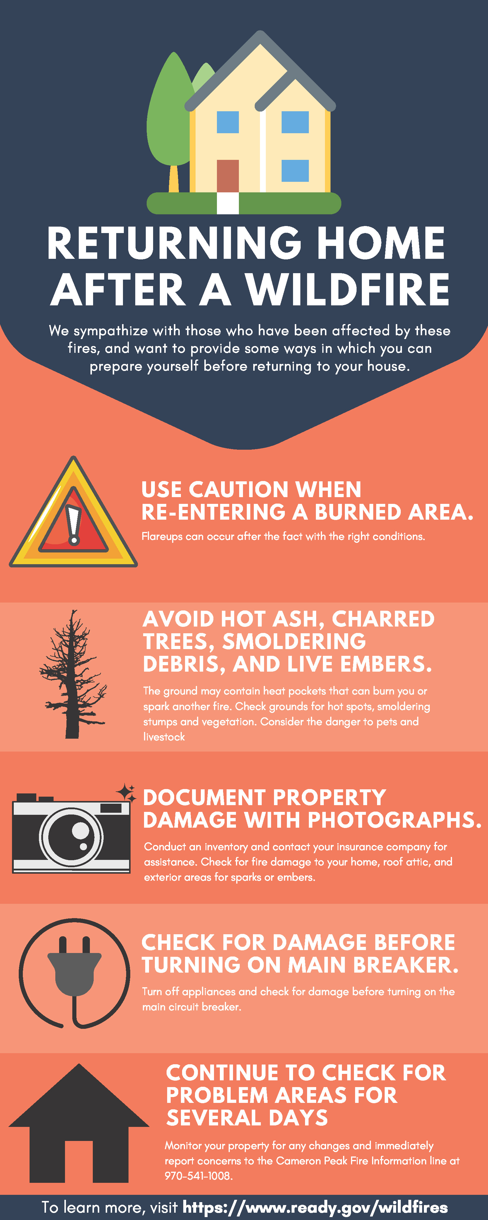
Returning home after a wildfire
Related Incident:
Publication Type: Announcement
Coming home after a wildfire can be difficult. Not only the physical ramifications, but the emotional toll it can take. The damage to property is unknown to many homeowners. We sympathize with those who have been affected by these fires, and want to provide some ways in which you can prepare yourself before returning to your house. Check out the infographic attached below to get ideas for things that you need to do once you’re able to return to your home. Visit https://www.larimer.org/wildfire-resources for recovery resources for residents impacted by the 2020 Larimer County wildfires.
Once an initial assessment is done, it’s important to take extra precaution during the clean-up phase.
- Wear protective clothing, including a long-sleeved shirt, long pants, work gloves, appropriate cloth face coverings or masks, and sturdy thick-soled shoes during clean-up efforts.
- When cleaning up ash, use a respirator to limit exposure. People with asthma and/or other lung conditions should take precautions in areas with poor air quality, as it can worsen symptoms.
- Wildfires dramatically change landscape and ground conditions, which can lead to increased risk of flooding due to heavy rains, flash flooding and mudflows. Flood risk remains significantly higher until vegetation is restored. Prepare your property for these types of potential further damage.
- Consult experts on the best way to restore and plant your land with fire-safe landscaping.
Most importantly, be available for family, friends, and neighbors who may need someone to talk to. Many people may already feel fear and anxiety during this pandemic. The threat of a wildfire can add additional stress. You may need to talk to someone, too. Don’t be afraid to reach out to friends, family, or professionals if you need help coping with your stress, anxiety, or grief. If you are struggling with stress, anxiety, or grief and need someone to talk to, please reach out to Colorado Crisis Services by calling 1-844-493-8255 or text "TALK" to 38255.
Check out https://www.ready.gov/wildfires for more information on how to safely repopulate after a wildfire.
All Mandatory and Voluntary Evacuations Lifted
Related Incident:
Publication Type: News
Larimer County officials have lifted all mandatory and all voluntary evacuations for the Cameron Peak fire and the East Troublesome fire. All residents and business occupants that were under evacuations for both fires may now return to their homes and businesses with no restrictions. Coming home after a wildfire can be difficult. Not only the physical ramifications, but the emotional toll it can take. The damage to property is unknown to many homeowners. We sympathize with those who have been affected by these fires, and remind you to watch out for any hazards including fire weakened trees, downed lines, and smoldering materials of any sort. Firefighters remind you to "Look Up, Look Down, and Look All Around". Smoke will be visible within the interior of the fire area until inclement weather arrives. LCSO reminds you to only call 9-1-1 if you are in danger.
Cameron Peak Fire
Size: 208,913 acres
Containment: 85%
Start Date: Aug. 13, 2020
Cause: Under Investigation
Thompson Zone
Size: 4,889 acres
Containment: 31%
Start Date: Oct. 22, 2020
Cause: Spot fire from East Troublesome Fire
Total Personnel on both fires: 1,202
Join the Cameron Peak Fire and Thompson Zone Fire virtual community meeting tonight at 7:30pm on Facebook Live
Actualizacin Lunes 2 de Noviembre
Related Incident:
Publication Type: News
Incendio Cameron Peak
Incendio East Troublesome Zona Thompson
Actualización – Lunes, 2 de Noviembre, 2020 @ 9:00 a.m.
Rob Allen, Comandante del Incidente
Información: 970-541-1008
Inciweb: https://inciweb.nwcg.gov/incident/6964/
Correo Electrónico: 2020.cameronpeak@firenet.gov
Facebook: https://www.facebook.com/CameronPeakFire
Condado de Larimer Centro de Información: 970-980-2500 Nota especiál: el centro de información del Condado de Larimer cerrará permanentemente esta noche a las 5pm. Para más información vaya a www.larimer.org/wildlfire-resources
YouTube: www.youtube.com/channel/UCPNA6qSJC2UYKz68rp9etvA
East Troublesome – Zona Grand: 970-445-2910
Incendio Cameron Peak
Tamaño: 208,913 acres
Contención: 85%
Reportado: Ago. 13, 2020
Causa: Bajo investigación
Personal Total: 1,202
Zona Thompson
Tamaño: 4,889 acres
Contención: 31%
Reportado: Oct. 22, 2020
Causa: punto del Incendio East Troublesome
Habrá una reunión de la comunidad virtual esta noche a las 7:30pm por Facebook Live.
Los bomberos se han aprovechado del clima cálido y la nieve derretida para limpiar y controlar más los perímetros de ambos incendios. El incendio de Cameron Peak tiene una contención de 85% y la zona de Thompson del incendio East Troublesome tiene una contención de 31%. A medida que continúa el deshielo, los bomberos están accediendo a áreas que continúan mostrando humo y continuarán asegurando el perímetro de incendios donde sea necesario.
No se veía humo en el derrame de North Fork cerca de Glen Haven el Domingo. Se espera que aumente el potencial de combustión lenta y rastreo en las áreas de Pingree Park, Cedar Park, North Fork y Thompson Zone a medida que aumentan las temperaturas y hay más terreno abierto sin nieve, aunque existe un potencial limitado para un comportamiento significativo del fuego.
Los bomberos continuarán monitoreando y patrullando las áreas declaradas contenidas. La reparación de supresión ha comenzado alrededor de estas partes contenidas del perímetro y el equipo que ya no es necesario está siendo retirado de la línea de fuego. Se está utilizando equipo pesado tanto para la reparación de supresión como para despejar carreteras. El humo será visible desde el interior de estos incendios a medida que los combustibles pesados, como los troncos caídos, continúen ardiendo y ardiendo, pero actualmente no representan un riesgo de propagación del fuego.
EVACUACIONES: para actualizaciones, envíe un mensaje de texto con la palabra LCEVAC al 888777 desde su teléfono celular. La información de emergencia se enviará según sea necesario. Ésta es la mejor manera de obtener información sobre la situación en su área. Llame a la Cruz Roja al 800-417-0495. Presione # 1 si ha sido evacuado y necesita refugio. También puede visitar http://cowyredcrossblog.org/cpf/ para obtener actualizaciones.
CIERRES: Todo el Parque Nacional de las Montañas Rocosas está cerrado. Todas las tierras del Bosque Nacional en el Distrito de Guardaparques de Canyon Lakes están cerradas.
Condado de Larimer: https://nocoalert.org
Bosque Nacional de Arapahoe y Roosevelt: https://www.fs.usda.gov/arp/alerts-notices/?aid=60887
Parque Nacional de las Montañas Rocosas: https://www.nps.gov/romo/learn/fireinformation-and-regulations.html
RECURSOS: 2 equipos de tipo hotshot, 22 equipos de tipo 2, 80 camiones, 10 topadores, 13 helicópteros, and 18 camiones de agua.
TIEMPO/CLIMA: Vientos racheados durante el día, con temperaturas entre 55-59 grados en elevaciones más altas, y más de 60 grados en elevaciones más bajas.Para obtener información sobre el humo y la calidad del aire, visite: https://wildlandfiresmoke.net/outlooks/CentralColoradoFrontRange
Restricción temporal de vuelo (RTV): Hay un RTV sobre el incendio de Cameron Peak. Los incendios forestales son una zona prohibida para los drones. Si usted vuela, no podemos. Siempre que se detecta un dron cerca del fuego, todos los aviones no pueden volar hasta que podamos estar seguros de que el dron está fuera del área. Para obtener más información, visite http://knowbeforeyoufly.org