
UpdateNovember 29 2020
Related Incident:
Publication Type: News
Cameron Peak Fire
Update – Sunday, November 29, 2020 @ 9 a.m.
Charlie Patterson, Incident Commander
Email: 2020.cameronpeak@firenet.gov
BAER (Burned Area Emergency Response) dedicated InciWeb page: https://inciweb.nwcg.gov/incident/7210/
Facebook: https://www.facebook.com/CameronPeakFire
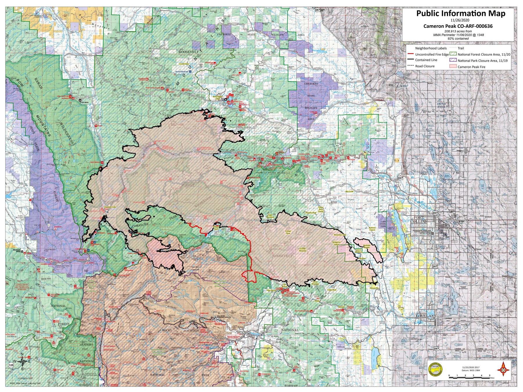
Size: 208,913 acres Containment: 94% Start Date: Aug. 13, 2020 Cause: Under Investigation Personnel: 260
Current Situation: As forecasted by our Incident Meteorologist and Fire Behavior Analyst, this area is in a drying trend with elevated fire danger. Yesterday, firefighters from the Suppression Group responded and provided assistance to control an escaped campfire near the Kelly Flat area north of Cameron Peak Fire. A Stage 2 Fire Restriction, which includes a prohibition of all campfires, remains in effect on the Canyon Lakes Ranger District (please see “Arapaho and Roosevelt National Forests Closures” in the Closures section below). For tips on making your home or property more defensible from fire, please see the Firewise website at: https://www.nfpa.org.
Overall, firefighters had a good day yesterday. They reached and put out additional hotspots. Fire containment remains at 94%. Today fire behavior is expected to be minimal, but there is increased potential for fire behavior on Monday.
The Fuels Reduction Group continued working in the northwestern area of the fire, using equipment for hazardous timber removal. Road grading has begun on Road 169. The Repair Group continued to rehab fire line and finished chipping operations along Road 139. The Suppression Group worked on the southern fire perimeter. The Structure Protection Group continued to patrol and monitor the fire’s perimeter in the Glen Haven area and completed removal of hose lays around structures. No additional flights are currently being conducted but the helicopter remains on location if needed.
Today, the Fuels Reduction Group will continue working in the northwestern part of the fire. The Repair Group will continue chipping operations and plans to move equipment across the river to repair a dozer line near the Fish Hatchery. The Suppression Group will monitor for fire activity in the bulge and monitor and mop up hot spots in Pingree. They will monitor four heat signatures in the Comanche Lake area that were identified during last night’s infrared flight and will continue efforts to reach them as conditions allow.
The Structure Protection Group will patrol and remove equipment from the Glen Haven area, including sprinklers and hoses from homeowners’ rooftops. They also will provide support to the Suppression Group as needed today.
Special Notes: The Deadman Road/County Road 86 remains closed. Please do not drive on or hunt off this road. To better understand the dangers in this area, visit https://youtu.be/7IxHA94omm0.
Closures:
Arapaho and Roosevelt National Forests closures: https://www.fs.usda.gov/alerts/arp/alerts-notices
Rocky Mountain National Park: https://www.nps.gov/romo/learn/fire-information-and-regulations.htm
Larimer County road closures: https://nocoalert.org
Advisories:
Please do not fly drones over the fire where helicopters are working. WE CANNOT FLY IF YOU DO.
Please respect road closures. Traffic on closed roads creates safety hazards for firefighters and other vehicles.
Weather: A dry cold front passed through the burn area last night bringing a very cold and dry airmass with it. Today’s forecast is for clear skies, a low relative humidity of 30-40% and light winds. Maximum temperatures above 8,000 feet will be 25-30 degrees. A drier, warmer and windier pattern is forecast to last into next week.
Resources: 3 Crews, 1 Helicopter, 7 Engines, 1 Dozer, 4 Ambulances, 6 Excavators, 5 feller bunchers, 7 skidders, 2 Chippers and overhead staff.
Repair: Please email questions regarding needed suppression repairs on state and private lands to oem@larimer.org.
Debris disposal: For updates on Larimer County Landfill closures and changes to restrictions, text Fire Debris to 56525, visit www.larimer.org/solidwaste or call (970) 498-5760.
Actualizacin Viernes 28 de Noviembre 2020
Related Incident:
Publication Type: News
Incendio Cameron Peak 28 de Noviembre 2020
Información: 970-541-1008
Correo Electrónico: 2020.cameronpeak@firenet.gov
YouTube: www.youtube.com/channel/UCPNA6qSJC2UYKz68rp9etvA
Inciweb: htps://inciweb.nwcg.gov/incident/6964/
Recuperación a Emergencias del Área Quemada (BAER) página dedicada de InciWeb: https://inciweb.nwcg.gov/incident/7210/
Facebook: htps://www.facebook.com/CameronPeakFire
Tamaño: 208,913 acres Contención: 94% Reportado: Agosto 13, 2020 Causa: Bajo Investigación Personal: 264
Situación actual Ayer, los bomberos alcanzaron y apagaron dos puntos de acceso muy remotos en el área de Pingree y trataron a un tercero cerca del campus de CSU Mountain. Este trabajo permitió al equipo de gestión de incidentes aumentar la contención del fuego del 92 al 94%.
El Grupo de Reducción de Combustibles trabajó en el área noroeste del incendio realizando reducción de combustibles y nivelación de carreteras, especialmente en las carreteras 86, 212, 319 y 517. El grupo de reparación continuó rehabilitando la línea de topadoras y astillando a lo largo de la carretera 139. Deberían terminar esa sección en aproximadamente 2 días más. Las reparaciones de la línea de topadoras cerca del criadero de peces deben completarse en aproximadamente 3-4 días. El Grupo de Supresión trabajó en el perímetro de incendios sur en el "bulto". Como resultado, se ha declarado contenida una sección adicional de la línea de fuego. El grupo planea ubicar y limpiar un tercer punto sospechoso en el bulto hoy. El Grupo de Protección de Estructura continuó patrullando y monitoreando el perímetro del incendio en las áreas de Glen Haven y Storm Mountain. Comenzaron a retirar 40-50 bombas portátiles y cerca de 6,000 pies de manguera contra incendios.
Se espera que el comportamiento del fuego vuelva a ser mínimo hoy. Los días cortos mantienen a los combustibles finos a la sombra durante la mayor parte del día, y existe una probabilidad muy baja de que estos combustibles puedan ser portadores de fuego.
Hoy el Grupo de Reducción de Combustibles seguirá trabajando en la parte noroeste del incendio. El Grupo de Reparación se concentrará en astillar a lo largo de la Carretera 139. El Grupo de Supresión continuará limpiando alrededor de la universidad. El grupo de protección de estructuras continuará patrullando y retirando equipos de Glen Haven y Storm Mountain. También brindarán apoyo al Grupo de Represión. Si las condiciones lo permiten esta tarde, el helicóptero Tipo 3 ayudará al Grupo de Supresión con el reconocimiento en el área de "abultamiento" para ubicar el calor y proporcionar conciencia de la situación.
Cierres:
Arapaho y el Bosque Nacional Roosevelt Cerrados: https://www.fs.usda.gov/alerts/arp/alerts-notices/
Parque Nacional de Rocky Mountain: https://www.nps.gov/romo/learn/fire-information-and-regulations.htm
Cierres de carreteras del Condado de Larimer: https://nocoalert.org
Advertencias:
Por favor no vueles drones sobre el área del incendio donde están trabajando los helicópteros. NO PODEMOS VOLAR SI USTED LO HACE.
Por favor, respete los cierres de carreteras. Tráfico se ha visto en carreteras cerradas en el área del incendio y esto crea problemas de seguridad para los bomberos y para usted.
Tiempo/clima:
Los vientos ligeros impulsados por el terreno y las bajas temperaturas afectaron el incendio de ayer. Hoy en día persisten condiciones soleadas y frías con temperaturas en los 30 y 40 grados. Un patrón más seco, cálido y ventoso debería comenzar mañana y durar hasta la próxima semana.
Recursos: 3 Brigadas, 1 Helicóptero, 10 Autobombas, 1 Dozer, 4 Ambulancias, 6 Excavadoras, 5 Taladores Apiladores, 7 Skidders, 2 Astilladoras y personal de apoyo.
Reparación: Preguntas sobre las reparaciones/rehabilitaciones de supresión necesarias en terrenos estatales y privados deben enviarse a oem@larimer.org.
Eliminación de Residuos: para obtener actualizaciones sobre los cierres de vertederos del condado de Larimer y los cambios en las restricciones, envíe un mensaje de texto a Fire Debris al 56525, visite: https://www.larimer.org/solidwaste o llame al (970) 498-5760.UpdateNovember 28 2020
Related Incident:
Publication Type: News
Cameron Peak Fire
Update – Saturday, November 28, 2020 @ 9 a.m.
Charlie Patterson, Incident Commander
Email: 2020.cameronpeak@firenet.gov
BAER (Burned Area Emergency Response) dedicated InciWeb page: https://inciweb.nwcg.gov/incident/7210/
Facebook: https://www.facebook.com/CameronPeakFire
Size: 208,913 acres Containment: 94% Start Date: Aug. 13, 2020 Cause: Under Investigation Personnel: 264
Current Situation: Yesterday firefighters reached and put out two very remote hotspots in the Pingree area and treated a third one near the CSU Mountain Campus. This work enabled the incident management team to increase the fire’s containment from 92 to 94%.
The Fuels Reduction Group worked in the northwestern area of the fire performing fuels reduction and road grading, especially on the 86, 212, 319, and 517 roads. The Repair Group continued to rehab dozer line and chipping along Road 139. They should finish that section in about 2 more days. Dozer line repairs near the Fish Hatchery should be completed in about 3-4 days. The Suppression Group worked on the southern fire perimeter in the “bulge.” As a result, an additional section of the fireline has been declared contained. The group plans to locate and mop-up a third suspected hot spot in the bulge today. The Structure Protection Group continued to patrol and monitor the fire’s perimeter in the Glen Haven and Storm Mountain areas. They began removing 40-50 portable pumps and about 6,000 feet of fire hose.
Fire behavior is expected to be minimal again today. Short days are keeping fine fuels shaded for most of the day, and there is a very low probability that these fuels could carry fire.
Today the Fuels Reduction Group will continue working in the northwestern part of the fire. The Repair Group will focus on chipping along Road 139. The Suppression Group will continue clean-up around the university. The Structure Protection Group will continue patrolling and removing equipment from Glen Haven and Storm Mountain. They also will provide support to the Suppression Group. If conditions allow this afternoon, the Type 3 helicopter will assist the Suppression Group with reconnaissance in the “bulge” area to locate heat and to provide situational awareness.
Special Notes: The Deadman Road/County Road 86 remains closed. Please do not drive on or hunt off this road. To better understand the dangers in this area, visit https://youtu.be/7IxHA94omm0.
Closures:
Arapaho and Roosevelt National Forests closures: https://www.fs.usda.gov/alerts/arp/alerts-notices
Rocky Mountain National Park: https://www.nps.gov/romo/learn/fire-information-and-regulations.htm
Larimer County road closures: https://nocoalert.org
Advisories:
Please do not fly drones over the fire where helicopters are working. WE CANNOT FLY IF YOU DO.
Please respect road closures. Traffic on closed roads creates safety hazards for firefighters and other vehicles.
Weather: Light, terrain-driven winds and cold temperatures affected the fire yesterday. Today, sunny and cold conditions persist with temperatures in the 30s and 40s. A drier, warmer and windier pattern should start tomorrow and last into next week.
Resources: 3 Crews, 1 Helicopter, 10 Engines, 1 Dozer, 4 Ambulances, 6 Excavators, 5 feller bunchers, 7 skidders, 2 Chippers and overhead staff.
Repair: Please email questions regarding needed suppression repairs on state and private lands to oem@larimer.org.
Debris disposal: For updates on Larimer County Landfill closures and changes to restrictions, text Fire Debris to 56525, visit www.larimer.org/solidwaste or call (970) 498-5760.
Actualizacin Viernes 27 de Noviembre 2020 9 am
Related Incident:
Publication Type: News
Incendio Cameron Peak
Actualización – Viernes, 27 de Noviembre, 2020 9 a.m.
Charlie Patterson, Comandante del Incidente
Información: 970-541-1008
Correo Electrónico: 2020.cameronpeak@firenet.gov
YouTube: www.youtube.com/channel/UCPNA6qSJC2UYKz68rp9etvA
Inciweb: htps://inciweb.nwcg.gov/incident/6964/
Recuperación a Emergencias del Área Quemada (BAER) página dedicada de InciWeb: https://inciweb.nwcg.gov/incident/7210/
Facebook: htps://www.facebook.com/CameronPeakFire
Tamaño: 208,913 acres Contención: 92% Reportado: Agosto 13, 2020 Causa: Bajo Investigación Personal: 271
Un mensaje de agradecimiento: Un sincero agradecimiento a nuestros seguidores de Facebook que aprovecharon la oportunidad para expresar gratitud a las muchas personas y organizaciones que han trabajado en el incendio de Cameron Peak durante los últimos meses. Continúe enviándolos este fin de semana festivo y nos aseguraremos de compartirlos con todas las personas asignadas al incidente.
Nota especial: Deadman Road / County Road 86 permanece cerrada. Por favor, no conduzca ni salga de esta carretera. En esta área está operando equipo pesado, grande y peligroso, y varios camiones madereros grandes recorren esta carretera. Los bomberos también trabajan aquí. A pesar de las advertencias, varios autos por día continúan pasando las señales de cierre. Por favor, mantenga a nuestros bomberos seguros para que puedan regresar a casa con sus familias en esta temporada navideña. Para comprender mejor los peligros en esta área, visite https://youtu.be/7IxHA94omm0.
Situación actual: Ayer, el Grupo de Reducción de Combustibles trabajó en la zona norte del incendio en reducción de combustibles y nivelación de caminos. El Grupo de Reparación continuó rehabilitando la línea de topadoras y las operaciones de astillado a lo largo de la carretera 139. Se espera que su trabajo demore aproximadamente una semana. El Grupo de Supresión localizó y extinguió varios puntos calientes en el perímetro de incendios sur en el área de Pingree. El Grupo de Estructura continuó patrullando y monitoreando el perímetro del incendio en las áreas de Glen Haven y Storm Mountain.
Se espera que el comportamiento del fuego vuelva a ser mínimo hoy. Los días cortos y menos luz solar mantienen los combustibles de basura (fina, pequeña) a la sombra durante la mayor parte del día; esos combustibles no llevan fuego fácilmente en este momento.
Hoy el Grupo de Reducción de Combustibles seguirá trabajando en la parte norte del incendio. El Grupo de Reparación se concentrará en astillar a lo largo de la carretera 139. El Grupo de Supresión limpiará alrededor de la universidad. El grupo también planea explorar el área del "bulto" para determinar si puede ubicar de manera segura y tomar medidas sobre las fuentes de calor allí. El Grupo de Estructura trabajará en el monitoreo y patrullaje sureste, verificando el equipo y brindando apoyo al Grupo de Supresión. Si las condiciones son las adecuadas esta tarde, el helicóptero Tipo 3 ayudará al Grupo de Supresión con el reconocimiento en el área de "abultamiento" para localizar el calor y obtener cierta conciencia de la situación aérea.
Cierres:
· Arapaho y el Bosque Nacional Roosevelt Cerrados: https://www.fs.usda.gov/alerts/arp/alerts-notices/
· Parque Nacional de Rocky Mountain: https://www.nps.gov/romo/learn/fire-information-and-regulations.htm
· Cierres de carreteras del Condado de Larimer: https://nocoalert.org
Advertencias:
· Por favor no vueles drones sobre el área del incendio donde están trabajando los helicópteros. NO PODEMOS VOLAR SI USTED LO HACE.
· Por favor, respete los cierres de carreteras. Tráfico se ha visto en carreteras cerradas en el área del incendio y esto crea problemas de seguridad para los bomberos y para usted.
Tiempo/clima: Vientos ligeros impulsados por el terreno y temperaturas frías afectaron el incendio de ayer cuando un frente frío débil, principalmente seco, pasó sobre el área. Lluvias ligeras de nieve espolvorearon el área del fuego por la tarde y noche. Hoy en día, se pronostican cielos soleados con temperaturas en los 30 grados. Es probable que se mantenga un patrón más seco y ventoso a partir de mañana y hasta la próxima semana.
Recursos: 3 Brigadas, 1 Helicóptero, 10 Autobombas, 1 Dozer, 4 Ambulancias 7 Excavadoras, 2 Astilladoras, 4 Autocargardores, 5 Procesadores y personal de apoyo.
Reparación: Preguntas sobre las reparaciones/rehabilitaciones de supresión necesarias en terrenos estatales y privados deben enviarse a oem@larimer.org.
Eliminación de Residuos: (El Vertedero del Condado de Larimer) https://www.larimer.org/solidwaste , Oficina 970-498-5760. Para obtener actualizaciones sobre el cierre del vertedero y cambios en las restricciones, también puede enviar el mensaje de texto Fire Debris al 56525.
###
Update Friday Noveber 27 2020 9am
Related Incident:
Publication Type: News
Cameron Peak Fire
Update – Friday, November 27, 2020 @ 9 a.m.
Charlie Patterson, Incident Commander
· Fire Information: 970-541-1008
· Email: 2020.cameronpeak@firenet.gov
· YouTube:www.youtube.com/channel/UCPNA6qSJC2UYKz68rp9etvA
· InciWeb: https://inciweb.nwcg.gov/incident/6964/
· BAER (Burned Area Emergency Response) dedicated InciWeb page: https://inciweb.nwcg.gov/incident/7210/
· Facebook: https://www.facebook.com/CameronPeakFire
Size: 208,913 acres Containment: 92% Start Date: Aug. 13, 2020 Cause: Under Investigation Personnel: 271
A Thank You Message: A heartfelt thank you to our Facebook followers who took the opportunity to express gratitude to the many individuals and organizations that have worked on the Cameron Peak Fire over the last few months. Please continue to send those over this holiday weekend and we will be certain to share them with everyone assigned to the incident.
Special Notes: The Deadman Road/County Road 86 remains closed. Please do not drive on or hunt off this road. Heavy, large, dangerous equipment is operating in this area, and several large logging trucks travel this road. Firefighters also work here. Despite warnings, multiple cars per day continue to drive past closure signs. Please keep our firefighters safe so they can return home to their families this holiday season. To better understand the dangers in this area, visit https://youtu.be/7IxHA94omm0.
Current Situation: Yesterday, the Fuels Reduction Group worked in the northern area of the fire on fuels reduction and grading roads. The Repair Group continued to rehab dozer line and chipping operations along Road 139. Their work is expected to take about a week. The Suppression Group located and extinguished several hot spots on the southern fire perimeter in the Pingree area. The Structure Group continued to patrol and monitor the fire’s perimeter in the Glen Haven and Storm Mountain areas.
Fire behavior is expected to be minimal again today. Short days and less sunlight are keeping litter (fine, small) fuels shaded for most of the day; those fuels are not carrying fire readily at this time.
Today the Fuels Reduction Group will continue working in the northern part of the fire. The Repair Group will focus on chipping along Road 139. The Suppression Group will clean up around the university. The group also plans to scout the “bulge” area to determine whether it can safely locate and take action on heat sources there. The Structure Group will work in the southeast monitoring and patrolling, checking on equipment and providing support to the Suppression Group. If conditions are right this afternoon, the Type 3 helicopter will assist the Suppression Group with reconnaissance in the “bulge” area to locate heat and get some aerial situational awareness.
Closures:
· Arapaho and Roosevelt National Forests closures: https://www.fs.usda.gov/alerts/arp/alerts-notices
· Rocky Mountain National Park: https://www.nps.gov/romo/learn/fire-information-and-regulations.htm
· Larimer County road closures: https://nocoalert.org
Advisories:
· Please do not fly drones over the fire where helicopters are working. WE CANNOT FLY IF YOU DO.
· Please respect road closures. Traffic on closed roads creates safety hazards for firefighters and other vehicles.
Weather: Light, terrain-driven winds and cold temperatures affected the fire yesterday as a weak, mainly dry, cold front passed over the area. Light snow showers dusted the fire area in the afternoon and evening. Today, sunny skies are forecasted with temperatures in the 30s. A drier, windier pattern remains likely starting tomorrow and into next week.
Resources: 3 Crews, 1 Helicopter, 10 Engines, 1 Dozer, 4 Ambulances, 7 Excavators, 2 Chippers, 4 skidders, 5 feller bunchers and overhead staff.
Repair: Please email questions regarding needed suppression repairs on state and private lands to oem@larimer.org.
Debris disposal: For updates on Larimer County Landfill closures and changes to restrictions, text Fire Debris to 56525, visit www.larimer.org/solidwaste or call (970) 498-5760.
###
Actualizacion 26 de Noviembre 2020
Related Incident:
Publication Type: News
Tamaño: 208,913 acres Contención: 92% Reportado: Agosto 13, 2020 Causa: Bajo Investigación Personal: 290
Un mensaje de Acción de Gracias: De nuestra familia Gold Team a la suya, nos gustaría desearles a todos un Feliz Día de Acción de Gracias. Sabemos que este ha sido un año difícil para muchos de muchas maneras diferentes. Agradecemos su amabilidad y hospitalidad. También estamos agradecidos por nuestras familias y amigos en casa que celebran el Día de Acción de Gracias sin nosotros hoy.
Nota especial: Deadman Road / County Road 86 permanece cerrada. Por favor, no conduzca ni salga de esta carretera. En esta área está operando equipo pesado, grande y peligroso, y varios camiones madereros grandes recorren esta carretera. Los bomberos también trabajan aquí. A pesar de las advertencias, varios autos por día continúan pasando las señales de cierre. Por favor, mantenga a nuestros bomberos seguros para que puedan regresar a casa con sus familias en esta temporada navideña. Para comprender mejor los peligros en esta área, visite https://youtu.be/7IxHA94omm0.
Situación actual: Ayer, los vientos eran ligeros e impulsados por el terreno en lugares protegidos y por debajo de los 8,000 pies, aunque se notaron ráfagas de 30-40 mph en el lago Comanche y alrededor del incendio. Bajo pleno sol, las temperaturas subieron unos cinco grados por encima del pronóstico, 35-45 grados en general.
Se espera que el comportamiento del fuego vuelva a ser mínimo hoy. Los combustibles todavía están cubiertos de nieve o húmedos por el derretimiento. Las bajas temperaturas, así como los días cortos y los períodos de combustión continuarán drenando energía del fuego. Puede que continúe la combustión de combustibles pesados.
Hoy el Grupo de Reducción de Combustibles monitoreará y patrullará. También trabajarán con Ground Support utilizando equipo de carretera para abrir / acceder a carreteras cubiertas de nieve para permitir que el trabajo continúe. También realizarán reparaciones de supresión y trabajarán con el asesor de recursos en reparaciones prioritarias. El grupo de Combustibles transportará todos los equipos y suministros innecesarios y acondicionará los sistemas de manejo de agua para el invierno. El Grupo de supresión llevará a cabo la reparación de supresión cuando sea necesario. El Grupo de Estructura patrullará, monitoreará y asegurará las estructuras y mejoras alrededor del perímetro del incendio en las áreas de Glen Haven y Storm Mountain.
Cierres:
Arapaho y el Bosque Nacional Roosevelt Cerrados: https://www.fs.usda.gov/alerts/arp/alerts-notices/
Parque Nacional de Rocky Mountain: https://www.nps.gov/romo/learn/fire-information-and-regulations.htm
Cierres de carreteras del Condado de Larimer: https://nocoalert.org
Advertencias:
Por favor no vueles drones sobre el área del incendio donde están trabajando los helicópteros. NO PODEMOS VOLAR SI USTED LO HACE.
Por favor, respete los cierres de carreteras. Tráfico se ha visto en carreteras cerradas en el área del incendio y esto crea problemas de seguridad para los bomberos y para usted.
Tiempo/clima:
Se anticipa otra posibilidad de precipitación ligera esta tarde, aunque se espera que este sistema sea más seco con menos de 1/10 ”de nieve. Es probable que haya un patrón más seco y ventoso este fin de semana y la próxima semana.
Recursos: 3 Brigadas, 1 Helicóptero, 10 Autobombas, 1 Dozer, 4 Ambulancias 12 Excavadoras, 4 Astilladoras, 4 Autocargardores, 5 Procesadores y personal de apoyo.
Reparación: Preguntas sobre las reparaciones/rehabilitaciones de supresión necesarias en terrenos estatales y privados deben enviarse a oem@larimer.org.
Eliminación de Residuos: (El Vertedero del Condado de Larimer) https://www.larimer.org/solidwaste , Oficina 970-498-5760. Para obtener actualizaciones sobre el cierre del vertedero y cambios en las restricciones, también puede enviar el mensaje de texto Fire Debris al 56525.

Update Wednesday November 25 2020 9 am
Related Incident:
Publication Type: News
Charlie Patterson, Incident Commander
Size: 208,913 acresContainment: 92%Start Date: Aug. 13, 2020Cause: Under InvestigationPersonnel: 284
Special Notes: The Deadman Road/County Road 86 remains closed. Please do not drive on or hunt off this road. Heavy, large, dangerous equipment is operating in this area, and several large logging trucks travel this road. Firefighters also work here. Despite warnings, multiple cars per day continue to drive past closure signs. Please keep our firefighters safe so they can return home to their families this holiday season. To better understand the dangers in this area, visit https://youtu.be/7IxHA94omm0.
Current Situation: The fire displayed minimal activity again yesterday. Precipitation, as well as freezing and thawing temperatures, created hazardous road conditions. Ambulances were unable to traverse the roads. As a result, the Repair and Fuels Reduction Groups stayed in staging. The Suppression Group continued to scout the Pingree Park area while the Structure Group monitored around Estes Park and checked on equipment for potential weather damage.
Snow-covered and wet fuels will lead to minimal fire behavior again today. A Multi-Mission Aircraft (MMA) flew over the fire, and its infrared capabilities detected eight hot spots in the Pingree Park and North Fork slop-over / “bulge” areas. The Fuels Reduction Group will continue to focus on decking and moving logs cut during fire suppression in the north and northeast sections of the fire. The Rehab Group will focus on restoring roads, repairing fire lines and diminishing and redistributing berms. The Suppression Group will continue to patrol and monitor around Colorado State University, as well as try to identify the eight hot spots detected by the MMA. The Structure Group will patrol in the south and southeast near Pingree Park, where a smoke or two may be visible, as well as Glenhaven, The Retreat and the “bulge.”
Closures:
-
Arapaho and Roosevelt National Forests closures: https://www.fs.usda.gov/alerts/arp/alerts-notices
-
Rocky Mountain National Park: https://www.nps.gov/romo/learn/fire-information-and-regulations.htm
-
Larimer County road closures: https://nocoalert.org
A
dvisories:
-
Please do not fly drones over the fire where helicopters are working. WE CANNOT FLY IF YOU DO.
-
Please respect road closures. Traffic on closed roads creates safety hazards for firefighters and other vehicles.
Weather: A drier air mass is expected to move in today with low humidity and sporadic wind gusts of up to 50 mph. Wind and chilly conditions will persist throughout the day with highs in the 30s. Light snow is possible tomorrow. Dry, sunny, windier conditions will move into the area this weekend and remain into next week.
Resources: 3 Crews, 1 Helicopter, 10 Engines, 1 Dozer, 14 Excavators, 5 Chippers, 4 skidders, 5 feller bunchers and overhead staff.
Repair: Please email questions regarding needed suppression repairs on state and private lands to oem@larimer.org.
Debris disposal: For updates on Larimer County Landfill closures and changes to restrictions, text Fire Debris to 56525, visit www.larimer.org/solidwaste or call (970) 498-5760.
Fire Information: 970-541-1008
Email: 2020.cameronpeak@firenet.gov
BAER (Burned Area Emergency Response) dedicated InciWeb page: https://inciweb.nwcg.gov/incident/7210/
Facebook: https://www.facebook.com/CameronPeakFire
Actualizacion Lunes 24 de Noviembre 2020 9am
Related Incident:
Publication Type: News
Charlie Patterson, Comandante del Incidente
Tamaño: 208,913 acres Contención: 92% Reportado: Ago. 13, 2020 Causa: Bajo Investigación Personal: 318
Nota especial: La Deadman Road/County Road 86 permanece CERRADA. NO CONDUZCA por esta carretera. Por favor, NO CAZES desde esta carretera. Manténgase afuera de los cierres forestales. Hay maquinaria pesada, grande y peligrosa operando en esta área, y varios camiones grandes de tala que viajan por esta carretera. Además, los bomberos están a pie en esta carretera. Nuestros jefes de maquinaria pesada y supervisores de la división nos han pedido que, una vez más, solicitemos al público que se mantenga afuera de esta carretera. Se están viendo varios autos por día que pasan por las señales de cierre y han expresado preocupación por su seguridad y las de su brigada. Vaya a https://youtu.be/7IxHA94omm0 para comprender mejor por qué estas carreteras no son seguras. Gracias por ayudar a mantener seguro nuestros bomberos para que puedan regresar a su hogar con sus familias en esta temporada festiva.
Situación Actual: Muy poco humo se observó sobre el incendio Cameron Peak según el informe de la sección de operaciones. Una aeronave multi-misión (Multi-Mission Aircraft “MMA”) voló sobre el fuego, y sus capacidades infrarrojas detectaron mínima áreas hipertérmicas en Pingree Park y el fuego escapado de North Fork, conocido como “The Bulge”. El analista de comportamiento del fuego pronostica que el comportamiento del fuego de hoy también será mínimo, con poco o ningún humo visible. La nieve comenzó a caer sobre el área del incendio ayer hasta anoche, con acumulaciones de una a tres pulgadas.
Hoy, los jefes del incendio Cameron Peak están reorganizando los recursos en “Grupos" en vez de "Divisiones". Se establecen grupos para dividir el incidente en áreas funcionales de operación. Los grupos se componen de recursos reunidos para realizar una función especial no necesariamente dentro de una sola división geográfica. El incendio Cameron Peak contará con un "Grupo de reducción de combustibles forestales" que se enfoca en el astillado y movimiento de troncos que fueron cortados durante actividades contraincendios. Gran parte de su trabajo se concentrará en las secciones norte y noreste. Habrá un "Grupo de rehabilitación" cuyos miembros restaurarán carreteras, reducirán o redistribuirán las bermas o los montículos de materiales forestales creado por los dozers y reducirán el acceso a carreteras y líneas del incendio que no pertenecen al sistema de carreteras. Un "Grupo de Extinción" trabajará principalmente en y alrededor del área de la Colorado State University en Pingree Park, liquidando y fragmentando áreas de combustibles forestales concentrados. Además, este Grupo continuará la rehabilitación de la línea de fuego en esta área. El “Grupo de Estructura” constará de varias autobombas que patrullaran las áreas del sur y sureste cerca de Pingree Park, Glenhaven, The Retreat, y “The Bulge”. Los helicópteros siguen disponibles para el Incendio Cameron Peak; sin embargo, los vientos impidieron su uso ayer. Hoy se vuelven a pronosticar vientos y nieve, por lo tanto, es poco probable que vuelen hoy; La gestión de riesgos siempre estará a la vanguardia de cualquier decisión relacionada con la utilización de aeronaves. Hay nieve y condiciones heladas hoy en la carretera en el área del incendio, por lo tanto, las operaciones dependerán del medio ambiente/clima.
Advertencias:
-
Por favor no vueles drones sobre el área del incendio donde están trabajando los helicópteros. NO PODEMOS VOLAR SI USTED LO HACE.
-
Por favor, respete los cierres de carreteras. Tráfico se ha visto en carreteras cerradas en el área del incendio y esto crea problemas de seguridad para los bomberos y para usted.
Tiempo/clima: Clima invernal por la mañana con chubascos de nieve y neblina irregular ocurrió después del frente frío anoche. Se esperan 1-3 pulgadas de nieve. Hoy hay condiciones ventosas, cielos continuamente despejándose y permanece el frío a 20-30 por encima de 8,000 pies / 30-35 por debajo de 8,000 pies. La humedad mínima debe ser 30-40% por encima de 8,000 pies / 35-45% por debajo de 8,000 pies. Sensaciones térmicas cerca de 20 por la mañana, con vientos del lado oeste NNO 10-20 mph, ráfagas de 25 mph, cambiando a SO más tarde en el día. En el lado este, habrá vientos terrenales de 5-10 mph. Otra ronda de vientos fuertes está pronosticada esta noche y miércoles con otro frente que pasa, seguido de lluvias ligeras de nieve el jueves.
Recursos: 3 Brigadas, 2 Helicópteros, 6 Autobombas, 1 Dozer, 15 Excavadoras, 5 Astilladoras, 1 Autocargardor, 5 Procesadores y personal de apoyo.
Reparación: Preguntas sobre las reparaciones/rehabilitaciones de supresión necesarias en terrenos estatales y privados deben enviarse a oem@larimer.org.
Eliminación de Residuos: (El Vertedero del Condado de Larimer) https://www.larimer.org/solidwaste , Oficina 970-498-5760. Para obtener actualizaciones sobre el cierre del vertedero y cambios en las restricciones, también puede enviar el mensaje de texto Fire Debris al 56525.
Cierres: Cierres del Bosque Nacional de Arapahoe y Roosevelt: https://www.fs.usda.gov/alerts/arp/alerts-notices/
Parque Nacional de Rocky Mountain: https://www.nps.gov/romo/learn/fire-information-and-regulations.htm
Cierres de carreteras del Condado de Larimer: htps://nocoalert.org
Cameron Peak Fire Update Tuesday November 24 2020
Related Incident:
Publication Type: News
Size: 208,913 acres Containment: 92% Start Date: Aug. 13, 2020 Cause: Under Investigation Personnel: 318
Special Notes: The Deadman Road/County Road 86 remains CLOSED. Please DO NOT DRIVE on this road. Please DO NOT HUNT off this road. Please stay out of Forest closures. There is heavy, large and dangerous equipment operating in this area, and there are multiple, large logging trucks traveling this road. In addition, fire staff are on foot on this road. Our Heavy Equipment Bosses and Division Supervisors have asked us to, once again, request the public stay off this road. They are seeing multiple cars a day drive past closure signs and have expressed concern for their and their crews’ safety. Go to https://youtu.be/7IxHA94omm0 for a better understanding of why these roads are unsafe. Thank you for helping keep our fire staff safe so they can return home to their families this holiday season.
Current Situation: Operations staff reported very little smoke over the Cameron Peak Fire yesterday. A Multi-Mission Aircraft (MMA) flew over the fire, and its infrared capabilities detected minimal heat in the Pingree Park and North Fork slop-over / “bulge” areas. The Fire Behavior Analyst predicts that today’s fire behavior will also be minimal, with little to no smoke visible. Snow began to fall over the fire area yesterday into last night, with accumulations of one to three inches.
Today, Cameron Peak fire managers are reorganizing resources into “Groups” instead of “Divisions”. Groups are established to divide the incident into functional areas of operation. Groups are composed of resources assembled to perform a special function not necessarily within a single geographic division. The Cameron Peak Fire will have a “Fuels Reduction Group” that focuses on decking and moving logs that were cut during suppression activities. Much of their work will be focused on the north and northeast sections of the fire. There will be a “Rehab Group” whose members will restore roads, diminish or redistribute berms or mounded material created by dozers, and reduce access to non-system roads and fire lines. A “Suppression Group” will work mainly in and around the Colorado State University area in Pingree Park, mopping up and breaking up areas of concentrated fuels. In addition, this Group will continue fire line rehabilitation in this area. The “Structure Group” will consist of several engines that will be patrolling in the south and southeast areas near Pingree Park, Glenhaven, The Retreat, and “the bulge” area. Helicopters remain available for use on the Cameron Peak Fire; however, winds prevented their use yesterday. Winds and snow are predicted again today, so flight is unlikely; risk management will always be at the forefront of any decision regarding the utilization of aircraft. Snow and are icy roads are present in the fire area today, so overall operations will be environmentally dependent.
Advisories:
-
Please do not fly drones over the fire area where helicopters are working. WE CANNOT FLY IF YOU DO.
-
Please respect road closures. Traffic has been seen on closed roads in the fire area and this creates safety issues for firefighters and for you.
Weather: Wintery weather in the morning with snow showers and patchy fog behind last night’s cold front. 1-3 inches of snow is expected. Breezy winds under clearing skies this afternoon and remaining cold at 20-30 above 8,000 ft / 30-35 below 8,000 ft. Minimum humidity should be 30-40% above 8,000 ft / 35-45% below 8,000 ft. Wind chills near 20 in the morning, with west side winds NNW 10-20 mph, gusts to 25 mph, turning SW later in the day. On the east side, winds will be terrain driven at 5-10 mph. Another round of strong winds are forecasted for tonight and Wednesday with another passing front, followed by light snow showers Thursday.
Resources: 3 Crews, 2 Helicopters, 6 Engines, 1 Dozer, 15 Excavators, 5 Chippers, 1 Forwarder, 5 Processors, and overhead staff.
Repair: Questions regarding needed suppression repairs on state and private lands should be sent to oem@larimer.org.
Debris disposal: (Larimer County Landfill): www.larimer.org/solidwaste, business office 970-498-5760. For updates on landfill closures and changes to restrictions, you can also text Fire Debris to 56525.
Closures: Arapaho and Roosevelt National Forests closures: https://www.fs.usda.gov/alerts/arp/alerts-notices/
Rocky Mountain National Park: https://www.nps.gov/romo/learn/fire-information-and-regulations.htm
Larimer County road closures: https://nocoalert.org