
Stage 2 Fire Restrictions Remain in effect
Related Incident:
Publication Type: Closures
Stage 2 fire restrictions: No open flames, no campfires and no charcoal grills. No smoking outdoors. Do not park on grass. Make sure chains aren’t dragging. Gas camping stoves with on/off switches are OK.
Forest Fire Restrictions
County Fire Restrictions
Fire behavior moderates today red flag conditions return Friday
Related Incident:
Publication Type: News
The Williams Fork Fire remained relatively quiet through most of the day Thursday, held in check by shade from smoke drifting in from the Mullen Fire. The most activity occurred on the south "hook" where the fire has crossed below the McQueary Creek Drainage into the area between lower Bobtail Creek and Jones Creek.
A spike crew continues construction on a fuel break by thinning trees along Bottle Pass while elsewhere crews are reinforcing and strengthening previously constructed control and containment lines. Structure protection measures have been put in place where necessary. Meanwhile, air support is dropping water on hot spots around the north end of the fire to keep it cool.
Smoke will blow out of the area overnight and Red Flag conditions are expected to return tomorrow. With continued heat, wind, and low relative humidity recovery overnight, smoldering fuels continue to dry out. Fire behavior will be active when wind, slope and fuels align. Conditions for Saturday and Sunday look more favorable with a mix of clouds. However, winds, sun and warm temperatures return again Monday.
The number of people supporting the fire has increased this week from 55 to 214, and the Type 2 Northern Rockies Incident Management Team 6 is mobilizing. They are expected to assume command of the fire Sunday.
Fire will continue to be active as extreme drought conditions persist
Related Incident:
Publication Type: News
The Williams Fork Fire was active yesterday and today as red flag conditions returned to the area. The fire continued to grow in the McQueary Creek drainage near Jones pass and the Richey Creek drainage near Keyser Ridge, with two visible plumes of smoke visible from Grand, Summit and Clear Creek counties. Two Type 1 helicopters worked the north flank of the fire to keep growth in check between the fire perimeter and Keyser Creek. The weather outlook for the foreseeable future calls for continued extreme drought conditions with weather conducive to active fire behavior, including low relative humidity, temperatures 10-20 degrees warmer-than-normal, and 20 mph winds out of the west/northwest. More resources are arriving at the fire today, including crews, engines, and aircraft. A Type 2 team has been ordered. The multi-mission aircraft has flown the fire and updated acreage is expected later today. Due to the weather outlook and fire behavior, the forest closure order is expected to remain in place, as is, through at least the middle of next week.
Wind event pushes fire east into Upson Creek
Related Incident:
Publication Type: News
A wind event yesterday over Keyser Ridge pushed the Williams Fork Fire east across Richey Creek into Upson Creek. The fire grew about 300 acres in that area and is now approximately 1.5 miles southwest of Lake Evelyn (FSR 136) and Keyser Creek (FSR 139) roads. High winds grounded aircraft.
Winds on Friday pushed the southern flank of the fire east below St. Louis Peak and St. Louis Pass towards McQueary Creek, causing about 100 acres of growth. This portion of the fire held at St. Louis Pass yesterday and did not experience much additional growth.
More ground and air resources are on order. While cooler temperatures are expected through Tuesday, strong winds, low relative humidity and dry fuels are expected to keep fire behavior active over the coming days. More warm, dry days are in the forecast next week. A season-ending weather event is needed to put this fire out.
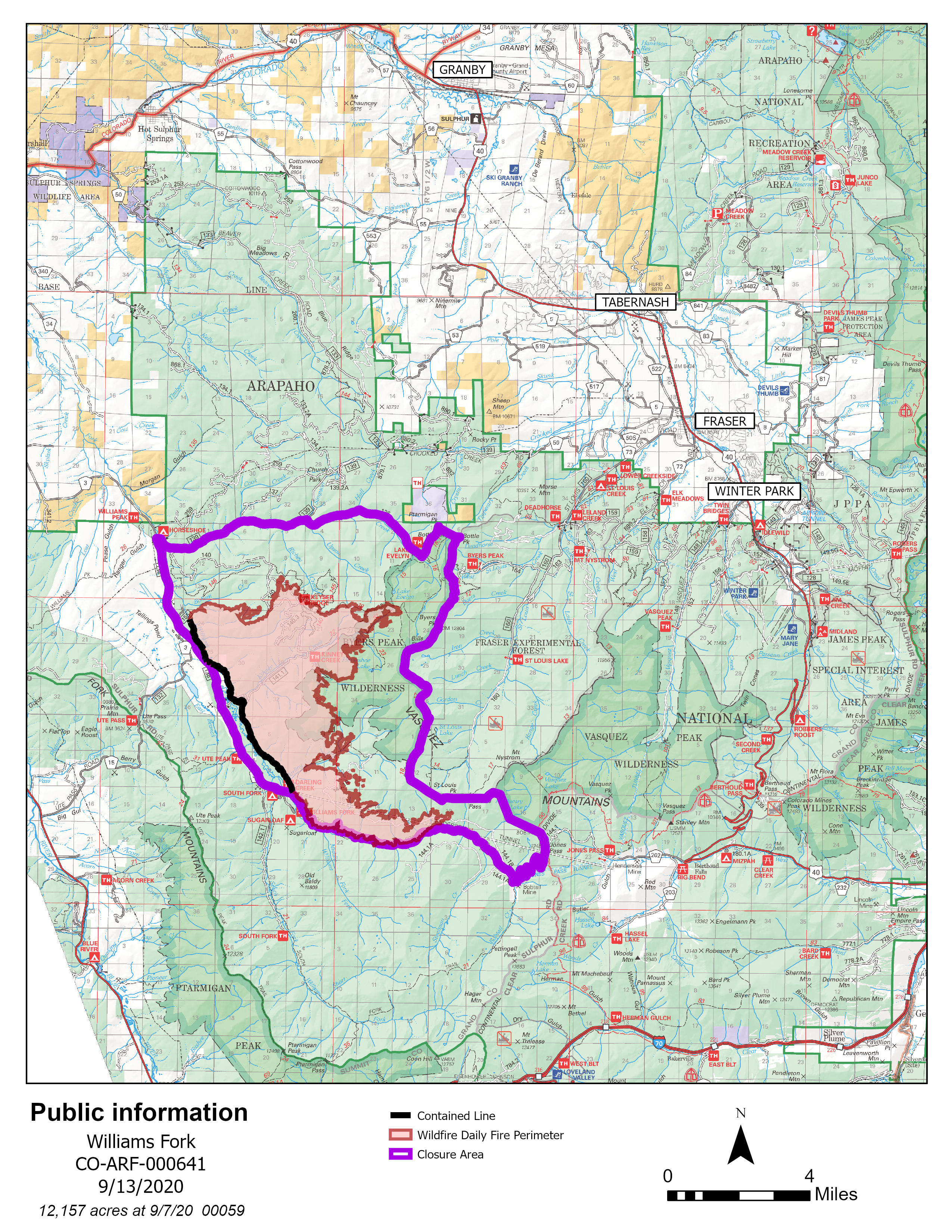
Forest closure area
Related Incident:
Publication Type: Closures
See the closure order and fire restriction information: https://www.fs.usda.gov/alerts/arp/alerts-notices/?aid=60908
Williams Fork Fire grew toward McQueary Creek more activity expected today
Related Incident:
Publication Type: News
The Williams Fork Fire was active yesterday, growing by about 100 acres in the upper Williams Fork Drainage. Activity occurred between the Williams Fork River and St. Louis Peak as west winds pushed the fire east toward McQueary Creek and the Vasquez Peak Wilderness. The northern portion of the fire near Keyser Ridge held despite the winds. Strong winds, red flag conditions and extreme fire behavior is expected today. A type 1 helicopter will continue to work the Keyser Ridge area while structure protection and direct attack will occur on the southeastern end of the fire near Jones Pass and the Vasquez Peak Wilderness.
Fire activity could increase this weekend
Related Incident:
Publication Type: News
The Williams Fork Fire continues to actively burn within its perimeter. Hot spots and smoke are visible on Keyser Ridge and below Jones Pass. The Incident Commander urges all campers and recreationists, especially those north and east of the fire closure area, to remain vigilant as warm and windy weather could cause fire behavior to increase. As needed, helicopters will be actively working in the area over the weekend. The entire area within 2 miles of the fire is a “No Drone Zone.” If you fly, we can’t.
Forest visitors near fire closure area reminded to be vigilant this weekend
Related Incident:
Publication Type: News
As another glorious fall weekend rolls around, Grand County residents and visitors are reminded that the Williams Fork Fire continues to actively burn within its perimeter. Many large hunting camps have been established in the Church Park area and the Incident Commander urges all campers and recreationists north and east of the fire closure area to remain vigilant.
Hot spots and smoke are visible on Keyser Ridge, and fire activity in that area could pick up this weekend with warm and windy weather. If needed, helicopters will be actively working in the area over the weekend. The entire area within 2 miles of the fire is a “No Drone Zone.” If you fly, we can’t.
A small amount of fire activity along Keyser Ridge in recent days added less than 5 acres to the overall fire size while burnout operations on the south side of the fire near Bobcat Creek accounted for the rest of the growth.
The fire has transitioned back to a Type 3 team led by Incident Commander Ed Leblanc and a supporting team 76 fire personnel.
Drone incursion grounds aircraft on Williams Fork Fire
Related Incident:
Publication Type: News
Fire activity yesterday picked up yesterday as warm temperatures produced smoke within the fire perimeter. Helicopters worked to cool hot spots until a drone incursion grounded them. Fire managers wish to remind the public that a "No Fly Zone" remains in place within a 2-mile radius of the fire.
Interior pockets of smoke will continue to be visible on warm days until a season-ending weather event occurs, particularly on the south end of the fire, which is holding the most heat.
Smaller Closure Area Now In Effect
Related Incident:
Publication Type: News
Due to improved weather conditions and minimal fire activity, Arapaho National Forest managers have reduced the size of the Williams Fork Fire forest closure area. Effective today, the closure area will encompass only lands, roads and trails immediately surrounding the active fire perimeter in the Williams Fork Drainage.
Roads that remain within the fire closure area include: County Road 30, the western half of Keyser Creek Road, Lake Evelyn Road, Keyser Ridge Road, Kinney Creek Road, and Jones Pass Road west of the pass.
Byers Peak Wilderness Area as well as Keyser Ridge Trailhead, Kinney Creek Trailhead, Ute Peak Trailhead, Darling Creek Trailhead, Williams Fork Trailhead and South Fork Trailhead remain in the closure area along with the Sugarloaf, South Fork and Horseshoe Campgrounds.
While snow and rain have dampened much of the fire, active hot spots continue to burn. Warmer weather and winds could increase fire activity within the perimeter. Rolling debris, falling trees, and landslides are also possible within the fire perimeter.
The reduced closure area opens up all of Blue Ridge, Church Park, the Fraser Experimental Forest, St Louis Creek, Leland Creek, Elk Meadows and Vasquez Wilderness Area. However, a road closure remains in place on Vasquez Road due to a Grand County Water and Sanitation pipe replacement project that began earlier this summer and Little Muddy Creek Road remains closed at the bridge due to damage.
See the full list and map of roads, trails and campgrounds included in the new closure area.
Extensive blowdown from storm impacts some road and trails
Sulphur District Ranger Shoshana Cooper warns the public that a major blowdown event occurred across portions of Grand County due to extreme winds that preceded the snowstorm Monday and Tuesday. Areas known to have experienced extensive blowdown stretch from the Vasquez Wilderness Area and Berthoud Pass to James Peak Protection Area, Indian Peaks Wilderness Area and the Arapaho National Recreation Area. The district is continuing to survey and assess the damage, which has left some roads and trails impassible. Monarch Lake Loop is currently impassible as is the Hi-Lonesome Trail. Campground managers also have temporarily closed the Big Rock Loop on Arapaho Bay due to downed and hazardous trees. More information about the affected areas will be posted when available on the Forest website: www.fs.usda.gov/arp.