
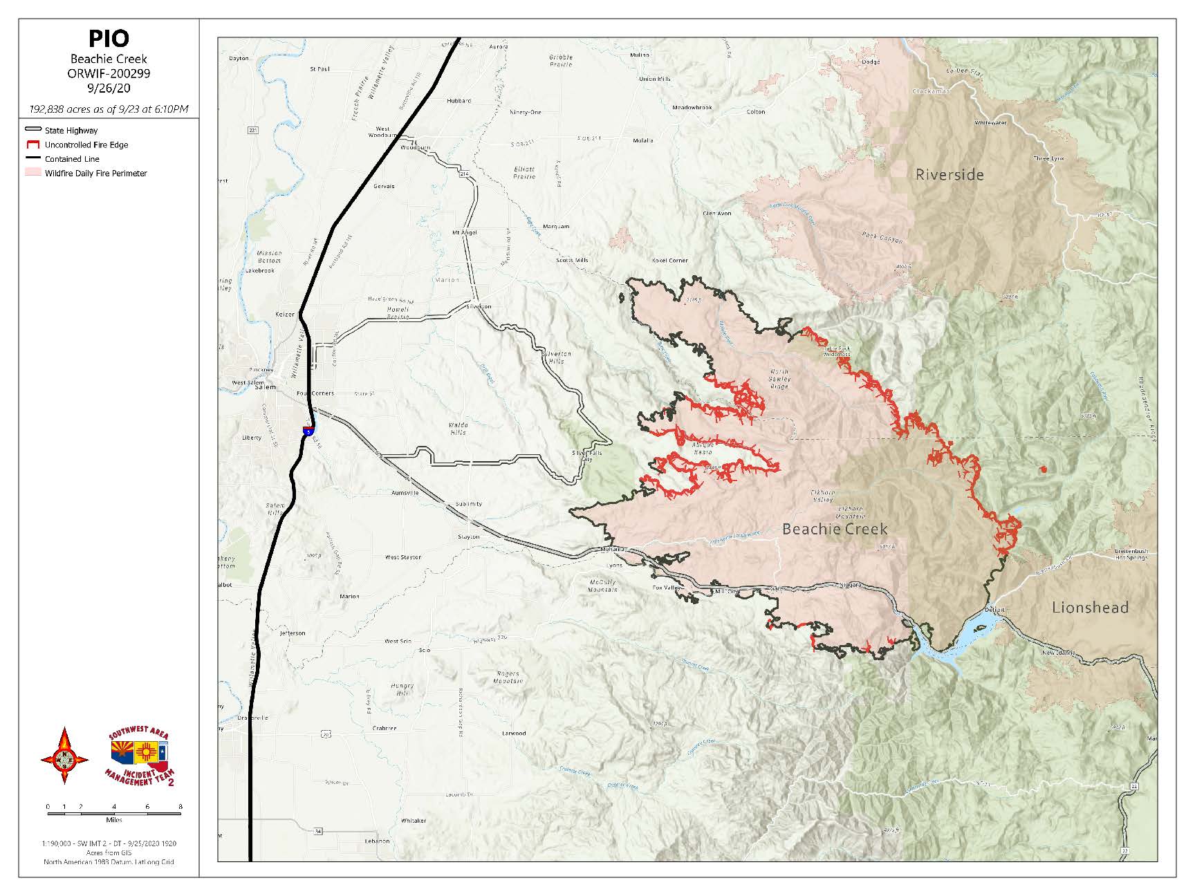
Beachie Creek Fire Update Saturday September 26 2020
Related Incident:
Publication Type: News
BEACHIE CREEK FIRE UPDATE – September 26, 2020
Acres: 192,838 acres Percent Containment: 52%
Start Date: August 16, 2020 Cause: Under Investigation
Origin Location: Opal Creek Wilderness: Fuels: Timber and logging slash
two miles south of Jawbone Flats, six Flights: Temporary Flight
miles north of Detroit, Oregon Restriction on east side
Resources: 677
Northern, Western, and Southern Flanks of Beachie Creek Fire Secure
Crews are working direct on the fire line and have contingency line in place
Salem, Ore. – Strong control lines are in place from the north, to the west and through the south of the Beachie Creek fire. Firefighters continue to monitor and secure lines.
On the northern fire flank, communities of Wilhoit, Scotts Mills, Silverton, Silverton hills, and Silver Falls State Park are protected. The western flank communities of Sublimity, Stayton, Mehama, Lyons and Fox Valley are secure. Evacuation levels for North Fork and Elkhorn are lowered. On the southern edge of the fire perimeter, the towns along Highway 22 of Mill City, Gates, Niagara, Detroit, and Idanha all have strong control lines. Crews continue to mop-up and patrol hot spots along all containment lines.
Smoldering is and will continue to be seen, but there is defensible space from those hot spots that protects the communities. Call 911 only if you see fire moving, not for smoke. Fire crews are already working the areas or purposely allowing interior fire to smolder; each 911 call takes them away from their task.
Crew assignments Saturday including working with the contracted timber company east of the Silver Falls State Park to clear hazard trees, weather permitting. Canadian crews are working along Highway 22. There is a crew dedicated to working with residents and any remaining debris. There are 677 fire responders working on the Beachie Creek fire. Yield to emergency vehicles and be aware of post-fire falling hazards.
Despite having a few days of rain, the fire is still creeping within the burn perimeter. It takes months of steady moisture to completely put the fire out. There are large areas of unburned and green trees that the fire jumped over during the wind event. On the ground, deep layers of organic material might be wet on top, yet fire burns deep underground. Off to the eastern flank, the fire is still burning in the Table Rock Wilderness where there are heavy and thick fuels that experience infrequent fire and exhibit drought-like conditions.
The Marion and Linn County Sherriff Offices continue to evaluate and lower evacuation levels; check updates on their websites:
Marion County Sherriff’s website / evacuation maps: https://marioncounty.maps.arcgis.com/apps/webappviewer/index.html?id=5202b602f99647b9a16d488c545113b5
Linn County Sheriff’s website here: https://linngis.maps.arcgis.com/apps/webappviewer/index.html?id=56668b1f57cf4bec9be88420a37e1183
The Willamette National Forest, Bureau of Land Management, and State lands around the fire remain closed to the public. Go to InciWeb.gov for more information about closures in the area. Public Contact Information:
Facebook.com/BeachieCreekFire2020
Email: 2020.beachiecreek@firenet.gov
Phone: 541-583-0526, 8 a.m. to 8 p.m.
Inciweb
https://inciweb.nwcg.gov/incident/7001/
Smoke and Air Quality http://oregonsmoke.blogspot.com/p/air quality-now.html
https://wildlandfiresmoke.net/outlooks
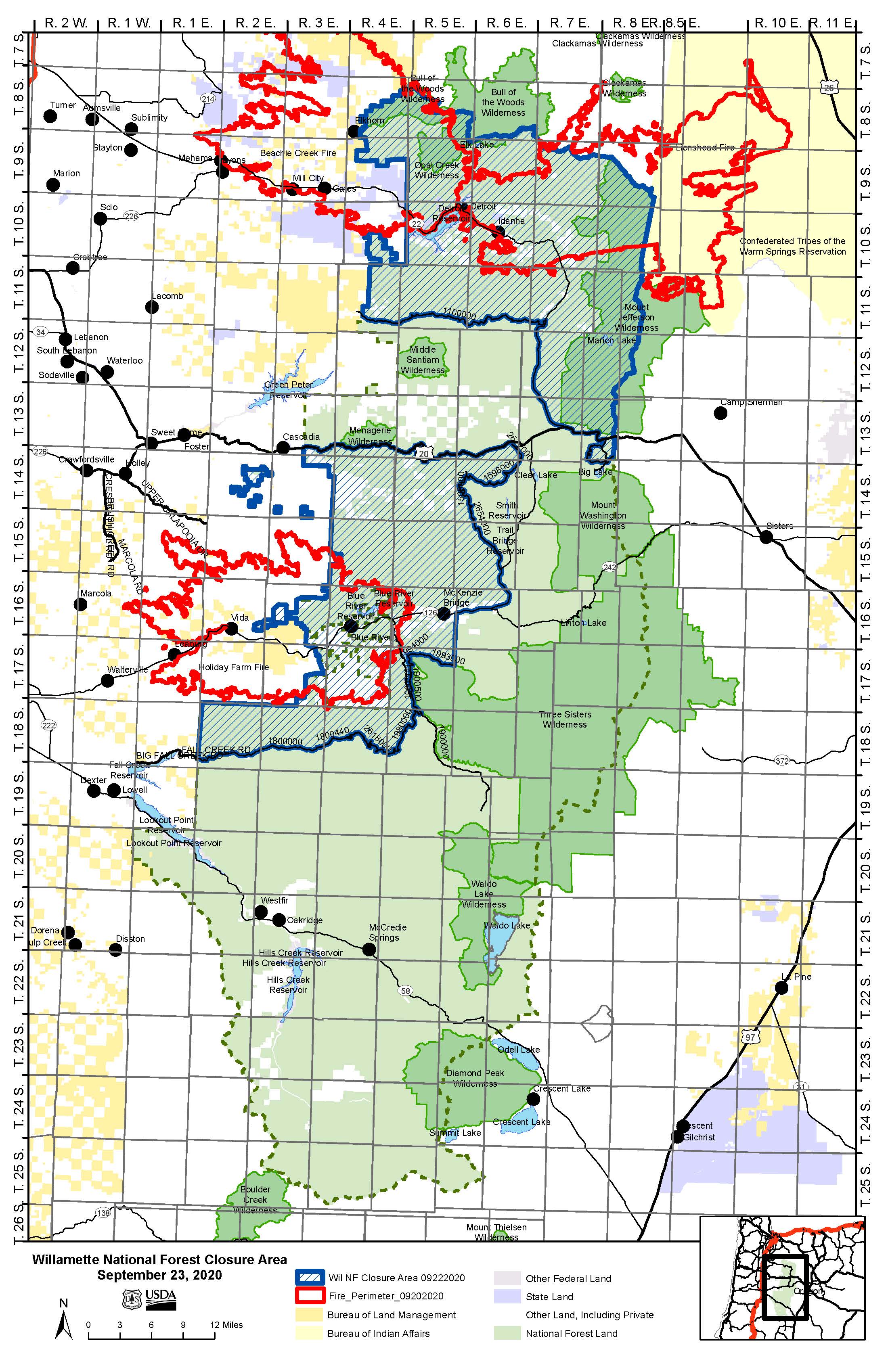
Willamette National Forest Closure Order 0618002021
Related Incident:
Publication Type: Closures
ORDER # 06-18-00-20-21
FOREST ORDER
OCCUPANCY AND USE
Pursuant to 16 USC 551 and 36CFR 261.50 (a) and (b), and to provide for public safety, the following acts are prohibited in the areas described in this order on National Forest System lands within the administrative boundaries of the Willamette National Forest. This Order is effective on September 25, 2020 and shall be in effect until rescinded or December 31, 2020, whichever comes first.
PROHIBITIONS:
1. Being on a road. 36 CFR § 261.54(e)
2. Being on a trail. 36 CFR § 261.55(a)
3. Entering or using a developed recreation site or portion thereof. 36 CFR § 261.58 (b)
4. Entering into or being upon National Forest System Lands closed for the protection of public health or safety. 36 CFR § 261.53(e)
CLOSURE DESCRIPTION:
All closures are contained within the State of Oregon, and Marion, Linn, and Lane Counties, and within the Administrative Boundaries of the Willamette National Forest.
The closure includes the US Forest Service general forest areas, developed recreation sites, roads, trails, and recreation residence tracts (aka "summer homes") as described below and as depicted on the attached map and incorporated into this order as "Attachment A".
The Holiday Farm Closure Area begins at the intersection of State Highway 126 and the Willamette National Forest Boundary west of McMullins Boat Ramp between Sections 1 and Section 2 in Township 17S Range 3E. It continues north following the Forest administrative boundary to its junction with State Highway 20. It continues east along the south side of Hwy 20 to its intersection with Forest Service Road 2672, then proceeds south along FSR 1598, incorporates FSR 1598, to its intersection with FSR 1500. It continues south along FSR 1500, incorporates FSR 1500, to its intersection with FSR 2654 (Deer Creek Road). It proceeds south along the east side of FSR 2654, and incorporates FSR 2654, to the intersection of FSR 2654 with Hwy 126. It then continues southwest along Hwy 126 for 8.1 miles to Section 13, T 16S, R 5E. It then proceeds south for 4.9 miles from Hwy 126 to FSR 1993, then west along the south side of FSR 1993, and incorporating FSR 1993, to the intersection with FSR 1994 on the east side of Cougar Reservoir, then continues to the intersection of FSR 1994 and FSR 1900-500, incorporating FSR 1994. It continues south on FSR 1900-500, incorporating FSR 1900-500, to its intersection with FSR 1900 and continues along the east side of FSR 1900, incorporating FRS
1900, to the intersection of FSR 1900 and FSR1980. It proceeds along the south and east sides of FSR 1980, incorporating FSR 1980, to the intersection with FSR 2618 at the northeast edge of Section 30, T 18S, R 5E. It continues west along the south side of FSR 2618, incorporating FSR 2618, to the intersection with FSR 2619 at the northwest corner of Section 23, T 18S, R 4E. It continues northwest along the west side of FSR 2619, incorporating FSR 2619, to the intersection with FSR 1800-440. It continues west along the south side of FSR 1800-440 to FSR 18. From there it continues west along the south side of FSR 18, incorporating FSR 18, to where it intersects the Forest boundary on the west side of Section 31, T 18S, R 2E. It then continues north along the Forest boundary for 5 miles to the northwest corner of Section 6, T 18S, R 2E. From there it continues east along the Forest boundary for 9.2 miles to the intersection with the McKenzie River Ranger District boundary in Section 34, T 17S, R 3E. It then follows the Forest administrative boundary 3 miles north to the northwest corner of Section 23, T 17S, R 3E, and then proceeds for 2.1 miles northeast to the Forest administrative boundary at the southwest corner of Section 1, T 17S, R 3E, and follows the National Forest Boundary north to end at the intersection with State Highway 126.
The Beachie Creek and Lionshead Closure Area begins at the junctions of Hwy 20 and Hwy 22 in Section 14, T 13S, R 7 E, and continues north along the east side of Hwy 22 to the intersection with FSR 11 on the south edge of Section 29, T 11S, R 7E. It proceeds west along the south side of FSR 11, and incorporates FSR 11, to the intersection with the Forest boundary in Section 28, T 11S, R 4E. It follows the Forest administrative boundary north to its intersection with Monument Peak Road in the northwest corner of Section 21, T 10S, R 4E, the follows the Forest administrative boundary southeast to Section 35, T 11S, R 4E, continues east along the Forest boundary to Section 31, T 10S, R 5E, and north along the Forest administrative boundary to the south edge of the Opal Creek Scenic Recreation Area at Section 12, T 9S, R 4E. It proceeds west and north along the Opal Creek Scenic Area boundary and then east along the Opal Creek Wilderness boundary until it meets the Bull of the Woods Wilderness boundary in Section 21, T 8S, R 5E. It then follows the Willamette National Forest administrative boundary south and east to the boundary with the Warm Springs Indian Reservation, and follows the Willamette National Forest administrative boundary south to its intersection with the Deschutes National Forest. It continues south along the Willamette National Forest boundary to its intersection with Hwy 20, crosses Hwy 20 and continues south along the Forest boundary to its intersection with FSR 2690-910, proceeds west along the south side of FSR 2690-910, incorporating FSR 2690-910, to its intersection with FSR 2690. It proceeds north on FSR 2690 to the intersection with FSR 2690-860 and then east along the south side of FSR 2690-860, incorporating FSR 2690-860, to its intersection with FSR 2690-818. It then proceeds north along the west side of FSR 2690-818, incorporates FSR 2690-818, to its intersection with FSR 2690-814. It then proceeds east along the north side of FSR 2690-814, incorporating FSR 2690-814, to its intersection with FSR 2690-805. It continues northeast along the west side of FSR 2690-805, and incorporates FSR 2690-805, to its intersection with FSR 2690. It continues north along the west side of FSR 2690, incorporating FSR 2690, to its intersection with Hwy 20, then proceeds west along the north side of Hwy 20 to end at the junction with Hwy 22.
National Forest System lands in the following isolated areas to the south of Hwy 20 are also included in the closure: the northeast quadrant of Section 31, T 14S, R 3E; the northeast and southwest quadrants of Section 26, T 14S, R 2E; the southwest quarter of the northeast quadrant and the southwest quadrant of Section 22, T 14S, R 2E; the southern half of the northeast quadrant and the southeast quarter of the northwest quadrant and the northeast quarter of the southwest quadrant in Section 21, T 14S, R 2E; the northeast quarter of the southeast quadrant of Section 15, T 14S, R 2E; the southern half of Section 11, T 14S, R 2E; the southwest quadrant of Section 12, T 14S, R 2E, and the southwest quarter of the northwest quadrant and the southeast quarter of the southeast quadrant also in Section 12, T 14S, R 2E.
EXEMPTIONS:
Pursuant to 36 CFR § 261.50 (e), the following persons are exempt from this Order:
(1) Any person with a permit specifically authorizing the otherwise prohibited act or omission;
(2) Owners or lessees of land in the area. Lessees of Recreation Residences (aka Summer Homes) inside the closure areas must have written permission specifically authorizing entry and identifying the person/address applicable.
(3) Any Federal, State, or Local Officer or member in the performance of an official duty.
These restrictions are implemented for the safety of the public.
This order supersedes Forest Order # 06-18-00-20-19 executed September 8, 2020, and supersedes Forest Order # 06-18-05-20-20 executed September 15, 2020.
These prohibitions are in addition to the general prohibitions in 36 CFR Part 261, Subparts A, B and C.
Executed in Springfield, Oregon on this 25 day of September, 2020.
___________________________
David Warnack
Forest Supervisor
Willamette National Forest
Violations of these prohibitions are punishable by a fine of not more than $5,000.00 for an individual or $10,000.00 for a corporation or imprisonment for not more than six months or both. Title 16 USC Section 551.
ACTUALIZACION DEL BEACHIE CREEK 25 de Septiembre 2020
Related Incident:
Publication Type: News
ACTUALIZACION DEL BEACHIE CREEK – 25 de Septiembre 2020
Acres: 192,838 acres Contención Porcentual: 52%
Fecha de Inicio: 16 de Agosto, 2020 Causa: Bajo Investigación
Ubicación de Origen: Opal Creek Wilderness: Combustibles: Madera y desechos de tala 2millas al sur de Jawbone Flats, Recursos: 755
6 millas norte de Detroit, Oregon. Vuelos: Restricción de Vuelo Temporal
El Viernes Trae Lluvias Empapadoras - Útil Para la Supresión de Incendio
Se Reducen Algunos Niveles de Evacuación
Salem, Ore. – El Incendio Beachie Creek recibió una pulgada de agua el Jueves en los perímetros norte y oeste. La cantidad de lluvia vareo en otros lugares - la precipitación penetrante lenta que es útil en la supresión de incendio. Con esta humedad, no hubo ningún crecimiento y tuvo mínima actividad dentro del perímetro del incendio. No se espera ningún crecimiento hoy.
La Oficina del Sheriff del Condado de Marion redujo algunos niveles de evacuación hoy. El viernes Los propietarios de casas y negocios serán escoltados por el Departamento de Transportación de Oregon en un horario pre-arreglado para entrar y salir de sus propiedades. La repoblación escoltada es para aquellos a lo largo del corredor de la Carretera 22 desde Lyon a Detroit y hasta Idanha. Los Oficiales de Información de Incendios estarán en el sitio en Detroit para contestar preguntas de los residentes. Los niveles de evacuación en North Fork y Elhorn se redujeron a 2.
Todas las comunidades desde el norte hasta el oeste y a lo largo del la Carretera 22 están seguras. A medida que los residente regresan después de ser evacuados, verán un mosaico negro en el suelo y arboles verdes que no se quemaron; no hay una línea solida de ceniza negra ni de arboles quemados; el incendio no ardió uniformemente a través del paisaje. Se llevarán muchos días para que los combatientes y equipo pesado conecten cada milla del paisaje ensamblado y características naturales para finalizar la línea de control. La comunidad de Detroit verá humo de troncos subterráneos cuales arden lentamente bien adentro del perímetro del incendio. Por favor no llamar al 911; los combatientes están conscientes de estos lugares y los están trabajando metódicamente.
Los socorristas continúan advirtiendo a los conductores sobre peligros posteriores del incendio. Los árboles comprometidos por el fuego pueden derrumbarse. Los combatientes están mitigando esos peligros alrededor de propiedades privadas. Las brigadas continúan asegurando, liquidando, y monitoreando el incendio. Para el viernes la mayor actividad de limpieza es al este del Parque Nacional Silver Falls. El incendio aun contiene calor profundo en Table Top Wilderness.
Las Oficinas del Sheriff del los Condados Marion y Linn continúan evaluado y reduciendo los niveles de evacuación; revise las actualizaciones en sus sitios-de-web:
Marion County Sheriff’s sitio-de web /mapas de evacuaciones: https://marioncounty.maps.arcgis.com/apps/webappviewer/index.html?id=5202b602f99647b9a16d488c545113b5
Linn County Sheriff’s sitio-de-web: https://linngis.maps.arcgis.com/apps/webappviewer/index.html?id=56668b1f57cf4bec9be88420a37e1183
El Bosque Nacional Willamette, Bureau of Land Management y Tierras Estatales alrededor del incendio permanecen cerrados al público. Visite InciWeb.gov para más información sobre áreas cerradas en la zona.
Información de Contacto Publica:
Facebook.com/BeachieCreekFire2020
Email: 2020.beachiecreek@firenet.gov
Teléfono: 541-583-0526, 8 a.m. to 8 p.m.
Inciweb
https://inciweb.nwcg.gov/incident/7001/
Smoke and Air Quality http://oregonsmoke.blogspot.com/p/air-quality-now.html
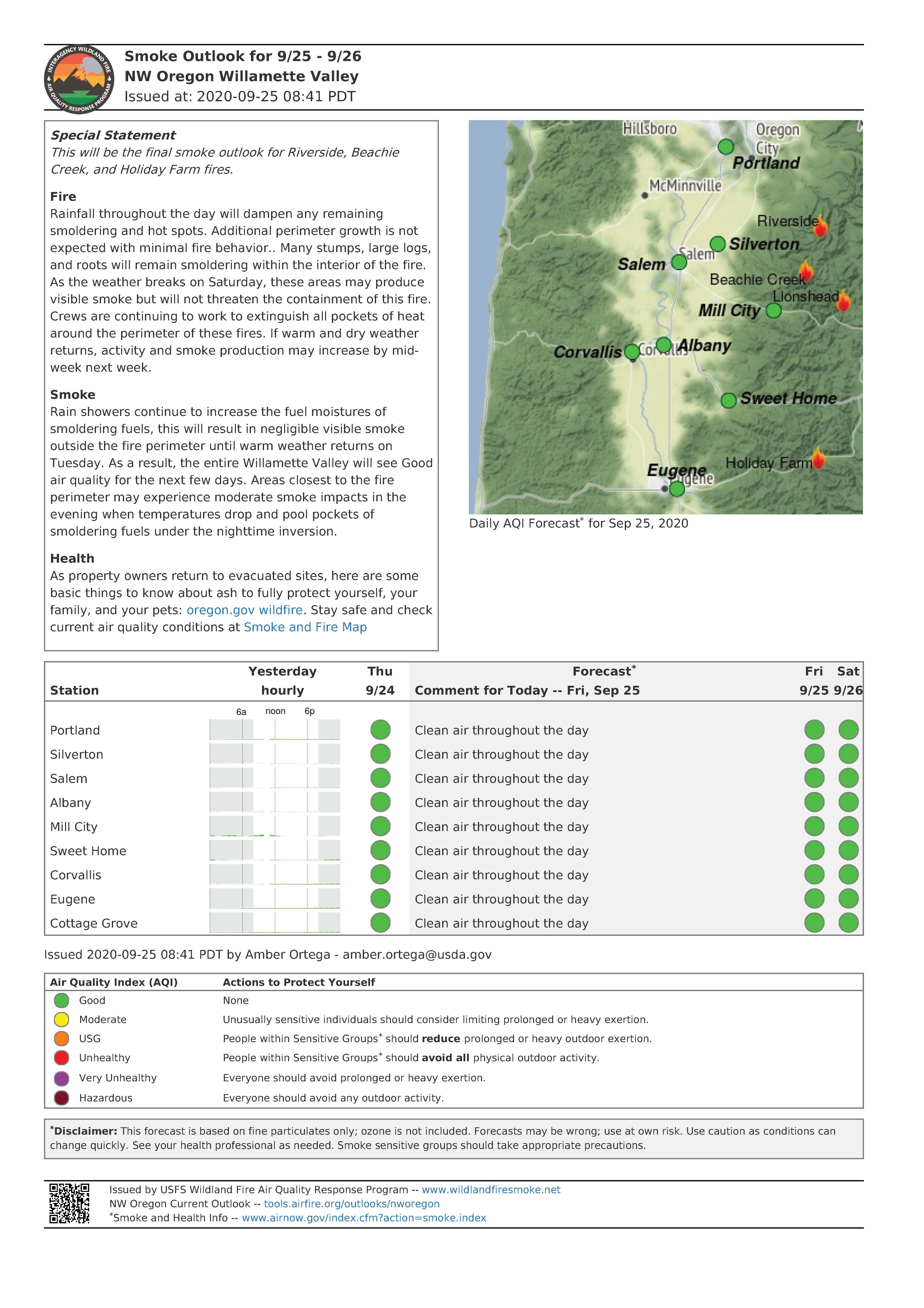
Smoke Outlook for NW Oregon Willamette Valley Friday Sept 25
Related Incident:
Publication Type: Announcement
Special Statement
This will be the final smoke outlook for Riverside, Beachie
Creek, and Holiday Farm fires.
Fire
Rainfall throughout the day will dampen any remaining
smoldering and hot spots. Additional perimeter growth is not
expected with minimal fire behavior.. Many stumps, large logs,
and roots will remain smoldering within the interior of the fire.
As the weather breaks on Saturday, these areas may produce
visible smoke but will not threaten the containment of this fire.
Crews are continuing to work to extinguish all pockets of heat
around the perimeter of these fires. If warm and dry weather
returns, activity and smoke production may increase by midweek
next week.
Smoke
Rain showers continue to increase the fuel moistures of
smoldering fuels, this will result in negligible visible smoke
outside the fire perimeter until warm weather returns on
Tuesday. As a result, the entire Willamette Valley will see Good
air quality for the next few days. Areas closest to the fire
perimeter may experience moderate smoke impacts in the
evening when temperatures drop and pool pockets of
smoldering fuels under the nighttime inversion.
Health
As property owners return to evacuated sites, here are some
basic things to know about ash to fully protect yourself, your
family, and your pets: oregon.gov wildfire. Stay safe and check
current air quality conditions at Smoke and Fire Map
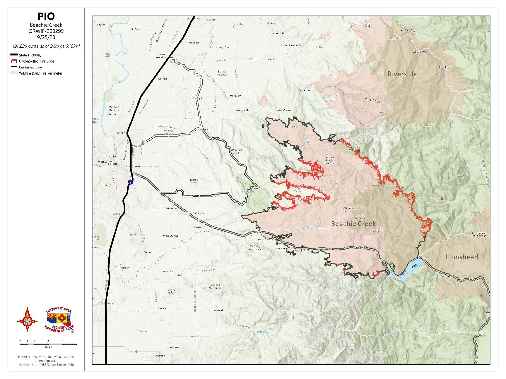
Beachie Creek Fire Update Friday September 25 2020
Related Incident:
Publication Type: News
BEACHIE CREEK FIRE UPDATE – September 25, 2020
Acres: 192,838 acres Percent Containment: 52%
Start Date: August 16, 2020 Cause: Under Investigation
Origin Location: Opal Creek Wilderness: Fuels: Timber and logging slash
two miles south of Jawbone Flats, Resources: 755
six miles north of Detroit, Oregon. Flights: Temporary Flight Restriction
Friday Brings Soaking Rains – Helpful in Fire Suppression
Some Evacuation Levels Lowered
Salem, Ore. – The Beachie Creek fire received an inch of rain Thursday over the north and west perimeters. Rainfall amounts varied elsewhere. Friday brings soaking rains – the slower penetrating precipitation that’s helpful in fire suppression. With this moisture, there was no new fire growth and minimal activity from within the fire boundary. No growth is anticipated today.
The Marion County Sheriff’s Office lowers some evacuation levels today. Home and business owners will be escorted by the Oregon Department of Transportation on a pre-arranged schedule in to and out of their properties Friday. The escorted repopulation is for those along the Highway 22 corridor from Lyons to Detroit and on to Idanha. Fire Information Officers will be on site in Detroit Friday to answer questions for residents. The North Fork and Elkhorn evacuation levels are lowered to 2.
All communities from the north to the west and along Highway 22 are secure. As residents return after evacuation, they will see a mosaic of blackened ground and unburned green trees; there is not a solid line of black ash or burned trees; the fire did not burn evenly across the landscape. It will take many days for firefighters and heavy equipment to connect every mile of montaged landscape and natural features for final control lines. The Detroit community will see smoke from smoldering tree stumps deep underground and well within the fire boundary. Please do not call 911; firefighters are already aware of these locations and methodically working them.
First responders continue to caution drivers and residents about post-fire hazards. Trees compromised by fire could topple. Firefighters are mitigating those hazards around private property. Crews continue to secure, mop up, and monitor the fire. Most clearing activity Friday is east of the Silver Falls State Park. The fire still contains heat deep in the Table Top Wilderness.
The Marion and Linn County Sherriff Offices continue to evaluate and lower evacuation levels; check updates on their websites:
Marion County Sherriff’s website / evacuation maps: https://marioncounty.maps.arcgis.com/apps/webappviewer/index.html?id=5202b602f99647b9a16d488c545113b5
Linn County Sheriff’s website here: https://linngis.maps.arcgis.com/apps/webappviewer/index.html?id=56668b1f57cf4bec9be88420a37e1183
The Willamette National Forest, Bureau of Land Management, and State lands around the fire remain closed to the public. Go to InciWeb.gov for more information about closures in the area.
Public Contact Information:
Facebook.com/BeachieCreekFire2020
Email: 2020.beachiecreek@firenet.gov
Phone: 541-583-0526, 8 a.m. to 8 p.m.
Inciweb
https://inciweb.nwcg.gov/incident/7001/
Smoke and Air Quality http://oregonsmoke.blogspot.com/p/air-quality-now.html
ACTUALIZACION DEL INCENDIO BEACHIE CREEK 24 de Septiembre 2020
Related Incident:
Publication Type: News
ACTUALIZACION DEL INCENDIO BEACHIE CREEK – 24 de Septiembre , 2020
Acres: 192,838 acres Contención Porcentual : 49%
Fecha de Inicio: 16 de Agosto, 2020 Causa: Bajo Investigación
Ubicación de Origen: Opal Creek Wilderness: Combustibles: Madera y desechos de tala
2 millas al sur de Jawbone Flats, Recursos: 801
6 millas norte de Detroit, Oregon. Vuelos: Restricción de Vuelo Temporal
No hay expansión en el Incendio Beachie Creek
La Lluvia detiene la actividad del fuego el Jueves
Salem, Ore. – El Incendio Beachie Creek responderá favorablemente a la continua precipitación. La cobertura pesada de nubes, la alta humedad y las lluvias detienen la actividad del fuego, y disminuyen el humo.
Las condiciones húmedas también pueden causar peligros en los próximos días. Conductores deben reconocer y estar conscientes de que existen numerosos peligros de conducción en ambos ambientes urbanos y rurales. Ceda el paso a los socorristas. A medida que aumenta la humedad en el suelo, arboles debilitados por el incendio pueden derrumbarse, y también son posibles deslizamientos de rocas y lodo.
No hubo expansión del perímetro del incendio el Miércoles, , aunque aún permanecen fuentes de calor adentro del perímetro. El incendio ha estado ardiendo lentamente por debajo quemando raíces de los árboles y creando posos de hasta 7 pulgadas de profundidad llenos de ceniza caliente que llegan hasta 1,200 grados. En estos lugares, las brigadas trabajaron el Miércoles para exponer estas profundas fosas de ceniza para que hoy la lluvia pueda penetrar el calor, pero se llevara lluvia constante durante largos periodos para ponerle fin al incendio.
Después de evaluar los peligros, las brigadas ajustaran su nivel de compromiso directo debajo de los árboles. El Jueves la mayoría del trabajo se llevará a cabo a lo largo del corredor de la Carretera 22 donde los combatientes monitorearán el fuego y reducirán los peligros para los residentes. Una brigada que está dedicada a proteger estructuras también continuara trabajando en las áreas de North Santiam River y Elkhorn. Contratistas de madera están asegurando una línea de control sin quemar en el área de 14 millas al este del Parque Estatal Silver Falls.
Las Oficinas del Sheriff de los Condados Marion y Linn continuar evaluado y bajando los niveles de evacuación pero les piden a los residentes que se mantengan conectados con sus sitios-de-web y alertas:
• Marion County Sheriff’s sitio-de-web / mapas de evacuaciones: https://marioncounty.maps.arcgis.com/apps/webappviewer/index.html?id=5202b602f99647b9a16d488c545113b5
• Linn County Sheriff’s sitio-de-web aquí: https://linngis.maps.arcgis.com/apps/webappviewer/index.html?id=56668b1f57cf4bec9be88420a37e1183
El Bosque Nacional Willamette, Bureau of Land Management y Tierras Estatales alrededor del incendio permanecen cerrados al público. Visite InciWeb.gov para más información sobre áreas cerradas en la zona. Información de Contacto Pública:
Facebook.com/BeachieCreekFire2020
Email: 2020.beachiecreek@firenet.gov
Teléfono: 541-583-0526, 8 a.m. to 8 p.m.
Inciweb
https://inciweb.nwcg.gov/incident/7001/
Smoke and Air Quality http://oregonsmoke.blogspot.com/p/air-quality-now.html
https://wildlandfiresmoke.net/outlooks
Marion County Evacuation Level Update
Related Incident:
Publication Type: Announcement
Tomorrow morning, September 25th, 2020, at 9 a.m. evacuation level changes will go into effect in Marion County.
The changes are being made following careful consultation with fire management officials, the Oregon Department
of Transportation, Marion County Public Works, and many other partner agencies.
The cities of Detroit, Idanha and the Elkhorn community along North Fork Road will be reduced to a Level 2 – “Be
Set” evacuation level. Crews have been working tirelessly to restore access to evacuated areas. While residents
will be able to return to these communities, many hazards remain and core services have not been restored to
residences.
Detroit/Idanha Access Using Pilot Cars:
The Oregon Department of Transportation is working with multiple contractors to remove hazardous trees and
debris along OR 22E between mile post 33, in Gates, and mile post 65, near Marion Forks. To allow residents
access to the cities of Detroit and Idanha, ODOT will be using pilot cars to lead residents through the closed
sections of OR 22E between Gates and Detroit. Residents may travel freely between Detroit and Idanha with OR
22E closed to eastbound traffic at mile post 56.2, west of Cooper’s Ridge Rd.
There is no through access to the Santiam Pass from the Detroit/Idanha area at this time. Tree removal in the area
between Gates and Detroit will cause delays for the inbound and outbound pilot car trips. Residents should expect
at least one hour to make a one-way trip. Pilot cars guiding residents between Gates and Detroit will be limited to
the following daily schedule:
· 9 a.m. – Pilot car departs Gates to Detroit
· 11 a.m. – Pilot car returns from Detroit to Gates
· 1 p.m. – Pilot car departs Gates to Detroit
· 5 p.m. – Pilot car returns from Detroit to Gates
“As our residents return to the cities of Detroit and Idanha, we are asking the media and other visitors to be
respectful of our community members during this difficult time,” City of Detroit Mayor Jim Trett. “This will be the
first time many of our residents are seeing the extent of the damage following the wildfires. Please allow our
residents an opportunity to grieve these losses privately.”
Due to the remaining hazards in the cities of Detroit and Idanha and lack of basic services, we request people nonresidents
of Detroit and Idanha to refrain from traveling to this area. The Marion County Sheriff’s Office continues
to coordinate with partner law enforcement agencies to maintain an enhanced presence in the Detroit and Idanha
communities as residents return to the area.
North Fork Rd / Elkhorn:
The North Fork Road corridor will be reduced to a Level 2 – “Be Set” status up to the boundary with U.S. Forest
Service property, near mile post 15.5. Some roadways will remain closed to traffic by Marion County Public
Works while trees are removed and damaged culverts and roadways can be repaired:
· Gates Hill Road between North Fork Rd and OR 22E
· North Fork Rd east of Gates Hill Road
Numerous fire damaged trees remain near roadways and properties. These trees may fall at any time. Power has
not yet been restored to the North Fork area. We urge residents to remain vigilant and be prepared encounter
downed trees on the road.
· Watch out for falling rocks and debris in the roadway.
· Do not approach downed power lines.
· Drive slowly! Be watchful for personnel working in the roadway as road cleanup and utility repairs are still
ongoing.
· Keep a safe distance from septic tanks and other buried structures that may have been damaged in the fire.
· All county parks located within the fire zone are closed.
· Comply with roadway signs and instructions provided by road crews, utility workers and law enforcement.
· Keep dogs on leashes, many hazards exist which may be harmful to animals.
The Willamette National Forest remains closed to the public at this time, updates can be found at
https://www.fs.usda.gov/willamette/.
Wildfire Ash & Debris
Remediation of property destroyed or damaged by wildfire can be dangerous and should be approached with
caution. There are special requirements for transporting and disposing of wildfire debris. For more information
about debris removal see the attachment from Marion County Environmental Services.
Evacuation levels for communities in Marion County as of 9:00 am on September 25th, 2020:
Level 3 – “Go”
Breitenbush
Crooked Finger Rd south of the cattle guard
Level 2 – “Be Set”
Detroit
Idanha
OR 22E between mile post 33 to 59.5, west of Cooper’s Ridge Road
Level 1 – “Ready”
Mill City
Gates
Lyons
Mehama
The evacuation map for Marion County will be updated at 9 a.m., September 25th, 2020, to reflect the updated
evacuation levels. The evacuation map and resources for community members impacted by the recent wildfires can
be found on the Marion County website at www.co.marion.or.us/fire.
Community members who happen to reside in Linn County may find up to date information at
www.LinnSheriff.org.
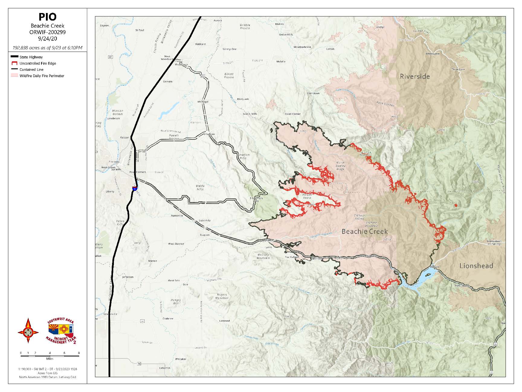
Beachie Creek Fire Update Thursday September 24 2020
Related Incident:
Publication Type: News
BEACHIE CREEK FIRE UPDATE – September 24, 2020
Acres: 192,838 acres Percent Containment: 49%
Start Date: August 16, 2020 Cause: Under Investigation
Origin Location: Opal Creek Wilderness: Fuels: Timber and logging slash
two miles south of Jawbone Flats, Resources: 801
six miles north of Detroit, Oregon. Flights: Temporary Flight Restriction
No expansion of the Beachie Creek fire
Rain slows fire activity Thursday
Salem, Ore. – The Beachie Creek fire will respond favorably to the continued rainfall. Heavy cloud cover, high humidity, and showers slow fire activity and subside smoke.
Wet conditions can also cause dangers in the coming days. Drivers must recognize and be aware that there are numerous hazards present in both urban and rural driving environments. Yield to first responders. As ground moisture increases, fire-weakened trees could topple, and rock and mudslides are possible.
There was no expansion of the fire perimeter on Wednesday, though heat sources remain inside of the boundary. Fire has been smoldering underground burning tree roots and creating cavities filled with hot ash as deep as seven inches and a hot as 1,200 degrees. At these locations, crews worked Wednesday to expose the deep ash pits so today’s rain can penetrate the heat, but it will take steady rain over long periods to end the fire.
After assessing hazards, crews will adjust their level of direct engagement under trees. Most work on Thursday will occur along the Highway 22 corridor where firefighters will monitor the fire and mitigate hazards for residents. A crew dedicated to protecting structures will also continue working in the North Santiam River and Elkhorn areas. Timber contractors are securing a control line in the 14-mile unburned area to the east of Silver Falls State Park.
The Marion and Linn County Sherriff Offices continue to evaluate and lower evacuation levels but are asking residents to stay connected with their websites and alerts:
· Marion County Sherriff’s website / evacuation maps: https://marioncounty.maps.arcgis.com/apps/webappviewer/index.html?id=5202b602f99647b9a16d488c545113b5
· Linn County Sheriff’s website here: https://linngis.maps.arcgis.com/apps/webappviewer/index.html?id=56668b1f57cf4bec9be88420a37e1183
The Willamette National Forest, Bureau of Land Management, and State lands around the fire remain closed to the public. Go to InciWeb.gov for more information about closures in the area.
Public Contact Information:
Facebook.com/BeachieCreekFire2020
Email: 2020.beachiecreek@firenet.gov
Phone: 541-583-0526, 8 a.m. to 8 p.m.
Inciweb
https://inciweb.nwcg.gov/incident/7001/
Smoke and Air Quality http://oregonsmoke.blogspot.com/p/air-quality-now.html
https://wildlandfiresmoke.net/outlooks
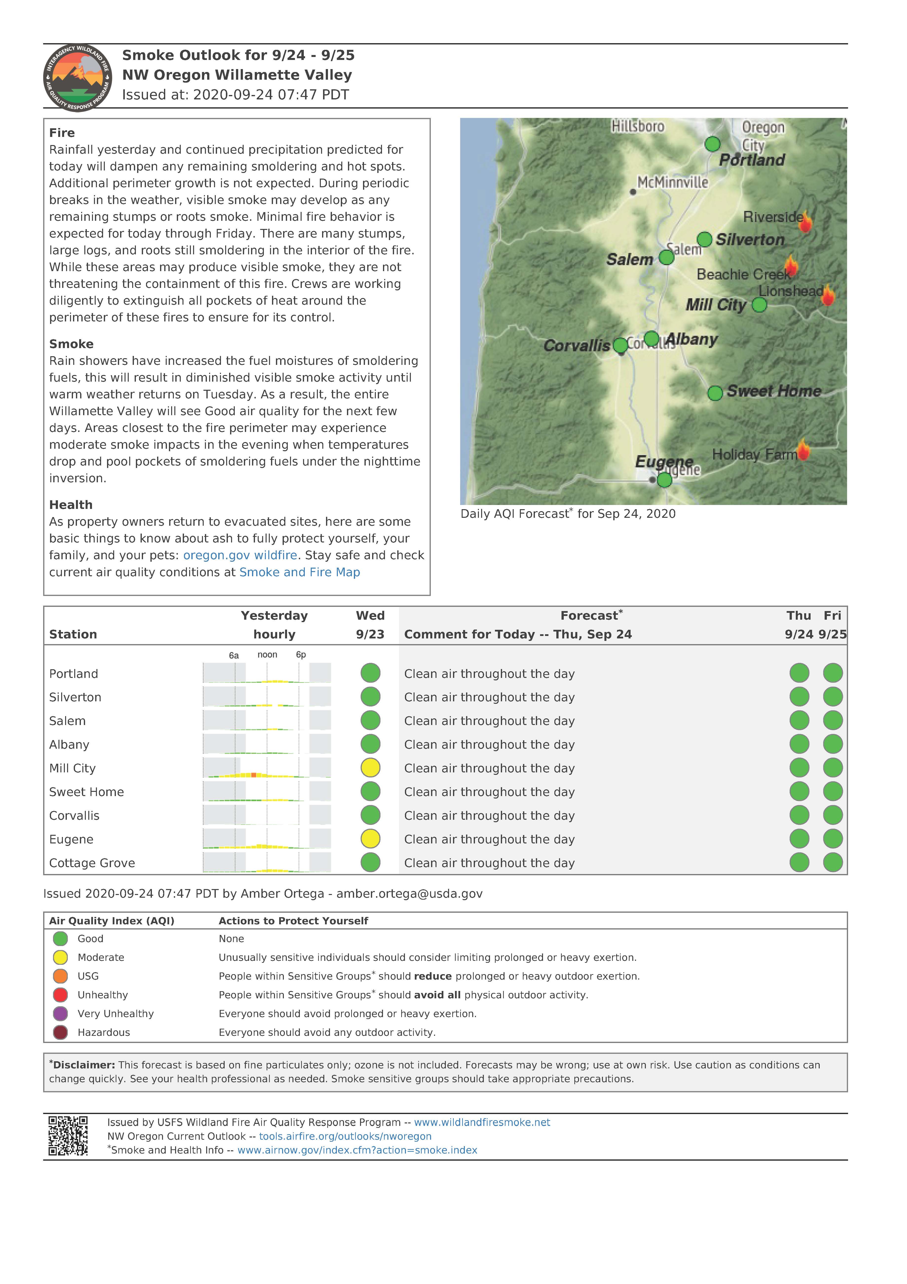
Smoke Outlook for NW Oregon Willamette Valley Thursday Sept 24
Related Incident:
Publication Type: Announcement
Fire
Rainfall yesterday and continued precipitation predicted for today will dampen any remaining smoldering and hot spots. Additional perimeter growth is not expected. During periodic breaks in the weather, visible smoke may develop as any remaining stumps or roots smoke. Minimal fire behavior is expected for today through Friday. There are many stumps, large logs, and roots still smoldering in the interior of the fire. While these areas may produce visible smoke, they are not threatening the containment of this fire. Crews are working diligently to extinguish all pockets of heat around the perimeter of these fires to ensure for its control.
Smoke
Rain showers have increased the fuel moistures of smoldering fuels, this will result in diminished visible smoke activity until warm weather returns on Tuesday. As a result, the entire Willamette Valley will see Good air quality for the next few days. Areas closest to the fire perimeter may experience moderate smoke impacts in the evening when temperatures drop and pool pockets of smoldering fuels under the nighttime inversion.
Health
As property owners return to evacuated sites, here are some basic things to know about ash to fully protect yourself, your family, and your pets: oregon.gov wildfire. Stay safe and check current air quality conditions at Smoke and Fire Map
ACTUALIZACION DEL INCENIO BEACHIE CREEK23 DE SEPTIEMBRE 2020
Related Incident:
Publication Type: News
ACTUALIZACION DEL INCENIO BEACHIE CREEK–23 DE SEPTIEMBRE, 2020
Acres: 192,828 acres Contención Porcentual: 46%
Fecha de Inicio: 16 de Agosto, 2020 Causa: Bajo Investigación
Ubicación de Origen: Opal Creek Wilderness: Combustibles: Madera y desechos de tala
2 millas al sur de Jawbone Flats, Recursos: 800
6 norte de Detroit, Oregon. Vuelos: Restricción de Vuelo Temporal
Muy Poco Crecimiento en el Incendio Beachie Creek
Combatientes y el Público Vigilar por Árboles Cayéndose el Miércoles
Salem, Ore. – Un frente frio fuerte empuja sobre el Valle de Willamette el Miércoles trayendo vientos sostenibles de 20 millas por hora y ráfagas de hasta 45. El incendio ha tenido mínimo crecimiento y poco se espera. La mayor preocupación de hoy es el viento que puede tumbar arboles debilitados y quemados y quebrar ramas grandes. El Equipo de Manejo de Incidentes aconseja los residentes que vean hacia arriba, a su alrededor y estén conscientes de estos peligros.
Fuertes lluvias llegaran el Miércoles por la tarde y Jueves. Esto asistirá a los esfuerzos de combate; pero, la humedad adicional puede causar deslizamientos de rocas y lodo en pendientes inclinados. El lado norte del incendio está completamente cerrado a través del área del Rio Molalla donde es probable que existan escombros caídos después de la quema severa del lugar. Esta mañana se instalará una cerca temporal en el camino Molalla cerca del camino Trout Creek para ayudar a restringir el acceso al público al área del incendio. En Butte Creek y muy adentro del perímetro, el fuego está ardiendo lentamente hacia bajo de un pendiente cual está protegido por el viento. En el borde oeste del incendio, una compañía de madera esta contratada para utilizar equipo pesado para limpiar la vegetación y construir una línea de control de 20-millas en Abiqua Creek. Existe un línea de control secundaria establecida para proteger el área de Silver Falls. Los bordes del norte y oeste están asegurados.
A lo largo del corredor de la Carretera 22, de Lyons, Mill City, hasta Gates, 115 combatientes Canadienses y 18 motobombas están haciendo gran progreso construyendo línea de fuego, destruyendo áreas calientes y troncos ardiendo lentamente. Combatientes están mitigando los peligros al norte de Gates en las área de Elk Horn / North Fork cual aún permanecen cerradas. Al sur de la Carretera 22, las brigadas están mejorando el espacio defendible en el área de Rock Creek. A través del perímetro del incendio, existe una Restricción de Vuelo Temporal cual fue violada el Martes por 2 aeronaves y un parapente. Los vuelos de aeronaves de combate se cancelan cuando el publico viola la Restricción de Vuelo Temporal establecida.
El Equipo de Manejo de Incidentes se preparo para el sistema del tiempo atmosférico de hoy. No será como el evento del Dia de Trabajo. Las Oficinas del Sheriff de los Condados Marion y Linn continúan evaluando y reduciendo los niveles de evacuación pero les piden a los residentes que se mantengan conectados con sus sitios-de-web y alertas:
Marion County Sherriff’s website / mapas de evacuaciones: https://marioncounty.maps.arcgis.com/apps/webappviewer/index.html?id=5202b602f99647b9a16d488c545113b5
Linn County Sheriff sitio-de-web aquí: https://linngis.maps.arcgis.com/apps/webappviewer/index.html?id=56668b1f57cf4bec9be88420a37e1183
El Bosque Nacional Willamette, Bureau of Land Management y Tierras Estatales alrededor del incendio permanecen cerrados al público. Visite InciWeb.gov para más información sobre áreas cerradas en la zona.
Información de Contacto Publica: Facebook.com/BeachieCreekFire2020 Email: 2020.beachiecreek@firenet.gov Teléfono: 541-583-0526, 8 a.m. to 8 p.m. Inciweb https://inciweb.nwcg.gov/incident/7001/ Smoke and Air Quality http://oregonsmoke.blogspot.com/p/air-quality-now.html https://wildlandfiresmoke.net/outlooks