
Forest Order 05132031 SQF Complex Fire Area Road and Trail Closure
Related Incident:
Publication Type: Closures
FOREST ORDER NO. _0513-20-31
SEQUOIA NATIONAL FOREST GIANT SEQUOIA NATIONAL MONUMENT
WESTERN DIVIDE AND KERN RIVER RANGER DISTRICTS SQF COMPLEX FIRE AREA, ROADS, AND TRAILS CLOSURE
Pursuant to 16 U.S.C. 551 and 36 C.F.R. 261.50(b), and to provide for public safety, the following acts are prohibited within the Western Divide Ranger District of the Sequoia National Forest. This Forest Order is effective from August 26, 2020, through September 30, 2020.
1. Going into or being upon National Forest System lands within the SQF Complex Fire Closure Area, as described in Exhibit A and shown on Exhibit B.
36 C.F.R. 261.53(e).
2. Being on the National Forest System trails within the SQF Complex Fire Closure Area as shown on Exhibit B. 36 C.F.R. 261.55(a).
3. Being on the National Forest System roads within the SQF Complex Fire Closure Area as shown on Exhibit B. 36 C.F.R. 261.54(e).
Pursuant to 36 C.F.R. 261.50(e), the following persons are exempt from this Order:
1. Persons with Forest Service Permit No. FS-7700-48 (Permit for Use of Roads, Trails, or Areas Restricted by Regulation or Order), specifically exempting them from this Order.
2. Any Federal, State, or local officer, or member of an organized rescue or fire fighting force in the performance of an official duty.
3. Owners or lessees of land, within the SQF Complex Fire Closure Area to the extent necessary to access their land.
4. Residents, within SQF Complex Fire Closure Area to the extent necessary to access their residences.
A violation of these prohibitions is punishable by a fine of not more than $5,000 for an individual or $10,000 for an organization, or imprisonment for not more than six months, or both.
16 U.S.C. 551 and 18 U.S.C. 3559, 3571, and 3581.

Executed in Porterville, California, this 25th day of August, 2020.
TERESA BENSON
Forest Supervisor Sequoia National Forest
ORDER NO. 0513-20-31
SEQUOIA NATIONAL FOREST
WESTERN DIVIDE AND KERN RIVER RANGER DISTRICTS SQF COMPLEX FIRE AREA, TRAIL AND ROAD CLOSURE EXHIBIT A
The boundary of the SQF Complex Fire Closure Area begins at the intersection of the Golden Trout Wilderness boundary and Touhy Gap Trail (Forest Trail No. 30E13) in Section 1, Township 19 South, Range 30 East, MDB&M, then continues northeast approximately 32.8 miles along the Golden Trout Wilderness boundary to its intersection with the forest boundary in Section 21, T.18S., R.33E., MDB&M, then continues southeast approximately 18.3 miles along the forest boundary to its intersection with Blackrock Road (Forest Road No. 21S03) in the northwest corner of Section 23, T.20S., R.34E., MDB&M, then continues south approximately 8.5 miles along the Blackrock Road to its intersection with the Sherman Pass Road (Forest Road No. 22S05) in the southwest corner of Section 13, T.21S., R.34E., MDB&M, then continues southwest approximately 31.6 miles along the Sherman Pass Road to its intersection with Sierra Highway (County Road Mountain 99) in Section 35, T.22S., R.32E., MDB&M, then continues north approximately 1.5 miles along Sierra Highway to its intersection with Elephant Knob Trail (Forest Trail No. 32E43) in the northwest corner of Section 35, then continues approximately 1.9 miles along Elephant Knob Trail to its intersection with Dry Meadow Road (Forest Road No. 22S53) in Section 22, then continues approximately 1.6 miles along Dry Meadow Road to its intersection with Lloyd Meadow Road (Forest Road No. 22S82) in the northwest corner of Section 22, then continues approximately 14.9 miles along Lloyd Meadow Road to its intersection with Freeman Creek Trail (Forest Trail No. 32E20) in Section 34, T. 20 S., R.32E., MDB&M, then continues west along Freeman Creek Trail approximately 4.2 miles to its intersection with North Road (Forest Road No. 21S50) in Section 5, T.21 S., R. 32 E., MDB&M, then continues north along North Road approximately 9.3 miles to its intersection with the Golden Trout Wilderness in Section 1, T. 20 S., R. 31 E., MDB&M, then continues northwest approximately 16.4 miles along the boundary of the Golden Trout Wilderness boundary to the starting point, as shown on Exhibit B.
Castle Fire grows to 5000 acres voluntary evacuation order issued
Related Incident:
Publication Type: News
SPRINGVILLE, CALI. August 24, 2020 - The Castle Fire on the Western Divide Ranger District, northeast of the mountain community of Ponderosa, has grown to approximately 5,000 acres. The fire continues to move further into the Golden Trout Wilderness on the Sequoia National Forest and is advancing towards the Inyo National Forest.
Today, Tulare County Sheriff Mike Boudreaux issued a voluntary evacuation notice for the areas of Camp Nelson and Ponderosa. Tulare County Sheriff Office (TCSO) Deputies are going cabin to cabin, letting people know that the fire is growing, and it would be a good idea to leave.
A Forest Closure Order of the Golden Trout Wilderness trails and trailheads is pending. As the fire continues to advance further into the Golden Trout Wilderness, hikers are asked not to enter the area.The Forest Service is planning a community meeting at Camp Nelson for Tuesday, Aug 25 at 6 pm. More details and location will be announced in tonight’s evening fire update.
Hazardous conditions for firefighters include steep rocky terrain and heavy fuel loads, 100-degree temperatures, erratic fire behavior due to intense afternoon winds. Hand crews, supported by aircraft, are working to stop the fire spread. Several resources are on order to support the firefight for this incident, but availability is limited due to other fires. The Forest is prioritizing firefighting resources to protect life first and then property and infrastructure.
California Interagency Incident Management Team 12 assumed command of the Castle and Shotgun fires, Monday, August 24. The team brings operational leadership, planning group, logistical support, and communications to augment the Forest and impacted communities.
Smoke and widespread air quality impacts from the California wildfires remain the primary weather concern. Additional lightning and thunderstorms are predicted this week, and in response, the Forest is using a combination of fire lookouts, patrols, and aerial detection to search for new fire starts. Visitors are urged to be vigilant about wildfire prevention as hot and dry weather conditions remain throughout the week.
Also, the Shotgun Fire, located where Pistol Creek and Shotgun Creek converge in the Golden Trout Wilderness, has grown to approximately 200 acres.
Visitors to the Forest will continue to see smoke, active fire, and firefighters during the next few days. Please drive slowly and carefully. For information about air quality, smoke conditions, and health effects, visit www.valleyair.org or visit www.airnow.gov.
For More Information: Hours of Operation: 7 a.m. - 9 p.m. Inciweb: https://inciweb.nwcg.gov/incident/6881/ Facebook: facebook.com/SequoiaNFTwitter: @sequoiaforest Fire Info Line: 661-432-2230Email: 2020.castlefire@gmail.com
Trail and Trailhead Closures in the Golden Trout Wilderness
Related Incident:
Publication Type: Closures
All trailheads and trails leading into the Golden Trout Wilderness from the Sequoia National Forest are in the process of being closed to public entry under a Forest Closure Order due to the Fires. Several Wilderness travelers have been evacuated from the Trout Meadow area. Permit holders for future trips into the Wilderness have been notified.
Castle Fire grows and second lightningcaused fire burning in the Golden Tr
Related Incident:
Publication Type: News
SPRINGVILLE, August 23, 2020 - Ignited by lightning, the Castle Fire has grown to 3,800 acres. The Fire is northeast of the mountain community of Ponderosa. Fire spread has been primarily towards the east, away from Ponderosa. The Fire is advancing further into the uninhabited Golden Trout Wilderness on the Sequoia National Forest.
Six 20-person hand crews, supported by miscellaneous fixed and rotor-wing aircraft, are working to stop the fire spread. Firefighters have been challenged by steep rocky terrain, fire behavior, and winds. They will continue to scout for opportunities to be effective with resources assigned. With most fire personnel assigned to other fires throughout California, the Forest is prioritizing firefighting resources to protect life first and then property and infrastructure.
A second, lightning-caused Fire, was discovered by aircraft working on the Castle Fire on Friday. The Shotgun fire is located where Pistol Creek and Shotgun Creek converge in the Golden Trout Wilderness. The Shotgun Fire is located within the burn scar of the 2017 Lion Fire and has grown to approximately 200 acres. The Shotgun Fire will remain unstaffed until resources become available to put it out.
Emergency closures of Golden Trout Wilderness trails and trailheads are pending. Those with Wilderness permits are asked to stay informed by viewing closure information online at https://inciweb.nwcg.gov/incident/7048/ Forest personnel have been reaching out to known Wilderness permit holders to warn them about the Fires.
An incident management team has been assigned to assist local resources in containing both the Castle and Shotgun Fires. Once team members are in place, a fire information phone number will be shared with the public.
Castle Fire grows and second lightningcaused fire burning in the GTW
Related Incident:
Publication Type: News
SPRINGVILLE, August 22, 2020 – The Castle Fire grew to approximately 400 acres on Friday. This lightning-caused fire was discovered Wednesday morning and quickly spread in the Golden Trout Wilderness on the Sequoia National Forest. Six hand crews walked into the fire yesterday but were unable to stop the spread due to steep rocky terrain, fire behavior, and winds.
Today's plan is to continue to scout for opportunities to be effective with resources assigned. Firefighters will be assessing values at risk at the Forks of the Kern Trailhead, Jerkey Meadow Trailhead, and facilities along the Lloyd Meadow Road as their primary focus. The forecasted weather continues to be hot and dry, with an increasing chance of thunderstorms in the area over the weekend. Currently assigned resources include 6 hand crews, several overhead personnel, and miscellaneous fixed and rotor-wing aircraft.
Castle Fire’s growth was primarily to the northeast towards the Little Kern River. This fire is burning in extremely rough, inaccessible terrain. Air attack observed fire spreading towards the west, south of Castle Peak. They quickly brought in an air tanker and used retardant drops to keep the fire from spreading off the ridge to the west. Roughly 50 acres burned outside the Wilderness.
Emergency closures of Jerkey Meadow and Forks of the Kern Trailheads are in place, current Wilderness permit holders have been notified. Please refer to https://inciweb.nwcg.gov/incident/7048/ for current information. An Incident Management Team has been ordered for the Castle Fire and is expected to arrive over the next few days.
A second lightning-caused fire was discovered by aircraft working on the Castle Fire on Friday. The Shotgun fire is located where Pistol Creek and Shotgun Creek converge in the Golden Trout Wilderness. The Shotgun Fire is located within the burn scar of the 2017 Lion Fire and has grown to approximately 3 acres. With most fire personnel assigned to other fires throughout California, the Forest is prioritizing firefighting resources to protect life first, then property and infrastructure. The Shotgun Fire will remain unstaffed until resources become available to put it out.
Lightning caused fire burning in Golden Trout Wilderness
Related Incident:
Publication Type: News
SPRINGVILLE, August 21, 2020 – A 5-acre wildfire was discovered Wednesday burning in the Golden Trout Wilderness in Sequoia National Forest. The “Castle Fire” is burning southeast of Castle Rock near Jerkey Meadow Trailhead.
Six 20-person hand crews are working to fully extinguish the fire. A helicopter is being utilized to drop buckets of water to help firefighters douse the flames. The aggressive initial attack, supported by available fire personnel and helicopters, will be used wherever possible to extinguish wildfires quickly.
There is no immediate threat to homes. Currently, there are no trail closures in the Golden Trout Wilderness. Backcountry users are urged to avoid traveling in the area near the fire. A closure of Jerkey Meadow and Forks of the Kern Trailheads may become necessary based on fire conditions. Please monitor the Castle Fire updates on Inciweb at https://inciweb.nwcg.gov/
Crews continue to patrol fire area
Related Incident:
Publication Type: Announcement
Although the fire is 100% contained, crews will continue to patrol the area. Closures remain in effect at this time.
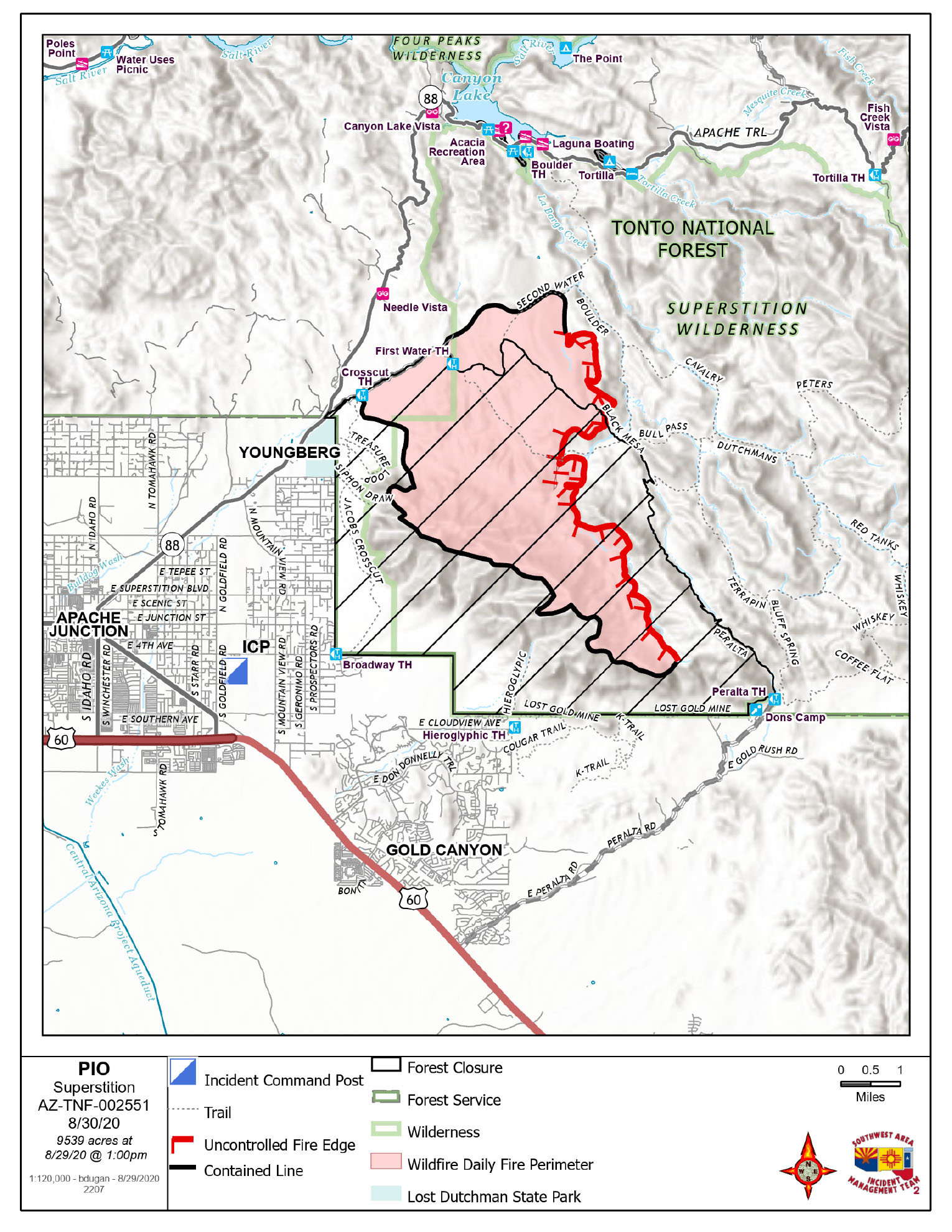
Superstition Fire Closure Order
Related Incident:
Publication Type: Closures
UNITED STATES DEPARTMENT OF AGRICULTURE FOREST SERVICE
TONTO NATIONAL FOREST MESA RANGER DISTRICT
Superstition Fire Public Safety Closure Order
PROHIBITIONS
Pursuant to 16 U.S.C. § 551 and 36 C.F.R. § 261.50(a), the following acts are prohibited within the area described in this Order (the “Restricted Area”) and as depicted on the attached map, hereby incorporated into this Order as Exhibit A, all within the Tonto National Forest, Pinal County, Arizona.
1. Going into or being upon the Restricted Area.36 C.F.R.§261.52(e).
EXEMPTIONS
Pursuant to 36 CFR § 261.50 (e), the following persons are exempt from this order:
1. Persons with a written Forest Service authorization specifically exempting them from the effect of this Order.
2. Any Federal, State, or local officer, or member of any organized rescue or firefighting resource in the performance of an official duty.
RESTRICTED AREA
All National Forest System lands contained within the following area.
Beginning at NFSR 78/SR 88 Junction, following NFSR 78 northeast to the First Water Trailhead, then following NFST 104 southeast approximately .25 miles to NFST 236, then following NFST 236 northeast to NFST 241, then following NFST 241 southeast to NFST 104, then following NFST southeast to NFST 104, then following NFST 104 southeast to NFST 102, then following NFST 102 southeast to Peralta Trailhead, then proceeding southwest from Peralta Trailhead to the Forest boundary, then following the Forest boundary west then north for approximately 12 miles to NFSR 78.
PURPOSE
The purpose of this Order is to close the Restricted Area during firefighting and emergency operations for the protection of public health and safety.
IMPLEMENTATION
This Order will be in effect at_0600 . on August 25, 2020 and shall remain in effect until September 30, 2020 or until rescinded, whichever occurs first.
A map identifying the Restricted Area is attached and made part of this Order as Exhibit A.
Any violation of this prohibition is punishable as a Class B misdemeanor by a fine of not more than $5,000 for individuals or $10,000 for organizations, or by imprisonment for not more than six (6) months, or both (see16 U.S.C.551, 18 U.S.C.3571(b)(6), 18 U.S.C.3581(b)(7)).
Further information regarding this Order may be obtained at the Tonto National Forest Supervisor’s Office in Phoenix, Arizona, (602)225-5200, or at Mesa Ranger District Office, (480)610-3300.
Dated this 26th day of August_ 2020, at Phoenix, Arizona
![]()
NEIL BOSWORTH
Digitally signed by NEIL BOSWORTH
Date: 2020.08.26 13:24:30 -07'00'
NEIL BOSWORTH
Forest Supervisor
Superstition final Hidden Fire Updates 8312020
Related Incident:
Publication Type: News
Superstition and Hidden Fire Update – August 31, 2020
Superstition Fire
Acres: 9,539
Percent Containment: 68%
Start Date: August 20, 2020
Injuries: 0
Cause: Lightning
Origin Location: Superstition Mountains, Tonto NF
Hidden Fire
Acres: 4605
Percent Containment: 2%
Start Date: August 25, 2020
Injuries: 0
Cause: Lightning
Origin Location: Sierra Ancha Mountains, Tonto NF
SUPERSTITION FIRE:
This is the final update for the Superstition Fire. The Southwest Area Incident Management Team 2 led by Incident Commander John Pierson thanks the local communities and cooperators for your support during suppression of Superstition Fire.
YESTERDAY:
Firefighters patrolled and monitored the perimeter. The Superstition Fire showed minimal growth yesterday. The area has received significant rainfall and grassy fuels that have previously enabled fire spread have mostly burned over.
TODAY’S ACTIVITY:
Minimal fire behavior is expected on the Superstition Fire today. Fire crews will continue to monitor the fire perimeter The Southwest Area Incident Management Team 2 has returned fire management to the local unit.
SUPERSTITION FIRE CLOSURES:
Hwy 88 closures have been lifted.
Canyon Lake and all surrounding recreation areas remain closed.
Lost Dutchman, all surrounding trailheads and trails remain closed.
Areas west of Peralta Canyon Road, areas north of Peralta Canyon Road, and the Peralta Trail.
Canyon Lake Recreational areas – please visit Tonto NF website for closure information: https://www.fs.usda.gov/detail/tonto/home/?cid=FSEPRD759501
View the closure order and map at: https://inciweb.nwcg.gov/incident/closures/7046/
HIDDEN FIRE YESTERDAY:
Hidden fire showed minimal growth yesterday due to increased humidity from scattered, light showers overnight. Successful burning operations along the southern perimeter produced most of the smoke that was observed yesterday. Helicopters made bucket drops along the northern edges of the fire and other areas of heat. Moderate fire behavior occurred upslope of Rock House Spring and in Skunk Creek Canyon.
TODAY’S ACTIVITY:
Minimum fire growth is expected today, and there is a high potential for wetting rains. Fire crews and dozers will be constructing direct and indirect line along the north, east and south perimeters. Firefighters will prepare for burning operations to be conducted along Road 1938 over the next few days. Structure and ranchland protection preparation will continue beyond the northeast edge of the fire.
AIR SUPPORT:
Due to the increased fire activity throughout the Southwest and California air support remains limited. We are using shared air resources of air tankers and helicopters with our neighboring Type 1 Incident Management Team.
HIDDEN FIRE CLOSURES:
Please visit Tonto NF website for closure information: https://www.fs.usda.gov/detail/tonto/home/?cid=FSEPRD759501
Facebook page: https://www.facebook.com/Hidden-Fire-Info-108681537629349
View the closure order and map here: https://inciweb.nwcg.gov/incident/article/7094/54530/
Wildfires are a No Drone Zone. The temporary flight restriction in place over the fire area please visit: https://tfr.faa.gov/save_pages/detail_0_8593.html for additional information. As a reminder, every time a drone is seen near the fire all aircraft are grounded until we can be sure the drone is clear of the area. For more information visit Know Before You Fly, http://knowbeforeyoufly.org.
Fire Information Phone Line: 520-261-5021
Fire Media Phone Line: 520-369-3757
Inciweb: https://inciweb.nwcg.gov/incident/7046/
Facebook: https://www.facebook.com/Superstition-Fire-Info-102207198283449
Smoke Outlook: wildlandfiresmoke.net/outlooks/easternarizona
Wildfire Smoke and COVID-19: https://www.cdc.gov/coronavirus/2019-ncoSuperstition and Hidden Fires Update August 30 2020
Related Incident:
Publication Type: News
Superstition Fire
Acres: 9539
Percent Containment: 58%
Start Date: August 20, 2020
Injuries: 0
Cause: Lightning
Origin Location: Superstition Mountains, Tonto NF
Hidden Fire
Acres: 4307
Percent Containment: 0%
Start Date: August 25, 2020
FireInjuries: 0
Origin Location: Sierra Poancha Mountains, Skunk Drainage
Cause: Lightning
Thunderstorms Douse Superstition Fire and Bring Moisture to Hidden Fire: Flash Flood Warnings
SUPERSTITION FIRE:
The HWY 88 corridor will be reopening at 0600 hour today, August 30, 2020 from Lost Dutchman State Park up to Fish Creek where the road was closed at the washout.
YESTERDAY: The Superstition Fire showed minimal growth yesterday and received heavy rain last night. Primary fire activity was in the northeast, within Superstition Wilderness.
TODAY’S ACTIVITY: Minimal fire behavior is expected on the Superstition Fire today. Fire crews will continue to patrol and monitor the fire perimeter. The Southwest Area Incident Management Team 2 will return the fire to the local unit today, Sunday, at 7:00 PM.
ROAD CLOSURES & RECREATION USE OF THE FOREST: This includes the closure of the following areas
AIR SUPPORT: Due to the increased fire activity through-out the Southwest and California air support remains limited. We are using shared air resources of air tankers and helicopters with our neighboring Type 1 Incident Management Team.
HIDDEN FIRE:
Southwest Area Incident Management Team 2 led by Incident Commander John Pierson assumed command of the Hidden Fire on Saturday morning, August 29, 2020 at 0600.
YESTERDAY: Hidden fire was active producing drifting smoke that settled in the Roosevelt Lake Valley overnight. The smoke should begin to clear and lift by mid-morning today. The fire showed moderate behavior on the northwest side within Skunk Tank Canyon as well as backing downslope towards Rock House Springs. Fire activity on the eastern fire perimeter was burning along Road 416 within the 2018 Bear Fire scar in open pine and grasses. A southerly fire growth through pine and pinyon/juniper showed moderate activity with occasional single tree torching and short-range spotting.
TODAY: Fire crews will conduct firing operations on the southern portion of the fire perimeter. Structure protection preparation on the northeast side of the fire perimeter will continue. The fire will continue to grow north, east and west. Fire line construction and fire line improvement will continue within the Tonto Basin.
AIR SUPPORT: Due to the increased fire activity through-out the Southwest and California air support remains limited. We are using shared air resources of air tankers and helicopters with our neighboring Type 1 Incident Management Team.
Gila County Sheriff’s Office placed residents in the communities of Brownsville and Jacks Corner in “SET” Status on 8/28/2020.
Wildfires are a No Drone Zone. The temporary flight restriction in place over the fire area please visit: https://tfr.faa.gov/save_pages/detail_0_8593.html for additional information. As a reminder, every time a drone is seen near the fire all aircraft are grounded until we can be sure the drone is clear of the area. For more information visit Know Before You Fly, http://knowbeforeyoufly.org.
Fire Information Phone Line: 520-261-5021
Fire Media Phone Line: 520-369-3757
InciWeb: https://inciweb.nwcg.gov/incident/7046/
Facebook: https://www.facebook.com/Superstition-Fire-Info-102207198283449
Smoke Outlook: wildlandfiresmoke.net/outlooks/EasternArizona