
Pronstico de Humo para 609 709
Related Incident:
Publication Type: News
Humo
La calidad del aire se verá afectada hoy en toda el área de
pronóstico. Esta mañana hay niveles de calidad de aire en
Insalubres o peor en el valle de Owens, el drenaje del río Kern
y el Parque Nacional Sequoia. Los vientos variables también
trasladarán humo del conjunto de fuegos SQF y el incendio
Creek hacia el Valle de San Joaquín y las colinas de la Sierra.
Más
Este pronóstico se basa en concentraciones de material
particulado solamente – No incluye ozono.
Sequoia Complex SQFComplex Update Sunday September 6
Related Incident:
Publication Type: News
Sequoia Complex (#SQFComplex) Fire Update
Sequoia and Inyo National Forests
September 6, 2020
Northern Rockies Incident Management Team 1
Mike Goicoechea, Incident Commander
Fire Information: 559-697-5148, 8AM-8PM
Email: sqfcomplex2020@gmail.com
Website: inciweb.nwcg.gov/incident/7048/
Facebook: www.facebook.com/SequoiaNF https://www.facebook.com/inyonf
Facebook: www.facebook.com/TulareCountyFireDepartment
Twitter: @sequoiaforest and @Inyo_NF
Incident Statistics
Location: 25 miles N of Kernville, CA
Date of origin: 8/19/20
Cause: Lightning
Size: 55,961 acres
Containment: 7%
Cost: $10 million
Injuries: 8
Civilians evacuated: 828
Structures threatened: 661
Resources
Hand Crews: 12
Engines: 45
Water-tenders: 21
Dozers: 8
Helicopters: 9
Personnel: 587
Sequoia (#SQF) Complex: The complex includes the Castle and Shotgun fires.
Castle Fire: Containment moved from 1% to 7% as firefighters mopped up along the southwest perimeter of the fire in the vicinity of Lloyd Flat. Yesterday afternoon, a large smoke column rose from the western side of the fire as it aggressively pushed to the west along Clicks Creek. Crews were able to burn off control lines and kept the fire from crossing those lines. Aircraft applied retardant in that area keeping the fire in check while supporting ground crews. Today, additional resources will be moved to the western side of the fire to assist in attacking the fire. The western edge of the fire is approximately 4-5 miles east of Sequoia Crest.
Crews continue to mop-up along the southwestern perimeter of the fire. Crews are constructing direct fireline and using old firelines on the northeast side of the fire in the Inyo National Forest to implement point protection to protect critical values at risk. Firefighters are building direct fireline where possible and using heavy equipment and chippers to build contingency lines on the southeastern side of the fire where the fire continues to move towards Little Horse and Osa Meadows. Structure assessment and protection continues for communities impacted by the fire, including Soda Flat, Jordan Hot Springs, and Casa Vieja Meadow, Cedar Slope, Ponderosa, Camp Nelson and Monache Meadows.
Acreage remains the same today, due to no infrared flight last night. The Castle Fire is mapped at 55,523 acres, including 11,022 acres within the Inyo National Forest boundary, and the remainder on the Sequoia National Forest.
Shotgun Fire: Estimated at 438 acres, the fire is slowly burning in a rocky drainage and is monitored by aircraft.
Weather: Sunday’s temperatures will be in the upper 80s at the higher elevations to 105 on the valley floor. Minimum relative humidity will be in the teens or single digits. Sunday’s winds will be from the south or southeast in the morning, from the west or southwest around noon and from the northwest in late afternoon.
Smoke: Air quality will be impaired throughout the Outlook area today. Unhealthy or worse levels are present this morning in Owens Valley, the Kern River drainage, and Sequoia National Park. Shifting winds will also bring smoke from the SQF Complex and the Creek Fire to the San Joaquin Valley and the Sierra foothills.
Evacuations and Closures:
Tulare County Sheriff issued an Evacuation Order on 9/4/20 for Alpine Village, Sequoia Crest and Redwood Drive. The Evacuation Order (8/28/20) is still in effect for: Ponderosa, Cedar Slope, Pyles Camp, and points between.
The Evacuation Warning is still in place for: Camp Nelson, Rodgers Camp, Coy Flat, Mountain Aire and Pier Point.
The Red Cross temporary evacuation center is located at Porterville College Stadium Gate 2.
Tulare County residents are encouraged to sign up for emergency notifications at alerttc.com
Roads are closed at Johnsondale Bridge and Sherman Pass, Hwy 190, and the County Transfer Station, as well as M107 and Mountain Road 50.
Campgrounds closed: Belknap, Coy Flat, Dome Rock, Lower Peppermint, Upper Peppermint, & Quaking Aspen
Sequoia National Forest issued Order No. 0513-20-31 SQF Complex Fire Area Road and Trails Closure on 8/26/2020.
Inyo National Forest issued Order No. 05-04-21-20-17 Inyo National Forest Castle Fire Trail, Road, and Area Closure on 9/3/20 which expands the closure area of the Golden Trout Wilderness and Monache Meadows. The original closure areas continue as specified in Order No. 05-04-51-20-16. These closures are for firefighter and public safety.
A Temporary Flight Restriction has been issued for the airspace around the fire complex. Drones are also prohibited.
Priorities include: Ponderosa, Cedar Slope, Alpine Village, Sequoia Crest, Redwood Drive, facilities within Trout Meadow, structures along the Lloyd Meadows Road, Pyles Boys Camp, grazing cattle west of North Road, Freeman Creek Grove and other Sequoia groves, the President George H.W. Bush Tree, Camp Whitsett, archeological values, Peppermint Fire Station, Mountain Yellow-Legged Frog and Little Kern Golden Trout Critical Habitats, Pacific Fisher habitats.
Smoke Outlook Sept 67 for Sequoia Complex SQFComplex
Related Incident:
Publication Type: News
Smoke
Air quality will be impaired throughout the Outlook area today.
Unhealthy or worse levels are present this morning in Owens
Valley, the Kern River drainage, and Sequoia National Park.
Shifting winds will also bring smoke from the SQF Complex and
the Creek fire to the San Joaquin Valley and the Sierra foothills.
Notes
Forecasts reflect particulate matter only – not ozone.
Sequoia Complex SQFComplex Update Saturday September 5
Related Incident:
Publication Type: News
Sequoia (#SQF) Complex Fire Update
Sequoia and Inyo National Forests
September 5, 2020
Northern Rockies Incident Management Team 1
Mike Goicoechea, Incident Commander
Incident Statistics
Location: 25 miles N of Kernville, CA
Date of origin: 8/19/20
Cause: Lightning
Size: 55,961 acres
Containment: 1%
Cost: $9.2 million
Injuries: 8
Civilians evacuated: 828
Structures threatened: 596
Resources
Hand Crews: 13
Engines: 51
Water-tenders: 16
Dozers: 10
Helicopters: 9
Personnel: 587
Fire Information: 559-697-5148, 8AM-8PM
Email: sqfcomplex2020@gmail.com
Website: inciweb.nwcg.gov/incident/7048/
Facebook: www.facebook.com/SequoiaNF
Facebook: www.facebook.com/TulareCountyFireDepartment
Twitter: @sequoiaforest
Sequoia (#SQF) Complex: The complex includes the Castle and Shotgun fires.
Castle Fire: The hot, dry weather with gusty afternoon winds is supporting fire growth on the eastern and western flanks. New spot fires developed yesterday west of Grey Meadow and Burnt Corral Meadows. With increased fire activity and forecasts for extreme fire weather, additional evacuation orders were issued for communities on the southwestern side of the fire. Dozers and hand crews continue to make substantial progress on containment lines, which now extend from White Meadow to the Forks of the Kern. Structure protection continues for nearby communities, including Soda Flat, Jordan Hot Springs, and Casa Vieja Meadow. Structure assessment has begun at Monache Meadows. The Castle Fire grew approximately 4,000 acres yesterday and is mapped at 55,523 acres, including 11,022 acres within the Inyo National Forest boundary, and the remainder on the Sequoia National Forest.
Shotgun Fire: Estimated at 438 acres, the fire is slowly burning in a rocky drainage, with continued aerial monitoring.
Weather: Extreme fire weather is forecast through the weekend, with increasing temperatures, low humidity, and potential for gusty afternoon winds. Light northwest winds are expected in the morning, shifting to the southwest and west in the late afternoon. The temperature is expected to reach 95 to 100 degrees today at 5,000 feet elevation.
Evacuations and Closures:
-
A Temporary Flight Restriction has been issued around the fire complex for aerial operations safety. Drones are prohibited. If you fly we can't.
-
Tulare County Sheriff issued an Evacuation Order on 9/4/20 for Alpine Village, Sequoia Crest and Redwood Drive. The Evacuation Order (8/28/20) is still in effect for: Ponderosa, Cedar Slope, Pyles Camp, and points between.
-
The Evacuation Warning is still in place for: Camp Nelson, Rodgers Camp, Coy Flat and Mountain Aire. Yesterday, Pier Point was added to the evacuation warning
Red Cross temporary evacuation center at Porterville College Stadium Gate 2.
-
Roads are closed at Johnsondale Bridge and Sherman Pass, Hwy 190, and the County Transfer Station, as well as M107 and Mountain Road 50.
-
Campgrounds closed: Belknap, Coy Flat, Dome Rock, Lower Peppermint, Upper Peppermint, & Quaking Aspen
-
Sequoia National Forest issued Order No. 0513-20-31 SQF Complex Fire Area Road and Trails Closure.
-
Inyo National Forest issued Order No. 05-04-21-20-17 Inyo National Forest Castle Fire Trail, Road, and Area Closure on 9/3/20 which expands the closure area of the Golden Trout Wilderness and Monache Meadows. The original closure areas continue as specified in Order No. 05-04-51-20-16. These closures are for firefighter and public safety.
Smoke Impact: Impacts from smoke will start this morning along the Sierra front and areas west of the fire, then shift in the afternoon to Kennedy Meadows, Owens Valley, and areas southeast of the fire including Ridgecrest. Kernville and Lake Isabella will see some relief in the morning before degrading to Unhealthy in the afternoon
Priorities include: Ponderosa, Cedar Slope, Forks of the Kern Trailhead; Jerkey Meadows Trailhead; facilities and trails within Trout Meadow; structures and facilities along the Lloyd Meadows Road; Pyles Boys Camp; grazing cattle west of North Road; Freeman Creek Grove and other Sequoia tree groves; the President George H.W. Bush Tree; Camp Whitsett, featuring numerous Native American archeological values; Peppermint Fire Station; the Mountain Yellow-Legged Frog and Little Kern Golden Trout Critical Habitats; Pacific Fisher habitats.
Special notes: Fire managers will employ tactics that safely engage fire while prioritizing firefighter and public safety and protecting values at risk. Life safety will always remain the number one priority. COVID-19 mitigations are being taken to limit exposure risks to firefighters and the public, per CDC guidelines.
Smoke Outlook for 95 96
Related Incident:
Publication Type: News
Fire
The SQF Complex is 55,961 acres in size, an increase in 3,944 acres. Similar active fire behavior is expected again today in grass, brush, and timber fuels. Line building continues on the southwest perimeter between Summit Trailhead and Jerkey Meadows. For more information visitinciweb.nwcg.gov/incident/7048.
Smoke
Air quality impacts will start this morning along the Sierra front and areas west of the fire, then shift in the afternoon to Kennedy Meadows, Owens Valley and areas southeast of the fire including Ridgecrest. Kernville and Lake Isabella will see some relief in the morning before degrading to Unhealthy in the afternoon.
Notes
Forecasts reflect particulate matter only – not ozone.
Printable versions of the smoke report in English and Spanish may be found below.
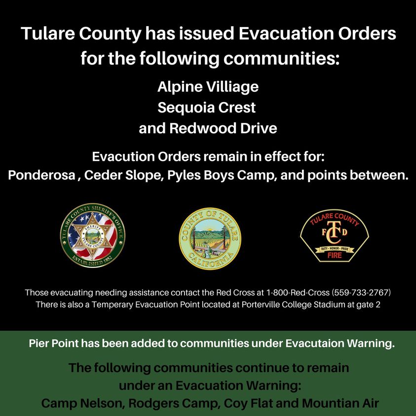
Tulare County has Issued Additional Evacuation Orders
Related Incident:
Publication Type: Announcement
Tulare County has issued evacuation orders for the following communities:
Alpine Village
Sequoia Crest
and Redwood Drive
Evacuation orders remain in effect for:
Ponderosa
Cedar Slope
Pyles Boys Camp
and points in between
Evacuation warnings remain in effect for:
Camp Nelson
Rodger Camp
Coy Flat
Mountain Air
The full image is at Related Information below:
Smoke Outlook for 94 95
Related Incident:
Publication Type: News
Smoke Outlook for 9/04 - 9/05
Southern Sierra - Sequoia : SQF Complex
Issued at: 2020-09-04 07:20 PDT
Fire - The SQF Complex is 52,189 acres in size, an increase in 5,861acres. Active fire behavior is occurring in grass, brush, and timber fuels over complex wilderness terrain. For more information visit inciweb.nwcg.gov/incident/7048.
Smoke - The overnight inversion along the Kern River will continue to collect unhealthy concentrations of particulate matter. Smoke will also impact areas to the north, west and south, from Pinehurst to Tehachapi with Moderate to Unhealthy for Sensitive Groups (USG). Kernville, Johnsondale, Kennedy Meadows, and Lake Isabella will be Unhealthy to Very Unhealthy with periods of improvement late in the day. The Owens Valley will be Good to Moderate.
Notes - Forecasts reflect particulate matter only – not ozone. A monitor at Mineral King in Sequoia National Park has been added to the outlook.
The complete smoke outlooks in both English and Spanish may be found under Related Information below.
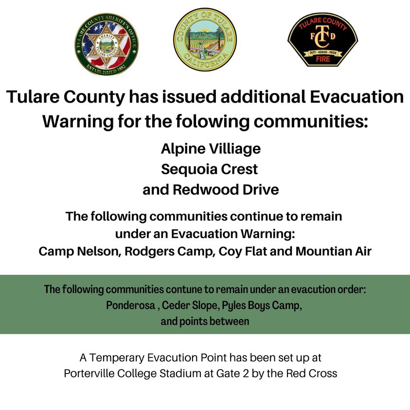
Tulare County has issued additional Evacuation Warning
Related Incident:
Publication Type: Announcement
Tulare County has issued additional Evacuation Warning for the following communities:
Alpine Village
Sequoia Crest
and Redwood Drive
The following communities continue to remain under an Evacuation Warning: Camp Nelson, Rodgers Camp, Coy Flat and Mountain Air
The following communities continue to remain under an Evacuation Order: Ponderosa, Cedar Slope, Pyles Boys Camp and points in between.
A temporary evacuation point has been set up at Porterville College Stadium at Gate 2 by the Red Cross.
September 4 Fire Update
Related Incident:
Publication Type: News
SQF Complex Fire Update
Sequoia and Inyo National Forests
September 4, 2020 Northern Rockies Incident Management Team 1
Mike Goicoechea, Incident Commander
Incident Statistics Location: 25 miles N of Kernville, CA
Date of origin: August 19, 2020
Size: 52,017 acres
Containment: 1% Cause: Lightning
Injuries: 6
Cost: $8.2 million
Resources:
- Hand Crews: 11
- Engines: 43
- Water-tenders: 16
- Dozers: 8
- Helicopters: 9
- Personnel: 630
Email: sqfcomplex2020@gmail.com
Website: inciweb.nwcg.gov/incident/7048
Facebook: www.facebook.com/SequoiaNF
Facebook: www.facebook.com/TulareCountyFireDepartment
Twitter: @sequoiaforest
SQF Complex: The SQF Complex, encompassing the Castle and Shotgun fires, has burned 52,017 acres. Approximately 11,000 acres of the Castle Fire is located within the Inyo National Forest boundary, with the remainder on the Sequoia National Forest. The containment remains at 1%.
Evacuations and Closures:
Tulare County Sheriff’s Evacuation Order (August 28, 2020) is active for: Cedar Slope, Ponderosa, and Pyles Camp. · The Evacuation Advisory is still in place for: Camp Nelson, Rodgers Camp, Coy Flat and Mountain Aire. Red Cross temporary evacuation center at Porterville College Stadium Gate 2. · Roads are closed at Johnsondale Bridge and Sherman Pass, Hwy 190, and the County Transfer Station, as well as M107 and Mountain Road 50. Campgrounds closed: Dome Rock, Lower Peppermint, Upper Peppermint, & Quaking Aspen Sequoia National Forest issued Order No. 0513-20-31 SQF Complex Fire Area Road and Trails Closure. Inyo National Forest issued Order No. 05-04-21-20-17 Inyo National Forest Castle Fire Trail, Road, and Area Closure on September 3, 2020 which expands the closure area of the Golden Trout Wilderness and Monache Meadows. The original closure areas continue as specified in Order No. 05-04-51-20-16. These closures are for firefighter and public safety.
Inyo National Forest Closure Order Revised for SQF Complex Fire
Related Incident:
Publication Type: Closures
Forest Closure Order Revised for SQF Complex Fire
Includes Monache Meadows
USDA Forest Service
Inyo National Forest
351 Pacu Lane, Suite 200
Bishop, CA 93514
Media Contact: Deb Schweizer (760) 873-2427
debra.schweizer@usda.gov
www.facebook.com/inyonf
Twitter: @Inyo_NF
September 3, 2020
The Inyo National Forest has revised the forest closure order due to the SQF Complex (Castle Fire and Shotgun Fire) for firefighter and public safety. This encompasses additional areas of the Golden Trout Wilderness and now includes Monache Meadows (outside of the wilderness). Monache Meadows is a popular Off Highway Vehicle (OHV) destination.
In addition, the Sequoia National Forest has closures for the SQF Complex under their administration.
The Inyo’s closure follows trail networks from Siberian Pass at the northern boundary with Sequoia National Park, remains west of Big Whitney Meadow, Ramshaw Meadow, Hessian Meadow, and Cow Canyon at the southern boundary with Sequoia National Forest. Please see the map for better detail.
For now, the north eastern part of the Golden Trout Wilderness on the Inyo remains open, which keeps the Pacific Crest Trail and trails at Cottonwood Pass, Trail Pass, and Cottonwood Lakes open as long as those itineraries avoid the closure areas on the Inyo and the Sequoia National Forest (as a rule itineraries heading north from these trails).
If you are considering hiking or backpacking into the South Sierra Wilderness, the Golden Trout Wilderness, or southern parts of the John Muir Wilderness from the Inyo National Forest, understand that there is uncontained wildfire and substantial smoke in the area. Other alternatives are highly advised.
The SQF Complex Fire started by lightning and is currently 46,328 acres and 1% contained.
-###-
USDA is an equal opportunity provider, employer, and lender.