
SQF Complex Holds Press Conference to Welcome Mexico Crews
Related Incident:
Publication Type: Announcement
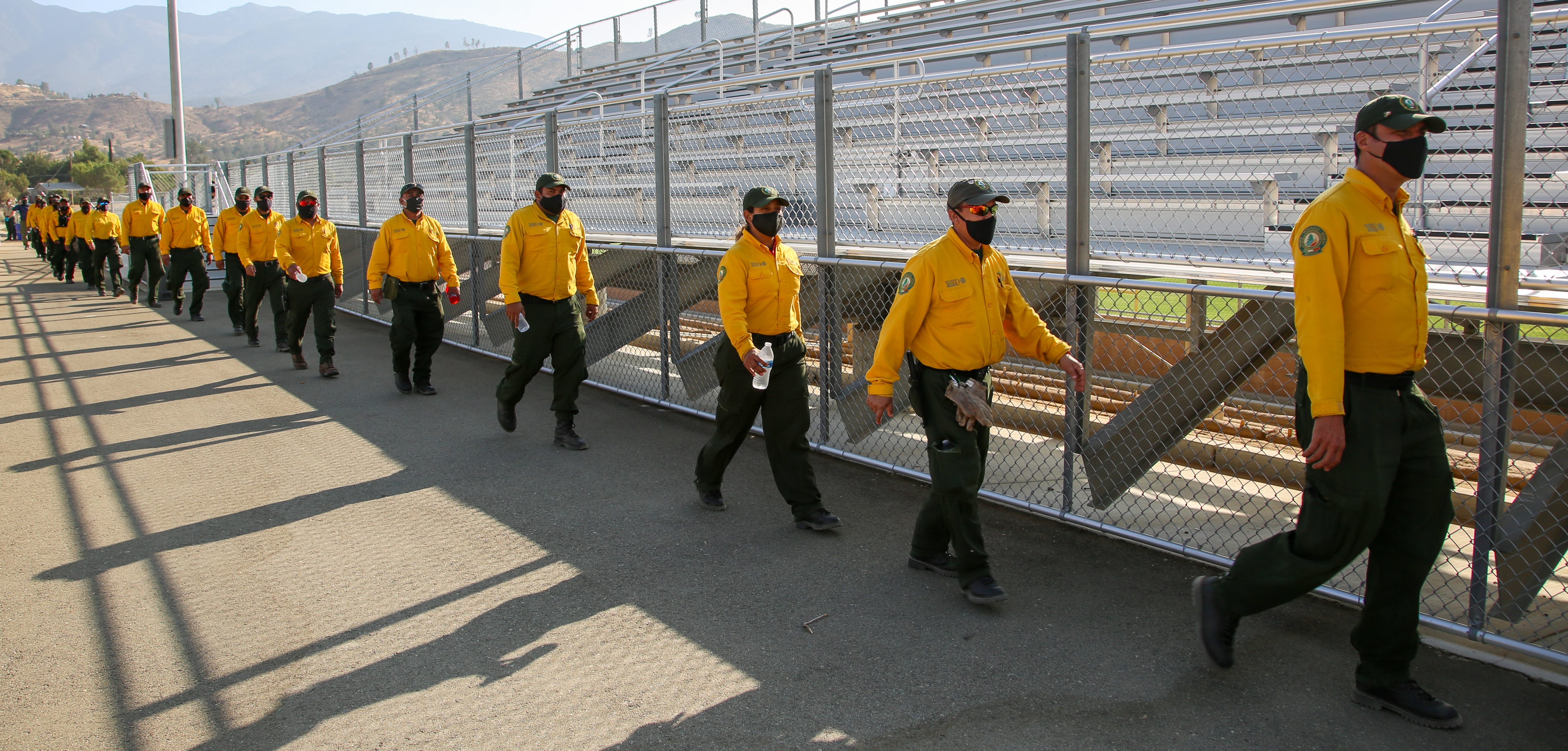
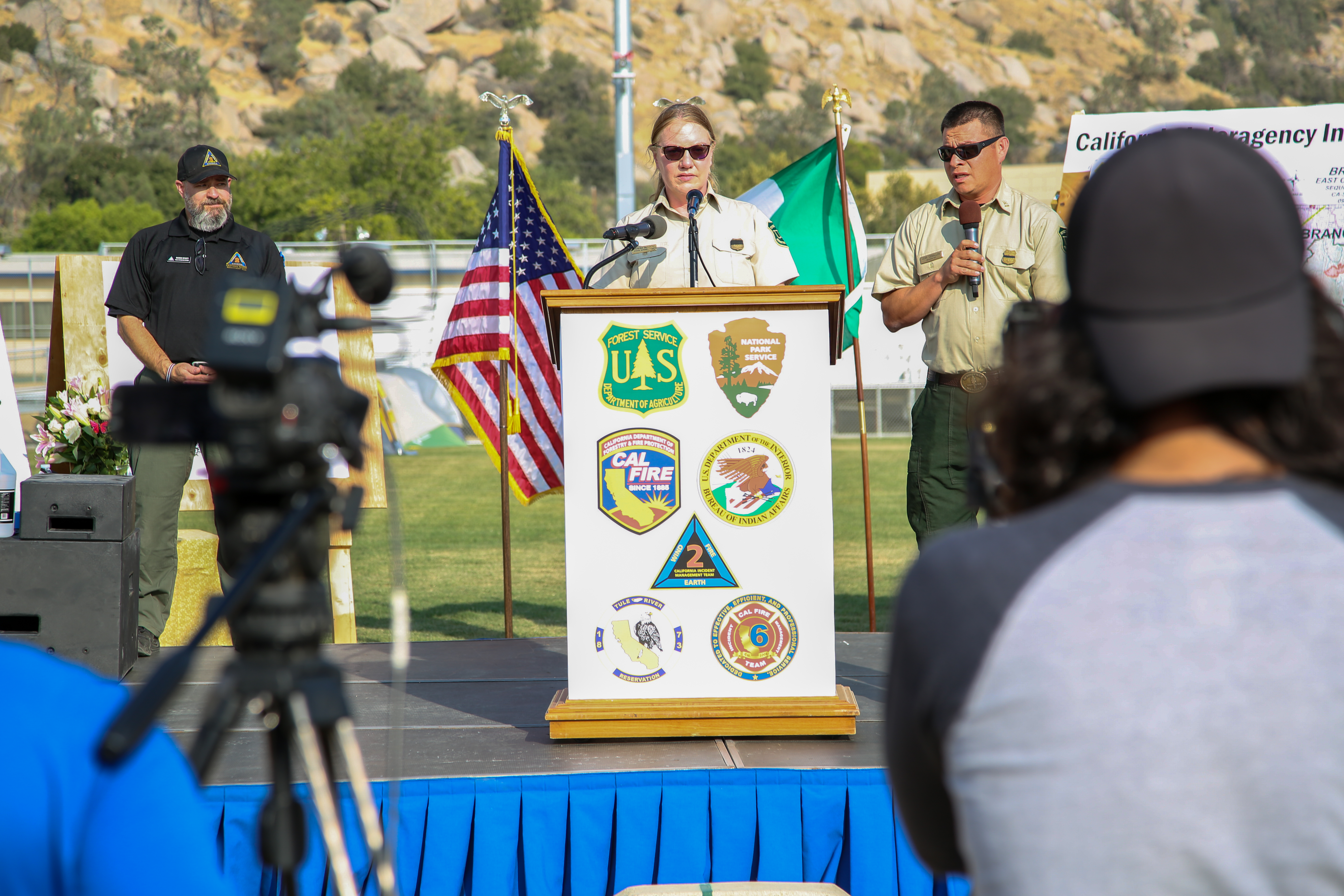
LAKE ISABELLA, CA- Photos from Friday's press event at Kern Valley High School in Lake Isabella, CA to welcome the fire crews from Mexico to the Sequoia Complex on the Sequoia National Forest. The firefighters received a warm welcome from Theresa Benson the Forest Supervisor of Sequoia National Forest. Jeff Veik, Incident Commander of Cal Fire Team 6, explained the challenges of California's wildfire situation and extended hot dry weather conditions during this historic fire season. Mike Minton, Incident Commander of California Interagency IMT 2, described the diverse landscape in this area from the oak savannah to some of the largest trees in the world. He explained even though fire is beneficial to sequoias, too much intensity may harm the trees. Eduardo Cruz, National Fire Management Director for CONAFOR thanked everyone who has helped make this international partnership possible. Ramon Silva Flores, Deputy Chief of Conservation and Restoration for CONAFOR, stated he is happy to offer up their experience to work and provide support to the United States during this unprecedented wildfire season. Officials who spoke at the event:Teresa Benson, Forest Supervisor, Sequoia National ForestMike Minton, Incident Commander, California Interagency Incident Management Team 2Jeff Veik, Incident Commander, CalFIre Incident Management Team 6Ramon Silva Flores, Deputy Chief of Conservation and Restoration for Comisión Nacional ForestalEduardo Cruz, National Fire Management Director for Comisión Nacional ForestalInterviews with Mexican firefighters
Sequoia Complex Public Information Meeting at 4pm Sunday Sept 27
Related Incident:
Publication Type: Announcement
The Sequoia Complex (#SQFComplex) will host a public information meeting at 4 p.m. on Sunday, September 27, 2020. The meeting will be broadcast via Facebook Live and will also be available for viewing at later times. Questions may be submitted in advance to sqfcomplex2020@gmail.com.
The live stream will appear at the top of the Sequoia National Forest Facebook page a few minutes before 4:00 p.m. www.facebook.com/SequoiaNF
Sequoia Complex Update SQFComplex for Sept 27
Related Incident:
Publication Type: News
Current Situation:
Firefighters had another productive day on the Sequoia Complex East Zone yesterday. Containment of the complex has increased to 47%. Changing weather will be a factor in the fight today. An east wind will bring lower relative humidity and temperatures are forecast to be five to seven degrees above normal. This will test containment lines that have been constructed over the last several days. Previously, most of the fire movement occurred as winds carried embers outside the lines causing spot fires.
Today, fire crews will focus on constructing and improving fireline between Coy Flat and the Kern River drainage. East winds will have the highest impact on this portion of the East Zone perimeter. Several Hotshot crews and CONAFOR hand crews from Mexico have been working this area. There are still many hazard trees along the line and crews will be working to fall any tree that poses a threat to containment. Firefighters will also be continuing the work to protect structures in Ponderosa, Cedar Slope, Alpine Village, Jordan Peak, Sequoia Crest and several communities within the fire area.
On the north side of the fire, in the area of Pecks Cabin, firefighters are scouting the area to develop a plan to address the uncontained fireline. As work is completed in higher priority areas of the fire, crews will shift up to address this uncontained line.
The process of backhaul, breaking down and removing equipment and supplies no longer needed in the fire area, has been initiated on the east portion of the fire and around several communities.
A community meeting will be held at 4 PM on Sunday, September 27, for both zones of the Sequoia Complex. The meeting will be held via Facebook Live on the Sequoia National Forest’s Facebook page. Questions may be submitted in advance to the East Zone (sqfcomplex2020@gmail.com) and to the West Zone (westcastlezone@gmail.com).
Weather: A warming and drying trend will impact the area for the next several days. Temperatures will be five to seven degrees above normal and relative humidity will dip into the low teens and potentially, single digits.
Evacuations:
- Evacuation Orders, Map and Warnings for Tulare County.
- Areas Downgraded to an Evacuation Warning:
- All of South Fork Drive below Cinnamon Canyon Road
- Including Cinnamon Canyon Road
- All remaining Evacuation Orders and Evacuation Warnings remain in place
- Tulare County has a structure assessment form for evacuees affected by the fire to provide contact information for County officials as the damage assessment continues.
- An interactive map showing damaged structures is available.
- Tulare County Health & Human Services Agency hotline for affected citizens – (559) 802-9790
- The Red Cross has evacuation centers at Porterville Community College and the North Exeter Community Building. Also, call the Red Cross at 1-800-RED-CROSS or https://tinyurl.com/yafetgkj
Closures:
- Sequoia and Inyo National Forests closure is extended: Regional Order No. 20-17
- Regional Emergency Fire Restrictions are in place: Regional Order No. 20-16
- The Bureau of Land Management Bakersfield Office has issued a temporary emergency closure.
- Road closures due to the SQF Complex may be found by clicking here.
- The Temporary Flight Restriction (9/19/20) may be found here. Drones over the fire area are prohibited.
- Sequoia National Park remains closed due to fire threat, including Generals Highway from Ash Mountain Entrance in Three Rivers to the Woodward Gate west
Smoke: Current air quality may be found at https://fire.airnow.gov/.
Alert: To receive emergency notifications regarding evacuations and critical events sign up at alerttc.com.
Cooperating and Assisting Organizations: Tulare County Fire Department, Tulare County Sheriff’s Department, California Highway Patrol, Tule River Tribe, California Rehabilitation Center Fire Department, California Conservation Corps, California Office of Emergency Services, and Bureau of Land Management.
Safety Message: This will be a long duration event. Residents in the affected areas are encouraged to continue to prepare for the possibility of fire in their area in advance. Go to https://www.ready.gov/wildfires to learn how to prepare.
SQF Smoke Outlook for 927
Related Incident:
Publication Type: News
Smoke
Air quality across the outlook area is expected to remain
unhealthy with lingering smoke and increasing wind pattern
shifts to the west, south-west. Active fires continue within the
fire perimeter contributing to smoke conditions.
Special Notes
Higher temperatures will remain above average and continue
throughout the week. Air quality alerts have been issued for
areas within this outlook. For more information reference the
links below.
SEQUOIA FIRE UPDATE Sheriff Downgrades More Evacuation Orders to Warnings
Related Incident:
Publication Type: Announcement
SEQUOIA FIRE UPDATE: Sheriff Downgrades More Evacuation Orders to Warnings
Sheriff Boudreaux has downgraded parts of South Fork Drive and Cinnamon Canyon Road from a Mandatory Evacuation Order to a Voluntary Evacuation Warning.
Areas Downgraded to an Evacuation Warning:-All of South Fork Drive below Cinnamon Canyon Road-Including Cinnamon Canyon Road
All remaining Evacuation Orders and Evacuation Warnings remain in place
An Voluntary Evacuation Warning means people living in the area are able to return to their homes, but should still be ready to evacuate should fire conditions change. These areas will continue to have check points and residents with proof of residency will be allowed to enter the area.
SQF Complex Update for 926
Related Incident:
Publication Type: News
Current Situation:
Yesterday, smoke and slightly higher RH moderated fire behavior and reduced fire intensity. Spotting is still occurring and there is short range, minimal forward fire progression. Some interior pockets burned but with no threat to the line. Overall most of the fire was smoldering and creeping.
With fire activity low, crews made significant progress in several areas. In the northeastern area, near the Kern River Station, the spike crew accomplished their mission. In the southeastern area, including Little Horse Meadows, a significant amount of control line has been created. Crews will continue creating defensible space in the area. In the south, near Kern River, crews are building dozer line and tree fellers are working to bring down snags to eliminate sources of falling embers causing spot fires. Hotshot crews are working in the Camp Nelson area of the fire creating direct and indirect line.
Today, spotting will be the primary source of fire spread. All fuels are available to burn and will be receptive to spotting. Expect single tree torching in the denser stands of timber. There are large pockets of bug kill in the
fire’s path and the trees that still have needles will be a significant source for torching and spotting. Crews will continue building direct and indirect lines, and will monitor and mitigate spot fires, as well as create defensible space around structures. Crews will also implement defensive firing operations in the Ponderosa area.
Weather: Little change in overall weather conditions Saturday with a continuation of high pressure inversion. Expect poor visibility in addition to cooler temperatures during the day due to smoke shading the sun. Ridge winds south to southwest. Areas above 8000 feet will be above the cloud layer allowing some aviation work in these areas.
Evacuations:
· Evacuation Orders, Map and Warnings for Tulare County. Evacuation Orders for some areas have been downgraded to Evacuation Warnings, and the Evacuation Warning for Springville has been removed.
· Tulare County has a structure assessment form for evacuees affected by the fire to provide contact information for County officials as the damage assessment continues.
An interactive map showing damaged structures is available.
Tulare County Health & Human Services Agency hotline for affected citizens – (559) 802-9790
The Red Cross has evacuation centers at Porterville Community College and the North Exeter Community Building. Also, call the Red Cross at 1-800-RED-CROSS or https://tinyurl.com/yafetgkj
Closures:
Sequoia and Inyo National Forests closure is extended: Regional Order No. 20-17
Regional Emergency Fire Restrictions are in place: Regional Order No. 20-16
The Bureau of Land Management Bakersfield Office has issued a temporary emergency closure.
Road closures due to the SQF Complex may be found by clicking here.
The Temporary Flight Restriction (9/19/20) may be found here. Drones over the fire area are prohibited.
Sequoia National Park remains closed due to fire threat, including Generals Highway from Ash Mountain Entrance in Three Rivers to the Woodward Gate west
Smoke: Current air quality may be found at https://fire.airnow.gov/.
Alert: To receive emergency notifications regarding evacuations and critical events sign up at alerttc.com.
Cooperating and Assisting Organizations: Tulare County Fire Department, Tulare County Sheriff’s Department, California Highway Patrol, Tule River Tribe, California Rehabilitation Center Fire Department, California Conservation Corps, California Office of Emergency Services, and Bureau of Land Management.
Safety Message: This will be a long duration event. Residents in the affected areas are encouraged to continue to prepare for the possibility of fire in their area in advance. Go to https://www.ready.gov/wildfires to learn how to prepare.
SQF Complex Smoke Outlook for 926
Related Incident:
Publication Type: News
Smoke
Air quality across the outlook area is expected to remain unhealthy with lingering smoke and increasing wind pattern shifts to the west, south-west. Active fires continue within the fire perimeter contributing to smoke conditions.Special Notes
Extreme temperatures are expected beginning Sunday and throughout the week. Air quality alerts have been issued for more information reference the link below.Sequioa Complex Update SQFComplex for Sept 25
Related Incident:
Publication Type: News
Incident Information:
Start / Report Date: 8/19/20
Cause: Lightning
Size: 144,777 acres
Location: 25 miles N of Kernville, CA
Containment: 36 %
Injuries: 15
Structures Destroyed: 214
Resources:
Hand Crews: 27
Dozers: 53
Helicopters: 9
Water Tenders: 37
Engines: 110
Total Personnel: 1,763
Fire History: The SQF Complex is a combination of two fires, the Castle Fire and the Shotgun Fire. The Shotgun Fire started on August 18, 2020, and the Castle Fire on August 19, 2020. Both fires were determined to have been caused by lightning strikes. On August 24, 2020, the fires were combined as the Sequoia Complex (SQF Complex). Due to the complexity of the incident, a Type 2 Incident Management Team was ordered, and California Interagency Incident Management Team 12 took command of the incident. On September 3, 2020, command of the incident was transferred to the Northern Rockies Incident Management Team 1, a Type 1 team. On September 16, 2020, the complex was divided into two zones; East and West. CAL FIRE Incident Management Team 6 assumed command of the West Zone and the Northern Rockies IMT maintained command of the East zone. On September 23, 2020, California Interagency Incident Management Team 2 took command of the East zone. The Sequoia Complex is currently under Unified Command between the United States Forest Service, National Park Service, CAL FIRE, California Interagency Incident Management Team 2, and CAL FIRE Team 6.
Fuels:
Fuel models located within the fire area vary with elevation and some have limited fire history. These include stands of dense mixed conifer with heavy brush below timber lines. The McNally burn scar (2002), Pier burn scar (2017), and Schaefer burn scar (2017) contain a mixture of grass, brush and snags which are all supporting fire spread. Fire is burning within areas of significant tree mortality, with snags causing spotting, contributing to significant fire resistance to control efforts.
Current Situation:
Yesterday, smoke and slightly higher RH levels moderated fire behavior, reducing fire intensity. Spotting is still occurring but with minimal short-range forward fire progression. Some interior pockets burned but with no threat to the line. Overall, most of the fire was smoldering and creeping.
Today, fire activity will be much the same as yesterday. Fire movement is expected on the southern end of the fire from Camp Nelson to the Kern River. Residual heat from the initial fire front continues to impact the communities of Cedar Slope, Alpine Village, Jordan Peak, and Sequoia Crest. Threats to structures/infrastructure include Peppermint Work Center, Camp Nelson, Pierpoint, Ponderosa, Rogers Camp, Mountain Aire, and the Tule Indian Reservation. There continues to be strong potential for spotting across the Kern River, compromising
established control lines on the east side of Kern Canyon. Overall fire growth is predicted to be the similar as the last 12 hours. Crews will patrol and mop up along containment lines, will be falling trees west of the Kern River to prevent rollout and possible escape across the lines, and will strengthen control and containment lines where feasible.
Weather: Little change in overall weather conditions Friday with a continuation of stable conditions leading to light winds and heavy smoke. Highs will remain in the 70s to lower 80s and RHs can expect to drop into the mid-20s to mid-30s. Upper level winds will continue to be northwest helping to push the smoke southeast. Concerns through Saturday will be focused around poor visibility due to the higher smoke concentrations.
Evacuations:
- • Evacuation Orders, Map and Warnings for Tulare County. Evacuation Orders for some areas have been downgraded to Evacuation Warnings, and the Evacuation Warning for Springville has been removed.
- • Tulare County has a structure assessment form for evacuees affected by the fire to provide contact information for County officials as the damage assessment process continues.
- • An interactive map showing damaged structures is now available.
- • Tulare County Health & Human Services Agency hotline for affected citizens – (559) 802-9790
- • The Red Cross has evacuation centers at Porterville Community College and the North Exeter Community Building. Also, call the Red Cross at 1-800-RED-CROSS or https://tinyurl.com/yafetgkj
Closures:
- • Sequoia and Inyo National Forests closure has been extended: Regional Order No. 20-17
- • Regional Emergency Fire Restrictions are in place: Regional Order No. 20-16
- • The Bureau of Land Management Bakersfield Office has issued a temporary emergency closure.
- • Road closures due to the SQF Complex may be found by clicking here.
- • The Temporary Flight Restriction (9/19/20) may be found here. Drones over the fire area are prohibited.
- • Sequoia National Park remains closed due to fire threat, including Generals Highway from Ash Mountain Entrance in Three Rivers to the Woodward Gate west
Smoke: Current air quality may be found at https://fire.airnow.gov/.
Alert: To receive emergency notifications regarding evacuations and critical events sign up at alerttc.com.
Cooperating and Assisting Organizations: Tulare County Fire Department, Tulare County Sheriff’s Department, California Highway Patrol, Tule River Tribe, California Rehabilitation Center Fire Department, California Conservation Corps, California Office of Emergency Services, and Bureau of Land Management.
Safety Message: This will be a long duration event. Residents in the affected areas are encouraged to continue to prepare for the possibility of fire in their area in advance. Go to https://www.ready.gov/wildfires to learn how to prepare.
Forest Service Extends Closure Orders and Fire Restrictions in California
Related Incident:
Publication Type: Closures
Forest Service Extends Closure Orders and Fire Restrictions in California
VALLEJO, Calif. – The USDA Forest Service Pacific Southwest Region announces that current closure orders and fire prohibitions in California have been extended. This decision will be evaluated daily, taking fire and weather conditions into account. The fire prohibition includes building, maintaining, attending, or using a fire, campfire, or stove.
Nine National Forests (NF) in California remain closed: Angeles NF, Cleveland NF, Los Padres NF, Inyo NF, Klamath NF, San Bernardino NF, Sequoia NF, Sierra NF, and Six Rivers NF. This decision will continue to be reviewed daily.
Nine other National Forests may be open to varying degrees. Visitors should contact the following National Forests for more information on their status: Eldorado NF, Lake Tahoe Basin Management Unit, Lassen NF, Mendocino NF, Modoc NF, Plumas NF, Shasta-Trinity NF, Stanislaus NF, and the Tahoe NF. For additional questions, please contact your local National Forest.
"Continued closures are based on extreme fire conditions, critical limitations of firefighting resources, and to provide for firefighter and public safety,” said Randy Moore, Regional Forester for the USDA Forest Service Pacific Southwest Region. "We understand how important access to the National Forests is to our visitors. Our aim is to prevent any new fires on the landscape."
If you do intend to visit a National Forest that is open to visitors, we continue to recommend that you not travel long distances to recreate. If you or anyone in your household is feeling sick, please remain at home and plan your trip for another time. All visitors should practice self-sufficiency during your visits to national forests. Recreating responsibly will help ensure that expanded access to recreational facilities, services, and opportunities continues. Responsible recreation practices should be maintained at all times, including:
• Maintaining at least six feet distancing from others
• Do not gather in groups and please follow the latest guidance from officials
• Communicate with others as you pass. Alert trail users of your presence and step aside to let others pass
• Pack out your trash and leave with everything you bring in and use.
• All services may not be available, so please plan accordingly.
The Forest Service manages 18 National Forests in the Pacific Southwest Region, which encompasses over 20 million acres across California, and assists State and Private forest landowners in California, Hawaii and the U.S. Affiliated Pacific Islands. National forests supply 50 percent of the water in California and form the watershed of most major aqueducts and more than 2,400 reservoirs throughout the state. For more information, visit www.fs.usda.gov/R5.
Smoke Outlook for Sequoia Complex Friday Sept 25
Related Incident:
Publication Type: News
Smoke
Air quality across the outlook area is expected to remain
unhealthy resulting in lingering smoke west of the fire during
the day. Regional smoke mixing within this outlook area may
contribute to unhealthy conditions to the east.
Special Notes
A shift in weekend wind patterns will result in heavier,
lingering smoke to the west. Air quality alerts have been
issued for more information reference the link below.