
Tulare County Downgrades PORTION of Evacuation Area
Related Incident:
Publication Type: Announcement
Sheriff Boudreaux has downgraded some areas that were under Evacuation Orders to Evacuation Warnings, and has removed the Evacuation Warning for Springville.
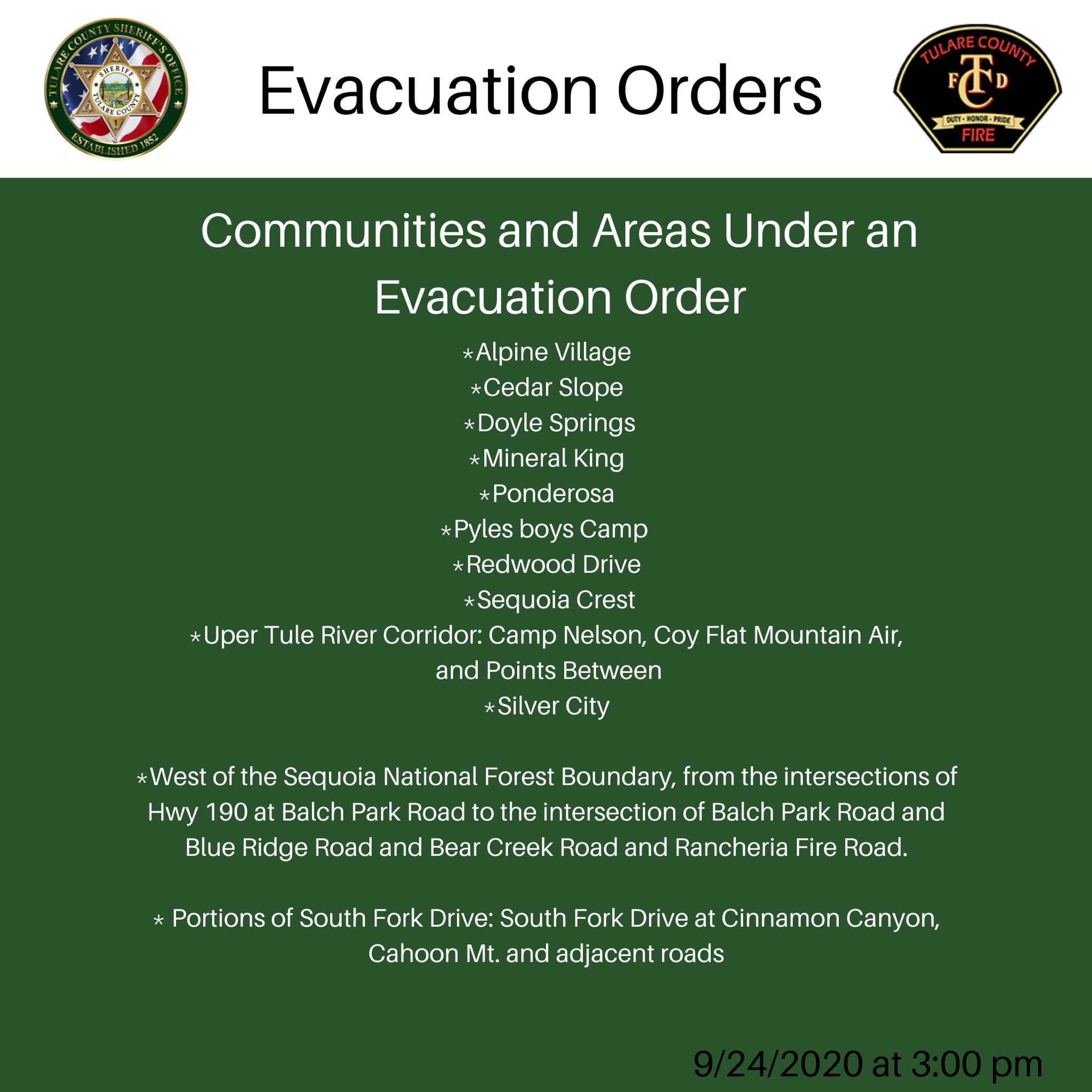
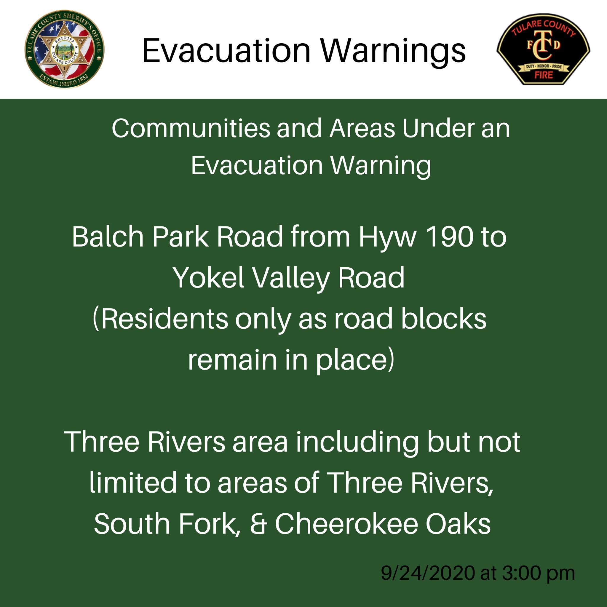
Areas DOWNGRADED to Evacuation Warnings:
-Balch Park Road from Hwy 190 to Yokel Valley Road
-Balch Park Road below Blue Ridge Road
-Bear Creek Road below SCICON
Areas REMOVED from the Evacuation Warning list:
-Springville, all points between Globe Drive and Balch Park Road
An Evacuation Warning means people living in the area are able to return to their homes, but should still be ready to evacuate should fire conditions change. These areas will continue to have check points and only residents with proof of residency will be allowed to enter the area.
All remaining Evacuation Orders and Evacuation Warnings remain in place.
Smoke Outlook for Sequoia Complex SQFComplex Thursday Sept 24
Related Incident:
Publication Type: News
Smoke
Air quality across the outlook area is expected to remain
unhealthy resulting in lingering smoke west of the fire during
the day. Regional smoke mixing within this outlook area may
contribute to unhealthy conditions to the east.
Special Notes
A shift in weekend wind patterns will result in heavier,
lingering smoke to the west. Air quality alerts have been
issued for more information reference the link below.
Sequoia Complex SQF Complex Update Thusday September 24
Related Incident:
Publication Type: News
East Castle Zone Sequoia Complex
September 24, 2020 UPDATE
Start / Report Date: 8/19/20
Cause: Lightning
Size: 144,826 acres
Location: 25 miles N of Kernville, CA
Containment: 35%
Injuries: 15
Structures Destroyed: 189
Resources:
Hand Crews: 25
Dozers: 35
Helicopters: 9
Water Tenders: 35
Engines: 103
Total Personnel: 1,508
Current Situation: Yesterday, a significant smoke layer moderated fire behavior allowing a small advance in containment, but the smoke also hampered aircraft use.
In the northeast, structure protection is ongoing at the Kern Canyon Ranger Station with a crew spiked out. Crews are working to secure fire line from Lion Meadows north to Little Horse Meadows, with significant progress made. Fire activity continued on the southern end of the fire from Camp Nelson to the Kern River. As the daytime temperatures increased, fire continued to move toward the indirect line near Needles ridge. Lines are being tested by this increase in activity. The structure protection measures around the community of Ponderosa are nearly complete. Spotting is still a concern. West of Ponderosa, the fire continues to push the dozer lines. While these lines have held, anticipated changes in wind direction could challenge existing control lines. All others edges of the East Zone saw minimal growth.
Crews are focused on point protection for structures that are immediately threatened. Resources will continue to monitor and hold completed control lines, as well as point protection to back country structures. Crews will watch for, and quickly attack, any spot fires on the east side of the Kern River Canyon. Resource shortages due to heavy fire activity in the western US are limiting containment efforts and protecting values at risk remains the highest priority. Crews are monitoring the communities of Sequoia Crest, Alpine, and Cedar Slope as reburn and ember wash continue to threaten structures in those communities.
Weather: High pressure will build across the area into the weekend resulting in a strong subsidence inversion. This will result in lighter winds, poor ventilation and higher smoke concentrations. Expect poor visibility in addition to cooler temperatures during the day due to smoke shading the sun. Expect up slope, up canyon winds during the day and down slope, down canyon winds at night.
Evacuations:
· Evacuation Orders and Warnings for Tulare County can be found https://www.facebook.com/countyoftulare .
· Tulare County has a structure assessment form for evacuees affected by the fire.
· An interactive map showing damaged structures is now available.
· Tulare County Health & Human Services Agency hotline for affected citizens – (559) 802-9790
· The Red Cross has evacuation centers at Porterville Community College and the North Exeter Community Building. Also, call the Red Cross at 1-800-RED-CROSS or https://tinyurl.com/yafetgkj
Closures:
Sequoia and Inyo National Forests are closed: Regional Order No. 20-15
Regional Emergency Fire Restrictions are in place: Regional Order No. 20-14
The Bureau of Land Management Bakersfield Office has issued a temporary emergency closure.
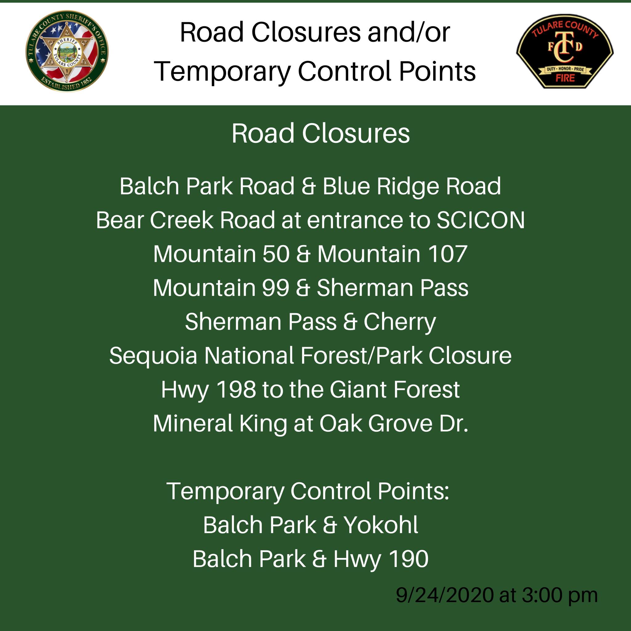
Road closures due to the SQF Complex may be found by clicking here.
The Temporary Flight Restriction (9/19/20) may be found here. Drones over the fire area are prohibited.
Sequoia National Park remains closed due to fire threat, including Generals Highway from Ash Mountain Entrance in Three Rivers to the Woodward Gate west.
Community Meetings: Scheduled for Sunday
Smoke: Current air quality may be found at https://fire.airnow.gov/.
Alert: To receive emergency notifications regarding evacuations and critical events sign up at alerttc.com.
Cooperating and Assisting Organizations: Tulare County Fire Department, Tulare County Sheriff’s Department, California Highway Patrol, Tule River Tribe, California Rehabilitation Center Fire Department, California Conservation Corps, California Office of Emergency Services, and Bureau of Land Management.
Safety Message: This will be a long duration event. Residents in the affected areas are encouraged to continue to prepare for the possibility of fire in their area in advance. Go to https://www.ready.gov/wildfires to learn how to prepare.
Sequoia Complex SQFComplex Update Wednesday September 23
Related Incident:
Publication Type: News
East Castle Zone SQF Complex
Sequoia and Inyo National Forests
September 23, 2020
California Interagency Incident Management Team 2 Mike Minton, Incident Commander
East Castle Zone Information Line: (559) 697-5148, 8 AM-8 PM
East Castle Zone Website: inciweb.nwcg.gov/incident/7048/
East Castle Zone Email: sqfcomplex2020@gmail.com
Facebook: www.facebook.com/SequoiaNF www.facebook.com/inyonf
Facebook: https://www.facebook.com/countyoftulare
Twitter: @sequoiaforest and @Inyo_NF
West Castle Zone Information Line: (916) 618-3195
West Castle Zone Media Line: (559) 635-8206
West Castle Zone Website: www.fire.ca.gov/current_incidents
West Castle Zone Email: calfiretulare@gmail.com
Facebook: @CALFIRE_TUU Twitter: @CALFIRETUU
All SQF Complex Statistics
Location: 25 miles N of Kernville, CA
Date of origin: 8/19/20
Cause: Lightning
Size: 144, 708 acres
Containment: 33%
Cost: $48 million
Injuries: 15
Structures threatened: 3,188
Structures destroyed: 191
Resources
Hand Crews: 19
Engines: 103
Water-tenders: 35
Dozers: 35
Helicopters: 9
Personnel: 1,458
Containment of the SQF Complex remains at 33%.
California Interagency Incident Management Team 2 assumed command of the East Castle Zone and Shotgun Fire today, at 7 AM. Mike Minton the incoming incident commander, thanks the Northern Rockies Incident Management Team 1 for their hard work and dedication and laying the groundwork for a successful Incident Management Team transition.
The SQF Complex is currently under Unified Command between the United States Forest Service, Sequoia National Park, California Interagency Incident Management Team 2, and CAL FIRE Team 6. CIIMT2 is in command of the East Castle Zone and CAL FIRE Team 6 is in command of the West Castle Zone.
SQF COMPLEX-ALL ZONES: The Castle Fire is 140,766 acres and the Shotgun Fire is 834 acres for a total of 141,600 acres.
East Castle Zone SQF Complex - Castle Fire: For over a week, all resource efforts were focused on the defensive tactic of providing structure protection. However, for the past two days, crews have been able to refocus efforts on constructing containment lines near the fire’s perimeter.
Today, work will continue in the areas near Ponderosa with the construction and improvement of containment lines to create a buffer around the community. Crews will provide structure protection as the potential for spot fires still exists. In Camp Nelson, firefighters will be patrolling the area looking for hot spots in an effort to eliminate threats from latent heat sources. Around the Tule Indian Reservation, crews will widen and improve containment lines.
Crews will also continue to patrol the communities in and around Alpine Village, Sequoia Crest, Cedar Slope, as residual heat sources remain a threat. Several fires, caused by blowing embers have been discovered and extinguished by patrolling crews as fire began to ignite exterior features of structures.
With no movement on portions of the southern and eastern flanks of the fire, containment remains at 33%. Air resources will continue to monitor these areas. On the northeast point, the fire continues backing to the west and is now one mile from Sequoia National Park. Backcountry structure protection groups remain ready to respond in the Casa Vieja Meadows area and direct line construction will continue in the Little Horse Meadows area.
Forecasted weather today brings the potential for active fire behavior on the entire perimeter. This will include surface fire activity with moderate rates of spread, single tree and group tree torching with spotting up to 1/2 mile.
Fire movement will primarily be on the southern end of the fire from Camp Nelson to the Kern River. Residual heat from the initial fire front continues to impact the communities of Cedar Slope, Alpine Village, Jordan Peak, and Sequoia Crest. Threats to structures/infrastructure include Peppermint Work Center, Camp Nelson, Pierpoint,
Ponderosa, Rogers Camp, Mountain Aire, and the Tule Indian Reservation. The east side of the fire continues to threaten infrastructure and physical assets at Osa, Beach, Casa Vieja and Beck Meadows as well as the US Geological Service seismic station, The Blackrock Ranger Station, and other infrastructure in the area. The cultural resources on Monache Mountain and in Monache Meadows will also be threatened. The fire in the Kern River Canyon on the north side will continue to threaten the Kern Canyon Ranger Station, private in-holdings and the Sequoia National Park. Overall fire growth is predicted to be the similar as the last 12 hours.
East Castle Zone SQF Complex - Shotgun Fire: There has been minimal growth on the fire; the fire is currently 834 acres.
Weather: The passage of a weak upper level trough brought deeper mixing and ventilation to the incident yesterday favoring greater smoke column depth and mix down of higher wind speeds to the surface. Winds were westerly 8 to 12 mph with gusts to 20 mph. The humidity minimum ranged from 15 to 20% with temperatures of 70 degrees (8000 feet elevation) to 85 degrees (5000 feet elevation). Concern last night was a west to northwest wind direction which is unfavorable for suppression and burnout operations. Lighter wind speeds are expected today and Thursday with a return to topographically driven wind speeds and direction. Low humidity is expected to persist. It is now day 110 since the fire area received over a tenth of an inch of rain.
Evacuations, Closures and Additional Information:
Kings Canyon National Park has been reopened as air quality has improved.
Sequoia National Park remains closed due to fire threat, including Generals Highway from Ash Mountain Entrance in Three Rivers to the Woodward Gate west
Tulare County residents are encouraged to sign up for emergency notifications at alerttc.com.
Evacuation Orders and Warnings Tulare County may be found at https://www.facebook.com/countyoftulare.
Tulare County has a structure assessment form for evacuees affected by the fire.
An interactive map showing damaged structures is now available.
Tulare County Health & Human Services Agency hotline for affected citizens – (559) 802-9790
The Red Cross has evacuation centers at Porterville Community College and the North Exeter Community Building. Also, call the Red Cross at 1-800-RED-CROSS or https://tinyurl.com/yafetgkj
Current air quality may be found at https://fire.airnow.gov/.
Sequoia and Inyo National Forests are closed: Regional Order No. 20-15
Regional Emergency Fire Restrictions are in place: Regional Order No. 20-14
The Bureau of Land Management Bakersfield Office has issued a temporary emergency closure.
Road closures due to the SQF Complex may be found by clicking here.
The Temporary Flight Restriction (9/19/20) may be found here. Drones over the fire area are prohibited.
Priorities include: Communities with evacuation orders and warnings, Casa Vieja, Blackrock Ranger Station, Rogers Camp, Beach Meadows, Monache Meadows, structures along the Lloyd Meadows Road, Freeman Grove, the President George H.W. Bush Tree, Camp Whitsett, archeological values, Mountain Yellow-Legged Frog and Little Kern Golden Trout Critical Habitats, Pacific Fisher habitats, OSA, Beach, and Beck Meadows, trailheads and facilities.
Cooperating Agencies: Tulare County Fire Department, Tulare County Sheriff’s Department, California Highway Patrol, Tule River Tribe, California Rehabilitation Center Fire Department, California Conservation Corps, California Office of Emergency Services, and Bureau of Land Management.
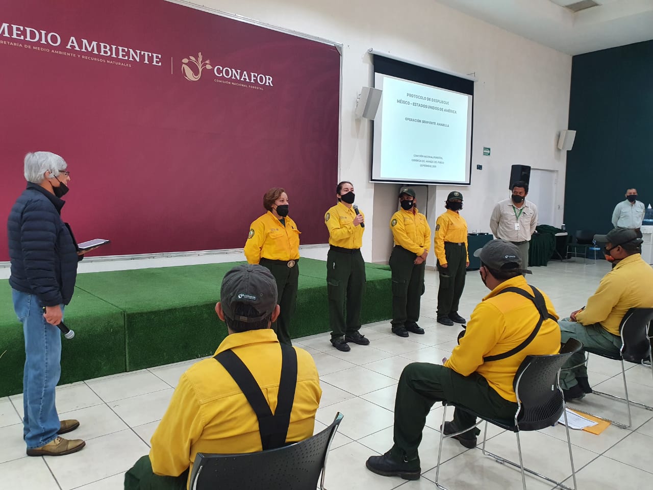
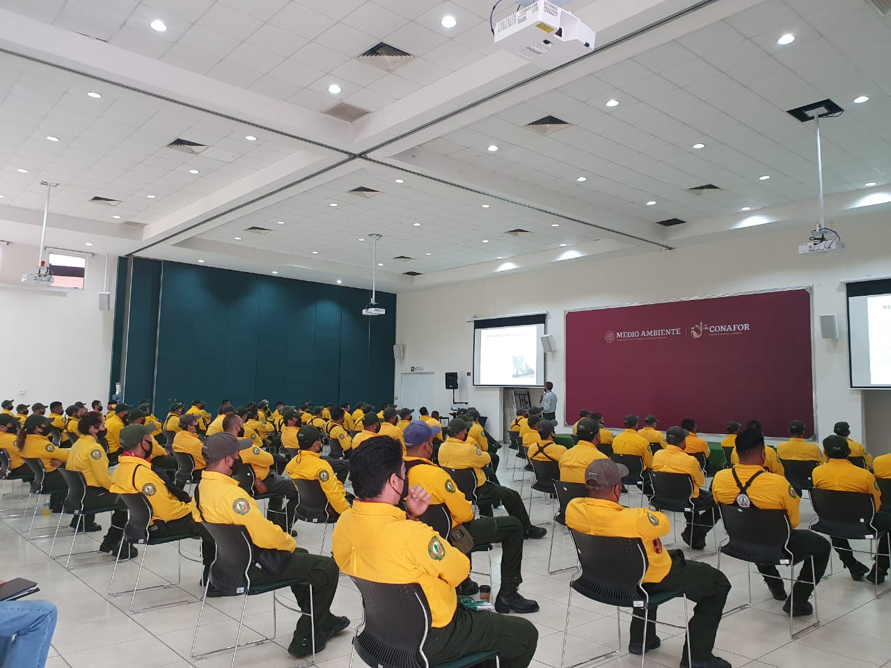
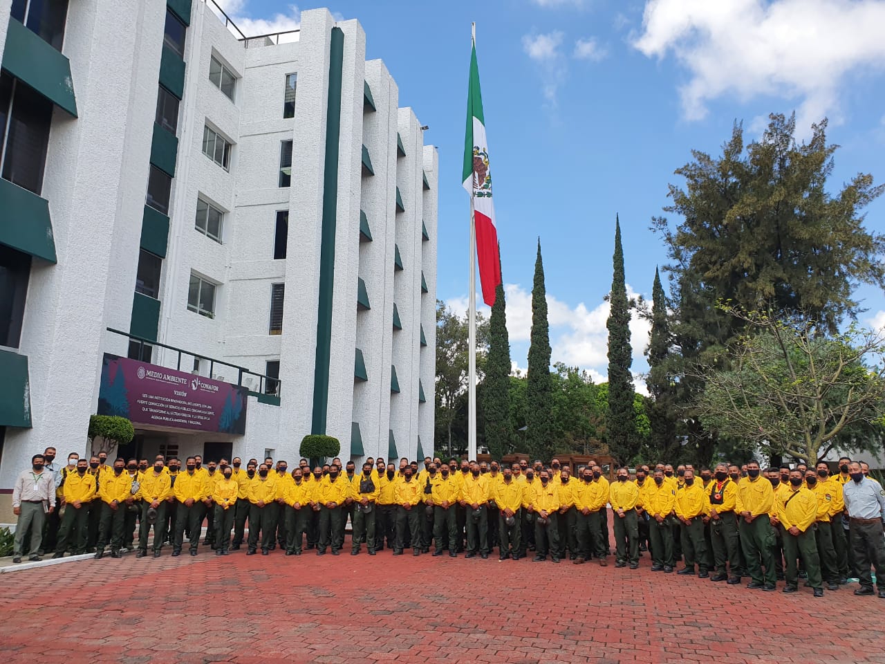
Forest Service mobilizes Mexico Fire Crews to provide Wildland Fire Support
Related Incident:
Publication Type: Announcement
Vallejo, CA – The USDA Forest Service (USFS) is mobilizing 100 wildland firefighters from across Mexico to assist with wildfire suppression efforts in California. Traveling from their homes throughout 22 states in Mexico, the crews will assemble in Guadalajara to board a chartered flight directly into California. The press is invited to a formal presentation and welcome event upon their arrival at the San Bernardino International Airport - a media advisory will be sent separately with details.
The Mexican firefighters, along with agency representatives, will arrive on Wednesday, September 23, 2020. After a welcome ceremony on Wednesday afternoon, they will receive an orientation and participate in fire shelter deployment and other refresher training over the next couple of days. Once the orientation is complete, the crews will take ground transportation to their fire assignment on the Castle Fire within the Sequoia Complex of fires on the Sequoia National Forest. The Sequoia Complex (#SQFComplex), is made up of the Castle and Shotgun fires. The lightning-caused fires were reported on August 24, 2020.
Since 1962, the USFS shares a long history of cooperation with Mexico in the area of fire management. The USFS has provided training to and assisted Mexico with strengthening capacity in fire management beginning in 1983. The Forest Service brings its extensive skill in fire planning, capacity building and research and its practical application to fire issues.
Eduardo Cruz, the current director of CONAFOR (National Forestry Commission of Mexico), spent one seasons as a helitack firefighter on the Sequoia National Forest early in his career as part of the training and exchange program. "I am very excited for this unique opportunity to visit a station I worked and trained at as a young man and to bring with me firefighters from Mexico to aid in the California firefighting effort".
Currently, 23 large wildfires are burning across California and 8,300 wildfires have burned over 2.5 million acres in the state this year. Firefighters from both Canada and Mexico and the U.S. military are now deployed to incidents around the state during this period of peak fire activity.
A media event will be held tomorrow, September 23, 2020, at the San Bernardino International Airport Terminal to welcome firefighters from Mexico coming to help battle California fires.
The plane will land at approximately 1:45 p.m. (opportunity for b-roll as firefighters and dignitaries de-plane). The formal event will begin at 2:30 p.m., once customs has been cleared. Individual interviews with officials will be accommodated both before and after the formal program.
Address: San Bernardino International Airport- Luxivair SBD
295 N Leland Norton Way, San Bernardino, CA 92408
RSVP: Julissa Gonzalez c: 805-680-4559, julissa.gonzalez@usda.gov
Officials that will be speaking/present:
National Forestry Commission of Mexico (CONAFOR)
- • Ramón Silva Flores, deputy chief of Conservation and Restoration for CONAFOR;
- • Eduardo Cruz Castañeda, national fire management director of CONAFOR;
- • Taryn Sánchez Montesinos, CONAFOR International Affairs Officer; and
- • Several firefighters and crew bosses of the 100 that are coming from Mexico.
USDA Forest Service (USFS)
- • Anthony Scardina, deputy regional forester of the Pacific Southwest Region, USFS;
- • Kim Christensen, deputy assistant director of operations, USFS; and
- • Brian Rhodes, deputy director for Fire and Aviation Management of the Pacific Southwest Region, USFS.
Smoke Outlook for Sequoia Complex SQFComplex Update Wednesday Sept 23
Related Incident:
Publication Type: News
Smoke
Air quality across the outlook area is expected to remain unhealthy with weaker SW winds resulting in lingering smoke west of the fire during the day. Air quality alerts have been issued within this Outlook area for more information reference the link below.
Special Notes
Outlooks values reflect 24hr particulate matter impacts on air quality. Review your closest monitoring station when planning outdoor activities and review the links below for further information.
Hours at Temp Evac Points Livestock Shelters Change 92320
Related Incident:
Publication Type: Announcement
VISALIA, CA – As of September 23, 2020, the Temporary Evacuation Points, livestock evacuation shelters, and Animal Services are amending their hours due to the SQF Complex fire activity. The temporary evacuation points at the Exeter Memorial Building and the Porterville College Football field are amending their hours of operation to Monday through Sunday, 8:00 a.m.-5:00 p.m.
The Tulare County Animal Services livestock evacuation shelters at Woodlake Rodeo Grounds, Porterville Fairgrounds, and Tulare County Animal Service's main shelter will be open to owners wishing to pick-up, drop-off, or visit their evacuated animals between the hours of 8:00 a.m. and 5:00 p.m. Monday through Sunday. Owners are encouraged to call (559) 636-4050 in advance to arrange pick-up or drop-off.
For other Animal Services related services including Animal Control functions, stray dog drop-offs, licensing and other administrative functions, phone hours are Monday through Saturday 8:00 a.m. to 5:00 p.m., with shelter operation hours Monday through Saturday from 10:00 a.m. to 4:00 p.m. The shelter is closed to normal operations on Sunday.
Smoke Outlook for Sequoia Complex SQFComplex Tue Sept 22
Related Incident:
Publication Type: News
Smoke
Air quality across the outlook area is expected to remain
unhealthy with a few areas of moderate. With burnout
operations underway, smoke may increase at times. However,
most smoke should remain within the Sierras. Evening down
drainage flow will transport smoke back into the valleys.
Special Notes
Outlooks values reflect 24hr particulate matter impacts on air
quality. Review your closest monitoring station when planning
outdoor activities and review the links below for further
information.
Sequoia Complex SQFComplex Update Tuesday September 22
Related Incident:
Publication Type: News
East Castle Zone SQF Complex
Sequoia and Inyo National Forests
September 22, 2020
Northern Rockies Incident Management Team 1
Mike Goicoechea, Incident Commander
East Castle Zone Information Line: (559) 697-5148, 8 AM-8 PM
East Castle Zone Website: inciweb.nwcg.gov/incident/7048/
East Castle Zone Email: sqfcomplex2020@gmail.com
Facebook: www.facebook.com/SequoiaNF www.facebook.com/inyonf
Facebook: https://www.facebook.com/countyoftulare
Twitter: @sequoiaforest and @Inyo_NF
West Castle Zone Information Line: (916) 618-3195
West Castle Zone Media Line: (559) 635-8206
West Castle Zone Website: www.fire.ca.gov/current_incidents
West Castle Zone Email: calfiretulare@gmail.com
Facebook: @CALFIRE_TUU Twitter: @CALFIRETUU
All SQF Complex Statistics
Location: 25 miles N of Kernville, CA
Date of origin: 8/19/20
Cause: Lightning
Size: 141,600 acres
Containment: 33%
Cost: $44.1 million
Injuries: 15
Civilians evacuated: 3,491
Structures threatened: 3,183
Structures destroyed: 184
Resources
Hand Crews: 19
Engines: 96
Water-tenders: 36
Dozers: 34
Helicopters: 9
Personnel: 1,422
Containment of the SQF Complex is now 33%, an increase of 15% from yesterday’s report. Increase in structures lost is not primary residences. The increase is to account for structures used for a variety of purposes other than dwelling.
The Northern Rockies Incident Management Team 1 will transfer command of the East Castle Zone and Shotgun Fire to California Team 2 at 7 AM on September 23, 2020. “The incoming incident commander, Mike Minton, is familiar with the Sequoia National Forest, and knows some of the local agency administrators,” said Mike Goicoechea. “I am confident that this transfer will in no way have a negative effect on the ground firefighting efforts. I have full confidence that the new team will continue to protect communities and add additional containment lines to the fire.”
The SQF Complex is currently under Unified Command between the United States Forest Service, Sequoia National Park, Northern Rockies Incident Management Team 1, and CAL FIRE Team 6. Northern Rockies Team 1 is in command of the East Castle Zone (until 7 AM on September 23) and CAL FIRE Team 6 is in command of the West Castle Zone.
SQF COMPLEX-ALL ZONES: The Castle Fire is 140,766 acres and the Shotgun Fire is 834 acres for a total of 141,600 acres.
East Castle Zone SQF Complex - Castle Fire: For over a week, all efforts of firefighters have been focused on the defensive tactic of providing structure protection. Yesterday, crews were able to focus efforts on containment and line construction near the fire’s perimeter.
Today, work continues in the area near Ponderosa with the construction and improvement of line to buffer the community from threat of a fire front or spotting fire. Indirect line construction will continue south of Pierpoint towards a rocky outcrop that will serve as anchor. In Camp Nelson, firefighters will hotspot to eliminate threats from latent heat sources. Around the Tule Indian Reservation, crews will look to widen and improve the line along the ridge.
Where the fire front has already passed, crews will continue their patrol of Alpine Village, Sequoia Crest, Cedar Slope, and points in-between as residual heat sources remain a threat.
With no movement on portions of the southern and eastern flanks of the fire, containment has increased to 33%. Fire perimeters will continue to be monitored by air resources. On the northeast point, the fire continues backing to the west and is now one mile from Sequoia National Park. Backcountry structure protection groups remain ready to respond in the Casa Vieja Meadows area. Direct line construction will continue in the Little Horse Meadows area.
Air resources have played an integral part of daily firefighting operations on the Sequoia Complex. Since the Northern Rockies Incident Management Team has managed the fire on September 3, there have been a total of 1,670 hours of flying time. During this time, 1.4 million gallons of water and 1.5 million gallons of retardant have been dropped on the fire. Eighty-eight thousand pounds of cargo has also been hauled to support fire operations.
East Castle Zone SQF Complex - Shotgun Fire: Minimal growth on the fire continues; the fire is currently 834 acres.
Weather: Slightly cooler temperatures will be over the fire area with highs between 75-82 degrees. Relative humidity levels will increase to around 16%. Winds will gust on the ridgetops out of the west. The next few days will bring little weather change, with no rain in the forecast. It is now day 109 since the fire area received over a tenth of an inch of rain.
Evacuations, Closures and Additional Information:
- Tulare County residents are encouraged to sign up for emergency notifications at alerttc.com.
- Evacuation Orders and Warnings Tulare County may be found at https://www.facebook.com/countyoftulare.
- Tulare County has a structure assessment form for evacuees affected by the fire.
- An interactive map showing damaged structures is now available.
- Tulare County Health & Human Services Agency hotline for affected citizens – (559) 802-9790
- The Red Cross has evacuation centers at Porterville Community College and the North Exeter Community Building. Also, call the Red Cross at 1-800-RED-CROSS or https://tinyurl.com/yafetgkj
- Current air quality may be found at https://fire.airnow.gov/.
- Sequoia and Inyo National Forests are closed: Regional Order No. 20-15
- Regional Emergency Fire Restrictions are in place: Regional Order No. 20-14
- Sequoia and Kings Canyon National Parks are currently closed.
- The Bureau of Land Management Bakersfield Office has issued a temporary emergency closure.
- Road closures due to the SQF Complex may be found by clicking here.
- The Temporary Flight Restriction (9/19/20) may be found here. Drones over the fire area are prohibited.
Priorities include: Communities with evacuation orders and warnings, Casa Vieja, Blackrock Ranger Station, Rogers Camp, Beach Meadows, Monache Meadows, structures along the Lloyd Meadows Road, Freeman Grove, the President George H.W. Bush Tree, Camp Whitsett, archeological values, Mountain Yellow-Legged Frog and Little Kern Golden Trout Critical Habitats, Pacific Fisher habitats, OSA, Beach, and Beck Meadows, trailheads and facilities.
Cooperating Agencies: Tulare County Fire Department, Tulare County Sheriff’s Department, California Highway Patrol, Tule River Tribe, California Rehabilitation Center Fire Department, California Conservation Corps, California Office of Emergency Services, and Bureau of Land Management.
Sequoia Complex SQFComplex Update Monday September 21
Related Incident:
Publication Type: News
East Castle Zone SQF Complex
Sequoia and Inyo National Forests
September 21, 2020
Northern Rockies Incident Management Team 1
Mike Goicoechea
East Castle Zone Information Line: (559) 697-5148, 8 AM-8 PM
East Castle Zone Website: inciweb.nwcg.gov/incident/7048/
East Castle Zone Email: sqfcomplex2020@gmail.com
Facebook: www.facebook.com/SequoiaNF www.facebook.com/inyonf
Facebook: https://www.facebook.com/countyoftulare
Twitter: @sequoiaforest and @Inyo_NF
West Castle Zone Information Line: (916) 618-3195
West Castle Zone Media Line: (559) 635-8206
West Castle Zone Website: www.fire.ca.gov/current_incidents
West Castle Zone Email: calfiretulare@gmail.com
Facebook: @CALFIRE_TUU Twitter: @CALFIRETUU
All SQF Complex Statistics
Location: 25 miles N of Kernville, CA
Date of origin: 8/19/20
Cause: Lightning
Size: 137,508 acres
Containment: 18%
Cost: $41.1 million
Injuries: 14
Civilians evacuated: 3,491
Structures threatened: 3,183
Structures destroyed: 150
ResourcesHand Crews: 19
Engines: 104
Water-tenders: 37
Dozers: 28
Helicopters: 7
Personnel: 1,440
The SQF Complex is under Unified Command between the United States Forest Service, Sequoia National Park, Northern Rockies Incident Management Team 1, and CAL FIRE Team 6. The Northern Rockies Team 1 is in command of the East Castle Zone and CAL FIRE Team 6 is in command of the West Castle Zone. On September 23, California Team 2 will take command of the East Castle Zone.
“We are still in a battle, all day and through the night, to protect local homes,” said Mike Goicoechea, Incident Commander. “We are continuing to patrol areas where fire has moved through. On a daily basis, firefighters are making saves on homes by preventing spots from getting established near structures. We remain in an active, dangerous area.”
SQF COMPLEX-ALL ZONES: Containment on the complex has increased to 18%. The Castle Fire is 136,675 acres and the Shotgun Fire is 833 acres for a total of 137,508 acres.
East Castle Zone SQF Complex - Castle Fire: Yesterday, fire crews continued building a containment box around Ponderosa to buffer it from the threat of fire. By building a wide, defensible line, crews are ensuring that they have the best chance of stopping the fire’s progression and catching spot fires if they occur. East of Ponderosa towards the Kern River, retardant was dropped from fixed wing and rotor wing aircraft to stop the southern progression of the fire. These actions will continue today. When imminent threats to homes has lessened, work will move from point protection and structure defense to perimeter control using direct and indirect tactics.
On the southwest corner, crews are working to keep fire from establishing on the eastern side of Coy Flat Road. Despite fire spotting and rollout from logs firefighters’ efforts has been successful. Work will continue today to tie this line southeast of the road towards a rocky outcrop. In Mountain Aire and Camp Rodgers, sprinklers and hose lays are being installed around the community. Dozer line will be constructed around these areas as well to support point protection.
Firefighters continue their patrol of where the fire front has already passed in Alpine Village, Sequoia Crest and Cedar Slop. Embers and residual heat sources are still a threat to structures in these communities.
Containment on the fire is now 18% as portions along the southern and eastern flanks of the fire have not had fire movement or heat. An uncontained area remains on the southeast, to the north of Beach Meadows. Work in this area is being completed, using a combination of crews, engines, and heavy equipment. Back country groups have completed preparing and planning and will implement plans if needed.
East Castle Zone SQF Complex - Shotgun Fire: Minimal growth on the fire is expected, the fire is currently 833 acres.
Weather: Temperatures will be slightly higher today, ranging from 77-84 degrees. Relative humidity levels will be similar to yesterday, in the 12-16% for the anticipated lows. Winds will gust southwest along the ridges to 17 mph.
Evacuations, Closures and Additional Information:
- Tulare County residents are encouraged to sign up for emergency notifications at alerttc.com.
- Evacuation Orders and Warnings Tulare County may be found at https://www.facebook.com/countyoftulare.
- Tulare County has a structure assessment form for evacuees affected by the fire.
- An interactive map showing damaged structures is now available.
- Tulare County Health & Human Services Agency hotline for affected citizens – (559) 802-9790
- The Red Cross has evacuation centers at Porterville Community College and the North Exeter Community Building. Also, call the Red Cross at 1-800-RED-CROSS or https://tinyurl.com/yafetgkj
- Current air quality may be found at https://fire.airnow.gov/.
- Sequoia and Inyo National Forests are closed: Regional Order No. 20-15
- Regional Emergency Fire Restrictions are in place: Regional Order No. 20-14
- Sequoia and Kings Canyon National Parks are currently closed.
- The Bureau of Land Management Bakersfield Office has issued a temporary emergency closure.
- Road closures due to the SQF Complex may be found by clicking here.
- The Temporary Flight Restriction (9/19/20) may be found here. Drones over the fire area are prohibited.
Priorities include: Communities with evacuation orders and warnings, Casa Vieja, Blackrock Ranger Station, Rogers Camp, Beach Meadows, Monache Meadows, structures along the Lloyd Meadows Road, Freeman Grove, the President George H.W. Bush Tree, Camp Whitsett, archeological values, Mountain Yellow-Legged Frog and Little Kern Golden Trout Critical Habitats, Pacific Fisher habitats, OSA, Beach, and Beck Meadows, trailheads and facilities.
Cooperating Agencies: Tulare County Fire Department, Tulare County Sheriff’s Department, California Highway Patrol, Tule River Tribe, California Rehabilitation Center Fire Department, California Conservation Corps, California Office of Emergency Services, and Bureau of Land Management.