
Mandatory Evacuation Orders for Silver City and Mineral King
Related Incident:
Publication Type: Announcement
County of Tulare
September 18, 2020
Tulare County Issues Mandatory Evacuation Orders for Silver City and Mineral King
VISALIA, CA – The Tulare County Sheriff has issued a mandatory evacuation order for Silver City and Mineral King, effective immediately, due to the SQF Complex fire activity.
Mandatory evacuation means an immediate threat to life safety and property; all residents must evacuate the area.
The temporary evacuation points are at the Exeter Memorial Building, 324 N. Kaweah in Exeter and the Porterville College football stadium at 100 E College Ave in Porterville. Displaced persons should call 2-1-1 and/or 1-800-RED-CROSS to obtain shelter; for those who have RVs/trailers to park, please also call 2-1-1. If you are an older individual who may need assistance evacuating, please call 1-800-321-2462.
As you are able, please evacuate your domestic animals with you. Should you need to evacuate livestock, bring them to either the Woodlake Lions Club Rodeo Grounds or the Porterville Fairgrounds
If you need shelter for your domestic animals, call Tulare County Animal Shelter Manager Cassandra Heffington, Manager, at (559) 679-6222, the shelter location is 14131 Avenue 256, Visalia, CA 93292 and staff are there to assist you.
If you have to evacuate your property and leave animals behind, please fill out this form and Tulare County Animal Services will contact you between the hours of 8:00 AM and 8:00 PM to coordinate care for your animals. If it is not safe to return to your address, Animal Services will try and shelter in place for the animals and you will be kept on their list to follow up as soon as it is safe to do so. https://tcanimalservices.org/animalservices/resources/animal-evacuation-form/
Tulare County has two levels of evacuations: voluntary and mandatory. The following communities remain under mandatory evacuation orders: Ponderosa, Pyles Boys Camp; Redwood Dr.; Alpine Village; South Fork; Sequoia Crest; Doyle Springs; Highway 190 along the south from the intersection of Balch Park Rd. north to Blue Ridge Lookout east to Moses Mountain, and south to Highway 190 at Mahogany Flat, Upper Tule River Corridor (Camp Nelson, Pierpoint, Coy Flat, Mountain Aire, and points between); Cedar Slope;
The following communities remain under voluntary evacuation: Community of Springville, all points between Globe Drive and Balch Park Rd.
Forest Service to Increase Access to National Forests in California
Related Incident:
Publication Type: Announcement
U.S. Forest Service
Pacific Southwest Region
1323 Club Drive
Vallejo, CA 94591
https://www.fs.usda.gov/r5/
News Release
FOR IMMEDIATE RELEASE
September 18, 2020
Public Inquiry Line: (707) 562-9113
Media Contact: Jonathan Groveman (707) 562-8995
jonathan.groveman@usda.gov
VALLEJO, Calif. – The USDA Forest Service Pacific Southwest Region announces increased access to some National Forests in California beginning at 8:00 a.m. on Saturday, September 19, 2020.
The prohibition of the use of any ignition source on all National Forest System lands (campfires, gas stoves, etc.) throughout California remains in place.
Nine National Forests in California remain closed: Angeles NF, Cleveland NF, Los Padres NF, Inyo NF, Klamath NF, San Bernardino NF, Sequoia NF, Sierra NF, and Six Rivers NF. This decision will continue to be reviewed daily with evolving fire and weather conditions.
Nine other National Forests may open to varying degrees. Visitors should contact the following National Forests for more information on their status: Eldorado NF, Lake Tahoe Basin Management Unit, Lassen NF, Mendocino NF, Modoc NF, Plumas NF, Shasta-Trinity NF, Stanislaus NF, and the Tahoe NF. These forests will implement their own forest orders that will either limit dispersed use or provide for area closures around fires.
Conditions can change quickly. Therefore, we emphasize that all citizens heed local announcements for changes in conditions and potential evacuations.
"We understand how important access to the National Forests is to our visitors," said Randy Moore, Regional Forester for the USDA Forest Service Pacific Southwest Region. "Continued closures are essential based on extreme fire conditions, critical limitations of firefighting resources, and to provide for firefighter and public safety.”
Again, visitors are encouraged to contact their local National Forest for more information. We have developed a web map to help visitors find out which sites are open. Visit our online map at https://www.fs.fed.us/r5/webmaps/RecreationSiteStatus/. For additional questions, please contact your local National Forest.
The Forest Service manages 18 National Forests in the Pacific Southwest Region, which encompasses over 20 million acres across California, and assists State and Private forest landowners in California, Hawaii and the U.S. Affiliated Pacific Islands. National forests supply 50 percent of the water in California and form the watershed of most major aqueducts and more than 2,400 reservoirs throughout the state. For more information, visit www.fs.usda.gov/R5.
Sequoia Complex SQFComplex Update Friday September 18
Related Incident:
Publication Type: News
East Castle Zone SQF Complex
Sequoia and Inyo National Forests
September 18, 2020
Northern Rockies Incident Management Team 1
Mike Goicoechea, Incident Commander
East Castle Zone Information Line: (559) 697-5148, 8 AM-8 PM
East Castle Zone Website: inciweb.nwcg.gov/incident/7048/
East Castle Zone Email: sqfcomplex2020@gmail.com
Website: inciweb.nwcg.gov/incident/7048/
Facebook: www.facebook.com/SequoiaNF www.facebook.com/inyonf
Facebook: https://www.facebook.com/countyoftulare
Twitter: @sequoiaforest and @Inyo_NF
Evacuation Info: www.alerttc.com
West Castle Zone Information Line: (916) 618-3195
West Castle Zone Media Line: (559) 635-8206
West Castle Zone Website: www.fire.ca.gov/current_incidents
West Castle Zone Email Updates (sign up): https://tinyurl.com/SQFComplexWest
Evacuation Info: www.alerttc.com
Facebook: @CALFIRE_TUU Twitter: @CALFIRETUU
All SQF Complex Statistics
Location: 25 miles N of Kernville, CA
Date of origin: 8/19/20
Cause: Lightning
Size: 128,902 acres
Containment: 12%
Cost: $35.6 million
Injuries: 14
Civilians evacuated: 3,183
Structures threatened: 3,483
Structures destroyed: 150
Resources
Hand Crews: 23
Engines: 92
Water-tenders: 31
Dozers: 24
Helicopters: 7
Personnel: 1,384
The Sequoia Complex (#SQFComplex) is under the Unified Command between the United States Forest Service, Sequoia National Park, Northern Rockies Incident Management Team 1, and CAL FIRE Team 6. The Northern Rockies Team 1 is in command of the East Castle Zone and CAL FIRE Team 6 is in command of the West Castle Zone on the SQF Complex.
“Our firefighters have put many hours, many days, into the firefight around local communities,” said Mike Goicoechea. “We realize that we still have tough days ahead of us, but we are going to put the work in to provide the best protection for local communities. At the same time, our number one priority will be to provide for firefighter and public safety. We will continue to work as One Team, in our fight on this fire.”
A community meeting will be held at 4 PM on Sunday, September 20, for both the West and East Zones of the Sequoia Complex. The meeting will be held via Facebook Live on the Sequoia National Forest’s Facebook page. Questions for the East Castle Zone may be submitted in advance to: sqfcomplex2020@gmail.com.
SQF COMPLEX-ALL ZONES: The entire complex is a total of 128,902 acres and contains the Castle Fire (128,072 acres) and the Shotgun Fire (830 acres). The complex is currently 12% contained.
East Castle Zone SQF Complex - Castle Fire: Yesterday, winds out of the southwest challenged firefighters working in local communities, throwing embers and creating spot fires throughout the day. At the start of shift, active fire and spotting began in Camp Nelson. Fire activity picked up shortly after in the Coy Flat and Pierpoint areas. Work in Ponderosa continues to be busy, but successful, with no homes currently lost.
Helicopters continue to assist in the air as crews battle the fire on the ground. To date, a total of 1.3 million gallons of water and retardant have been used to protect communities. Due to terrain and fuel loading, firefighters are often working close to structures, at times, literally from patios and decks.
Residual heat and embers may cause threats to structures after the fire front has passed. Crews continue to patrol communities where fire has already passed through and actively implement structure protection as needed. While on patrol yesterday in the Sequoia Crest area, crews were alerted to a home affected by residual heat and embers and implemented structure protection measures to save the home.
Today, Point protection will continue in all communities and is the top priority. Firefighters are working through the day and night, providing structure protection and creating defensible space. Shifting winds today from the southwest to west will be a change that will challenge current firelines. Firefighter and public safety are our number one priority and strategies will be implemented to protect life safety.
Fire crews will continue to mop up the area near Lion Meadows and react to any spot fires created by Friday’s western winds. Although fire activity has been minimal, backcountry crews remain ready on the Inyo National Forest. Personnel from Sequoia National Park remain at the Kern Canyon Ranger Station to provide structure protection if needed.
East Castle Zone SQF Complex - Shotgun Fire: The fire is approximately one mile south of the Sequoia National Park and is currently 830 acres.
Weather: Mostly cloudy skies will prevail over the fire area on Friday with gusty winds out of the west-southwest. Relative humidity levels will increase from previous days ranging from the upper teens to the upper 20s. Clearer skies are expected in the area on Saturday, along with cooler temperatures.
Smoke: Smoke will lift from the Kern River Valley around noon and heavily return this evening. For current air quality, visit: https://fire.airnow.gov/.
Evacuations, Closures and Additional Information:
- Tulare County has a structure assessment form for evacuees affected by the fire.
- Evacuation Orders and Warnings Tulare County may be found at https://www.facebook.com/countyoftulare.
- Tulare County residents are encouraged to sign up for emergency notifications at alerttc.com.
- The Red Cross has evacuation centers at Porterville Community College and the North Exeter Community Building. Also, call the Red Cross at 1-800-RED-CROSS or https://tinyurl.com/yafetgkj
- All National Forests in California are currently closed as of September 9, 2020.
- Sequoia and Kings Canyon National Parks are currently closed.
- The Bureau of Land Management Bakersfield Office has issued a temporary emergency closure.
- Road closures due to the SQF Complex may be found by clicking here.
- The current Temporary Flight Restriction (9/15/20) may be found by clicking here. The use of drones over the fire is also prohibited.
Priorities include: Communities listed in the above evacuation orders, Casa Vieja, Blackrock Ranger Station, Rogers Camp, Beach Meadows, Monache Meadows, structures along the Lloyd Meadows Road, Freeman Grove, the President George H.W. Bush Tree, Camp Whitsett, archeological values, Mountain Yellow-Legged Frog and Little Kern Golden Trout Critical Habitats, Pacific Fisher habitats, OSA, Beach, and Beck Meadows, trailheads and facilities.
Cooperating Agencies: Tulare County Fire Department, Tulare County Sheriff’s Department, California Highway Patrol, Tule River Tribe, California Rehabilitation Center Fire Department, California Conservation Corps, California Office of Emergency Services.
Smoke Outlook for Sequoia Complex SQFComplex Friday Sept 18
Related Incident:
Publication Type: News
Smoke Outlook for 9/18 - 9/19
Southern Sierra - Sequoia : SQF Complex
Issued at: 2020-09-18 08:16 PDT
Smoke
Yesterday, the air quality was mostly Unhealthy. The exception
was the south boundary communities of Sequoia N. P. These
were as high as Hazardous. Today it is a mix. The morning
smoke levels will not lower until the afternoon strong WSW
ridge winds appear. However, these also contribute smoke to
Owens Valley and Kennedy Meadows. Tonight all impacted
drainages will collect smoke at higher levels as cooler night
temperatures & humidity increase fuel smoldering. Saturday
brings again WSW ridge winds. This will continue to lower
smoke levels in San Joaquin Valley and Sierra Foothills.
Special Notes
Outlooks reflect particulate matter impacts on air quality.
Review your closest monitoring station when planning outdoor
activities. Roadway Visibility can be affected. Drive with care.
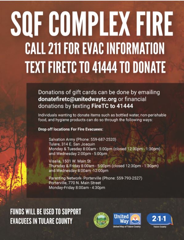
Tulare County Provides Advice About Donations for Evacuees
Related Incident:
Publication Type: Announcement
NEW DROPOFF IN PORTERVILLE! Individuals wanting to donate items such as bottled water, non-perishable food, and hygiene products can do so through the following ways: Drop off locations
For Fire Evacuees: Salvation Army (Phone: 559-687-2520)
Tulare (Monday & Tuesday 8-5 pm (closed 12:30-1:30 pm) and Wednesday 2-5 pm) 314 E. San Joaquin
Visalia (Thursday & Friday 8-5 pm (closed 12:30-1:30 pm) and Wednesday 8am -12 pm) 1501 W. Main St
Parenting Network- Porterville (Phone: 559-793-2527) Porterville (M-F 8:00 am -4:30 pm) 770 N. Main Street
When a fire evacuee needs essential supplies like water, food, clothing and gift cards they can do so by emailing fire@unitedwaytc.org, calling 211 or by filling out the following form: https://bit.ly/3muj4Gb Salvation Army and Parenting Network will receive these referrals.
Sequoia Complex SQFComplex Update Thurs Sept 17
Related Incident:
Publication Type: News
East Castle Zone SQF Complex
Sequoia and Inyo National Forests
September 17, 2020
Northern Rockies Incident Management Team 1
Mike Goicoechea, Incident Commander
East Castle Zone Information Line: (559) 697-5148, 8 AM-8 PM
East Castle Zone Website: inciweb.nwcg.gov/incident/7048/
East Castle Zone Email: sqfcomplex2020@gmail.com
Website: inciweb.nwcg.gov/incident/7048/
Facebook: www.facebook.com/SequoiaNF www.facebook.com/inyonf
Facebook: https://www.facebook.com/countyoftulare
Twitter: @sequoiaforest and @Inyo_NF
Evacuation Info: www.alerttc.com
West Castle Zone Information Line: (916) 618-3195
West Castle Zone Media Line: (559) 635-8206
West Castle Zone Website: www.fire.ca.gov/current_incidents
West Castle Zone Email Updates (sign up): https://tinyurl.com/SQFComplexWest
Evacuation Info: www.alerttc.com
All SQF Complex Statistics
Location: 25 miles N of Kernville, CA
Date of origin: 8/19/20
Cause: Lightning
Size: 122,835 acres
Containment: 12%
Cost: $32.5 million
Injuries: 14
Civilians evacuated: 3,183
Structures threatened: 3,483
Structures destroyed: 150
Resources
Hand Crews: 20
Engines: 73
Water-tenders: 27
Dozers: 19
Helicopters: 14
Personnel: 1,260
The Sequoia Complex (#SQFComplex) is under the Unified Command between the United States Forest Service, Sequoia National Park, Northern Rockies Incident Management Team 1, and CAL FIRE Team 6. Firefighter and public safety are the number one priority as we continue to battle this blaze. Although the fire perimeter is divided into a West Zone and an East Zone we come together as ONE Team to share resources and implement strategies to protect life safety and values at risk.
Tulare County has a structure assessment form for people who are affected by the SQF Complex. The purpose of the form is so county officials will have citizen’s contact information and can be contacted as quickly as information is available. Be advised damage assessment will begin as soon as it is safe for personnel to enter the area.
The Northern Rockies Team 1 (East Castle Zone) and CAL FIRE Team 6 (West Castle Zone) are in Unified Command of the SQF Complex. “Both of our teams have firefighter and public safety as our number one priority,” said Mike Goicoechea “We are providing point protection in our communities and have operations running 24 hours a day on the fireline. Our crews are making every effort to defend structures with firefighters on the ground as well as in the air.” This has been a 24/7 fire fight around homes.
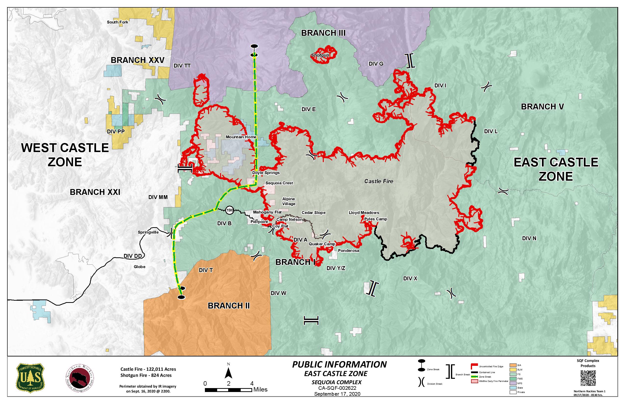
SQF COMPLEX-ALL ZONES: The entire complex is a total of 122,835 acres and contains the Castle Fire (122,011 acres) and the Shotgun Fire (824 acres), The complex is currently 12% contained.
East Castle Zone SQF Complex - Castle Fire: Point protection of structures in all communities will continue to be the top priority in the upcoming days and nights. The southwest corner of the fire has continued to experience active fire behavior through the night and early in the day, due to extremely low humidity levels during the day and poor overnight humidity recoveries. Firefighters are working night operations to provide as much protection for area communities as they are able.
Yesterday, the fire ran towards Ponderosa from the northwest and northeast, with multiple spot fires. Firing operations were used to increase a black defensive line around Ponderosa. In Quaker Meadow, the fire spotted south as it moved toward Peppermint. Active fire is on both sides of highway 190.
If conditions are appropriate Today, burnout operations will be implemented on the east side of Ponderosa.
Structure protection in the Kern Canyon Ranger Station area has been turned over to local fire personnel in Sequoia National Park. Further southeast, there was a ten-acre spot fire near Little Horse Meadows. Firefighters worked through the night to secure the area. Today, they will continue working direct near Lion Meadows to secure this fire finger.
East Castle Zone SQF Complex - Shotgun Fire: The fire continues to exhibit low intensity surface fire and is currently 824 acres.
Weather: An upper level disturbance will begin to move across the fire which will bring southwest winds and an increase in clouds. High temperatures will range from 80-89 degrees and humidity levels will be as low as 7-10%.
Smoke: Smoke will lift from the Kern River Valley by mid-morning and heavily return this evening. For current air quality, visit: https://fire.airnow.gov/.
Evacuations and Closures:
- Evacuation Orders and Warnings Tulare County may be found at https://www.facebook.com/countyoftulare.
- Tulare County residents are encouraged to sign up for emergency notifications at alerttc.com.
- The Red Cross has evacuation centers at Porterville Community College and the North Exeter Community Building. Also, call the Red Cross at 1-800-RED-CROSS or https://tinyurl.com/yafetgkj
- All National Forests in California are currently closed as of September 9, 2020.
- Sequoia National Park has a full park closure, Kings Canyon National Park remains open at this time.
- The Bureau of Land Management Bakersfield Office has issued a temporary emergency closure.
- For current information on California Highways, visit https://dot.ca.gov/ . Other road closures may be in effect.
- The current Temporary Flight Restriction (9/15/20) may be found by clicking here. The use of drones over the fire is also prohibited.
Priorities include: Communities listed in the above evacuation orders, Casa Vieja, Blackrock Ranger Station, Rogers Camp, Beach Meadows, Monache Meadows, structures along the Lloyd Meadows Road, Freeman Grove, the President George H.W. Bush Tree, Camp Whitsett, archeological values, Mountain Yellow-Legged Frog and Little Kern Golden Trout Critical Habitats, Pacific Fisher habitats, OSA, Beach, and Beck Meadows, trailheads and facilities.
Sequoia Complex SQFComplex Smoke Outlook Thurs Sept 17
Related Incident:
Publication Type: News
Smoke Outlook for 9/17 - 9/18
Southern Sierra - Sequoia : SQF Complex
Issued at: 2020-09-17 08:22 PDT
Smoke
Yesterday, the air quality was mostly unhealthy. The exception
was Keeler and Kennedy Meadows. Today, air quality is
projected to deteriorate further especially for Giant Forest, Ash
Mtn., & Mineral King. Tule River and Kerr River drainages are
the conduits & collection spaces of area smoke. On Friday,
ridge winds become WSW. This can improve air quality in the
Valley & Sierra Foothills.
Special Notes
Outlooks reflect particulate matter impacts on air quality.
Review your closest monitoring station when planning outdoor
activities. Roadway Visibility can be affected. Drive with care.
Tulare County Structure Damage Assessment Due to Sequoia Complex Wildfire
Related Incident:
Publication Type: Announcement
Tulare County will be doing structure damage assessments when it is safe to access areas impacted by the Sequoia Complex (#SQFComplex) Wildfire. Homeowners will be contacted once assessments are completed. Homeowners need to register by visiting this website and entering information including name, address and phone numbers. Sequoia Complex Structure Damage Assessment
https://docs.google.com/forms/d/e/1FAIpQLSeAQEGy3VuuH9Eq83IxB_GAwc82ZbKL1IqJcNGdhjhjuSLE4w/viewform
Tulare Animal Services Announces Care Coordination for Animals Left Behind
Related Incident:
Publication Type: Announcement
For Immediate Release
Date: September 16, 2020
TULARE COUNTY ANIMAL SERVICES ANNOUNCES CARE COORDINATION FOR ANIMALS LEFT BEHIND IN THE SQF COMPLEX FIRE
VISALIA, CA – Tulare County Animal Services has announced a new effort to care for animals, domestic and livestock, who were either left behind during the evacuation or are currently missing due to the SQF Complex.
If community members have had to evacuate a property as a result of the SQF Complex Fire and had to leave animals behind, please fill out this form and Tulare County Animal Services will contact you between the hours of 8:00 AM-8:00 PM to coordinate care for your animals.
If it is not safe to return to your address, Animal Services will try and shelter in place for the animals and you will be kept on their list to follow up as soon as it is safe to do so.
For those who are evacuating your own livestock, you may transport to Woodlake Fair/Rodeo grounds, located at 19400 Avenue 398, and the Porterville Fairgrounds at 2700 Teapot Dome Ave. Each location will be open until 8:00 p.m.
Smaller domestic animals that are being evacuated by owner can be sheltered at the Tulare County Animal Shelter. Staff are at the shelter at 14131 Ave. 256 in Visalia for intake from 8:00 a.m.-8:00 p.m. For information about sheltering your small domestic animals, call Animal Services Manager Cassandra Heffington at (559) 679-6222.
Tulare County Animal Services Link: Tulare County Animal Services Link https://bit.ly/3c59Mvq
Tulare County Adds an Evacuation Warning for Silver City and Mineral King
Related Incident:
Publication Type: Announcement
For Immediate Release
September 16, 2020
Tulare County Adds an Evacuation Warning for Silver City and Mineral King
VISALIA, CA – The Tulare County Sheriff has issued an evacuation warning, or volunteer evacuation, for Silver City and Mineral King, due to the SQF Complex fire activity. An AlertTC has been released.
Warning, or voluntary means that community members should prepare now to evacuate.
Current road closures are as follows:
Highway 190 at Balch Park
Balch Park & Bear Creek
Balch Park & Yokohl
Mountain 50 & 107
Mountain 99 & Sherman Pass, Sherman Pass & Cherry
Cherokee Oaks off Hwy 198
The temporary evacuation points are at the Exeter Memorial Building, 324 N. Kaweah in Exeter and the Porterville College football stadium at 100 E College Ave in Porterville. Displaced persons should call 2-1-1 and/or 1-800-RED-CROSS to obtain shelter; for those who have RVs/trailers to park, please call 2-1-1.
Tulare County has two levels of evacuations: voluntary and mandatory. The following communities remain under mandatory evacuation orders: Ponderosa, Pyles Boys Camp, South Fork, Redwood Drive, Alpine Village, Sequoia Crest, Doyle Springs, Highway 190 along the south from the intersection of Balch Park Rd. north to Blue Ridge Lookout east to Moses Mountain, and south to Highway 190 at Mahogany Flat, Upper Tule River Corridor (Camp Nelson, Pierpoint, Coy Flat, Mountain Aire, and points between). Cedar Slope; portions of three Rivers including south and east from 198, east to south of the Fork Campground, including South Fork Driver, Horn, Cinnamon Canyon, and Cahoon Mtn. and adjacent roads.
The following communities remain under voluntary evacuation: Community of Springville, all points between Globe Drive and Balch Park Rd., the remainder of Three Rivers.