
SQF Complex Daily Update for Oct 12 2020
Related Incident:
Publication Type: News
Incident Information:
Start / Report Date: 8/19/20
Cause: Lightning
Resources:
Hand Crews: 18
Dozers: 11
Size: 167,388 acres
Location: 25 miles N of Kernville, CA
Helicopters: 10
Water Tenders: 20
Containment: 70 %
Injuries: 17
Structures Destroyed: 228
Engines: 47
Total Personnel: 822
Current Situation:
Air operations continued Sunday by fixed wings and helicopters. These operations will continue as smoke and weather conditions allow. Fire crews will be working west of the Kern River Drainage, in Devils Canyon, and Mineral King Road today. They will also identify and mitigate potential hazards on access roads and provide structure defense as necessary focusing on the South Fork Community. Tactical firing will continue as necessary to secure South Fork Rd. to Devils Canyon.
Monday through Thursday, warmer weather will return with light winds, and humidity decrease. Fire activity will likely increase due to the warming and drying trend.
Structure defensive protection work progresses on Mings and Kern Cabins. Crews continue mop-up work from existing firelines. Crews continue evaluating lines of engagement in the area of Sheep Mountain to Homer’s Nose. Mop-up and patrol continues on the southern portion of the fire.
Damage inspection has been completed for structures lost in the Castle Fire. The final numbers are 10 single residences damaged, and 173 destroyed 2 other minor structures damaged, and 55 destroyed.
A spike camp, a secondary primitive camp site for a fire crews and supported by the main camp, has been set up in the Slick Rock area near Three Rivers. An additional spike camp will also be set up near Cahoon Meadow at the Hockett Ranger Station. Establishing spike camps closer to the fire provides for better efficiency of time and resources.
The communities of Sequoia Crest and Cedar Slope remain a high priority and are being evaluated for repopulation. Crews and aircraft will continue to monitor these areas.
The Regional Emergency Fire Restrictions (Regional Order No. 20-21) remains in place and is extended to Oct. 15.
Giant sequoias can reach ages of up to 3,400 years. Tree ring studies of giant sequoias provide a long record of climate and fire history, helping park managers and scientists better understand relationships of climate, fire, and the giant sequoia life cycle. https:www.nps.gov/seki/learn/nature/bigtrees.htm
Tulare County Sheriff’s Office issued an evacuation order on October 6 for everything south of the intersection of the Cinnamon Canyon Road and South Fork Drive, including Cinnamon Canyon. As residents return to the opened areas, it is extremely important that they remain clear of all closure areas. Activities, such as wood gathering, and hunting are not allowed within the forest closure. For more information visit: https://www.readyforwildfire.org/post-wildfire/returning-home/. South Fork Drive needs to remain available for fire crews and heavy equipment access from Highway 198 to Cinnamon Canyon Road. Please drive with caution.
Mandatory evacuations continue for Alpine Village, Cedar Slope, Pyles Boys Camp, Redwood Drive and Sequoia Crest. Voluntary evacuation warnings for Camp Nelson, Pier Point, Ponderosa, Doyle Springs, (all residents only), Blue Ridge Drive between Balch Park Road and the Gate at Grouse Valley, Bear Creek Road from Rancheria Fire Control Road to the address of 44853 Bear Creek Road, Mineral King, Silver City, Balch Park Road from the intersection of Blue Ridge Drive to Battle Mountain Monument.
For more information visit: https://tularecounty.ca.gov/recovers/.
Tulare County has a Local Assistance Center (LAC) at the Government Plaza, 1055 West Henderson Avenue, Porterville, CA. Hours are 8:00 am to 5:00 pm, Monday through Friday, and 9:00 am to 3:00 pm Saturday and Sunday. A satellite LAC is open in Camp Nelson on Tuesdays and Thursdays, 10:00 am to 4:00 pm.
Evacuations:
- Evacuation Orders, Map and Warnings for Tulare County.
- Tulare County has a structure assessment form for evacuees affected by the fire to provide contact information for County officials as the damage assessment continues. An interactive map showing damaged structures is available.
- Tulare County Health & Human Services Agency hotline for affected citizens – (559) 802-9790
- The Red Cross has evacuation centers at Porterville Community College and the North Exeter Community Building. Also, call the Red Cross at 1-800-RED-CROSS.
Closures:
- Sequoia National Forest closure of area north of Tulare/Kern county line: Forest Order 0513-20-34 SQF Western Divide and Kern River Ranger Districts Complex Fire Area, Trail, and Road Closure
- Regional Emergency Fire Restrictions are in place: Regional Order No. 20-21 https://www.fs.usda.gov/Internet/FSE_DOCUMENTS/fseprd821778.pdf
- The Bureau of Land Management Bakersfield Office has issued a temporary emergency closure.
- Road closures due to the SQF Complex may be found by clicking here.
- The Temporary Flight Restriction (9/19/20) may be found here. Drones are prohibited.
- Sequoia and Kings Canyon National Park are open except for a large portion of the wilderness in Sequoia National Park due to wildfire. For more information please visit www.nps.gov/seki
Smoke: Current air quality may be found at https://fire.airnow.gov/
Alert: To receive emergency notifications regarding evacuations and critical events sign up at alerttc.com
Cooperating and Assisting Organizations: Southern California Edison, Tulare County Fire, Tulare County Sheriff, Tulare County OES, Tulare County Roads, California Highway Patrol, California Department of Corrections and Rehabilitation, California Conservation Corps, California Office of Emergency Services, AT&T, Verizon, California Department of Transportation, California Air National Guard, and California National Guard. CONAFOR, Mexico.
Safety Message: Prepare for the possibility of fire in advance, visit www.ready.gov/wildfires.
SQF Complex Daily Update for Oct 11 2020
Related Incident:
Publication Type: News
Incident Information:
Start / Report Date: 8/19/20
Cause: Lightning
Resources:
Hand Crews: 19
Dozers: 13
Size: 167,846 acres
Location: 25 miles N of Kernville, CA
Helicopters: 10
Water Tenders: 16
Containment: 65 %
Injuries: 17
Structures Destroyed: 228
Engines: 49
Total Personnel: 801
Current Situation:
The smoke inversion cleared over the fire, allowing for helicopter missions dropping water and retardant. Seven air tankers worked the Northern area on Saturday. Fire crews on the ground were supported by 64 hours of flight time on Saturday by helicopters and fixed-wing aircraft, dropping 135,000 gallons of retardant. Today should provide similar weather with cooling and wind, providing more opportunities for flights. An unmanned aerial system (UAS) has been ordered to assist with tactical firing.
Monday through Thursday, warmer weather will return, and humidity will increase. Air operations will be weather dependent due to smoke.
Structural defense, which includes a hose and portable pump to operate a sprinkler system, is in place for the Peck’s Cabin. Mings cabin is being assessed.
A Spike camp, a secondary primitive camp site for a fire crews and supported by the main camp, has been set up in the Slick Rock area near Three Rivers. This provides for better efficiency of time and resources.
A mobile retardant base was set up in Three Rivers, this enables aircraft to reload closer to the fireline. Residents will continue to see and hear helicopters in the area. The communities of Sequoia Crest and Cedar Slope remain a high priority and is being evaluated for potential return of the residents. Crews and aircraft will continue to monitor these areas.
The Regional Emergency Fire Restrictions (Regional Order No. 20-21) remains in place and is extended to Oct. 15.
The first giant sequoia documented sighting in the Sierras appears to have been made by a bear hunter in the spring of 1852. And although once common throughout the northern hemisphere, many people may not be aware that fossil remains of these giants have been recovered from the Jurassic Period, more than 135 million years ago!
Tulare County Officials are allowing property owners into Alpine Village, Sequoia Crest and Redwood Drive today Sunday, October 11 from 10:00 am to 2:00 pm. to provide short-term access to survey damage and assess their properties. Check in will take place at the Local Assistance Center (LAC) at 1055 W. Henderson in Porterville starting at 8:00 am. After checking in and verification of information, property owners will proceed to Camp Nelson Fire Station to be escorted into their community. Everyone will be escorted out of the area at 2 pm. Only one vehicle per property will be allowed. For more information visit: www.TulareCounty.ca.gov/
As residents return to the areas that have been opened, it is extremely important that they remain clear of all closure areas. Activities, such as wood gathering, and hunting are not allowed within the forest closure. For more information visit: https://www.readyforwildfire.org/post-wildfire/returning-home/.
Tulare County Sheriff’s Office issued an evacuation order on October 6 for everything south of the intersection of the Cinnamon Canyon Road and South Fork Drive, including Cinnamon Canyon. South Fork Drive needs to remain available for fire crews and heavy equipment access from Highway 198 to Cinnamon Canyon Road. Please drive with caution.
Camp Nelson, Pierpoint, Ponderosa, Coy Flat, Doyle Springs, Rogers Camp, and Mountain Aire are under an Evacuation Warning. Mountain Home Camp, South Fork Drive Area, Alpine Village, Cedar Slope, Pyles Boys Camp, Redwood Drive, and Sequoia Crest are under an evacuation order. For more information visit: https://tularecounty.ca.gov/recovers/.
Tulare County has a Local Assistance Center (LAC) at the Government Plaza, 1055 West Henderson Avenue, Porterville, CA. Hours are 8:00 am to 5:00 pm, Monday through Friday, and 9:00 am to 3:00 pm Saturday and Sunday. A satellite LAC is open in Camp Nelson on Tuesdays and Thursdays, 10:00 am to 4:00 pm.
Evacuations:
- Evacuation Orders, Map and Warnings for Tulare County.
- Tulare County has a structure assessment form for evacuees affected by the fire to provide contact information for County officials as the damage assessment continues. An interactive map showing damaged structures is available.
- Tulare County Health & Human Services Agency hotline for affected citizens – (559) 802-9790
- The Red Cross has evacuation centers at Porterville Community College and the North Exeter Community Building. Also, call the Red Cross at 1-800-RED-CROSS.
Closures:
- Sequoia National Forest closure of area north of Tulare/Kern county line: Forest Order 0513-20-34 SQF Western Divide and Kern River Ranger Districts Complex Fire Area, Trail, and Road Closure
- Regional Emergency Fire Restrictions are in place: Regional Order No. 20-21 https://www.fs.usda.gov/Internet/FSE_DOCUMENTS/fseprd821778.pdf
- The Bureau of Land Management Bakersfield Office has issued a temporary emergency closure.
- Road closures due to the SQF Complex may be found by clicking here.
- The Temporary Flight Restriction (9/19/20) may be found here. Drones are prohibited.
- Sequoia and Kings Canyon National Park are open except for a large portion of the wilderness in Sequoia National Park due to wildfire. For more information please visit www.nps.gov/seki
Smoke: Current air quality may be found at https://fire.airnow.gov/
Alert: To receive emergency notifications regarding evacuations and critical events sign up at alerttc.com
Cooperating and Assisting Organizations: Southern California Edison, Tulare County Fire, Tulare County Sheriff, Tulare County OES, Tulare County Roads, California Highway Patrol, California Department of Corrections and Rehabilitation, California Conservation Corps, California Office of Emergency Services, AT&T, Verizon, California Department of Transportation, California Air National Guard, and California National Guard. CONAFOR, Mexico.
Safety Message: Prepare for the possibility of fire in advance, visit www.ready.gov/wildfires.
Tulare County Downgrading areas under Evacuation Orders
Related Incident:
Publication Type: News
County of Tulare
For Immediate Release
October 10, 2020
Tulare County Downgrading areas under Evacuation Orders
VISALIA, CA –Sheriff Boudreaux has downgraded the following area from Evacuation Order to a Voluntary Evacuation Warning:
Nelson Drive, from the intersection of Nelson Drive and Skyline to the end of Nelson Drive.
A Voluntary Evacuation Warning means people living in the area are able to return to their homes, but should still be ready to evacuate should fire conditions change.
All remaining Evacuation Orders and Voluntary Evacuation Warnings remain in place. Crews continue to work and travel in the area. Please do not travel into these communities as extra traffic can impact the ability for crews to quickly get in and out of the fire area.
At this time, only residents are allowed to return.
All remaining Evacuation Orders and Evacuation Warnings remain in place.
SQF Complex Daily Update for Oct 10
Related Incident:
Publication Type: News
Incident Information:
Start / Report Date: 8/19/20
Cause: Lightning
Resources:
Hand Crews: 19
Dozers: 13
Size: 166,318 acres
Location: 25 miles N of Kernville, CA
Helicopters: 10
Water Tenders: 15
Containment: 65 %
Injuries: 17
Structures Destroyed: 228
Engines: 50
Total Personnel: 741
Current Situation:
Smoke inversion was heavy on Friday limiting visibility and flights. As visibility allows, aircraft use will increase, focusing on dropping water and retardant in the areas most at risk. The next few days will remain cool and with some wind today. Reduced fire behavior is expected today. The fireline in and around South Fork is being reinforced. Air operations are weather dependent due to smoke.
The Hockett Meadow Ranger Station has been wrapped. Structural protection for the Kern Cabin was completed on Friday. Peck’s Cabin should be completed today.
A mobile retardant base (MRB) has been set up in Three Rivers. As a result, residents can expect to see and hear helicopters in the area. A high priority continues for crews to prepare the communities of Sequoia Crest and Cedar Slope for people to return. Crews and aircraft will continue to monitor these areas.
Because of their long lives, giant sequoias have an exceptionally long chronology of past fires recorded in their rings.
The communities of Cedar Slope, Alpine Village, Sequoia Crest, and Redwood Drive Tulare County Officials are allowing for short term visits by owners, enabling them to survey damage and salvage items. Cedar Slope residents will have access today, Saturday, October 10 from 10:00 am to 2:00 pm. Alpine Village, Sequoia Crest and Redwood Drive have access tomorrow, Sunday, October 11 from 10:00 am to 2:00 pm. Check in will take place at the Local Assistance Center (LAC) at 1055 W. Henderson in Porterville starting at 8:00 am. After checking in and verification of information, property owners will proceed to Camp Nelson Fire Station to be escorted into their community. Everyone will be escorted out of the area at 2 pm. Only property owners on the designated day will be granted temporary access to their properties, in their respective community. Only one vehicle per property will be allowed. For more information visit: www.TulareCounty.ca.gov/
As residents return to the areas that have been opened, it is extremely important that they remain clear of all closure areas. Activities, such as wood gathering and hunting are not allowed within the forest closure. For more information visit: https://www.readyforwildfire.org/post-wildfire/returning-home/.
Tulare County Sheriff’s Office issued an evacuation order on October 6 for everything south of the intersection of the Cinnamon Canyon Road and South Fork Drive, including Cinnamon Canyon. South Fork Drive needs to remain available for fire crews and heavy equipment access from Highway 198 to Cinnamon Canyon Road. Please drive with caution.
Camp Nelson, Pierpoint, Ponderosa, Coy Flat, Doyle Springs, Rogers Camp, and Mountain Aire are under an Evacuation Warning. Mountain Home Camp, South Fork Drive Area, Alpine Village, Cedar Slope, Pyles Boys Camp, Redwood Drive, and Sequoia Crest are under an evacuation order. For more information visit: https://tularecounty.ca.gov/recovers/.
Tulare County has a Local Assistance Center (LAC) at the Government Plaza (1055 West Henderson Avenue, Porterville, CA). Hours are 8:00 am to 5:00 pm, Monday through Friday, and 9:00 am to 3:00 pm Saturday and Sunday. A satellite LAC is open in Camp Nelson on Tuesdays and Thursdays, 10:00 am to 4:00 pm.
Evacuations:
- Evacuation Orders, Map and Warnings for Tulare County.
- Tulare County has a structure assessment form for evacuees affected by the fire to provide contact information for County officials as the damage assessment continues. An interactive map showing damaged structures is available.
- Tulare County Health & Human Services Agency hotline for affected citizens – (559) 802-9790
- The Red Cross has evacuation centers at Porterville Community College and the North Exeter Community Building. Also, call the Red Cross at 1-800-RED-CROSS.
Closures:
- Sequoia National Forest closure of area north of Tulare/Kern county line: Forest Order 0513-20-34 SQF Western Divide and Kern River Ranger Districts Complex Fire Area, Trail, and Road Closure
- Regional Emergency Fire Restrictions are in place: Regional Order No. 20-18
- The Bureau of Land Management Bakersfield Office has issued a temporary emergency closure.
- Road closures due to the SQF Complex may be found by clicking here.
- The Temporary Flight Restriction (9/19/20) may be found here. Drones are prohibited.
- Sequoia and Kings Canyon National Park are open except for a large portion of the wilderness in Sequoia National Park due to wildfire. For more information please visit www.nps.gov/seki
Smoke: Current air quality may be found at https://fire.airnow.gov/
Alert: To receive emergency notifications regarding evacuations and critical events sign up at alerttc.com
Cooperating and Assisting Organizations: Southern California Edison, Tulare County Fire, Tulare County Sheriff, Tulare County OES, Tulare County Roads, California Highway Patrol, California Department of Corrections and Rehabilitation, California Conservation Corps, California Office of Emergency Services, AT&T, Verizon, California Department of Transportation, California Air National Guard, and California National Guard. CONAFOR, Mexico.
Safety Message: Prepare for the possibility of fire in advance, visit www.ready.gov/wildfires.
SQF Complex Daily Update for Oct 9 2020
Related Incident:
Publication Type: News
Incident Information:
Start / Report Date: 8/19/20
Cause: Lightning
Resources:
Hand Crews: 20
Dozers: 12
Size: 164,993 acres
Location: 25 miles N of Kernville, CA
Helicopters: 10
Water Tenders: 16
Containment: 65 %
Injuries: 17
Structures Destroyed: 228
Engines: 6
Total Personnel: 841
Current Situation:
Firing operations in the Northwest corner of South Fork to Devils Canyon are ongoing. Structure protection was completed yesterday at the Hockett Meadow Ranger Station. It was wrapped with a heat reflective material that helps protect the structure from fire. Peck’s Cabin and Buffalo Cabin will be wrapped today, weather conditions (smoke) permitting.
Hockett Meadow Ranger Station was built in 1934 by the Civilian Conservation Corps. This National Park Service rustic building is in Mineral King, a subalpine glacial valley located in the southern part of Sequoia National Park. The valley lies at the headwaters of the East Fork of the Kaweah River. The Mineral King Road is a long and winding road built in 1873. The Mineral King Valley was added to Sequoia National Park in 1978 and is popular among backpackers and hikers.
Temperatures will be similar to yesterday, with a cooling trend and increased humidity. As the smoke lifts aircraft use will increase, focusing on dropping water and retardant in the areas most at risk.
A high priority for crews is to prepare the communities of Sequoia Crest and Cedar Slope for people to return. There are sections that are unburnt and may burn causing an increase of visible smoke from inside the perimeter. Crews and aircraft will continue to monitor these areas. A mobile retardant base (MRB) is being set up in Three Rivers, residents can expect to see and hear helicopters in the area.
Tulare County Sheriff’s Office issued an evacuation order on October 6 for everything south of the intersection of the Cinnamon Canyon Road and South Fork Drive, including Cinnamon Canyon. South Fork Drive needs to remain available for fire crews and heavy equipment access from Highway 198 to Cinnamon Canyon Road. Please drive with caution.
Camp Nelson, Pierpoint, Ponderosa, Coy Flat, Doyle Springs, Rogers Camp, and Mountain Aire are under an Evacuation Warning. Mountain Home Camp, South Fork Drive Area, Alpine Village, Cedar Slope, Pyles Boys Camp, Redwood Drive, and Sequoia Crest are under an evacuation order. For more information visit: https://tularecounty.ca.gov/recovers/.
Tulare County has a Local Assistance Center (LAC) at the Government Plaza (1055 West Henderson Avenue, Porterville, CA). Hours are 8:00 am to 5:00 pm, Monday through Friday, and 9:00 am to 3:00 pm Saturday and Sunday. A satellite LAC is open in Camp Nelson on Tuesdays and Thursdays, 10:00 am to 4:00 pm.
The communities of Cedar Slope, Alpine Village, Sequoia Crest, and Redwood Drive Tulare County Officials will allow for short term visits by owners, enabling them to survey damage and salvage items. Cedar Slope residents will have access on Saturday, October 10 from 10:00 am to 2:00 pm. Alpine Village, Sequoia Crest and Redwood Drive have access Sunday, October 11 from 10:00 am to 2:00 pm. Check in will take place at the Local Assistance Center (LAC) at 1055 W. Henderson in Porterville starting at 8:00 am. After checking in and verification of information, property owners will proceed to Camp Nelson Fire Station to be escorted into their community. Everyone will be escorted out of the area at 2 pm. Only property owners and on the designated day will be granted temporary access to their properties, in their respective community. Only one vehicle per property will be allowed. For more information visit: www.TulareCounty.ca.gov/
As residents return to the areas that have been opened, it is extremely important that they remain clear of all closure areas. Activities, such as wood gathering and hunting are not allowed within the forest closure. For more information visit: https://www.readyforwildfire.org/post-wildfire/returning-home/.
Evacuations:
- Evacuation Orders, Map and Warnings for Tulare County.
- Tulare County has a structure assessment form for evacuees affected by the fire to provide contact information for County officials as the damage assessment continues. An interactive map showing damaged structures is available.
- Tulare County Health & Human Services Agency hotline for affected citizens – (559) 802-9790
- The Red Cross has evacuation centers at Porterville Community College and the North Exeter Community Building. Also, call the Red Cross at 1-800-RED-CROSS.
Closures:
- Sequoia National Forest closure of area north of Tulare/Kern county line: Forest Order 0513-20-34 SQF Western Divide and Kern River Ranger Districts Complex Fire Area, Trail, and Road Closure
- Regional Emergency Fire Restrictions are in place: Regional Order No. 20-18
- The Bureau of Land Management Bakersfield Office has issued a temporary emergency closure.
- Road closures due to the SQF Complex may be found by clicking here.
- The Temporary Flight Restriction (9/19/20) may be found here. Drones are prohibited.
- Sequoia and Kings Canyon National Park are open except for a large portion of the wilderness in Sequoia National Park due to wildfire. For more information please visit www.nps.gov/seki
Smoke: Current air quality may be found at https://fire.airnow.gov/
Alert: To receive emergency notifications regarding evacuations and critical events sign up at alerttc.com
Cooperating and Assisting Organizations: Southern California Edison, Tulare County Fire, Tulare County Sheriff, Tulare County OES, Tulare County Roads, California Highway Patrol, California Department of Corrections and Rehabilitation, California Conservation Corps, California Office of Emergency Services, AT&T, Verizon, California Department of Transportation, California Air National Guard, and California National Guard. CONAFOR, Mexico.
Safety Message: Prepare for the possibility of fire in in advance, visit www.ready.gov/wildfires.
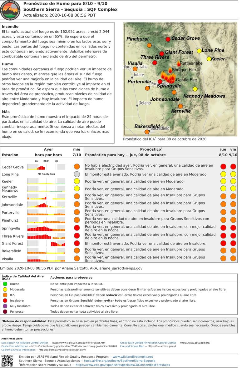
SQF Complex Daily Update for Oct 8
Related Incident:
Publication Type: News
Incident Information:
Start / Report Date: 8/19/20
Cause: Lightning
Resources:
Hand Crews: 18
Dozers: 21
Size: 162,952 acres
Location: 25 miles N of Kernville, CA
Helicopters: 8
Water Tenders: 11
Containment: 65 %
Injuries: 17
Structures Destroyed: 228
Engines: 51
Total Personnel: 749
Current Situation:
The uncontained fire’s edge to the north continues to burn actively. Heavy vegetation, snags, and steep terrain make it difficult to access the fires edge. Threats to infrastructure on Case Mountain, the Hockett Ranger Station, Peck’s Cabin, Buffalo Cabin, several sequoia groves and wilderness values within Sequoia National Park continue. Hockett Meadow ranger station and other structures in South Fork are being prepped for fire protection wrap. Crews are working to stop the fire from spreading and will focus on securing the perimeter and building contingency line along Mineral King Road to Case Mountain.
As the temperatures start to cool and the smoke begins to clear, fire activity is expected to increase. The potential for smoke columns starting to form near Homers Nose may be seen in the South Fork and Three Rivers areas. With clear visibility, there will be an increased use of aircraft and helicopters to focus on dropping water and fire retardant in the areas most at risk.
Tulare County Sheriff’s Office has issued an evacuation order on October 6 for everything south of the intersection of the Cinnamon Canyon Road and South Fork Drive, including Cinnamon Canyon. South Fork Drive needs to remain available for fire crews and heavy equipment access from Highway 198 to Cinnamon Canyon Road. Please drive with caution.
Camp Nelson, Pierpoint, Ponderosa, Coy Flat, Doyle Springs, Rogers Camp, and Mountain Aire are under an Evacuation Warning. Mountain Home Camp, South Fork Drive Area, Alpine Village, Cedar Slope, Pyles Boys Camp, Redwood Drive, and Sequoia Crest are under an evacuation order. For more information visit: https://tularecounty.ca.gov/recovers/.
The southern perimeter is holding. Crews will focus on removing fire weakened trees and hot spots in this area. Preparing the communities of Sequoia Crest and Cedar Slope for people to return to these areas remains a high for fire crews. There are sections that are unburnt and may burn causing an increase of visible smoke from inside the perimeter. Crews and aircraft will continue to monitor these areas.
Tulare County has opened a Local Assistance Center (LAC) at the Government Plaza (1055 West Henderson Avenue, Porterville, CA). Hours are 8:00 am to 5:00 pm, Monday through Friday, and 9:00 am to 3:00 pm on Saturday and Sunday. A satellite LAC is open in Camp Nelson on Tuesdays and Thursdays, 10:00 am 4:00 pm.
For the communities of Cedar Slope, Alpine Village, Sequoia Crest, and Redwood Drive Tulare County Officials will allow for short term visits by owners, enabling them to survey damage and salvage items. Cedar Slope residents will have access on Saturday, October 10 from 10:00 am to 2:00 pm. Alpine Village, Sequoia Crest and Redwood Drive will have access Sunday, October 11 from 10:00 am to 2:00 pm. Check in will take place at the Local Assistance Center (LAC) at 1055 W. Henderson in Porterville starting at 8:00 am. After checking in and verification of information, property owners can then proceed to Camp Nelson Fire Station where they will be escorted into their community. Everyone will be escorted out of the area at 2 pm. Only property owners on the designated day will be granted temporary access to their properties, in their respective community. Only one vehicle per property will be allowed. For more information visit: www.TulareCounty.ca.gov/
As residents return to the areas that have been opened, it is extremely important that they continue remain clear of all closure areas. Activities, such as wood gathering and hunting are not allowed within the forest closure. For more information visit: https://www.readyforwildfire.org/post-wildfire/returning-home/.
We appreciate the outpouring of gratitude from the public and community organizations for our firefighters, including CONAFOR Fire Crews from Mexico and the United States. For those who would like the opportunity to thank our firefighters, you can tag us on Facebook at @sequoiaforest or send cards to: Sequoia National Forest Headquarters, ATTN: SQF Complex Firefighters, 1839 South Newcomb Street Porterville, CA 93257. Please note we are only accepting cards and thank you for your support.
Evacuations:
- Evacuation Orders, Map and Warnings for Tulare County.
- Tulare County has a structure assessment form for evacuees affected by the fire to provide contact information for County officials as the damage assessment continues. An interactive map showing damaged structures is available.
- Tulare County Health & Human Services Agency hotline for affected citizens – (559) 802-9790
- The Red Cross has evacuation centers at Porterville Community College and the North Exeter Community Building. Also, call the Red Cross at 1-800-RED-CROSS.
Closures:
- Sequoia National Forest closure of area north of Tulare/Kern county line: Forest Order 0513-20-34 SQF Western Divide and Kern River Ranger Districts Complex Fire Area, Trail, and Road Closure
- Regional Emergency Fire Restrictions are in place: Regional Order No. 20-18
- The Bureau of Land Management Bakersfield Office has issued a temporary emergency closure.
- Road closures due to the SQF Complex may be found by clicking here.
- The Temporary Flight Restriction (9/19/20) may be found here. Drones are prohibited.
- Sequoia and Kings Canyon National Park are open except for a large portion of the wilderness in Sequoia National Park due to wildfire. For more information please visit www.nps.gov/seki
Smoke: Current air quality may be found at https://fire.airnow.gov/
Alert: To receive emergency notifications regarding evacuations and critical events sign up at alerttc.com
Cooperating and Assisting Organizations: Southern California Edison, Tulare County Fire, Tulare County Sheriff, Tulare County OES, Tulare County Roads, California Highway Patrol, California Department of Corrections and Rehabilitation, California Conservation Corps, California Office of Emergency Services, AT&T, Verizon, California Department of Transportation, California Air National Guard, and California National Guard. CONAFOR, Mexico.
Safety Message: Prepare for the possibility of fire in their area in advance, visit www.ready.gov/wildfires.
SQF Complex Daily Update for Oct 7
Related Incident:
Publication Type: News
Incident Information:
Start / Report Date: 8/19/20
Cause: Lightning
Resources:
Hand Crews: 21
Dozers: 8
Size: 160,908 acres
Location: 25 miles N of Kernville, CA
Helicopters: 8
Water Tenders: 17
Containment: 65 %
Injuries: 17
Structures Destroyed: 228
Engines: 51
Total Personnel: 853
Current Situation:
The fire is active in the northwest area near Cedar and Squaw Creek and has spread to Homers Nose moving east toward the Hockett Meadow area. Threats to infrastructure on Case Mountain, the Hockett Ranger Station, several sequoia groves and wilderness values with Sequoia National Park continue. Hockett Meadow ranger station and structures in South Fork are being prepped to be wrapped in fire protection wrap. Crews are working to stop the fire from spreading and will focus on securing the perimeter and building contingency line along Mineral King Road to Case Mountain.
As the temperatures start to cool and the smoke begins to clear, fire activity is expected to increase. The potential for smoke columns starting to form near Homers Nose may be seen in the South Fork and Three Rivers areas. With clear visibility, there will be an increased use of aircraft and helicopters to focus on dropping water and fire retardant in the areas most at risk.
Tulare County Sherriff’s Office has issued an evacuation order on October 6 for everything south of the intersection of the Cinnamon Canyon Road and South Fork Drive, including Cinnamon Canyon. South Fork Drive needs to remain available for fire crews and heavy equipment access from Highway 198 to Cinnamon Canyon Road.
Camp Nelson, Pierpoint, Ponderosa, Coy Flat, Doyle Springs, Rogers Camp, and Mountain Aire are under an Evacuation Warning. Mountain Home Camp, South Fork Drive Area, Alpine Village, Cedar Slope, Pyles Boys Camp, Redwood Drive, and Sequoia Crest are under an evacuation order. For more information visit: https://tularecounty.ca.gov/recovers/.
The southern perimeter is holding. Crews will focus on removing fire weakened trees and extinguish hot spots in this area. Preparing the communities of Sequoia Crest and Cedar Slope for people to return to these areas remains a high priority for fire crews. There are sections that are unburnt and may burn causing an increase of
visible smoke from inside the perimeter. Crews and aircraft will continue to monitor these areas.
Tulare County has opened a Local Assistance Center (LAC) at the Government Plaza (1055 West Henderson Avenue, Porterville, CA). Hours are 8:00 am to 5:00 pm, Monday through Friday, and 9:00 am to 3:00 pm on Saturday and Sunday. A satellite LAC is open in Camp Nelson on Tuesdays and Thursdays, 10:00 am 4:00 pm.
As residents return to the areas that have been opened, it is extremely important that they continue remain clear of all closure areas. Activities, such as wood gathering and hunting are not allowed within the forest closure. These areas will reopen as soon as it is reasonably safe to do so. For more information visit: https://www.readyforwildfire.org/post-wildfire/returning-home/.
There has been a transfer of command from California Incident Management Team 2 to Southern California Incident Management Team 13 on October 6, 2020 at 6:00 pm.
Evacuations: · Evacuation Orders, Map and Warnings for Tulare County. · Tulare County has a structure assessment form for evacuees affected by the fire to provide contact information for County officials as the damage assessment continues. · An interactive map showing damaged structures is available.
· Tulare County Health & Human Services Agency hotline for affected citizens – (559) 802-9790 · The Red Cross has evacuation centers at Porterville Community College and the North Exeter Community Building. Also, call the Red Cross at 1-800-RED-CROSS.
Closures: · Sequoia National Forest closure of area north of Tulare/Kern county line: Forest Order 0513-20-34 SQF Western Divide and Kern River Ranger Districts Complex Fire Area, Trail, and Road Closure · Regional Emergency Fire Restrictions are in place: Regional Order No. 20-18 · The Bureau of Land Management Bakersfield Office has issued a temporary emergency closure. · Road closures due to the SQF Complex may be found by clicking here. · The Temporary Flight Restriction (9/19/20) may be found here. Drones over the fire area are prohibited.
· Sequoia and Kings Canyon National Park are open except for a large portion of the wilderness in Sequoia National Park due to wildfire. For more information please visit www.nps.gov/seki
Smoke: Current air quality may be found at https://fire.airnow.gov/ Alert: To receive emergency notifications regarding evacuations and critical events sign up at alerttc.com
Cooperating and Assisting Organizations: Southern California Edison, Tulare County Fire, Tulare County Sheriff, Tulare County OES, Tulare County Roads, California Highway Patrol, California Department of Corrections and Rehabilitation, California Conservation Corps, California Office of Emergency Services, AT&T, Verizon, California Department of Transportation, California Air National Guard, and California National Guard. CONAFOR, Mexico.
Safety Message: Residents in the affected areas are encouraged to continue to prepare for the possibility of fire in their area in advance. Go to www.ready.gov/wildfires to learn how to prepare.
Actualizacin de incidente del Complejo SQF Fecha 1062020
Related Incident:
Publication Type: News
Situación actual:
El incendio estuvo activo anoche en el área de Mountain Home, al suroeste de Dennison Mountain. Los bomberos se ocuparon de controlar directamente el fuego y hoy limpiarán el área. El incendio también estuvo activo en el área de South Fork Campground, donde cruzó la bifurcación sur del río Kaweah y está ardiendo hacia Homers Nose quemando materiales combustibles caídos y pesados.
El incendio de Shotgun está completamente controlado.
Hoy, a medida de que cambie el clima, se espera que el aire sobre el incendio se aclare. Esto permitirá que los aviones vuelen sobre el área para ver bien la posición actual del incendio. El cielo despejado también traerá un comportamiento de fuego más activo. Durante los últimos días, un sistema de alta presión ha mantenido una capa espesa de humo sobre el incendio. Esto es como tener una tapa sobre una olla en la cocina. Una vez que se quita, el calor aumenta y el oxígeno alimenta el fuego. Esta es la prioridad estratégica más importante del incendio y el personal y los aviones se concentrarán en el área durante los próximos días.
Se está construyendo una línea de control principal en la bifurcación sur del río Kaweah que se conectará con el borde del incendio cerca de South Fork Campground. Además, las cuadrillas y las excavadoras están construyendo una línea de contingencia a lo largo de Case Mountain.
Los bomberos también se centrarán en la eliminación de varios árboles de gran peligro en el área de Sequoia Crest. Se contrataron equipo y personal especiales para abordar este problema. Hay muchos árboles peligrosos en toda la zona del incendio. Por un tiempo, se podrá observar en el área humo de los árboles e islas de vegetación que aún no se han quemado. Los focos de fuego cerca de la línea se extinguirán una vez que los bomberos logren ubicarlos. Es posible que se permita que se quemen otras zonas de fuego que no representen una amenaza para la línea, mientras las cuadrillas de bombero se concentran en las prioridades más importantes.
El condado de Tulare abrió un Centro de Asistencia Local (Local Assistance Center, LAC) en Government Plaza (1055 West Henderson Avenue, Porterville, CA). El horario de atención es de 8:00 a. m. a 5:00 p. m., de lunes a viernes, y de 9:00 a. m. a 3:00 p. m. los sábados y domingos. Se abrirá un LAC satélite en Camp Nelson los martes y jueves de 10:00 a. m. a 4:00 p. m.
Camp Nelson, Pierpoint, Ponderosa, Coy Flat y Doyle Springs se encuentran bajo advertencia de evacuación. Para obtener más información, visite https://tularecounty.ca.gov/recovers/.
A medida que los resistentes retornen a las áreas abiertas, es sumamente importante que sigan manteniéndose lejos de las áreas cerradas. Las actividades, como la recolección de madera y la caza, no están permitidas dentro del cierre del bosque. Estas áreas volverán a abrir tan pronto como sea razonablemente seguro hacerlo. Para obtener más información, visite: https://www.readyforwildfire.org/post-wildfire/returning-home/.
Se espera que las temperaturas bajen durante los próximos 3 a 5 días, cuando el sistema de alta presión en el área comience a debilitarse. Se espera que las temperaturas estén 10 grados por debajo de lo normal. A pesar de las temperaturas en descenso, se espera que permanezca seco con niveles de humedad muy bajos. La humedad en la vegetación viva y muerta se encuentra en el nivel más bajo registrado.
Evacuaciones:
Órdenes de evacuación, mapa y advertencias para el condado de Tulare.
El condado de Tulare cuenta con un formulario de evaluación de estructuras para que los evacuados afectados por el incendio proporcionen información de contacto a los funcionarios del condado mientras continúa la evaluación de daños.
Un mapa interactivo que muestra las estructuras dañadas está ahora disponible.
Línea directa de la Agencia de Salud y Servicios Humanos del condado de Tulare para ciudadanos afectados – (559) 802-9790
La Cruz Roja tiene centros de evacuación en Porterville Community College y en North Exeter Community Building. También puede llamar a la Cruz Roja al 1-800-RED-CROSS.
Cierres:
Sequoia National Forest está cerrado al norte de la línea del condado de Tulare/Kern: Orden forestal 0513- 20-34 Cierre del área de incendio, senderos y caminos de los distritos de guardabosques de Western Divide y Kern River del complejo SQF
Existen restricciones regionales de emergencia contra incendios: Orden Regional núm. 20-18
La Oficina de Administración de Tierras de Bakersfield ha emitido un cierre de emergencia temporal.
Consulte los cierres de carreteras debido al Complejo SQF haciendo clic aquí.
Consulte la restricción temporal de vuelos (9/19/20) aquí. Los drones sobre el área del fuego están prohibidos.
Los Parques Nacionales Sequoia y Kings Canyon están abiertos a excepción de una gran parte de la naturaleza en el Parque Nacional Sequoia debido a los incendios forestales. Para mayor información por favor visite www.nps.gov/seki
Humo: La calidad actual del aire se puede encontrar en https://fire.airnow.gov/
Alerta: Para recibir notificaciones de emergencia sobre evacuaciones y eventos críticos, regístrese en alerttc.com
Organizaciones de colaboración y asistencia: Southern California Edison, Bomberos del Condado de Tulare, Sheriff del Condado de Tulare, Oficina de Servicios de Emergencia (Office of Emergency Services, OES) del Condado de Tulare, Carreteras del Condado de Tulare, Patrulla de Caminos de California, Departamento Correccional y de Rehabilitación de California, Cuerpo de Conservación de California, Oficina de Servicios de Emergencia de California, AT&T, Verizon, Departamento de Transporte de California, Guardia Nacional Aérea de California y Guardia Nacional de California. CONAFOR, México.
Mensaje de seguridad: Se recomienda a los residentes en las áreas afectadas que continúen con los preparativos anticipados ante un posible incendio en su área. Visite www.ready.gov/wildfires para obtener información acerca de cómo prepararse.
Southern Sierra Sequoia SQF Complex Pronstico de Humo para 610 71
Related Incident:
Publication Type: News
Actualizado: 2020-10-06 09:20 PDT
Incéndio
El tamaño actual del fuego es de 158,945 acres, creció 887 acres, y está contenido en un 65%. Se espera que el comportamiento del fuego sea mínimo en los lados este, sur y oeste. Las partes del fuego no contenidas en el lado norte continúan ardiendo activamente. Bolsillos interiores de combustible continúan ardiendo dentro del perímetro.
Humo
El humo tiene la posibilidad de persistir en las comunidades cercanas al fuego. El humo en otras partes de la region también contribuye al impacto en el área de pronóstico. Las comunidades cerca del drenaje del rio Kern podrían ver una mejor calidad de aire en la tarde, a medida que vientos leves del sureste aumenten un poco en velocidad. El impacto de humo dependerá grandemente de la actividad de fuego.
Más
Este pronóstico de humo muestra el impacto de 24 horas de partículas en la calidad de aire. La calidad de aire puede cambiar inesperadamente. Si comienza a notar efectos del humo en su salud, se le recomienda que vea los enlaces mas abajo.
Southern Sierra Sequoia SQF Complex Smoke Outlook for Oct 6 and 7
Related Incident:
Publication Type: News
Issued at: 2020-10-06 08:23 PDT
Fire
Current fire size is 158,945 acres with a growth of 887 acres and containment is 65%. The fire behavior on the East, South and West sides are expected to be minimal. The uncontained fire's edge to the North continues to burn actively. Interior pockets of fuel continue to burn throughout the perimeter.
Smoke
Smoke has the potential to linger in communities that are in close proximity to the fire. Regional smoke may also be contributing to smoke impacts in the forecast area. Communities near the Kern River may see better air quality in late afternoon as Southeast winds slightly pick up. Smoke impacts will be heavily dependent on fire activity.
Special Notes
Smoke Outlook reflects 24 hour particulate matter impacts on air quality. Air quality may change unexpectedly.