
Update to the Deschutes National Forest Closure Order October 3 2020
Related Incident:
Publication Type: Closures
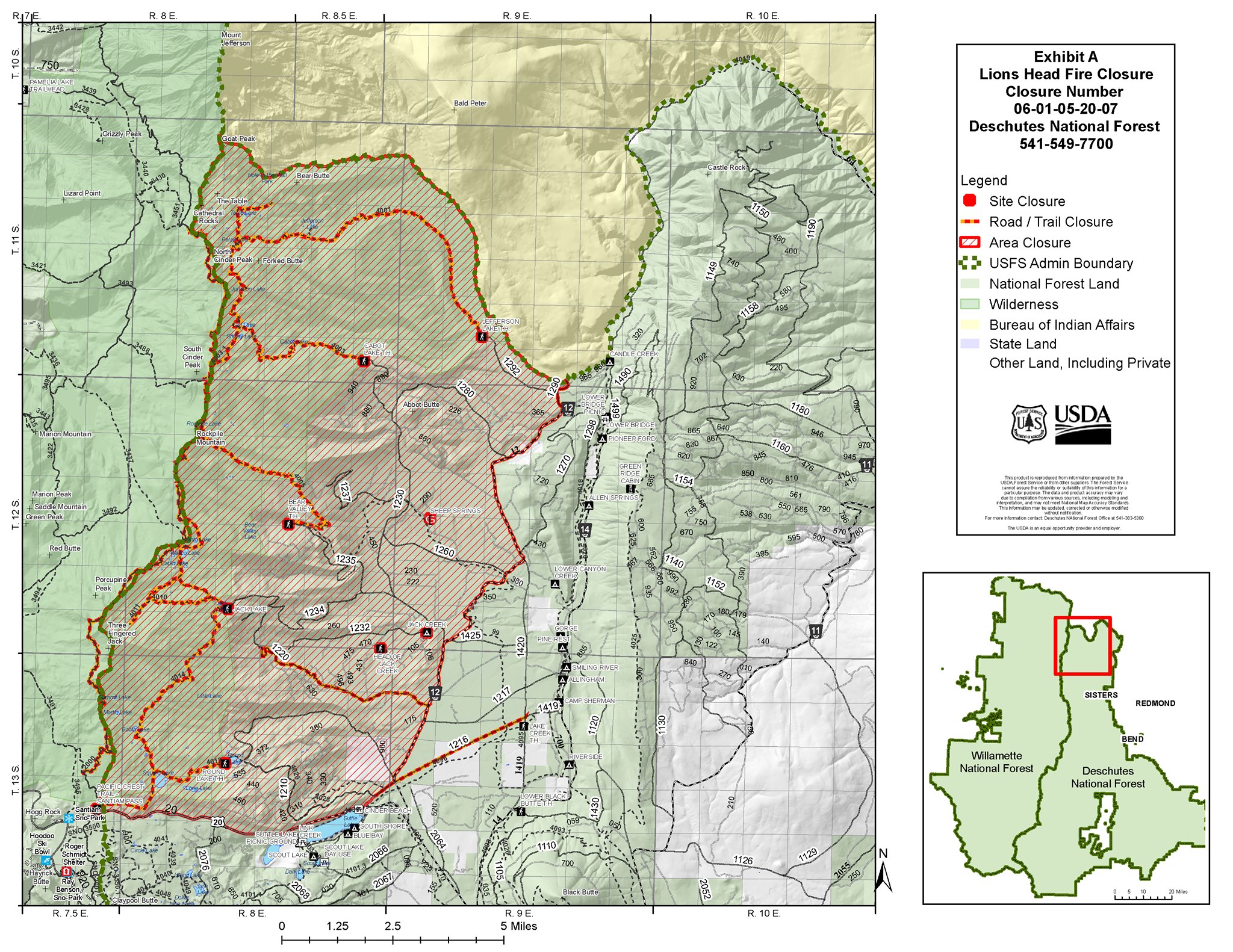
The Pacific Crest Trail (PCT) (Pacific Crest Trail Association) has reopened from the Deschutes National Forest’s southern border at Windigo Pass north to Santiam Pass. The PCT remains closed north of Santiam Pass due to Lionshead Fire Closure as fire suppression is still occurring in this area.
Lionshead Fire Update October 3 2020
Related Incident:
Publication Type: News
Lionshead Fire update for Saturday, Oct. 3
REDMOND, Ore. – Firefighters’ energy and morale are high all around the 328-mile perimeter of the Lionshead Fire, fire managers reported Friday.
“We are in a good rhythm,” said John Spencer, operations chief trainee. “There’s a lot of work getting done.”
Friday, a considerable amount of black line was completed around the southwest corner of the fire, with only a section to the north of Marion Forks not yet fully contained. Work will continue today to reinforce those lines and crews expect to finish work in the Stahlman Cabins area in the next day or two.
Fallers cleared an additional two miles of Hwy. 46; and assessment began of the damaged powerline system on the Warm Springs reservation. To the northwest, a spot fire was contained in the “finger,” and crews continue to identify and extinguish hot spots.
In the interior, the fire continues to burn actively. To the northeast, previously unburned fuel pockets within the interior are being consumed, with occasional single tree burning, called torching. Although fire progression is slow, there is still a significant amount of fuel available to burn. Needle cast and leaf fall are adding new fuels to burned and unburned areas across the fire footprint as well.
Aviation is still providing water support on the southwest corner and also coordinated a flight to assess Oregon Department of Forestry-protected timberlands.
Winds will be out of the northwest at 10 mph today and 15 mph Sunday, with gusts up to 23 mph. This could stimulate active burning in other areas of the fire, but significantly increases the risk to firefighters in another way falling trees are a leading cause of death in hazard areas. At times, crews may have to stop work and seek shelter.
Weather: High temperatures will be around 80 today, drop to 70 Sunday, then settle into the mid-70s Monday-Wednesday.
Evacuations and Closures: Breitenbush Hot Springs remains at Level 3 – “Go!” Detroit, Idanha, Hwy. 22 east of Detroit Dam to milepost 56, and Opal Creek Wilderness/Jawbone Flats are at Level 2 – “Be Set.” Elkhorn, Gates east of Gates Hill Road, and Hwy. 22 from Gates Hill Road east to Detroit Dam are at Level 1 – “Ready.” Residents of Linn County can find up to date information at www.LinnSheriff.org. Closure orders and maps can be found at https://inciweb.nwcg.gov/incident/7049/
Other information: Campfire and personal woodcutting are allowed on the Willamette National Forest. Chainsaw use is not allowed from 1 p.m. to 8 p.m., and must be followed by a one-hour fire watch after equipment is shutdown. A list of forest recreation areas within the fire zone that remain closed can be found at https://go.usa.gov/xGpeV
Confederated Tribes of Warm Springs assemble fish barrels
Related Incident:
Publication Type: News
Employees of the Confederated Tribes of Warm Springs assemble fish barrels to prevent pumps drawing water from Jefferson Creek during fire suppression activities from also pulling in fish, particularly Bull trout, which are classified as a threatened species under the Endangered Species Act in Oregon. Bull trout were once found in about 60 percent of the Columbia River Basin, but today, they occur in less than half of their historic range.
For more information, visit:
https://warmsprings-nsn.gov/program/fisheries-department
https://www.fws.gov/pacific/bulltrout/About.html


Lionshead Fire Hunting Update
Related Incident:
Publication Type: News
Hunting in Fire Area In addition to residents and businesses, wildfires impact recreation and hunting, continuing into suppression and recovery efforts, which could take weeks or months, potentially long into the future. Local and visiting populations are affected, which include short and long-term effects on the land, indirect effects of fire operations, fuel treatments, area closures, and other disruptions to the public. Unfortunately, there can be substantial impacts of fire on outdoor recreation now and into the future.
Please use caution and keep the following in mind as areas open for hunting and recreating in an area recently burned by wildfire:• People intending to hike into, or near, the fire area should remain alert and aware of their surroundings at all times.
• Know the forecasted weather before entering the area, assess the weather conditions while in the area, and stay clear of burned trees. Don’t camp or hang out in the wildfire area.
• Hazard trees or snags tend to pose the most imminent threat. Dead or dying trees that remain standing after a wildfire are unstable, especially in high winds.
• People are more likely to be aware of obstacles on the ground but don’t often look up to assess danger. “Look up, look down, look around”
• Forest visitors can expect to encounter firefighter traffic, dusty roads, areas of smoke.
• Other hazards to be aware of include:
Burned-out stump holes can make the ground weak and subject to failure
Loose rocks and logs are unpredictable and present the hazard of rolling debris.
Ash and fallen needles are slippery and can make for treacherous footing on trails.
Flash floods and mud flows may occur, especially in areas without vegetation.
Due to the immediate and long-term risks to both the public and the land, closures often remain in place long after containment is reached. This keeps the public safe and gives the land a chance to heal. All decisions on road and area closures are made by the local agencies that manage the roads and lands.
In this case, the Forest Service will decide when it is safe to update the area closures in the #LionsheadFire area. They will coordinate with fire mangers, Division of Wildlife, other state agencies, and local jurisdictions to determine this change. As always, safety of the public and our firefighters is the greatest factor in these decisions.
Lionshead Fire Update Friday October 2 2020
Related Incident:
Publication Type: News
Lionshead Fire update for Friday, Oct. 2
REDMOND, Ore. – Active suppression work is continuing on the southwest corner of the fire and around the finger to the north, while patrolling, chipping and backhauling – the gathering up of miles of hose and other tools used to combat the fire – is taking place along large sections of the fire perimeter.
In other work, the roads group cleared a mile or more of the Hwy. 46 corridor Thursday and will continue work today.
Aviation continued to coordinate non-fire flights for fire-related purposes, including a survey of Rocky Mountain goats on Mt. Hood. The Civil Air Patrol finished grid mapping for the Federal Emergency Management Agency.
A previously inactive spot fire located about 10 miles northwest of Breitenbush Hot Springs, within the 2011 Motherlode Fire burn scar, flared up in recent days and has spread to 25 acres. Helicopters dropped water Wednesday and Thursday to slow its progression. Lionshead and Beachie Creek fire managers are monitoring the situation closely and have established a series of trigger points for escalating the response if needed.
Yesterday, Oregon Department of Transportation added an additional pilot car to the Santiam Canyon schedule. The new pilot car schedule for Hwy. 22 is: Detroit to Gates at 7:30 a.m.; Gates to Detroit at 9 a.m.; Detroit to Gates at 11 a.m.; Gates to Detroit at 1 p.m.; Detroit to Gates at 5 p.m.; and Gates to Detroit at 6 p.m.
The road block on Hwy. 22 has been moved to milepoint 46.7 to open access to bathroom and other facilities at Mongold State Park. This area will be used to stage vehicles waiting for the pilot car.
Today, the Willamette National Forest lifted public restrictions on campfires due to increased moisture and cooler temperatures. Personal firewood cutting may resume, but chainsaw use is not allowed from 1 p.m. to 8 p.m., and must be followed by a one-hour fire watch after equipment is shutdown. The Sept. 25 closure order is still in effect. A list of recreation areas within the fire zone that remain closed can be found at https://go.usa.gov/xGpeV
Weather & Fuel Conditions: Most of Thursday’s smoke haze was from the California fires, although there was active burning deep within the perimeter of the northeast corner again. Temperatures will drop slightly today, into the high 70s to low 80s, with light winds continuing.
Evacuations and Closures: Breitenbush Hot Springs remains at Level 3 – “Go!” Detroit, Idanha, Hwy. 22 east of Detroit Dam to milepost 56, and Opal Creek Wilderness/Jawbone Flats are at Level 2 – “Be Set.” Elkhorn, Gates east of Gates Hill Road, and Hwy. 22 from Gates Hill Road east to Detroit Dam are at Level 1 – “Ready.”
Residents of Linn County can find up to date information at www.LinnSheriff.org. All closures on federal lands remain in effect. This includes a 40-mile section of the Pacific Crest Trail between Santiam Pass and Olallie Lake. Closure orders and maps can be found at https://inciweb.nwcg.gov/incident/7049/
Updated Willamette National Forest Closure Order
Related Incident:
Publication Type: Closures
Day use areas, trails, trailheads, boat ramps and more located OUTSIDE OF THE FIRE CLOSURE AREA have reopened as of September 25, 2020. Hoo Doo remains closed as it is currently being used as a fire camp. Additionally, all campgrounds remain closed. For awareness, not all trails have been surveyed and cleared since the windstorm, so there is likely to be trees and debris across the trails.
Recreation sites INSIDE OF THE FIRE CLOSURE AREA that remain closed as of September 25, 2020
Middle Fork Ranger District
• All campgrounds
• Fall Creek Road and all adjacent sites
McKenzie River Ranger District
• All campgrounds
• Road 19 between Hwy 126 and Road 1980
• Terwilliger Hot Springs
• French Pete Trailhead
• Echo Boat Launch
• Bruckart Boat Launch
• Saddle Dam Boat Launch
• O’Leary/Castle Rock Trailhead
• Kings Castle Trailhead
• Olallie North Trailhead
• Lower section of the McKenzie River Trail (where it crosses Rd 2654 – Deer Creek Road to the southern terminus) and associated trailheads
• Frissell Boat Launch
• Paradise Boat Launch
• Big Lake Road, Ray Benson Sno-Park, and portions of the Santiam Pass OHV Area
• Pacific Crest Trail – Santiam Pass Trailhead
• Pacific Crest Trail north of Highway 20
Sweet Home Ranger District
• All campgrounds
• Hackleman Old Growth Trailhead
• Santiam Wagon Road, from west from the junction with Rd 2672
• Iron Mountain – Deer Creek Trailhead (Iron Mountain – Civil Road TH remains open)
• House Rock Day Use Area
• Gordon Lakes Trailheads (all three)
Detroit Ranger District
• All campgrounds
• All recreation sites
• All wilderness areas (Opal Creek and Mt. Jefferson)
• All trails • Pacific Crest Trail north of Highway 20
Lionshead Fire Update Thursday October 1 2020
Related Incident:
Publication Type: News
Lionshead Fire update for Thursday, Oct. 1
REDMOND, Ore. – A considerable amount of smoke was visible around the northeast corner of the fire yesterday as warmer temperatures dried out fuels, leading to more active burning of the interior.
“There are green islands within the established fire perimeter, with abundant dry fuels,” fire behavior analyst Dean Warner said. “We can expect to see this type of activity west across to the Cascade Crest in the coming days.”
All burning took place at least a thousand feet in from the perimeter and there was no risk of the fire escaping containment.
Wednesday afternoon, Marion County Sheriff’s Office modified evacuation levels in several areas. Breitenbush Hot Springs remains at Level 3 – “Go!” Detroit, Idanha, Hwy. 22 east of Detroit Dam to milepost 56, and Opal Creek Wilderness/Jawbone Flats are at Level 2 – “Be Set.” Elkhorn, Gates east of Gates Hill Road, and Hwy. 22 from Gates Hill Road east to Detroit Dam are at Level 1 – “Ready.”
Crews continue to complete direct and indirect line around the southwest corner, as well as mopping up a number of hot spots. Hot spots are small pockets of coals or smoldering logs or stumps that are identified by smoke, placing a hand near it, or – in some cases through infrared mapping of an area.
In addition to bucket work to aid suppression work around the west/southwest boundary, aviation will coordinate a powerline reconnaissance flight with Pacific Gas and Electric as well as ongoing Civil Air Patrol flights.
All around the 328-mile fire boundary, chipping, removal of heavy equipment and suppression repair work are ongoing. On the interior, the structural group at Stahlman Cabins is also removing equipment and beginning repair.
Approximately 200 Canadian fire personnel will finish their assignment to the Lionshead Fire in the coming days. They worked with their American counterparts at every level, from hand crews cutting line to incident command staff. Pacific Northwest Team 13 would like to thank them for their invaluable assistance.
Weather & Fuel Conditions: Temperatures today will be slightly higher, reaching the low to mid 80s below 5,000 feet in elevation. This weekend is expected to be slightly cooler, as a west wind moves in, bringing cool, moist air with it.
Safety: Oregon's largest hunting season begins Saturday, Oct. 3, with general season hunting in Western Oregon and controlled deer hunting in Eastern Oregon. This may result in increased traffic in some areas, as area closures have reduced available hunting options.
Closures and Evacuations: Residents of Linn County can find up to date information at www.LinnSheriff.org. All closures on federal lands remain in effect. This includes a 40-mile section of the Pacific Crest Trail between Santiam Pass and Olallie Lake. Closure orders and maps can be found at https://inciweb.nwcg.gov/incident/7049/
Marion County Updates Pilot Car Schedule Between Gates and Detroit Oct 1
Related Incident:
Publication Type: Closures
For those traveling to and from the Detroit area please read the Marion County Sheriff and ODOT update to pilot car times and road block locations:
“New pilot car added to OR 22E schedule starting October 1, 2020:
Starting on Thursday, October 1, the Oregon Department of Transportation is adding a new pilot car to the schedule to allow residents to get back into the Santiam Canyon later in the day. The new pilot car will run at 6 p.m. from Gates to Detroit/Idanha. The new pilot car schedule is:
7:30 a.m. Detroit to Gates
9 a.m. Gates to Detroit
11 a.m. Detroit to Gates
1 p.m. Gates to Detroit
5 p.m. Detroit to Gates
6 p.m. Gates to Detroit
ODOT is also moving one of the road blocks from milepoint 50.5 to approximately 46.7 to allow for access into Mongold State Park for bathroom and other facilities starting at 7 p.m. on Thursday.
We will also be using the state park to stage those folks wanting to get into the pilot car line. ODOT continues to use pilot cars in the Santiam Canyon to safety move residents through numerous work zones where hazard trees are being removed. “

Suppression Repair on Lionshead Fire
Related Incident:
Publication Type: News
Suppression repair on a wildfire is completed to reduce the impacts that crews and equipment made during firefighting operations. These efforts reduce potential soil erosion and repair damage to infrastructure. On the #LionsheadFire, this repair of suppression efforts are already underway in areas where containment has been achieved.
Weather events, particularly rain, can cause surface soils to slide down hills, into gullies and streams. The potential for severe soil erosion is a consequence of wildfire because it burns and removes plant material, including root systems, and the litter layer, which naturally slows water movement. Different actions of suppression repair are underway on the fire.
Chipping debris and branches: Chipping the debris that was cut during line construction can spread out the piles of fuel created during line building operations. Once it is spread, it can minimize erosion by creating a layer of debris to help catch or slow water runoff (see photos below of Chipping near Detroit).
Water Bars: Crews create water bars along fire lines, which are a diagonal channel dug across the road that diverts surface water (that would otherwise flow down the whole length of the road) off the road and into a stable drain way. These are particularly useful on steep slopes that are more susceptible to soil erosion.Berms & Slash: Firelines, especially dozer lines, can create berms of soil and vegetation on the sides of where the dozer cleared. Crews are working to pull the berms back into place, spread them within the line, and then fill the lines with the slash (or cut brush and limbs). This helps prevent the fire lines from becoming new paths for water to flow and accumulate. The slash helps protect new grass and shrub growth that may follow with rains.
Crews continue to work hard to both suppress the rest of the Lionshead Fire and lessen its impact on the land long term.