
Lionshead Fire Update Wednesday September 30th 2020
Related Incident:
Publication Type: News
Lionshead Fire update for Wednesday, Sept. 30
REDMOND, Ore. – Work on the fire is progressing rapidly, with large sections of containment line nearing completion and other areas shifting to patrol and monitor status.
“It was warmer today and there was more smoke in the air, but things are holding and looking really good,” John Spencer, operations chief trainee, said Tuesday evening. “On the southwest corner, we’re going to see a lot more black line soon. Water support is really helping with that.”
Crews will continue building direct and indirect line in the Cooper’s Ridge area for the next several days. The structural group in Idanha shifted to patrol and mopup status Tuesday, the south central section of the fire will shift to patrol status today, and work has begun to rehabilitate line and remove heavy equipment around Stahlman cabins.
Fallers will begin cutting hazard trees along the Hwy. 46 corridor today, and heavy equipment is being brought in to speed up the process. Direct and indirect handline around Cooper’s Ridge to the south and the finger to the north should be completed in the next few days. Chipping of brush and hazard trees will continue at various points around the fire boundary for the next week to 10 days.
Fire managers have received suppression repair and mopup standards from the Confederated Tribes of Warm Springs and Forest Service and will use those to guide their work as the suppression effort draws to a close. These standards outline the type and extent of work to be done before the fire is returned to local control.
Depending on the terrain and fuels, completed containment lines can be a combination of dozer line, hand line, back burn or burnout, and measure 100 to 200 feet deep. Repair work consists of pushing surface material that was removed by hand or with heavy equipment back into place or position it to prevent erosion. Later, Burned Area Emergency Response will continue this work using a variety of means tailored to the many different areas and conditions within the burn zone.
Weather & Fuel Conditions: Temperatures will be in the high 70s to low 80s below 5,000 feet elevation with light upslope winds through Friday. Some smoke may visible in the interior of the fire as lighter fuels dry out and are consumed.
Closures and Evacuations: Evacuation levels around Detroit, Idanha, and the Elkhorn community along North Fork Road are at Level 2 – “Be Set.” Due to the remaining hazards in the cities of Detroit and Idanha, plus lack of basic services, non-residents should avoid travel in the area. Breitenbush Hot Springs remains at a Level 3 – “Go!” Marion County Sheriff’s Office continues to coordinate an enhanced presence around these communities. Residents of Linn County can find up to date information at www.LinnSheriff.org.
The Warm Springs Reservation is closed to non-tribal members. The general public should avoid crossing reservation boundaries to view fire damage or for any other purpose.
Lionshead Fire Update Tuesday September 29 2020
Related Incident:
Publication Type: News
Lionshead Fire update for Tuesday, Sept. 29
“We got a lot of good work done today and we’re seeing great progress,” John Spencer, operations chief trainee, reported Monday. “We should be moving a lot of area to patrol status in the next two or three days.”
Mop-up is extinguishing or removing burning material along or near a control line, felling snags, or moving logs so they won't roll downhill. Cold trailing is when firefighters feel the edge of a burning area with the hand and dig out or trench around burning spots.
Today, a roads group will begin removing hazard trees along the 46 corridor between Detroit and Breitenbush. Fire managers are still developing a hazard removal strategy for Hwy. 22 to ensure safe public access. On the southwest corner, crews are reinforcing line and linking segments of containment line in the Cooper’s Ridge area.
Aviation was able to provide full support Monday, including water drops, Burned Area Emergency Response (BAER) and Resource Advisor (READ) reconnaissance, as well as coordinating with other aviation needs, including Civil Air Patrol flights for FEMA assessments.
Coordinating continues with fire managers on the Riverside Fire to establish contingency lines to the north and along the power line corridor. Crews are chipping around the “finger” on the west/northwest side of the fire as well as along the eastern and southeastern flanks.
Weather & Fuel Conditions: Temperatures will rise into the high 70s and low 80s at elevations below 5,000 feet today, which will begin drying out fuels that received less moisture during the recent rains. A shift in wind direction should push any active fire upslope and toward the interior.
Safety: Oregon is experiencing an increase in cases of COVID-19. Emergency responders and residents can protect themselves and others by socially distancing, wearing masks, washing hands and using hand sanitizer.
Closures and Evacuations: Evacuation levels around Detroit, Idanha, and the Elkhorn community along North Fork Road are at Level 2 – “Be Set.” Due to the remaining hazards in the cities of Detroit and Idanha, plus lack of basic services, non-residents should avoid travel to this area. Marion County Sheriff’s Office continues to coordinate with other law enforcement agencies to maintain an enhanced presence in the Detroit and Idanha areas as residents return to the area. Residents of Linn County can find up to date information at www.LinnSheriff.org.
The Warm Springs Reservation is closed to non-tribal members. The general public should avoid crossing reservation boundaries to view fire damage or for any other purpose.
Lionshead Fire Update Monday September 28 2020
Related Incident:
Publication Type: News
Lionshead Fire update for Monday, Sept. 28
Structural protection crews have shifted to patrol and chipping operations in Detroit and Idanha, as well as gathering the miles of hose used during the suppression effort.
Today, wind speeds of 20-25 miles per hour are expected, with gusts of 30 to 35. This will increase fire activity, primarily consuming fuels in the interior, particularly in open areas. Crews are strategically positioned to address flareups and spot fires.
Fire managers are developing hazard tree removal plans for Hwy. 22 to ensure safe public access, and for the 46 corridor to provide crews safe entry for mopup. On the southwest corner of the fire, crews have removed hazard trees in the Stahlman Cabin area. The eastern boundary of the fire is now in patrol status, with crews focusing on line rehabilitation and chipping. Aviation was able to provide water support with a sky crane Sunday and will continue doing so today.
Fire managers are coordinating with their counterparts on the Riverside Fire to establish contingency lines to the north and along the power line corridor. Firefighters expect to complete more line along the southern boundary in the coming days and begin mop up work in those areas.
Weather & Fuel Conditions: Temperatures will rise into the low 80s Tuesday, with lighter winds changing from the east/southeast to a more southeastern alignment.
Closures and Evacuations: Evacuation levels around Detroit, Idanha, and the Elkhorn community along North Fork Road are at Level 2 – “Be Set.” Due to the remaining hazards in the cities of Detroit and Idanha, plus lack of basic services, non-residents should avoid travel to this area. Marion County Sheriff’s Office continues to coordinate with other law enforcement agencies to maintain an enhanced presence in the Detroit and Idanha areas as residents return to the area.
Community members who reside in Linn County may find up to date information at www.LinnSheriff.org. There are no longer any evacuation notices for the Sidwalter/Miller Flats area in Jefferson County.
Roads and trails near the fire remain closed for public safety. The 12 Road and the 46 Road will remain closed to the public for the near future. This includes roads and trails on the Confederated Tribes of Warm Spring lands adjacent to the fire and the Pacific Crest Trail in the Deschutes National Forest. The Willamette National Forest, Bureau of Land Management, and State lands around the fire remain closed to the public. More information about closures can be found on the Lionshead Fire page at InciWeb.gov
Out of the Ashes at Lionshead Fire
Related Incident:
Publication Type: News
The
Daily Update for Lionshead Fire Sunday September 27
Related Incident:
Publication Type: News
Lionshead Fire Update – Sunday, September 27, 2020 - 10 a.m.
Firefighters Anticipate Warming and Drying Weather
Special Notice: This will be the last update prepared by the Rocky Mountain Area Type 1 Incident Management Team. Pacific Northwest Incident Management Team 13 will assume command of the fire this evening at 8 p.m.
Current Situation: Work on the Lionshead fire is proceeding well. Overnight, there was good moisture recovery, but the cool wet weather of the past few days is expected to be replaced today by a warming and drying trend. Shifting winds are also possible. This could result in a slight increase in fire behavior. Winds will likely be out of the east. The changing wind direction could test control lines in some new places. With the drying trend, there could be some fire movement, but a more likely scenario is for most fire activity to continue primarily in green, interior islands.
Firefighting Efforts by Division: (Refer to the map for division breakdown.)
Very little movement has occurred on the north edge of the fire in Division A over the past few days. As weather allows, firefighters will continue their work to secure the fire's edge and reinforce the contingency line to the north. Firefighters will be watching for deep burning stumps and underground holes during mop up operations.
Division E, G, K, and south to N, firefighters are working on mopping up hot spots along the fire line and doing more chipping.
The fire is still hung up in the lava fields in Division R but is not spreading there. The contingency line on Road 12 is substantially complete, but hazard tree removal continues. In Division S, chipping operations will also continue today. The long straight portion of control line has held for several days and crews continue to work direct on the fire's edge where possible. Hazard tree removal continues along the 22 Road.
On the southern part of Division T, crews continue work to improve direct handline. Indirect line is also being constructed. Work continues in the Idahana and Detroit areas, with hazard tree work a priority. Additional control line has been added in the Stahlman area. The Structure Group will be working at Stahlman today.
In conjunction with Beachie Creek and Riverside fire managers, Division W remains closely monitored, but is still unstaffed due to difficult, unsafe terrain.
The long narrow finger in Division Y traverses some very steep rugged country. Firefighters are still looking for direct or indirect opportunities. The spot fire areas at the north end of the finger have been extensively worked, with special emphasis east of the 46 Road. Fuel breaks and other indirect line preparation continues, and considerable heavy equipment will be working on the 46 Road. This road remains closed to the public. Crews continue to search for opportunities to work directly on the fire perimeter, as the terrain allows, throughout these divisions.
There were no flights made on Saturday, due to windy conditions. Expect an increase in flights and bucket work if wind continues to decrease.
Weather and Fuels Conditions: Scattered showers brought a little rain to the fire on Saturday, but today decreasing cloud cover and patchy morning fog could usher in a temperature rise into the 60s. Tonight, expect temperatures to stay relatively warmer, increasing the drying trend. The wind is expected to shift to out of the east. Monday's outlook is predicted to be warmer with highs in the 70s.
Closures and Evacuations: The evacuation levels around Detroit, Idanha, and the Elkhorn community along North Fork Road are being reduced to a Level 2 - "Be Set" evacuation level. While residents will be able to return to these communities under strict safety conditions, many hazards remain. Due to the remaining hazards in the cities of Detroit and Idanha and lack of basic services, we request people who are not residents should avoid traveling to this area. The Marion County Sheriff's Office continues to coordinate with partner law enforcement agencies to maintain an enhanced presence in the Detroit and Idanha communities as residents return.
Community members who reside in Linn County may find up to date information at www.LinnSheriff.org .
A map of evacuations in Marion County are available on their website linked here:
https://marioncounty.maps.arcgis.com/apps/webappviewer/index.html?id=5202b602f99647b9a16d488c545113b5&fbclid=IwAR3IWTUcLAF14aB3R-p7v124S3ZLr2j0bTs_Prr16CCJnWkxF9s1RCUffKo .There are no longer evacuation notices for the Sidwalter/Miller flats area.
Roads and trails near the fires remain closed for public safety. The 12 Road and the 46 Road will remain closed to the public for the near future. This includes roads and trails on the Confederated Tribes of Warm Spring lands adjacent to the fire and a 40-mile section of the Pacific Crest Trail between Santiam Pass and Olallie Lake. The Willamette National Forest, Bureau of Land Management, and State lands around the fire remain closed to the public. Go to InciWeb.gov for more information about closures in the area. Forest closures are in place for Deschutes, Mt. Hood and Willamette National Forests: Deschutes NF Alerts Willamette NF Alerts Mt. Hood NF Alerts.
Temporary Flight Restrictions: A Temporary Flight Restriction is in place over the Lionshead Fire and surrounding fires. Wildfires are a No Drone Zone. If you fly, we can’t. Whenever a drone is spotted near the fire all aircraft are grounded until we can be sure the drone is clear of the area. For more information, visit knowbeforeyoufly.org.
Lionshead Fire Statistics:
Size: 204,340 acres
Containment: 34%
Total Personnel: 1,436
Location: 14 miles west of Warm Springs
Reported: 8/16/20, approximately 8:44 p.m.
Cause: Lightning
For More Information:
Information Office: 971-277-5075, 8 a.m. to 8 p.m.
Media Inquiries: 541-904-0542
Email: 2020.lionshead@firenet.gov
Inciweb: https://inciweb.nwcg.gov/incident/7049/
Facebook: www.facebook.com/LionsheadFire
Lionshead YouTube Channel: https://www.youtube.com/channel/UCHSR6_yJRQkHyGjvvqX99gw
Detroit and Idanha OR Community Support of returning residents
Related Incident:
Publication Type: News
Residents of Detroit and Idanha returned home yesterday for the first time since they were evacuated from the
We want to thank everyone for their cooperation with this effort. We wish to especially send our heartfelt condolences for those who have been personally affected by these fires. Thank you all for the strength and courage you have shown. We are stronger together.
Daily Update for Lionshead Fire Saturday September 26
Related Incident:
Publication Type: News
Lionshead Fire Update – Saturday, September 26, 2020 - 10 a.m.
More Winds Test Control Lines
Special Notice: The Rocky Mountain Incident Management Team shared a pre-recorded Public Meeting message to discuss the fire situation and evacuation level changes in Marion County.The recording is available on Facebook (https://www.facebook.com/events/1383001042049433/ ).
Current Situation: Friday brought quite a bit of rain to the west side of the fire. This raised fuel moisture and helped reduce the immediate danger of additional spread in that area. The east side received spotty precipitation and gusty southwest winds. Fuel moistures on the east side of the crest remain somewhat lower. The wind and dry fuels have resulted in some fire activity in green islands within the fire perimeter. These islands may put up smoke during expected windy conditions today. Building high pressure could bring east winds to the fire area today, testing control lines throughout.
The high winds yesterday tested some areas of the fire that had been inactive. Other than interior burning, the fire showed minimal spread. In some areas, crews disengaged from their work to avoid the possibility of hazard trees falling due to windy conditions.
Firefighting Efforts by Division: (Refer to the map for division breakdown.)
Very little movement has occurred on the north edge of the fire in Division A over the past few days. High winds slowed firefighting activity due to hazard tree safety concerns. As weather allows, firefighters will continue their work to secure the fire's edge and reinforce the contingency line to the north.
Division E is in monitor and patrol status. Mop up operations continue in this division.
In Division R the fire is still hung up in the lava fields but is not spreading. Patrol of this area and planning for future efforts occurred Friday. The contingency line on Road 12 is done. Hazard tree removal continues.
In Division S and T, the damp conditions have allowed for more direct line construction and mop up.
Structure group worked in the Detroit area assessing structures and roads. Residents were allowed to travel to and from the Detroit area on Friday under pilot car escort.
Division W is being monitored by air and from lookouts. Coordination with Beachie and Riverside fire operations continues in Division Y. The long finger of fire and associated spot fires are being directly addressed and are close to being secured. A hard closure will be maintained on Road 46 due to hazard trees in that corridors.
Some direct actions and chipping operations continue in Division Z. High winds slowed productivity.
Weather and Fuels Conditions: A high pressure system could bring easterly winds along ridges. High winds with moderate temperatures and lower humidity continue. Expect some interior burning. Light rain is possible today on parts of the fire. A slow warming trend is forecast but some showers should linger through Sunday. Monday is forecast to be drier and warmer. Good air quality is expected today and tomorrow throughout the area.
Closures and Evacuations: Evacuation levels changed in Marion County yesterday. The evacuation levels around Detroit, Idanha, and the Elkhorn community along North Fork Road are being reduced to a Level 2 - "Be Set" evacuation level. While residents will be able to return to these communities under strict safety conditions, many hazards remain. Due to the remaining hazards in the cities of Detroit and Idanha and lack of basic services, we request people who are not residents should avoid traveling to this area. The Marion County Sheriff's Office continues to coordinate with partner law enforcement agencies to maintain an enhanced presence in the Detroit and Idanha communities as residents return.
Community members who happen to reside in Linn County may find up to date information at www.LinnSheriff.org .
A map of evacuations in Marion County are available on their website linked here:
https://marioncounty.maps.arcgis.com/apps/webappviewer/index.html?id=5202b602f99647b9a16d488c545113b5&fbclid=IwAR3IWTUcLAF14aB3R-p7v124S3ZLr2j0bTs_Prr16CCJnWkxF9s1RCUffKo .There are no longer evacuation notices for the Sidwalter/Miller flats area.
Roads and trails near the fires remain closed for public safety. The 12 Road and the 46 Road will remain closed to the public for the near future. This includes roads and trails on the Confederated Tribes of Warm Spring lands adjacent to the fire and a 40-mile section of the Pacific Crest Trail between Santiam Pass and Olallie Lake. The Willamette National Forest, Bureau of Land Management, and State lands around the fire remain closed to the public. Go to InciWeb.gov for more information about closures in the area. Forest closures are in place for Deschutes, Mt. Hood and Willamette National Forests: Deschutes NF Alerts Willamette NF Alerts Mt. Hood NF Alerts.
Temporary Flight Restrictions: A Temporary Flight Restriction is in place over the Lionshead Fire and surrounding fires. Wildfires are a No Drone Zone. If you fly, we can’t. Whenever a drone is spotted near the fire all aircraft are grounded until we can be sure the drone is clear of the area. For more information, visit knowbeforeyoufly.org.
Lionshead Fire Statistics:
Size: 204,340 acres
Containment: 28%
Total Personnel: 1,610
Location: 14 miles west of Warm Springs
Reported: 8/16/20, approximately 8:44 p.m.
Cause: Lightning
For More Information:
Information Office: 971-277-5075, 8 a.m. to 8 p.m.
Media Inquiries: 541-904-0542
Email: 2020.lionshead@firenet.gov
Inciweb: https://inciweb.nwcg.gov/incident/7049/
Facebook: www.facebook.com/LionsheadFire
Lionshead YouTube Channel: https://www.youtube.com/channel/UCHSR6_yJRQkHyGjvvqX99gw
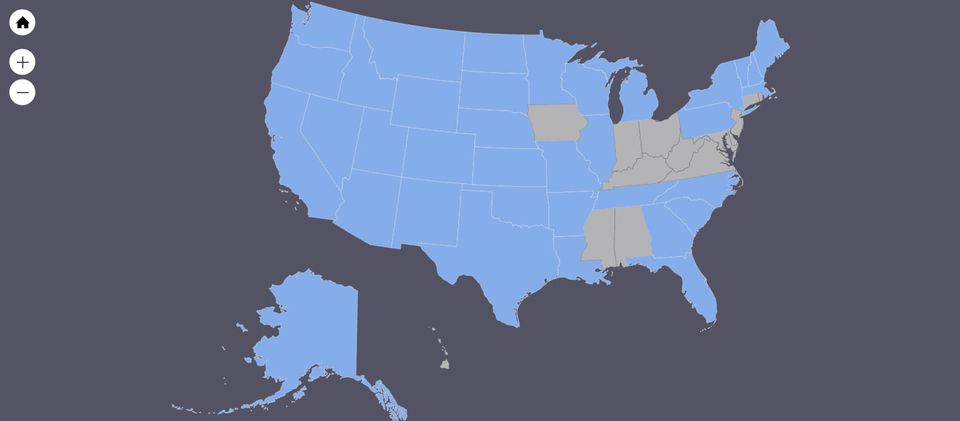
Fire Fighters Come from all over North America
Related Incident:
Publication Type: News
Did you know that often resources assisting on larger or longer duration fires are not always locals? Many of the teams and crews that come in to assist come from out of the area. This is a map highlighting all the states represented here on the