
State of Oregon Department of Forestry Fire Restrictions
Related Incident:
Publication Type: Closures
STATE OF OREGON - DEPARTMENT OF FORESTRY - FIRE RESTRICTIONS
REGULATED CLOSURE PROCLAMATION
Number 01
Effective 1:00 a.m., PDT, July 6, 2020
By virtue of the authority vested in me under the provisions of ORS 477.535 to 477.550, I hereby proclaim a Regulated Closure to be in effect in the following subject area:
All lands protected by the North Cascade Forest Protection District, and all lands within one-eighth mile thereof.
Under this Regulated Closure it is unlawful to be in violation of the following restrictions:
Smoking is prohibited while traveling, except in vehicles on improved roads, in boats on the water, and other designated locations.
Open fires, including campfires, charcoal fires, cooking fires and warming fires are permitted all day during low () fire danger with landowner permission. Open fires are only allowed at locations designated by the forester during moderate (high () fire danger. All open fires are prohibited during extreme fire danger (). Portable cooking stoves using liquefied or bottled fuels are allowed.
The use of power saws are permitted all day during low fire danger () and moderate fire danger (). During high fire danger, () saws are allowed before 1:00 p.m. and after 8 p.m. The use of power saws are prohibited during extreme fire danger (). Each power saw is required to have one shovel and one fire extinguisher of at least 8 ounce capacity. A Firewatch of at least one hour is required following the use of each saw.
Cutting, grinding and welding of metal is permitted all day during low fire danger () and during moderate fire danger (). During high fire danger () it is allowed before 1:00 p.m. and after 8 p.m. as long as it is conducted in a cleared area and has a charged garden hose or one 2 ½ pound or larger fire extinguisher immediately available. Cutting, grinding and welding of metal is prohibited during extreme fire danger ().
The mowing of dried, cured grass is permitted all day during low fire danger () and moderate fire danger (). During high fire danger () it is allowed before 1:00 p.m. and after 8 p.m. The mowing of dried, cured grass is prohibited during extreme fire danger (). The culture and harvest of agricultural crops is exempt from this requirement.
Motor vehicles, including motorcycles and all-terrain vehicles, on un-improved roads are permitted all day during low fire danger () and moderate fire danger (). During high fire danger () it is allowed before 1:00 p.m. and after 8 p.m. Motor vehicles, including motorcycles and all-terrain vehicles, on un-improved roads are
Air Quality Report and Forecast Sept 12 2020
Related Incident:
Publication Type: News
Air Quality Report and Smoke Summary are below.
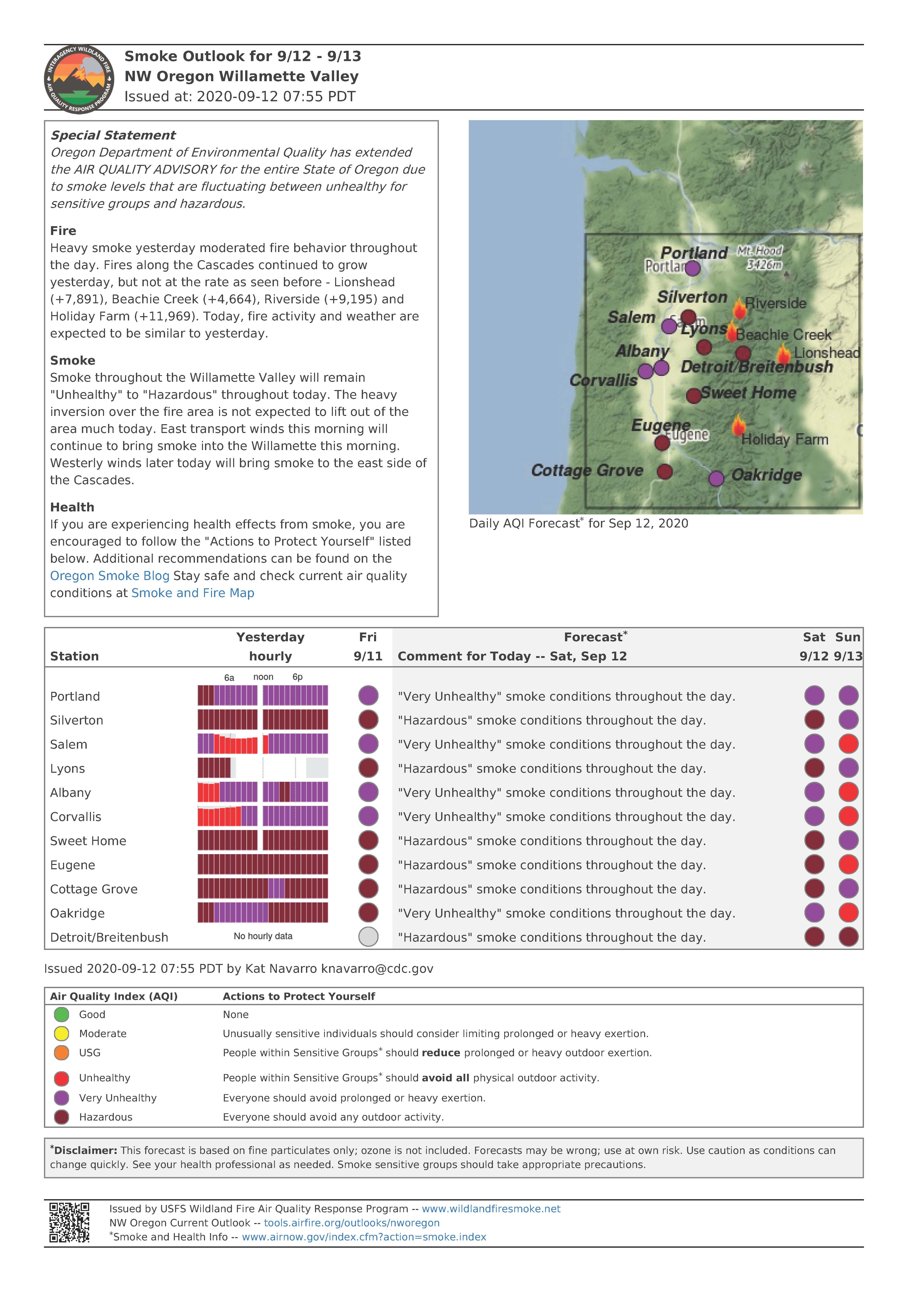
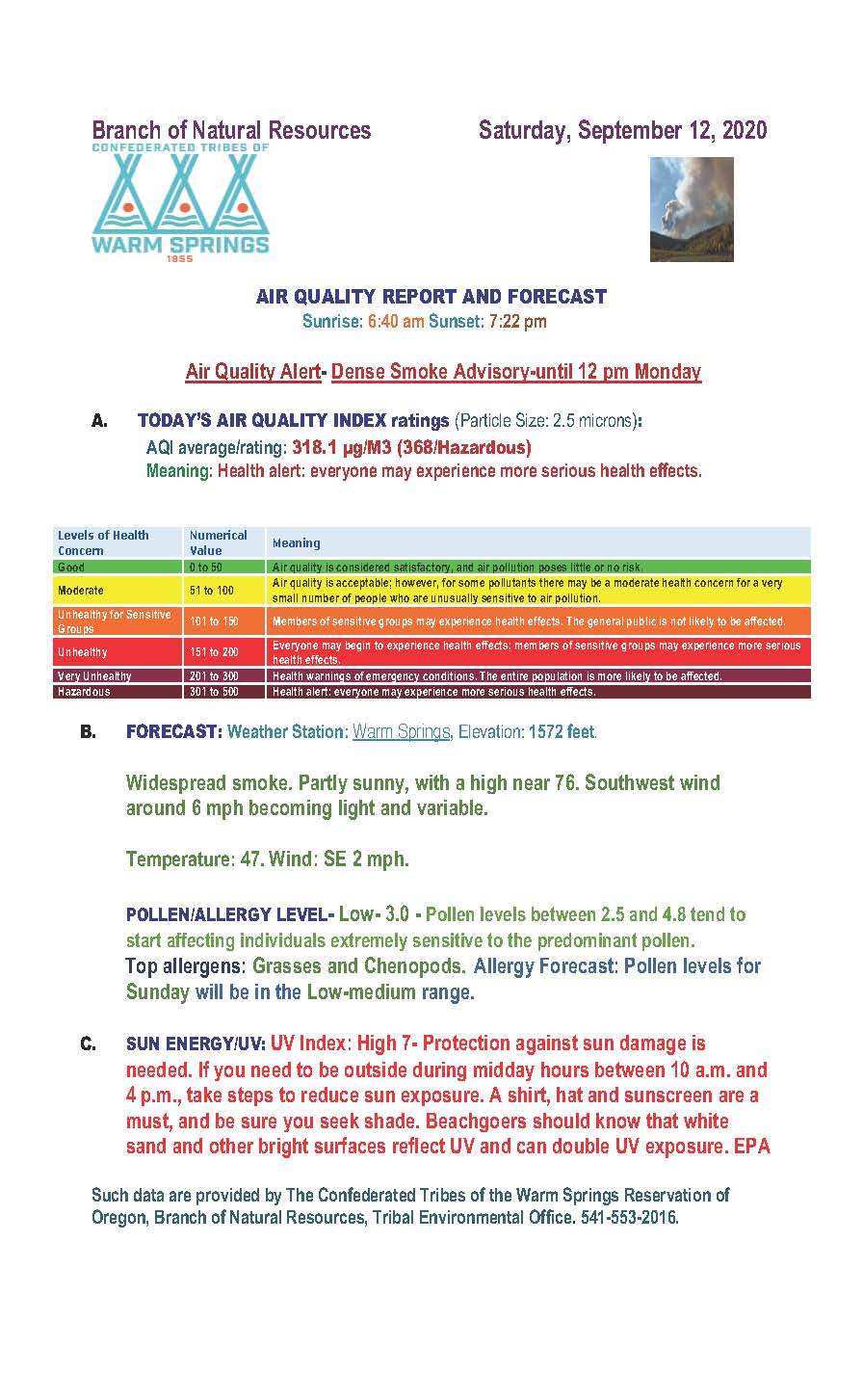
P515 and Lionshead Update Sept 12 2020
Related Incident:
Publication Type: News
Confederated Tribes of Warm Springs P-515 & Lionshead Fire Update - Saturday, September 12, 2020 – 9:00 a.m.
Virtual Community Meeting to be hosted on Lionshead Facebook Page today at 7:30 p.m. – We would like to encourage the public to email questions to 2020.lionshead@firenet.gov. You do not need to have a Facebook account to view the live meeting at www.facebook.com/lionsheadfire
Weather and Fire Behavior: Heavy smoke continues today from The Lionshead, Beachie Creek and Riverside Fires filling Central and Eastern Oregon on Friday with westerly winds. The heavy smoke should keep temperatures lower. Also, relative humidity much higher than predicted. Forecasted upper level winds should break the smoke layer free Monday followed later in the week by cooler temperatures and a possibility of light precipitation. Fire growth was minimal yesterday, some areas experienced surface fire carrying with minimal torching and short- range spotting. Extreme drought and dry fuels continue give the potential for extreme fire behavior.
Current Situation: The P-515 fire has burned 4,609 acres and is being utilized as an anchor point to battle the Lionshead fire which has burned approximately 136,346 acres. Crews working the eastern side of the Lionshead Fire located on the Warm Springs Reservation, continued to make great progress widening containment lines with strategic firing operations yesterday. Hand-crews, dozers and aerial support continue to secure line around secure new lines around the B-210 road leading to Trout Lake and P-500 road in between the P-515 and Lionshead fires. Containment lines around Olallie lake and to the east on to the Warm Springs Reservation will continue to be prepared today for planned strategic firing to harden the fire line. The fires footprint did not grow to the east as they enhanced and mopped up existing areas of containment. They performed firing operations to widen and secure fire breaks of the south eastern flanks around the J-100 road series to tie the fires edge into old lava beds to the south west of Mt Jefferson. Strategies are being discussed on containment options to be used to go west over the crest of the cascades. Strategies are shifting slowly from evacuations, road closures and structure protection to fire containment.
Today’s Activities: On the Warm Springs Reservation, firefighters will continue hardening containment, keeping close watch on the fire as the winds return to the westerly flow. Handline and dozer line will continue to be put in where needed, laying hose lays and mopping up areas along control lines that have heat. Crews will watch for any spot fires that may come from the change in winds or fire growth outside the fire area. Air resources are available to help the firefighters on the ground but will be dependent on visibility due to smoke. Pockets of unburned fuels within the fire have potential to torch and put up large columns of smoke.
Evacuations: There are currently no orders for evacuation on the reservation. The Oregon Office of Emergency Management has created an interactive database to help provide the most up to date information on evacuation statewide. https://www.oregon.gov/oem/emops/Pages/RAPTOR.aspx
Closures: Trout Lake Road at pavement end; Road B140 at Potter’s Pond; Road B210 and Road P-500. All trails south of Trout Lake, west of M-120 Metolius Bench, east of Mt. Jefferson, and north of J-195 will be closed to the public. Tenino Road (P-200) is closed to the public, with only fire personnel and residents are allowed. For public and firefighter safety, roads and trails on the southwest portion of the Warm Springs Reservation near the fires are closed to the public. Forest closures are in place for Deschutes, Mt. Hood and Willamette National Forests. A Temporary Flight Restriction is in place over the P-515, Lionshead & Beachie Creek Fire. Wildfires are a No Drone Zone. Deschutes NF Alerts Willamette NF Alerts Mt. Hood NF Alerts
FOR ADDITIONAL FIRE INFORMATION: Fire Information: 971-277-5075
Inciweb: https://inciweb.nwcg.gov/incident/7049/
Facebook: www.facebook.com/LionsheadFire
Email: 2020.lionshead@firenet.gov
Open Burning Ban for Reservations in Oregon and Washington
Related Incident:
Publication Type: Announcement
Due to the unhealthy and hazardous air quality conditions in Oregon and Washington, EPA has issued a Burn Ban on all Tribes in this region until further notice. EPA will meet again on Monday, September 13, 2020 to assess the conditions.
Tim Outman, Air Quality Specialist
EPA Air Quality Advisory and Open Burning Ban for Reservations in Oregon and Washington
(Seattle – Friday, Sept. 11, 2020) The U.S. Environmental Protection Agency (EPA) Region 10 has issued a ban on open burning for all reservations in Oregon and Washington State, due to smoke from large wildfires. This ban takes effect immediately and will remain in effect until further notice.
The burn ban applies to all outdoor and agricultural burning—including camping and recreational fires—in all areas within external reservation boundaries regardless of ownership or tribal membership. Ceremonial and traditional fires are exempt from the burn ban. For areas outside reservation boundaries, please contact your local clean air agency, fire department, or department of ecology.
EPA requests that reservation residents reduce all sources of air pollution as much as possible, including driving and idling of vehicles.
Air pollution can harm your health and can have lasting effects. Community cooperation with the ban will help people who are most at risk, including children, the elderly, pregnant women, people with asthma or difficulty breathing, diabetes, heart problems or otherwise compromised health. These sensitive groups should avoid outdoor exercise and minimize exposure to outdoor pollution as much as possible. Under the most severe pollution levels all residents should restrict their activities.
The burn ban is effective immediately. This burn ban may be downgraded or removed depending on air quality and weather conditions. Please check our website for the latest information: https://www.epa.gov/farr/burn-bans-indian-reservations-id-or-and-wa
# # #
To check conditions in your area, go to http://www.airnow.gov/ .
For current burn ban status, please visit https://waburnbans.net/, the tribal air quality office at (509) 865-5121 Ext. 6078 or 1-509-945-6675, or the EPA at 1-800-424-4372, email to R10_farrhotline@epa.gov.
Please check our website for the latest information: https://www.epa.gov/farr
# # #
Deschutes National Forest Closure 0601052006 Sisters Ranger District
Related Incident:
Publication Type: Closures
Deschutes National Forest Closure #06-01-05-20-06 is below.
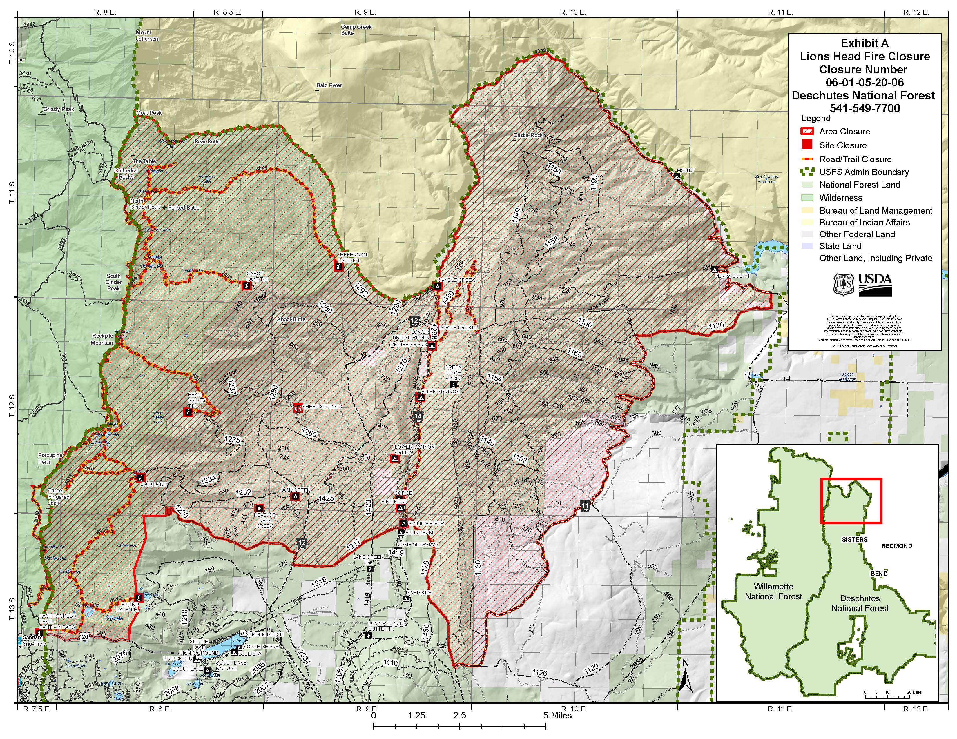
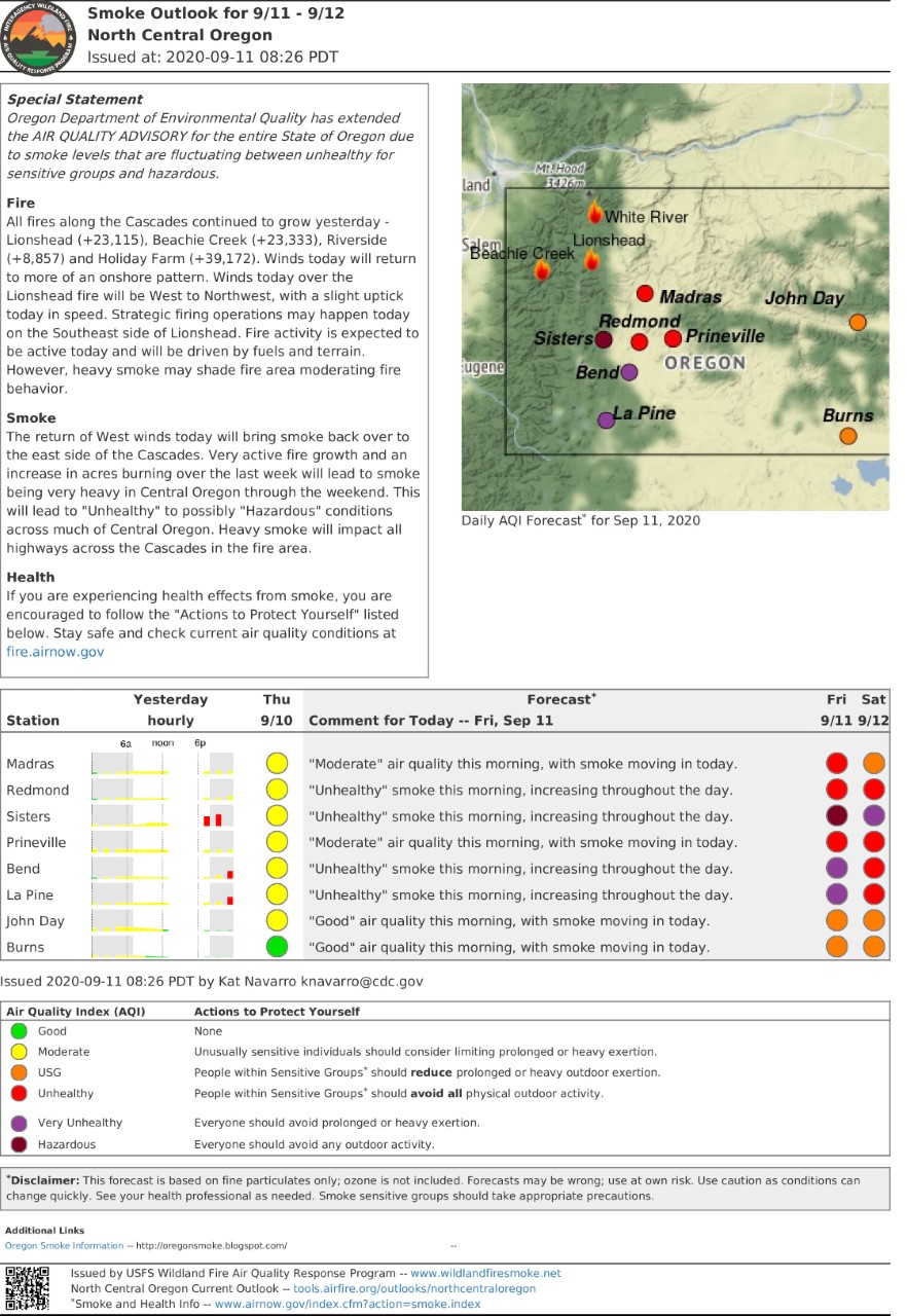
Air Quality Report and Forecast Sep 11 2020
Related Incident:
Publication Type: News
See attached for air quality reports.
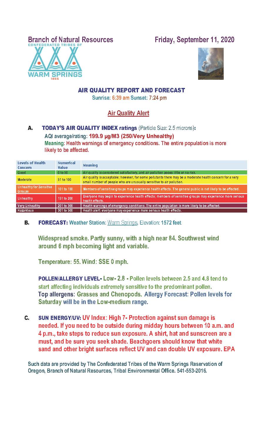
P515 and Lionshead Update Sept 11 2020
Related Incident:
Publication Type: News
Confederated Tribes of Warm Springs P-515 & Lionshead Fire Update – Friday, September 11, 2020 – 9:00 a.m.
Weather and Fire Behavior: West to northwest winds are expected today, 6-10 mph with gust up to 15 mph. The easterly transport winds are carrying over smoke to Central and Eastern Oregon not only from the Lionshead Fire but also from the Beachie Creek and Riverside Fires. Temperatures will be in the mid 70-80’s with very low relative humidity. Extreme drought and dry fuels continue give the east side of the crest equal potential for extreme fire behavior.
Current Situation: Crews working the eastern side of The Lionshead Fire located on the Warm Springs Reservation, continued to make great progress widening containment lines with strategic firing operations yesterday. Securing the eastern edges of the fire is critical in long term containment of the fire with the changing of the wind pattern to an easterly flow. Air resources supported the crews all day with fire-retardant, insuring to keep the eastern edge of the fire anchored in place. Hand-crews and dozers worked tirelessly continuing to construct line on the north and south boundaries of the fire. Strategies are being discussed on containment options to be used to go west over the crest of the cascades. West of the Warm Springs Reservation boundary the fire continues to grow, challenging firefighters with complex terrain and difficult access.
Today’s Activities: On the Warm Springs Reservation, firefighters will continue hardening containment, keeping close watch on the fire as the winds return to the westerly flow. Handline and dozer line will continue to be put in where needed, laying hose lays and mopping up areas along control lines that have heat. Crews will watch for any spot fires that may come from the change in winds or fire growth outside the fire area. Air resources are available to help the firefighters on the ground but will be dependent on visibility due to smoke. Pockets of unburned fuels within the fire have potential to torch and put up large columns of smoke. On the most southern flank, crews will continue to insert hose lays in areas inaccessible by fire engines to support the southern fire boundary. South of Mt. Jefferson there are unburned pockets of forest that have potential to burn if ground fire finds its way into the area. West of the reservation boundary firefighters will continue to scout for possible southern containment locations. On the north side of the fire, firefighters will continue to work their way through the area, although active fire and hazards in the burned area make accessing infrastructure treacherous.
Evacuations: There are currently no orders for evacuation on the reservation. The Oregon Office of Emergency Management has created an interactive database to help provide the most up to date information on evacuation statewide. https://www.oregon.gov/oem/emops/Pages/RAPTOR.aspx
Closures: Trout Lake Road at pavement end; Road B140 at Potter’s Pond; Road B210 and Road P-500. All trails south of Trout Lake, west of M-120 Metolius Bench, east of Mt. Jefferson, and north of J-195 will be closed to the public. Tenino Road (P-200) is closed to the public, with only fire personnel and residents are allowed. For public and firefighter safety, roads and trails on the southwest portion of the Warm Springs Reservation near the fires are closed to the public. Forest closures are in place for Deschutes, Mt. Hood and Willamette National Forests. A Temporary Flight Restriction is in place over the P-515, Lionshead & Beachie Creek Fire. Wildfires are a No Drone Zone. Deschutes NF Alerts Willamette NF Alerts Mt. Hood NF Alerts
FOR ADDITIONAL FIRE INFORMATION: Fire Information: 971-277-5075
TripCheck: https://www.tripcheck.com/.
Inciweb: https://inciweb.nwcg.gov/incident/7049/
Facebook: www.facebook.com/LionsheadFire
Email: 2020.lionshead@firenet.gov
P515 and Lionshead Update Sep 10 2020
Related Incident:
Publication Type: News
Confederated Tribes of Warms Springs P-515 & Lionshead Fire Update Thursday, September 10, 2020 – 9:00 a.m.
Weather and Fire Behavior: Morning winds from the southeast are expected to shift to the northwest this afternoon, promoting fire spread back to the south and east. Temperatures will be in the 70s with minimum relative humidity in the teens. Drought conditions, higher temperatures and low relative humidity will continue to contribute to the active fire behavior.
Air Quality Report and Forecast Sep 10 2020
Related Incident:
Publication Type: Announcement
Please see attached Air Quality Report and Forecast Sep. 10, 2020
P515 and Lionshead Update Sep 9 2020
Related Incident:
Publication Type: News
The Pacific Northwest experienced historic fire activity over the last two days. Continued easterly winds have pushed the Lionshead Fire to grow to 105,340 acres.
Weather and Fire Behavior: Temperatures will be warmer with slightly lower humidity levels than yesterday. Easterly winds will persist through most of the day, changing to southeast in the late afternoon. East winds will decrease; however, drought conditions, high temperatures and low relative humidity will contribute to continued active fire behavior.
Current Situation: Extreme drought conditions combined with strong easterly winds, due to a cold front, pushed the fire spread west over the crest of the cascades and north of Mt. Jefferson. Long range spotting contributed to more than 12 miles of fire spread that included the areas around Breitenbush and Detroit Lake. The fire also crossed highway 22 in multiple places. Fire personnel coordinated with local emergency services on evacuations, providing escort for residents and campers. Crews on the Warms Springs Reservation portion of the fire took advantage of the easterly winds to prepare and strengthen indirect containment lines. On the eastern and southern flanks of the fire, crews worked to clear roads in anticipation of a return to westerly prevailing winds to prevent the fire from moving toward Warm Springs and the Metolius Basin.
Today’s Activities: Safety of firefighters and the public remains our highest priority. Firefighters will continue to assist with any necessary evacuations as needed. Crews will assess and provide protection to structures at risk in the Detroit area. On the west side of the crest of the cascades, fire crews will scout from the north and south to determine locations for containment lines. To the south fire crews will be looking for access in the area around Idanha and Detroit area. On the Warm Springs Reservation firefighters will continue preparing roads to be used as containment lines on the northeast and southern side of the Lionshead Fire. Air resources will be available as needed to help with containment efforts.
Evacuations: Orders are being issued for evacuations as conditions change. Please monitor the local area sheriff’s department websites and Facebook for updates. (Deschutes, Jefferson, Wasco, Linn, and Marion counties)
Closures: For public and firefighter safety, roads and trails on the southwest portion of the Warm Springs Reservation near the fires are closed to the public. Forest closures are in place for Deschutes, Mt. Hood and Willamette National Forests. For more information about forest closures, please refer to National Forest websites.
Deschutes NF Alerts Willamette NF Alerts Mt. Hood NF Alerts
A Temporary Flight Restriction is in place over the P-515 and Lionshead Fires. Wildfires are a No Drone Zone.
FOR ADDITIONAL FIRE INFORMATION:
TripCheck: https://www.tripcheck.com/. Inciweb: https://inciweb.nwcg.gov/incident/7049/ Facebook: www.facebook.com/LionsheadFire Email: 2020.lionshead@firenet.gov
Fire Information: 971-277-5075