
19092020 la actualizacin diaria del Bobcat Fire
Related Incident:
Publication Type: News
la actualización diaria
ESTADISTICAS DE INCIDENTE
Ubicación de origen: Angeles National Forest, Azusa, CA
Fecha de inicio: 6 de sept. de 2020
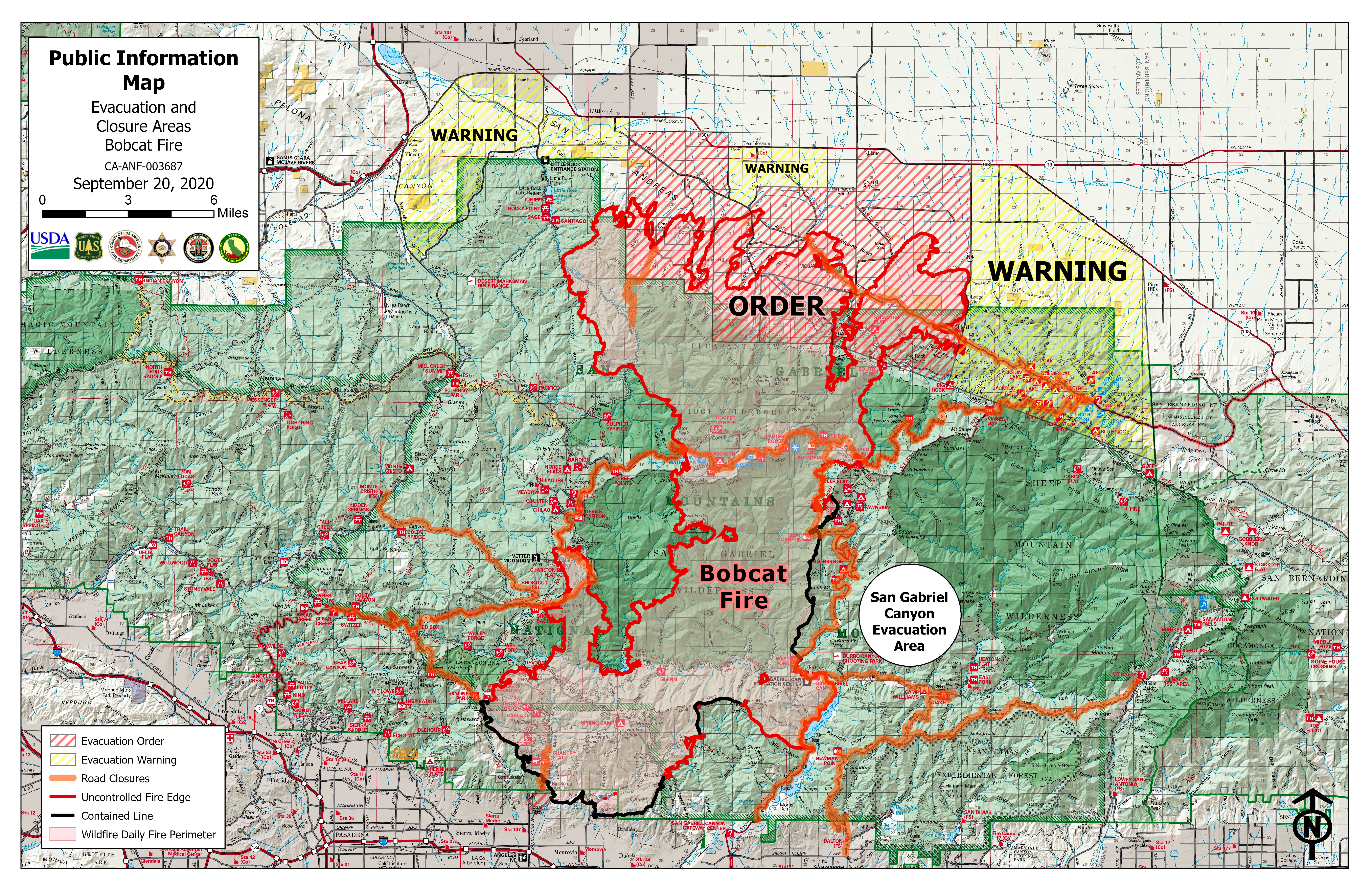
Tamaño: Aprox. acres 91,017
Porcentaje contenido: 15%
Causa: bajo investigación
Recursos asignados: 1,663 empleados
HOY:
Ayer, el incendio provocó un movimiento significativo impulsado por el viento e impactó a las comunidades de Juniper Hills, Valyermo y Big Rock Springs. Se emitieron numerosas órdenes de evacuación y advertencias. Hoy los equipos se concentrarán en asegurar el perímetro del fuego en el norte en un esfuerzo por detener cualquier propagación adicional, especialmente a las comunidades en el noreste y noroeste. En el perímetro sur, los equipos también continúan limpiando en la medida necesaria para garantizar que no haya más impactos en las estructuras. En el oeste, los bomberos continuarán protegiendo el Mt. Wilson y Chilao. A lo largo del corredor de la Ruta Estatal 39, los equipos estarán asegurando y limpiando donde ocurrió las operaciones estratégicas del encender ayer. Debido a las ráfagas de viento pronosticadas, es muy importante estar alerta a cualquier orden de evacuación o advertencia adicional que pueda ocurrir hoy. Para obtener información sobre evacuaciones, siga el Twitter del alguacil de Los Ángeles en @LASDHQ o https://bit.ly/35Uy9Ld
AYER:
Ayer el fuego estuvo muy activo debido a las condiciones de mucho viento. El fuego llegó a Juniper Hills y las comunidades adyacentes; las viviendas se vieron amenazadas e impactadas. Se llevó a cabo una operación estratégica del encender para establecer una línea segura entre la cicatriz del incendio Ranch 2 y la Ruta Estatal 39. En otras partes, los bomberos tuvieron éxito en mejorar y asegurar las líneas.
CLIMA:
Hoy las temperaturas disminuirán ligeramente con temperaturas aún en los 80 y 90 grados. Los vientos continuarán siendo muy fuertes y se pronostican con ráfagas de hasta 40 km / h. Las humedades relativas siguen estando por debajo de los 20 y tan bajas como un dígito.
ALERTAS DE EVACUACION:
Órdenes de evacuación: (Para más órdenes y alertas de evacuación: inciweb.nwcg.gov “Bobcat”)
- Al norte de Angeles Crest North y entre Clear Creek Station y Hwy 39
- Incluyendo el área al este de Devils Punch Bowl Rd, al sur de Big Pines Hwy, al norte de Big Rock Creek y al oeste de Jackson Lake.
-Acueducto: sur de Pearblossom Hwy (SR138), norte de Big Pines, este de 165th y oeste de Largo Vista Rd
-Ward- Al norte de Fort Tejon Rd, al sur de Avenue V, al este de 87th E., al oeste de 121 St E.
-Longview-Sur de la avenida 12, norte de acueducto, oeste de 165 St E y este de 121 St E.
-Tejon: al sur de Fort Tejon Rd, al norte de Cooley Place, al este de 89th St. E. y al oeste de Longview Rd.
-Peach: al norte de Pallett Creek, al sur de W.114th St., al este de Longview Rd y al oeste de 165th St.
- Cima Block - 96th este hasta 116th St. E / Fort Tejon Rd sur hasta SR 2
-Juniper Block- 116th E hasta Devis Punchbowl Rd / Fort Tejor Rd hasta SR 2
-Punchbowl Block - Devils Punchbowl Rd hasta el campamento Fenner incluido
-Paradise Block - Fenner Camp hasta la intersección de SR 2 y Big Pines
-Chilao, CalTrans Yard, el área de 3 puntos y el campamento cristiano de Angeles Crest recibieron órdenes de evacuación. El área de Crystal Lake permanece bajo la orden de evacuación.
Advertencias de evacuación:
Las advertencias de evacuación siguen vigentes para las comunidades de Wrightwood, Monrovia, Bradbury, Sierra Madre, Arcadia, Altadena, Duarte y Pasadena. Residentes al norte de Foothill Blvd. y al este de la Av. Santa Anita.
Se ha establecido un Centro de Evacuación de la Cruz Roja en Palmdale High School, 2137 E Avenue R, Palmdale, 93550. El primer punto de evacuación en Santa Anita Park ya está cerrado y cualquier persona que todavía necesite ayuda puede llamar a la Línea de Ayuda para Desastres al 800-675-5799. La Cruz Roja se compromete a ayudar a todos los afectados por el incendio Bobcat y las órdenes de evacuación.
RESUMEN:
El Bobcat Fire comenzó el 6 de septiembre a las 12:21. El incendio está ubicado cerca de la presa Cogswell y el área West Fork. El fuego arde en combustibles pesados con una rápida tasa de propagación.News articles for 91920
Related Incident:
Publication Type: News
News articles shared on social media 9/19/20:
https://losangeles.cbslocal.com/2020/09/18/angeles-forest-bobcat-fire-evacuation-mount-wilson/
https://ktla.com/news/local-news/homes-destroyed-after-winds-push-bobcat-fire-into-juniper-hills/
https://losangeles.cbslocal.com/2020/09/19/bobcat-fire-grows-to-91000-acres/
https://abc7.com/bobcat-fire-spreads-to-91017-acres;-evacuation-orders-remain/6450578/
https://www.latimes.com/california/story/2020-09-19/bobcat-fire-explodes-to-91-000-acres-homes-burned-amid-heavy-winds
https://wildfiretoday.com/2020/09/18/bobcat-fire-continues-spreading-to-the-north/
https://www.latimes.com/california/story/2020-09-18/bobcat-fire-doubles-in-size-as-flames-creep-toward-antelope-valley
https://www.univision.com/local/los-angeles-kmex/fuertes-vientos-y-alerta-por-posibles-incendios-en-el-sur-de-california-este-fin-de-semana
https://abc7.com/bobcat-fire-updates-california-fires-map-juniper-hills/6450578/
https://www.pasadenastarnews.com/2020/09/19/bobcat-fire-grows-to-91000-acres-as-buildings-burn/
https://abc7.com/bobcat-fire-spreads-to-91k-acres;-evacuation-orders-remain/6450578/
Bobcat Morning Update 91920
Related Incident:
Publication Type: News
TODAY
Yesterday the fire made significant wind-driven runs and impacted the communities of Juniper Hills, Valyermo, and Big Rock Springs. Numerous evacuation orders and warnings were issued. Today crews will focus on securing the fire’s perimeter in the north in an effort to stop any additional spread, especially to the communities in the northeast and northwest. On the southern perimeter personnel also continue to mop up to the extent necessary to ensure there is no further impact to structures. On the west crews will continue to protect Mt. Wilson and Chilao. Along the Highway 39 corridor crews will be securing and mopping up where the strategic firing occurred yesterday. It is very important to be alert for any additional evacuation orders or warnings that might take place today due to forecasted gusty winds. For information on evacuations follow Los Angeles Sheriff’s Twitter at @LASDHQ or https://bit.ly/35Uy9Ld
YESTERDAY
Yesterday the fire was very active due to the very windy conditions, the fire reached Juniper Hills and the adjacent communities, homes were threatened and impacted. A strategic firing operation occurred to establish a secure line between the Ranch 2 Fire scar and Highway 39. Elsewhere on the fire crews had success improving and securing lines.
WEATHER
Today temperatures will be slightly diminished with temperatures still in the 80’s and 90’s. Winds will continue to be very strong and forecasted with gusts of up to 25mph. Relative humidities continue to be in the teens and single digits.
EVACUATION ALERTS
Evacuation Orders (For more evacuation orders & alerts, visit: inciweb.nwcg.gov & search “Bobcat”):
- North of Angeles Crest North and between Clear Creek Station and Hwy 39..
- Including the area East of Devils Punch Bowl Rd, South of the Big Pines Hwy, North of the Big Rock Creek, and West of Jackson Lake.
-Aqueduct - South of Pearblossom Hwy (SR138), North of Big Pines, East of 165th and West of Largo Vista Rd
-Ward- North of Fort Tejon Rd, South of Avenue V, East of 87th E., West of 121 St E.
-Longview-South of Avenue 12, North of Aqueduct, West of 165 St E and East of 121 St E.
-Tejon - South of Fort Tejon Rd, North of Cooley Place, East of 89th St. E. and West of Longview Rd.
-Peach - North of Pallett Creek, South of W. 114th St., East of Longview Rd and West of 165th St.
- Cima Block - 96th east to 116th St. E/Fort Tejon Rd south to SR 2
-Juniper Block- 116th E to Devis Punchbowl Rd / Fort Tejor Rd to SR 2
-Punchbowl Block - Devils Punchbowl Rd to and including Fenner Camp
-Paradise Block - Fenner Camp to intersection of SR 2 and Big Pines
-Chilao, the CalTrans Yard, the 3 Points area and the Angeles Crest Christian Camp were all issued Evacuation Orders Crystal Lake area remains under Evacuation Order.
Evacuation Warnings:
Evacuation Warnings remain in effect for the communities of Wrightwood, Monrovia, Bradbury, Sierra Madre, Arcadia, Altadena, Duarte and Pasadena. Residents north of Foothill Blvd. and east of Santa Anita Ave.
A Red Cross Evacuation Center has been established at Palmdale High School, located at 2137 E Avenue R, Palmdale, 93550. The first evacuation point at Santa Anita Park is now closed and anyone still needing assistance can call the Disaster Distress Hotline at 800-675-5799. The Red Cross is committed to helping all those affected by the Bobcat Fire and evacuation orders.
SUMMARY:
The Bobcat Fire started on September 6th at 12:21 PM. The fire is located near the Cogswell Dam and West Fork Day Use area. The fire is burning in heavy fuels with a rapid rate of spread.
Press Conference 630 PM 91820
Related Incident:
Publication Type: Announcement
The Unified Incident Command for the #BobcatFire will be holding a press conference at the Santa Fe Dam Recreation Area at 6:30 pm today to announce structure loss on the Fire.
EVACUATION WARNING AS OF 1700 91920
Related Incident:
Publication Type: Closures
A NEW EVACUATION WARNING has been issued for the following area (1700 9/19/20):
- South of Pearblossom Hwy, East and North of Angeles Forest Hwy, North and West of Mt. Emma Rd., East and South of Hwy 122, and West of Cheseboro Rd
Evacuation Warnings have been Issued for the following area:
-South of East Ave V, North of Fort Tejon Rd, West of 121st East, East of 87th St, East.
-South of East Ave U-12, North of East Av W-14, West of 165th St East, East of 121st East.
-South of Pearblossom Hwy, North of Weber Ranch Rd, West of 87Th Street East, East of Cheseboro Rd.
• South of Big Pines Hwy and Hwy 2, North of Blueridge Truck Trail (NF-3N06), West of Los Angeles Co./San Bernadino Co. border, East of Fenner camp
• South of 138th St East, North of Big Pine Hwy and Hwy 2, West of 263rd East, East of Largo Vista Rd.
EVACUATIONS AS OF 1430 91920
Related Incident:
Publication Type: Closures
New Evacuation Order 1430 9/19/20:
- South of 138th St East, North of Big Pines Hwy and Hwy 2, West of 263rd East, East of Largo Vista Rd.
Evacuation Orders
- North of Angeles Crest North and between Clear Creek Station and Hwy 39..
- Including the area East of Devils Punch Bowl Rd, South of the Big Pines Hwy, North of the Big Rock Creek, and West of Jackson Lake.
-Aqueduct - South of Pearblossom Hwy (SR138), North of Big Pines, East of 165th and West of Largo Vista Rd
-Ward- North of Fort Tejon Rd, South of Avenue V, East of 87th E., West of 121 St E.
-Longview-South of Avenue 12, North of Aqueduct, West of 165 St E and East of 121 St E.
-Tejon - South of Fort Tejon Rd, North of Cooley Place, East of 89th St. E. and West of Longview Rd.
-Peach - North of Pallett Creek, South of W. 114th St., East of Longview Rd and West of 165th St.
- Cima Block - 96th east to 116th St. E/Fort Tejon Rd south to SR 2
-Juniper Block- 116th E to Devis Punchbowl Rd / Fort Tejor Rd to SR 2
-Punchbowl Block - Devils Punchbowl Rd to and including Fenner Camp
-Paradise Block - Fenner Camp to intersection of SR 2 and Big Pines
-Chilao, the CalTrans Yard, the 3 Points area and the Angeles Crest Christian Camp were all issued Evacuation Orders Crystal Lake area remains under Evacuation Order.
Smoke Outlook for 91820
Related Incident:
Publication Type: News
Smoke advisories are still in place for the #BOBCATFIRE. Southwest winds will carry the smoke northeast of the fires, which will transport smoke into the downwind mountain and desert communities. Air quality will continue to be much improved in the LA Basin and Inland Empire. For more info see: http://www.aqmd.gov/
Evacuation Order East of Hwy 39
Related Incident:
Publication Type: Closures
Evacuation Order has been issued for the following area:
-Evacuation Order includes areas east of Hwy 39, south of East Fork Rd, west of GMR, and north of Glendora Ridge Rd.
1892020 ACTUALIZACIN Bobcat Fire
Related Incident:
Publication Type: News
la actualización diaria
ESTADISTICAS DE INCIDENTE
Ubicación de origen: Angeles National Forest, Azusa, CA
Fecha de inicio: 6 de sept. de 2020
Tamaño: Aprox. acres 60,557
Porcentaje contenido: 15%
Causa: bajo investigación
Recursos asignados: 1,300 empleados
HOY:
Se han emitido órdenes de evacuación para Juniper Hills, Devil’s Punchbowl y Paradise Springs, incluida el área al este de Devils Punch Bowl Rd, al sur de Big Pines Hwy, al norte de Big Rock Creek y al oeste de Jackson Lake. Hoy nuestro enfoque principal será responder a las amenazas a las comunidades en el extremo norte del incendio. Una combinación de recursos aéreos y terrestres funcionará para detener el avance del fuego mientras se cuenta con la protección de la estructura. Alrededor del Mt. Wilson Los equipos continuarán manteniendo y mejorando las líneas que protegen la infraestructura mientras intentan evitar que el fuego se extienda hacia el oeste alrededor de la montaña. En el lado este, los bomberos continuarán patrullando y detectando cualquier incendio puntual. Buscarán oportunidades para establecer líneas de control directo para reducir la propagación del fuego. En el sur, los equipos continuarán limpiando y fortaleciendo la línea alrededor de las comunidades. Anoche se llevó a cabo una reunión de la comunidad virtual en la que los representantes del incendio proporcionaron una actualización sobre la situación del Bobcat Fire. Se publicará una versión grabada de la reunión en las páginas de Facebook, del Depart. de Bomberos del Condado de Los Ángeles o la de la Ciudad de Monrovia y Bobcat Inciweb.
AYER:
Ayer, el fuego alcanzó Juniper Hills y las comunidades cercanas, pero la actividad del fuego se moderó a medida que se acercaba a las laderas más bajas y al fondo del valle. Se asignaron más recursos para responder a esta amenaza. Los esfuerzos para proteger Mt. Wilson siguió teniendo éxito. De la noche a la mañana, en el este, el fuego avanzó cuesta abajo sobre el embalse de San Gabriel. En el sur, el fuego alrededor de las comunidades se encuentra ahora en estado de patrullaje y limpieza.
CLIMA:
Hoy permanecerá cálido y muy seco. Los vientos serán del suroeste y serán más fuertes en las crestas del norte al final de la tarde y en la noche. Los vientos son potencialmente de 20 a 30 MPH en las cimas de las crestas y de 10 a 15 MPH en los valles. La humedad aumentará el sábado.
ALERTAS DE EVACUACION:
Órdenes de evacuación:
- North of Angeles Crest North and between Clear Creek Station and Hwy 39.
- Juniper Hills.
- Devils Punchbowl.
- Paradise Springs.
- Including the area East of Devils Punch Bowl Rd, South of the Big Pines Hwy, North of the Big Rock Creek, and West of Jackson Lake.
Advertencias de evacuación: Las advertencias de evacuación permanecen vigentes para las comunidades de Monrovia, Bradbury, Sierra Madre, Arcadia, Altadena, Duarte y Pasadena. Residentes al norte de Foothill Blvd. y al este de Santa Anita Ave y los residentes de Wrightwood también permanecen en una advertencia.
Se ha establecido un Centro de Evacuación de la Cruz Roja en el Parque Santa Anita, ubicado en 285 Oeste Huntington Drive, Arcadia, CA, 91007. Se recomienda a los residentes que ingresen por la Puerta 5. Para Red Cross LA, llame 1-800-675-5799
RESUMEN:
El Bobcat Fire comenzó el 6 de septiembre a las 12:21. El incendio está ubicado cerca de la presa Cogswell y el área West Fork. El fuego arde en combustibles pesados con una rápida tasa de propagación.
News Articles on the Bobcat Fire 91820
Related Incident:
Publication Type: News
Want to see what is being written about the Bobcat Fire? The following articles are being shared on social media on September 18, 2020:
https://www.latimes.com/california/story/2020-09-18/bobcat-fire-doubles-in-size-as-flames-creep-toward-antelope-valley
https://www.sgvtribune.com/2020/09/18/bobcat-fire-swells-to-more-than-60000-acres-firefighters-focus-on-northern-edge/?utm_medium=social&utm_content=tw-SGVTribune&utm_source=twitter.com&utm_campaign=socialflow
https://www.sfchronicle.com/california-wildfires/article/fires-live-updates-Vacaville-Santa-Cruz-California-15495508.php
https://www.npr.org/2020/09/16/913649688/firefighters-battle-to-save-las-historic-mt-wilson-observatory
https://www.newsbreak.com/news/2064530126659/bobcat-fire-still-growing-threatens-several-high-desert-communities?s=oldSite&ss=a2
https://laist.com/latest/post/20200918/bobcat-fire-day13
https://abc7.com/bobcat-fire-updates-california-fires-map-juniper-hills/6437178/
https://www.mercurynews.com/2020/09/18/map-bobcat-fire-evacuations-in-los-angeles-county/
https://www.the-scientist.com/news-opinion/california-wildfire-beaten-back-for-now-on-famous-mt-wilson-67939?utm_content=140190166&utm_medium=social&utm_source=twitter&hss_channel=tw-18198832