
Forest Service to Increase Access to National Forests in California
Related Incident:
Publication Type: Closures
VALLEJO, Calif. – The USDA Forest Service Pacific Southwest Region announces increased access to some National Forests in California beginning at 8:00 a.m. on Saturday, September 19, 2020.
The prohibition of the use of any ignition source on all National Forest System lands (campfires, gas stoves, etc.) throughout California remains in place.
Nine National Forests in California remain closed: Angeles NF, Cleveland NF, Los Padres NF, Inyo NF, Klamath NF, San Bernardino NF, Sequoia NF, Sierra NF, and Six Rivers NF. This decision will continue to be reviewed daily with evolving fire and weather conditions.
Nine other National Forests may open to varying degrees. Visitors should contact the following National Forests for more information on their status: Eldorado NF, Lake Tahoe Basin Management Unit, Lassen NF, Mendocino NF, Modoc NF, Plumas NF, Shasta-Trinity NF, Stanislaus NF, and the Tahoe NF. These forests will implement their own forest orders that will either limit dispersed use or provide for area closures around fires.
Conditions can change quickly. Therefore, we emphasize that all citizens heed local announcements for changes in conditions and potential evacuations.
"We understand how important access to the National Forests is to our visitors," said Randy Moore, Regional Forester for the USDA Forest Service Pacific Southwest Region. "Continued closures are essential based on extreme fire conditions, critical limitations of firefighting resources, and to provide for firefighter and public safety.”
Again, visitors are encouraged to contact their local National Forest for more information. We have developed a web map to help visitors find out which sites are open. Visit our online map at https://www.fs.fed.us/r5/webmaps/RecreationSiteStatus/. For additional questions, please contact your local National Forest.
The Forest Service manages 18 National Forests in the Pacific Southwest Region, which encompasses over 20 million acres across California, and assists State and Private forest landowners in California, Hawaii and the U.S. Affiliated Pacific Islands. National forests supply 50 percent of the water in California and form the watershed of most major aqueducts and more than 2,400 reservoirs throughout the state. For more information, visit www.fs.usda.gov/R5.
Informacin Actualizada de los Incendios SlaterDevil Jueves 18 de Sept
Related Incident:
Publication Type: News
Resumen
Incendio Slater: Continuamos con las operaciones que implementaran estrategias de fuego directas e indirectas en el sitio. Este trabajo incluye completar las líneas hechas por bulldozers desde Monkey Ridge hasta el Highway 199. Cerca de Shepherd Hills, sobre el lado norte del incendio, los bomberos lograron regresar una mancha pequeña del incendio hacia la carretera forestal 4803.
El grupo Northern Rockies Team 2 continúa trabajando con el Jefe Estatal de bomberos, con el Departamento Forestal de Oregon, así como con otras agencias a nivel local y federal con el fin de contener la propagación del Incendio Slater. El día de hoy, la prioridad para los bomberos es proteger las propiedades privadas en la zona sur de Thompson Creek. Algunos fuegos aislados continúan quemando el terreno del Incendio Slater introduciéndose al drenaje de este. La prioridad secundaria para el día de hoy consiste en limpiar a lo largo de la mayor parte del eje con fuegos apagados cerca del Highway 96 para que de esta forma las operaciones de fuego puedan movilizarse fuera del corredor del área afectada.
También se continúa limpiando alrededor del pueblo de Happy Camp y al mismo tiempo se cerrara el área de Grayback Road para reparaciones de postes de electricidad. También se continua con la construcción de líneas de fuego indirectas a lo largo del lado Norte de Seiad Valley. Sobre el flanco oeste del incendio Slater ha habido muy poco crecimiento en el incendio durante estos días en la parte baja de Kelly Lake. El día de hoy, el incremento de la visibilidad podría dar como resultado que las operaciones de vuelo asistan de una mejor manera a los bomberos en tierra. Al mismo tiempo, la comunidad podrá observar la actividad del fuego más claramente.
El alguacil de Incendios para el Estado de Oregon tiene 11 fuerzas de trabajo para infraestructuras que se asignaron al Incendio Slater. Su misión primaria en el incendio es la protección de la ciudadanía, sus propiedades y el medio ambiente. Ellos se encuentran trabajando juntamente con los bomberos situados en tierras virgen.
Incendio Devil: Se cuenta con recursos que están participando en el incendio que está queriendo propagarse hacia Applegate Lake. El Incendio Devil permanece a lo largo de su costado oriental en el Pacific Crest Trail. Los bomberos están trabajando en las cordilleras afuera del borde noroeste del incendio con el fin de unirse con el resto de los bomberos en la zona norte. Estos últimos han logrado avanzar hasta el eje este del incendio y están buscando la forma de enganchar el fuego que cruza el lado norte del Incendio Devil. En estos momentos, el Incendio Devil tiene un tamaño aproximado de 7,144 acres.
Área de Gasquet: Los bomberos lograron mantener el fuego en Knopi Road para proteger el pueblo de Gasquet. Ellos estarán trabajando en completar operaciones que aseguren el fuego en el eje de la intersección del Highway 199 y Knopki Road.
Se continua con las actividades para proteger la infraestructura desde Knopki Road hasta el pueblo de Gasquet.
El día de hoy, a las 5:00 pm en el Distrito de Smith River localizado en Gasquet, se realizará una reunión informativa para la comunidad.
Slater Devil Fires Update September 18 2020
Related Incident:
Publication Type: News
Please note: The North Zone of the Slater Fire (currently including the Gasquet area and all of Oregon) is being managed by Northern Rockies Team 2 and the South Zone of the fire continues to be managed by California Team 10. Beginning tomorrow, this incident will transition to one morning update from Northern Rockies Team 2 encompassing both zones. Information for both fires will continue to be available at www.facebook.com/SlaterAndDevilFireInformation and on InciWeb at inciweb.nwcg.gov/incident/7173/
Fire Summary:
Slater Fire: Operations continued to implement direct and indirect fire strategies. Work included completing dozer line from Monkey Ridge to Highway 199. On the northern side of the fire near Shepherd Hills, crews were able to tie a small spot fire back into Forest Road 4803. Priorities for firefighters in the south zone today are to ensure that private properties in Thompson Creek are protected. Isolated pockets of fuel continue to burn as the Slater Fire backs down in that drainage. A secondary priority for today is to mop up along the mostly cold fire edge near Highway 96 so that fire operations can move out of the road corridor. Mop-up continues around the town of Happy Camp, while the Grayback Road will be closed this morning for power pole repair. Construction of indirect fireline along the north side of Seiad Valley continues. Along the Slater Fire’s west flank, there has been very little growth in the past several days below Kelly Lake. With increased visibility, air operations may be better able to assist firefighters on the ground today, and the public may be better able to see fire activity.
The Oregon State Fire Marshal has 11 structural task forces assigned to the Slater Fire. Their primary mission is to protect citizens, their property, and the environment from fire. They are working in conjunction with wildland crews.
Devil Fire: Resources are engaging the fire as it wants to spread toward Applegate Lake. The Devil Fire continued to hold along its eastern edge at the Pacific Crest Trail. Crews are working ridges just off the northeastern edge of the fire to meet crews working in the north zone. They have worked up the east edge of the fire and are looking for a way to hook the fire across the north side of the Devil Fire. The Devil Fire is at 7, 144 acres.
Gasquet Area:
Firefighters held the fire at the Knopki Road to protect the town of Gasquet. They will work to complete operations to secure the fire edge at the intersection of Highway 199 and Knopki Road. Structure protection activity continues from Knopki Road to the town of Gasquet. A community meeting will be held today at 5:00pm at the Smith River Ranger District located in Gasquet.
Slater and Devil Fires Evening Update Sept 17 2020
Related Incident:
Publication Type: News
FIRE SUMMARY
Please note: The North Zone of the Slater Fire (currently including the Gasquet area and all of Oregon) is being managed by Northern Rockies Team 2 and the South Zone of the fire continues to be managed by California Team 10. Beginning tomorrow, this incident will transition to one morning update from Northern Rockies Team 2 encompassing both zones. Information for both fires will continue to be available at www.facebook.com/SlaterAndDevilFireInformation and on InciWeb at inciweb.nwcg.gov/incident/7173/
North Zone: (Gasquet and Oregon) Slater Fire: Operations continued to implement direct and indirect fire strategies. Work included completing dozer line from Monkey Ridge to Highway 199. On the northern side of the fire near Shepherd Hills, crews were able to tie a small spot fire back into Forest Road 4803. Northern Rockies Team 2 continues to work with the Oregon State Fire Marshal, Oregon Department of Forestry and other local and federal agencies to contain the north spread of the Slater Fire.
Gasquet Area: Firefighters held the fire at the Knopki Road to protect the town of Gasquet. They will work to complete operations to secure the fire edge at the intersection of Highway 199 and Knopki Road. Structure protection activity continues from Knopki Road to the town of Gasquet.
South Zone: The air finally cleared out today along the Slater Fire in the south zone, and a chance of rain is predicted for tomorrow or Saturday. Crews worked today on hotspots in Thompson Creek, and on both flanks of the Devil Fire. A fire module is still camping out to construct direct fire line along the Devil fire’s eastern edge. Today they completed that eastern edge and started building line along the south side of that fire. For current information on evacuation and closures in this area: www.facebook.com/SiskiyouCountySheriff
EVACUATIONS
California: Some EVACUATION ORDERS have been lifted in Happy Camp. EVACUATION WARNINGS are still in place for most of Happy Camp including Elk Creek Road, and for Seiad along Highway 96, as well as for Gasquet, Hiouchi, and Big Flat.
Oregon: In Oregon, Level 3 “Go” orders are in effect in the O'Brien, and Takilma areas, Dick George Road (including most of Holland Loop) and Takilma Road areas, Brown Road, O'Brien and all areas south of Brown Road, O'Brien. EVACUATION WARNINGS are in effect for Gasquet in California, while nearby communities of Hiouchi and Big Flat are on Level 1 “Get Ready” alert. Level 2 “Get Set” orders are in effect south of Kerby and Cave Junction areas in Oregon.
MORE INFORMATION:
Community and evacuation information can be found at Siskiyou County Sheriff’s Office Facebook page at www.facebook.com/SiskiyouCountySheriff/.
For Del Norte County evacuation information, see www.facebook.com/DelNorteOfficeOfEmergencyServices or www.preparedelnorte.com/
Evacuation order/warning info and other resources for Josephine County can be found by calling Josephine County Fire Information Center 541-474-5305 (7am-10pm) or online at: www.facebook.com/josephinecountyEM , www.co.josephine.or.us/fire or www.rvem.org
ROAD CLOSURES
Highway 199 remains closed from Panther Flat (north of Gasquet) to the California/Oregon state line and from O’Brien south across the state line into California. Some other roads in Oregon are experiencing serious visibility impairments due to smoky conditions from the Slater Fire.
The Grayback Road is still closed. Highway 96 is open to one-way controlled traffic. Expect delays and use caution when traveling. Air quality is currently classified as hazardous. If you have questions, please contact the Siskiyou Emergency Operations Center at (530) 643-3662.
PUBLIC LAND CLOSURES
National Forest Closures, California: National Forests in California have been closed since September 9 and new closure orders have been issued to extend for one week. However, these orders are being assessed on a daily basis to consider cancelling. More details on these closure orders, along with fire restriction orders, can be found at inciweb.nwcg.gov/incident/7173/
National Forest Closures, Oregon:
The Wild Rivers and Siskiyou Mountains Ranger Districts are currently closed due to extreme fire danger. These closures cover all National Forest forested areas, developed campgrounds, dispersed camping, day use areas, wilderness areas, and all forest roads and trails within those two Districts.
Bureau of Land Management Closures: As a result of extreme fire danger, the Bureau of Land Management Medford District has temporarily closed all Bureau of Land Management-administered public lands south of Grants Pass, Interstate 5, and U.S. Route 199 to the border of the Rogue River-Siskiyou National Forest. Maps of the closure areas are available on the Bureau of Land Management’s website.
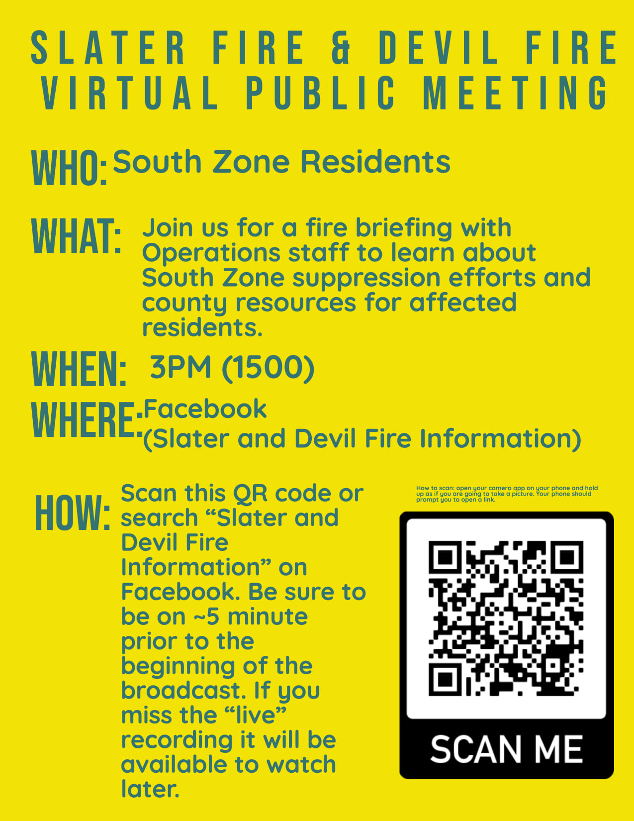
Slater and Devil Fire Virtual Meeting at 3pm
Related Incident:
Publication Type: Announcement
The California Interagency Incident Management Team 10 will host a virtual community meeting today at 3:00pm on the Slater and Devil Facebook Page at https://www.facebook.com/SlaterAndDevilFireInformation No account is required to view the video. We will monitor online Facebook questions during the meeting. A recording will be posted immediately following the live meeting.
Slater and Devil Fires Morning Update Sept 17 2020
Related Incident:
Publication Type: News
Slater and Devil Fire Morning Update for September 17, 2020, 9 a.m.
HAPPY CAMP, CALIFORNIA — The Slater and Devil Fire South Zone (Happy Camp to Seiad communities) will be holding a virtual public meeting at 3 p.m. today, September 17, 2020. Join us at facebook.com/SlaterAndDevilFireInformation.
Incident Commander Doug Turman and his Northern Rockies Incident Management Team 2 assumed command of the North Zone of the Slater Fire (including areas around Gasquet, California) yesterday. The South Zone of the Slater Fire and the Devil Fire will remain under command of California IIMT 10 for now. Information will still be disseminated at facebook.com/SlaterAndDevilFireInformation to avoid confusion.
NORTH ZONE: Near Gasquet, firelines are holding along Knopki Road, despite limited available resources there. Equipment operators are using bulldozers to establish control lines along Monkey Ridge to prevent the fire from crossing Highway 199.
The Oregon State Fire Marshal’s Office has mobilized 10 task forces of structural fire engines, six from Oregon, three from Utah, and one from Washington State. Today, operations continued to implement direct and indirect fire strategies. The heavy smoke inversion lifted late afternoon yesterday over the North Zone of the Slater Fire, causing increased fire activity, but fire personnel were able to maintain control lines in and around Illinois Valley. Note to Level 3 evacuees: We are working hard to get you back into your homes. Thank you for your patience as we work to ensure your safety. Northern Rockies Team 2 continues to work with the Oregon State Fire Marshal, Oregon Department of Forestry and other local and federal agencies to contain the northern spread of the Slater Fire.
SOUTH ZONE: A low-pressure system crossed over the Slater Fire area from west to east, clearing smoke out and increasing fire activity yesterday afternoon into last night. Firefighters were able to contain several spot fires on the west side of the Thompson Creek drainage yesterday. Air quality is expected to improve around Happy Camp today, although smoke levels are predicted to remain unhealthy.
Priorities for the Slater Fire South Zone today include preventing rolling material from crossing control lines along Highway 96 and protecting life and property in the Thompson Creek drainage, where fire is backing towards homes. Meanwhile, work continues to build direct and indirect fireline around Seiad to contain the Devil Fire, which spread to the west and northeast yesterday.
The Slater Fire has now burned an estimated 143,092 acres, while the Devil Fire is at roughly 6,907 acres, aerial heat detection flights show. The Slater Fire remains at 10 percent containment, while the Devil is still 0 percent contained.
The Fox Fire burning southwest of Callahan in the Klamath National Forest is now estimated at roughly 1,512 acres. EVACUATION ADVISORIES and ORDERS are in effect for the Callahan area due to this fire – see the Siskiyou County Sheriffs Facebook page for updated details. The Fox Fire has shown active fire behavior and produced intense heat. The Slater Fire’ South Zone is supporting suppression efforts on the Fox Fire until additional resources arrive. CALFIRE is also assisting in response to this fire. It is currently 0 percent contained.
Due to extreme fire danger, all National Forests in California closed September 9, and remain closed. More details on these closure orders, along with fire restrictions orders, can be found on National Forest websites and on InciWeb.
Due to public safety concerns associated with fire danger and fire activity, the Rogue River-Siskiyou National Forest (RRSNF) has temporarily closed the Wild Rivers Ranger District and the Siskiyou Mountains Ranger District. Closure orders and maps are available on the RRSNF website at https://www.fs.usda.gov/alerts/rogue-siskiyou/alerts-notices
As a result of extreme fire danger, the Bureau of Land Management Medford District has temporarily closed all Bureau of Land Management-administered public lands south of Grants Pass, Interstate 5, and U.S. Route 199 to the border of the Rogue River-Siskiyou National Forest. Maps of the closure areas are available on the Bureau of Land Management’s website: www.blm.gov/programs/public-safety-and-fire/fire-and-aviation/regional-info/oregon-washington/fire-restrictions.
Highway 199 remains closed from O’Brien south almost to Gasquet. Highway 96 is now open to one-way controlled traffic. Drivers traveling these sections of highway should expect delays and use caution due to increased fire traffic, poor visibility and possible falling trees or rolling material. Other highways in Oregon are also being impacted by the smoke.
EVACUATION INFORMATION:
Current evacuation orders are posted on Siskiyou County Sheriff’s Office Facebook page at www.facebook.com/SiskiyouCountySheriff/.
For Del Norte County evacuation information, see www.facebook.com/DelNorteOfficeOfEmergencyServices
Evacuation order/warning info and other resources for Josephine County can be found by calling Josephine County Fire Information Center 541-474-5305 (7am-10pm) or online at:
www.facebook.com/josephinecountyEM, www.co.josephine.or.us/fire, or www.rvem.org
Slater and Devil fires Evening Update September 16
Related Incident:
Publication Type: News
FIRE SUMMARY
Please note: as of 6 a.m. today, the northern portion of the Slater and Devil Fires (currently including the Gasquet area and all of Oregon) is being managed by Northern Rockies Team 2 and the southern portion of the fire continues to be managed by California Team 10. Information for both fires will continue to be available at www.facebook.com/SlaterAndDevilFireInformation and on InciWeb at inciweb.nwcg.gov/incident/7173/
North Zone: (Gasquet and Oregon) The Northern Rockies Incident Management Team #2 will be providing updates regularly starting tomorrow, Wednesday, September 16, 2020. Live daily operational briefings will be posted to the Slater and Devil Fire Facebook page at 10:00am and Slater Fire Inciweb page will be updated by mid-morning daily. Additionally, trapline and media needs were assessed by the team and the Northern Rockies Team 2 will continue to look for ways to engage with the community to fulfill informational needs. Note to Level 3 evacuees: We are working hard to get you back into your homes. We ask for your patience as we work to ensure your safety. Northern Rockies Team 2 will continue to work shoulder to shoulder with local fire, state, and federal firefighting resources to fight the north area of the Slater and Devil fires. For the latest information on evacuations, please visit: www.facebook.com/josephinecountyEM.
South Zone: The air cleared around the south zone of the Slater Fire today. Operational priorities continuing into tonight are falling hazard trees, monitoring the fire as it backs down to Highway 96, and conducting strategic firing to usher the fire safely down around structures in the Thompson Creek area. A wildland fire module is camping out along the Pacific Crest Trail tonight and will carry on prepping the trail as a containment line along the eastern edge of the Devil Fire. Evacuations have begun to lift in the Happy Camp area. The latest information on evacuations in and around Happy Camp are at: www.facebook.com/SiskiyouCountySheriff
Fox Fire: The Fox Fire was discovered September 14, burning southwest of Callahan on the Klamath National Forest. The fire is now estimated at 1,800 acres. With fire resources stretched so thin nationally, the Fox Fire is minimally staffed, with 43 personnel assigned including three crews and 2 dozers. The Slater Fire incident south zone is lending a hand assessing and fighting the fire until more resources arrive to help. CALFIRE is also assisting with Fox Fire suppression. EVACUATION ORDERS and WARNINGS are in effect for the town of Callahan and surrounding areas. Please check www.facebook.com/SiskiyouCountySheriff for more information.
EVACUATIONS
California: EVACUATION ORDERS remain in effect for a few neighborhoods in Happy Camp where downed power lines and hazardous materials remain a concern. EVACUATION WARNINGS are still in place for most of Happy Camp including Elk Creek Road, and for Seiad along Highway 96, as well as for Gasquet, Hiouchi and Big Flat.
Oregon: In Oregon, Level 3 “Go” orders are in effect in the O'Brien, and Takilma areas, Dick George Road (including most of Holland Loop) and Takilma Road areas, Brown Road, O'Brien and all areas south of Brown Road O'Brien. EVACUATION WARNINGS are in effect for Gasquet in California, while nearby communities of Hiouchi and Big Flat are on Level 1 “Get Ready” alert. Level 2 “Get Set” orders are in effect south of Kerby and Cave Junction areas in Oregon.
MORE INFORMATION:
Community and evacuation information can be found at Siskiyou County Sheriff’s Office Facebook page at www.facebook.com/SiskiyouCountySheriff/.
For Del Norte County evacuation information, see www.facebook.com/DelNorteOfficeOfEmergencyServices or www.preparedelnorte.com/
Evacuation order/warning info and other resources for Josephine County can be found by calling Josephine County Fire Information Center 541-474-5305 (7am-10pm) or online at: www.facebook.com/josephinecountyEM , https://www.co.josephine.or.us/fire or www.rvem.org
ROAD CLOSURES
Highway 199 remains closed from Panther Flat (north of Gasquet) to the California/Oregon state line and from O’Brien south across the state line into California. Some other roads in Oregon are experiencing serious visibility impairments due to smoky conditions from the Slater Fire.
Highway 96 is open to one-way controlled traffic. Expect delays and use caution when traveling. Air quality is currently classified as hazardous. If you have questions, please contact the Siskiyou Emergency Operations Center at (530) 643-3662.
PUBLIC LAND CLOSURES
National Forest Closures, California: National Forests in California have been closed since September 9 and new closure orders have been issued to extend for one week. However, these orders are being assessed on a daily basis to consider cancelling. More details on these closure orders, along with fire restrictions orders, can be found at inciweb.nwcg.gov/incident/7173/
National Forest Closures, Oregon:
The Wild Rivers and Siskiyou Mountains Ranger Districts are currently closed due to extreme fire danger. These closures cover all National Forest forested areas, developed campgrounds, dispersed camping, day use areas, wilderness areas, and all forest roads and trails within those two Districts.
Bureau of Land Management Closures: As a result of extreme fire danger, the Bureau of Land Management Medford District has temporarily closed all Bureau of Land Management-administered public lands south of Grants Pass, Interstate 5, and U.S. Route 199 to the border of the Rogue River-Siskiyou National Forest. Maps of the closure areas are available on the Bureau of Land Management’s website.
9162020 Medford BLM Closure Order
Related Incident:
Publication Type: Closures
Medford, Oregon – As a result of extreme fire activity, the Bureau of Land Management Medford District has temporarily closed all BLM-administered public lands from Township 38S south to the California border and from Range 2E east to the Klamath County border.
Maps of the closure areas are available on the Bureau of Land Management’s website: https://www.blm.gov/programs/public-safety-and-fire/fire-and-aviation/regional-info/oregon-washington/fire-restrictions
The news release and map is attached.
Slater and Devil Fires Morning Update September 16
Related Incident:
Publication Type: News
Slater and Devil Fire Morning Update for September 16, 2020, 9 a.m.
HAPPY CAMP, CALIFORNIA — Fire behavior on the Slater Fire is anticipated to remain calm today, due to continued high relative humidity. Humidity levels overnight stayed relatively high, even on ridgetops, and forecasts say moisture will increase throughout the day today with a chance of rain over the fire area tomorrow or Friday. Most of the recent fire growth has occurred on the Devil Fire, north into Butte Fork drainage. The Slater Fire also spread towards the Devil Fire yesterday, where conditions are still somewhat drier than down canyon. No structures were lost overnight on the Slater Fire.
Today, crews will continue to build direct fireline along the east side of the Pacific Crest Trail and prep along that trail to the south to protect the town of Seiad from the Devil Fire. Assigned resources there are planning to spike out for several days to complete this task. Meanwhile, indirect fireline construction immediately around Seiad continues to be improved.
Other priorities for firefighters in the south zone of the Slater Fire today include containing the fire on the north side of the road and protecting residences in Thompson Creek and Fort Goff areas. Today the aim is to complete indirect line to prevent the fire from spreading south of Highway 96 between Seiad and Happy Camp where it is burning along a bench above the road. Firefighters will also use strategic firing as needed on the east slope of the Thompson Creek drainage to protect private properties.
Near Gasquet, firelines are holding along Knopki Road, despite limited available resources there. Firefighters are working to scout control lines along Monkey Ridge and Oregon Mountain Road to prevent the fire’s spread into communities southwest of the fire.
In Oregon, Slater Fire growth was also minimal, with backing and flanking fire behavior. Fire resources on the ground there sought opportunities to directly contain the fire in its current footprint and establish contingency lines. Additional resources are arriving to the north zone of the Slater Fire today.
The Oregon State Fire Marshal’s Office has mobilized 10 task forces of structure fire engines, six from Oregon, three from Utah, and one from Washington State. Today crews will be holding the fire along the road system on the west side of the fire near the state line. In the Takilma area, dozers will continue to put in line and work direct on the north side of the fire.
Northern Rockies Incident Management Team 2 assumed command of the northern zone of the Slater Fire (including areas around Gasquet in California) at 6 a.m. today. The southern area of the Slater Fire and the Devil Fire will remain under command of California IIMT 10 for now. Information will still be disseminated via one Facebook page to avoid confusion.
A new fire start—the Fox Fire—discovered by aircraft on the Klamath National Forest two days ago is burning southwest of Callahan, and is now estimated at roughly 761 acres. EVACUATION ADVISORIES and ORDERS are in effect for Callahan area due to this fire – see the Siskiyou County Sheriffs Facebook page for updated details. The fire is active on its north edge, where reports from the field say groups of trees are torching. This fire has also moved westward past Blue Jay Ridge towards Joe Keen meadows. The south zone Slater Fire is supporting suppression efforts on the Fox Fire until additional resources arrive.
Due to extreme fire danger, all National Forests in California closed September 9, and remain closed. More details on these closure orders, along with fire restrictions orders, can be found on National Forest websites and on InciWeb.
As a result of extreme fire danger, the Bureau of Land Management Medford District has temporarily closed all Bureau of Land Management-administered public lands south of Grants Pass, Interstate 5, and U.S. Route 199 to the border of the Rogue River-Siskiyou National Forest. Maps of the closure areas are available on the Bureau of Land Management’s website: https://www.blm.gov/programs/public-safety-and-fire/fire-and-aviation/regional-info/oregon-washington/fire-restrictions.
Highway 199 remains closed from O’Brien south almost to Gasquet. Highway 96 is now open to one-way controlled traffic. Drivers traveling this section of highway should expect delays and use caution due to poor visibility. Other highways in Oregon are also being impacted by the smoke.
EVACUATION INFORMATION:
Current evacuation orders are posted on Siskiyou County Sheriff’s Office Facebook page at www.facebook.com/SiskiyouCountySheriff/.
For Del Norte County evacuation information, see www.facebook.com/DelNorteOfficeOfEmergencyServices
Evacuation order/warning info and other resources for Josephine County can be found by calling Josephine County Fire Information Center 541-474-5305 (7am-10pm) or online at:
https://www.facebook.com/josephinecountyEM, https://www.co.josephine.or.us/fire, or www.rvem.org
Slater and Devils Fires Evening Update September 15
Related Incident:
Publication Type: News
FIRE SUMMARY
Please note: as of 6 a.m. tomorrow, the northern portion of the Slater and Devil Fire (including Gasquet and all of Oregon) will be managed by Northern Rockies Team 2 and the southern portion of the fire will continue to be managed by Team 10. Information for both fires will still be available at www.facebook.com/SlaterAndDevilFireInformation and on InciWeb at inciweb.nwcg.gov/incident/7173/
Oregon area: Slater Fire operations were able to capitalize on another day under a heavy smoke inversion to build and strengthen direct fireline to protect structures in and around Illinois Valley. Note to Level 3 evacuees: We are working hard to get you back into your homes. We ask for your patience as we work to ensure your safety. Northern Rockies Team 2 will continue to work shoulder to shoulder with local fire, state, and federal firefighting resources to fight the north area of the Slater/Devil fire. For the latest information on evacuations, please visit https://www.facebook.com/josephinecountyEM
Gasquet Area: Firefighters continued to prepare and hold the Knopki Road to protect the town of Gasquet. Firefighters began to prepare contingency lines to help control the fire’s spread south and west, after the fire got established west of Highway 199 near the state line.
Happy Camp Area: The Slater Fire moved mostly very slowly today, but did put up a column of smoke along its northeast edge. Structure protection in the Hwy 96 corridor upriver of Happy Camp continued, while a handful of firefighters built direct fireline along the eastern edge of the Devil Fire today. Mop-up continued today in Happy Camp, where firelines are secure. Most evacuation orders there have been changed to evacuation advisories, while Pacific Power was able to restore power to the town today. www.facebook.com/SiskiyouCountySheriff
Fox Fire: Klamath National Forest yesterday reported a new fire start on the Salmon Scott River Ranger District near Callahan. It’s estimated around 100 acres currently. Incident Management Team 10 will lend resources from the Slater Fire south zone.
EVACUATIONS
California: EVACUATION ORDERS remain in effect for a few neighborhoods in Happy Camp where downed power lines and hazardous materials remain a concern. EVACUATION WARNINGS are still in place for most of Happy Camp including Elk Creek Road, and for Seiad along Highway 96, as well as for Gasquet, Hiouchi and Big Flat.
Oregon: Oregon, Level 3 “Go” orders are in effect in the O'Brien, and Takilma areas, Dick George Road (including most of Holland Loop) and Takilma Road areas, Brown Road, O'Brien and all areas south of Brown Road O'Brien. EVACUATION WARNINGS are in effect for Gasquet in California, while nearby communities of Hiouchi and Big Flat are on Level 1 “Get Ready” alert. Level 2 “Get Set” orders are in effect south of Kerby and Cave Junction areas in Oregon.
MORE INFORMATION:
Current evacuation orders are posted on Siskiyou County Sheriff’s Office Facebook page at www.facebook.com/SiskiyouCountySheriff/.
For Del Norte County evacuation information, see www.facebook.com/DelNorteOfficeOfEmergencyServices or www.preparedelnorte.com/
Evacuation order/warning info and other resources for Josephine County can be found by calling Josephine County Fire Information Center 541-474-5305 (7am-10pm) or online at: https://www.facebook.com/josephinecountyEM , https://www.co.josephine.or.us/fire or www.rvem.org
ROAD CLOSURES
Highway 199 remains closed from Panther Flat (north of Gasquet) to the California/Oregon state line and from O’Brien south across the stateline into California. Some other roads in Oregon are experiencing serious visibility impairments due to smoky conditions from the Slater Fire.
Highway 96 re-opened today to one-way controlled traffic. Expect delays and use caution when traveling. Air quality is currently classified as hazardous. If you have questions, please contact the Siskiyou Emergency Operations Center at (530) 643-3662.
PUBLIC LAND CLOSURES
National Forest Closures, California: National Forests in California have been closed since September 9 and new closure orders have been issued to extend for 1 week. However, these orders are being assessed on a daily basis to consider cancelling or keeping open. More details on these closure orders, along with fire restrictions orders, can be found at https://inciweb.nwcg.gov/incident/7173/
National Forest Closures, Oregon:
The Wild Rivers and Siskiyou Mountains Ranger Districts are currently closed due to extreme fire danger. These closures cover all National Forest forested areas, developed campgrounds, dispersed camping, day use areas, wilderness areas, and all forest roads and trails within those two Districts.
Bureau of Land Management Closures: As a result of extreme fire danger, the Bureau of Land Management Medford District has temporarily closed all Bureau of Land Management-administered public lands south of Grants Pass, Interstate 5, and U.S. Route 199 to the border of the Rogue River-Siskiyou National Forest. Maps of the closure areas are available on the Bureau of Land Management’s website.