
Archie Creek Fire Operations Briefing videos
Related Incident:
Publication Type: News
The Southern Area Red Team daily Operational briefings for Archie Creek Fire.
See Article Related Links.
Archie Creek Fire update Wednesday Sept 23 2020
Related Incident:
Publication Type: News

Archie Creek Fire Update September 23, 2020
Unified Incident Commanders Mike Dueitt and Tim Keith
Email: 2020.archiecreek@firenet.gov
Phone: 971-334-7674 Hours: 8am-8pm
InciWeb: https://inciweb.nwcg.gov/incident/7176/
Facebook: https://www.facebook.com/ArchieCreekFireInfo/
Special Note: Today will be windy, with predicted gusts of up to 40 miles per hour on ridgetops. The wind could topple live and dead trees in the fire area as their root systems and the ground around them have been burned away. “Be careful for what’s around you out there today because it might come down,” said incident meteorologist Brett Lutz to firefighters at today’s morning briefing. Please note that the fire area is closed to the public and only residents, firefighters and repair personnel are allowed to enter. Staying out of the fire area is especially important today!
Fire Update: The Archie Creek Fire has burned 131,598 acres and is 52 percent contained. There are currently 1,097 personnel assigned. The cause of the Archie Creek Fire is still under investigation.
Yesterday fire flared up at the northeastern flank of the fire in the Trapper Creek area, so water drops from a helicopter were used to cool it down. In other areas of the fire, firefighters continued to make good progress building and strengthening firelines and mopping up in advance of gusty winds today. “We’ll have a little bit of a test on our [fire] lines today,” said Operations Chief Mark Jamieson as southwest winds are forecasted to pick up this afternoon. Firefighters will remain vigilant not only for more active fire behavior in unburned areas near containment lines, but for falling trees. They will adjust their work schedules to begin their shifts in more remote areas this morning and work their way out to prevent blocked egress from fallen trees. Gusty winds may prevent aircraft from flying this afternoon. Winds promoting active fire behavior are expected to be followed by rain decreasing it. A predicted average of 0.6 inches of rain will fall tonight through Friday.
Firefighters will continue to build, connect, improve and mop up firelines. Specific areas of concern are on the south, east, and north edges of the fire, with concern over terrain aligning with strong winds on the north side. In the east, this is the Panther Creek (4714) Road area west of Highway 138. Mop up will continue in those areas and the Zig Zag Creek area, a half-acre fire outside the perimeter of the Archie Fire in the Pass Creek area, and the area south of Trapper Creek that flared up yesterday.
An infrared flight yesterday showed many hot spots scattered throughout the fire. Fire hose has been placed all around the fire to help cool areas near containment lines. Today seven more hand crews than yesterday will work to increase fire containment. Increasing the depth of mop up continues all around the fire, especially around structures in Glide and Idleyld Park areas. Firefighters are protecting homes and other buildings in all areas of the fire, including along Little River Road and they are assessing structure protection for the Bar L subdivision. Other areas of special protection include the Wolf Creek Job Corps, Susan Creek Bridge, communications equipment on Scott Mountain and the Big Tree area. The Big Tree is still standing and the area around it was not affected by the fire. Yesterday firefighters installed a sprinkler system in the Big Tree area to protect it and will continue to remove live and dead vegetation around the Job Corps to reduce fire risk.
The fire has backed down to the North Umpqua River on the east flank and firefighters are monitoring it there. Fire scars are helping check fire progression in the southern edge of the fire and firefighters are using old timber sale roads (600 series) to contain the fire in that area.
North of Highway 138E, in the Steamboat area, firefighters and heavy equipment continue to work along Canton Creek Road to Trapper Creek to improve contingency firelines in case the fire crosses primary firelines.
As containment increases in some areas, firefighters will backhaul equipment, grade roads and begin to assess what actions they need to take to repair damage from building firelines and suppressing the fire. This is to ensure fireline construction and other suppression actions do not have long-lasting impacts to natural resources.
Personnel and Equipment: 24 Type 2 hand crews, 8 helicopters, 1 fixed wing air attack, 75 engines, 38 bulldozers, 46 water tenders, 8 masticators and 5 skidgeons.
Help for Fire Victims: Information on disaster aid can be found at https://wildfire.oregon.gov/ The following agencies and organizations are helping those who were affected by this fire and are accepting donations.
Glide Revitalization Committee: https://gliderevitalization.com/
Glide Helping Hands: 541-733-6860
Glide Baptist Church: https://www.glidebaptist.org/
Greater Douglas United Way: https://gduway.org/campaigns/fire-relief-fund/
Roseburg Rotary: https://www.facebook.com/RoseburgRotary/ and
https://www.paypal.com/cgi-bin/webscr?cmd=s-xclick&hosted_button_id=3D2BEGT2AJBRS&source=url
Douglas Timber Operators / Umpqua Fisheries Enhancement Derby:
Saving Grace: www.savinggrace.info 541-672-3907
Red Cross: 541-673-3225 Salvation Army: 541-672-6581
Evacuations, shelter areas: An interactive map of the current evacuation area can be found at www.dcso.com/evacuations. For more evacuation information, visit the Douglas County Sheriff website www.dcso.com/evacuations and Facebook page at https://www.facebook.com/DouglasCoSO
The Douglas County Fairgrounds has full RV spaces, electric hookup spaces and dry camping available. They also have stalls and arenas for livestock and farm animals. Contact Ciera Keith at (541) 440-4394 for more information.
Air quality: See the Oregon Department of Environmental Quality at http://www.oregon.gov/deq
Closures:
Roads – Highway 138E is open, but delays up to 45 minutes should be expected. See www.tripcheck.com for updates on highway closures.
Bureau of Land Management – All lands east of Interstate 5, within the Swiftwater Resource Area are closed.
Umpqua National Forest – Maps and closure orders can be found on Inciweb at: https://inciweb.nwcg.gov/incident/closures/7176/. Additional information on Forest Service closures are available at: https://www.fs.usda.gov/alerts/umpqua/alerts-notices Managed lands east of Interstate 5, within the Swiftwater Resource Area are closed.
Temporary Flight Restriction: There is a temporary flight restriction for aircraft, including drones, in effect for the Archie Creek Fire and it has been reduced from 10,000 feet above mean sea level to 8,000 feet. Non-fire aircraft may fly over the fire area from 8 pm to 9 am. Wildfires are a No Drone Zones. If you fly, we can’t. For more information, visit http://knowbeforeyoufly.org/
Offduty Archie Creek Firefighter Dies
Related Incident:
Publication Type: Announcement
The Southern Area Red Team, who has been managing the Archie Creek Fire on behalf of the Bureau of Land Management, Douglas Forest Protective Association and Umpqua National Forest, regrets to report the death of Walter (Wally) Samuel Elsbury, Jr., a firefighter assigned to the Archie Creek Fire. Fire personnel found Mr. Elsbury unresponsive in his vehicle at a fire staging area Friday morning, September 18, 2020, before he began his shift as a heavy equipment operator.
The Douglas County Sheriff’s Office responded and notified Mr. Elsbury’s family. No foul play is suspected.
Mr. Elsbury, of Elsbury Logging Company in Burns/Hines, Oregon, had been working on the Archie Creek Fire for about a week as skidgeon operator. He was helping to protect structures along Little River Road south of Glide on the west flank of the fire.
“The Bureau of Land Management, Umpqua National Forest and Douglas Forest Protective Association are deeply saddened over Mr. Elsbury’s death,” said Incident Commander Mike Dueitt. “We want the Elsbury family to know our Incident Management Team, the firefighting community as a whole and the residents along Little River Road are forever grateful for the work Wally did to protect homes from the Archie Creek Fire. Our condolences to you for the loss of your loved one.”
Douglas County Community Recovery Coordinator Hired
Related Incident:
Publication Type: News

(Douglas County, OR.) The Douglas County Board of Commissioners, in response to recent devastating wildfires have hired Jenny Boyle, as the Douglas County Community Recovery Coordinator. Boyle, as a part of Douglas County’s fire response efforts, will be working directly with wildfire victims and their families impacted by the French Creek, Archie Creek and Thielsen wildfires. She will be, among other duties, mapping and tracking resources and connecting them to those directly affected by the local wildfires. Additionally, Boyle will be helping others find access to necessary resources. She started with Douglas County on Thursday, September 17, 2020 and has quickly immersed herself in the emergency response applications, programs and resources available. She is currently working with individuals, businesses and the County to connect valuable resources to those that need them.
The three local wildfires (French Creek, Archie Creek and Thielsen) ignited shortly after the Labor Day holiday along the North Umpqua Highway East of Glide. Even with the remarkable fire suppression efforts of numerous responding fire agencies, contractors and volunteers, the high winds, steep terrain and dry conditions quickly fueled the fire and it spread through the area causing a tremendous amount devastation to local communities and homes along the river. Fire Officials and the Douglas County Sheriff’s Office reported that 109 homes were lost in the fires, but that, thankfully, there were no fire related fatalities and no one has been reported missing from the fires. As of today, only one of the fires is contained, while the other two are still actively burning.
Boyle brings with her a wealth of experience in community service, and a background in helping to connect people to valuable resources. She retired from the Oregon Department of Human Services Roseburg office in 2015, where she worked as the Self Sufficiency Program Manager for over fifteen years. She spent her 25-year career working for the State of Oregon serving families in poverty. During her tenure, she collaborated with community and contracted partners to provide housing, emergency and safe shelter, nutrition education, transportation, clothing, medical, drug and alcohol, and mental health services, education and job training to residents. Coincidentally, when Boyle moved to Douglas County in 1996, her first position was as a Community Resource Coordinator. Since retiring, she keeps busy by working part time with the OSU Extension Services SNAP-Education Program, as a Nutrition Educator, and enjoys working directly with local elementary and middle school students in Douglas County.
“Douglas County is incredibly fortunate that we had an individual in our community with expertise in resource management, and was ready to hit the ground running. We are very excited to have Jenny join our team, and provide this much needed service to not only the families that lost their homes to the destructive 2020 local wildfires, but also to work in conjunction with the amazing Glide community, Douglas County residents and local businesses that have stepped up to help those that have been adversely affected by the wildfires,” commented Commissioner Tim Freeman. The Douglas County Community Recovery Coordinator will be working directly with the Douglas County Board of Commissioners.
If you are a wildfire victim and need resources, or you have resources available, or want to donate or volunteer, please contact Jenny Boyle at (541) 440-4338 or email her at jenny@co.douglas.or.us. There is a tremendous amount of work that needs to be accomplished in order to help our residents rebuild, rehome, revitalize and recover, so we ask that you please be patient and kind with one another and with our new Community Resource Coordinator.
Open Letter to Pacific Northwest Communities Affected by Wildfires
Related Incident:
Publication Type: Announcement
Letter from the USDA Forest Service Regional Forester and Bureau of Land Management Oregon State Director to local communities impacted by the current wildfires.
To our friends and neighbors in the Pacific Northwest,
The events of the past few days and months are difficult to put into words. We are in the midst of two historic wide-scale disasters: the COVID-19 pandemic and wildfires, the extent of which none of us has experienced in our lifetimes. As a community, our resilience will be challenged by this disaster and its aftermath for many weeks and months to come.
Families have lost loved ones, and many more are missing. Neighbors have been forced from their homes. Some have no home to return to. Special places within our public lands systems have been impacted by these fires as well; places where many of us found solace in nature, especially during the pandemic.
As the Bureau of Land Management, USDA Forest Service, and our other interagency partners continue to battle blazes on both public and private lands, our hearts are heavy over the devastation. These are our communities too. We have only begun to see the extent of these losses, and we will not know their full impact until the fires are out.
Our focus continues to be protecting the lives, health, and safety of our firefighters, first responders, and neighbors. Our fire and aviation management organizations are working together with tribal, state, county, and local fire and other public safety and emergency management officials to contain or suppress existing fires and get information to those most affected.
Due to seasonal drought conditions, fire danger remains extremely high throughout the Northwest, even with most welcome, but intermittent, rain. We ask everyone to do their part by preventing new fires and staying away from active fire areas. For your safety, please do not return to evacuated areas. In the coming weeks and months, there will be many conversations about the management of our public lands informed by these terrible events. We look forward to working together on realistic, long-term solutions to rebuild healthy forests.
The courage and strength of communities in Oregon and Washington continues to inspire us. Thank you for your words of appreciation for our firefighters and frontline personnel. We are grateful for the local and State employees helping to clear roadways and repair towns impacted by downed trees and powerlines; and for community members offering their neighbor a place to stay during these evacuations. We appreciate your sacrifices. Watching the Pacific Northwest come together to support and care for one another demonstrates how remarkable this community is, and why we are proud to be part of it. We have a long road ahead, but we will walk it together.
Sincerely,
Barry R. Bushue, State Director, Oregon/Washington Bureau of Land Management
Glenn P. Casamassa, Regional Forester, Region 6 USDA Forest Service
Archie Creek Fire update Tuesday Sept 22 2020
Related Incident:
Publication Type: News
Archie Creek Fire Update September 22, 2020
Unified Incident Commanders Mike Dueitt and Tim Keith
Email: 2020.archiecreek@firenet.gov
Phone: 971-334-7674 Hours: 8am-8pm
InciWeb: https://inciweb.nwcg.gov/incident/7176/
Facebook: https://www.facebook.com/ArchieCreekFireInfo/
There are NO Community Meetings scheduled at this time. A meeting for this evening for the Glide community was considered but not scheduled due to COVID-19 safety protocol.
Special Note: The Oregon Department of Transportation announced that Highway 138E (North Umpqua Highway) will open at noon today. Motorists should expect delays of up to 45 minutes as single lane traffic will be escorted by pilot cars in some areas. Due to potential road hazards, motorists should stay in their cars and avoid pulling over and stopping. Despite the highway reopening, the Umpqua National Forest and lands managed by the Bureau of Land Management, including all recreational areas between Glide and Diamond Lake, remain closed to the public.
Fire Update: The Archie Creek Fire has burned 131,598 acres and is 44 percent contained. There are currently 1,055 personnel assigned to the fire.
Yesterday’s fire behavior was limited to smoldering and creeping, so firefighters continued to make good progress building and strengthening firelines and mopping up. Water drops from a helicopter were used to help firefighters contain a half-acre fire discovered Sunday outside the perimeter of the Archie Fire, about two miles north of its northeast flank in the Pass Creek area off the 22.1 Road. Crews will continue to work on the holdover fire today. A helicopter also dropped fire retardant on the southern part of the fire in the Thunder Mountain area. Helicopters will be available for fire suppression again today, if needed.
Fire behavior is expected to be minimal again today and firefighters will take advantage of that by constructing firelines as close to the fire’s edge as possible, getting ready for gusty southwest winds forecasted for tomorrow in advance of a frontal system expected to drop 0.5 to 0.7 inches of rain on the fire Wednesday evening through Friday.
An infrared flight taken yesterday showed scattered hot spots throughout the fire. Firefighters will focus on cooling hot spots near containment lines and continuing to build, connect and strengthen firelines. Specific areas of concern are on the south, east, and north edges of the fire. In the south, this includes areas around Little River and Thunder Mountain roads to Highway 138. In the east, mop up continues in three areas where the fire burned over containment lines in the Panther Creek (4714) Road area west of Highway 138. In the north, firefighters will go directly to the fire’s edge in the Zag Creek area to cut off several fingers of fire.
Fire hose has been placed all around the fire helps cool areas near containment lines. Hand crews continue to arrive to help increase containment. Mop up is occurring all around the fire, especially around structures in Glide, Idleyld Park and Rock Creek. Firefighters are protecting homes and other buildings in all areas of the fire, including along Little River Road and will work into the evening to ensure structures are safe. They are also assessing structure protection for the Bar L subdivision. Other areas of special protection include the Wolf Creek Job Corps, Susan Creek Bridge, communications equipment on Scott Mountain and the Big Tree area. The Big Tree is still standing and the area around it was not affected by the fire. Firefighters will install a
sprinkler system in the Big Tree area to protect it and will continue to remove live and dead vegetation around the Job Corps to reduce fire risk.
The fire has backed down to the North Umpqua River on the east flank and firefighters are monitoring it there. Fire scars are helping check fire progression in the southeastern edge of the fire and firefighters are using old timber sale roads (600 series) to contain the fire in that area.
North of Highway 138E, in the Steamboat area, firefighters and heavy equipment continue to work along Canton Creek Road to Trapper Creek to improve contingency firelines in case the fire crosses primary firelines.
As containment increases in some areas, firefighters will backhaul equipment, grade roads and begin to assess what actions they need to take to repair damage from building firelines and suppressing the fire. This is to ensure fireline construction and other suppression actions do not have long-lasting impacts to natural resources.
Personnel and Equipment: 23 Type 2 hand crews, 3 helicopters, 76 engines, 43 bulldozers, 50 water tenders, 9 masticators and 5 skidgeons.
Help for Fire Victims: Information on disaster aid can be found at https://wildfire.oregon.gov/ The following agencies and organizations are helping those who were affected by this fire and are accepting donations. · Glide Revitalization Committee: https://gliderevitalization.com/
· Glide Helping Hands: 541-733-6860 · Glide Baptist Church: https://www.glidebaptist.org/ · Greater Douglas United Way: https://gduway.org/campaigns/fire-relief-fund/ · Roseburg Rotary: https://www.facebook.com/RoseburgRotary/ and https://www.paypal.com/cgi-bin/webscr?cmd=s-xclick&hosted_button_id=3D2BEGT2AJBRS&source=url
· Douglas Timber Operators / Umpqua Fisheries Enhancement Derby: https://donorbox.org/2020-archie-creek-fire-relief-fund · Saving Grace: www.savinggrace.info 541-672-3907
· Red Cross: 541-673-3225 Salvation Army: 541-672-6581
Evacuations, shelter areas: An interactive map of the current evacuation area can be found at www.dcso.com/evacuations. For more evacuation information, visit the Douglas County Sheriff website www.dcso.com/evacuations and Facebook page at https://www.facebook.com/DouglasCoSO
The Douglas County Fairgrounds has full RV spaces, electric hookup spaces and dry camping available. They also have stalls and arenas for livestock and farm animals. Contact Ciera Keith at (541) 440-4394 for more information. Air quality: See the Oregon Department of Environmental Quality at http://www.oregon.gov/deq
Closures: · Roads – Highway 138E will open at noon today, but delays should be expected. See www.tripcheck.com for updates on highway closures.
· Bureau of Land Management – All lands east of Interstate 5, within the Swiftwater Resource Area are closed.
· Umpqua National Forest – Maps and closure orders can be found on Inciweb at: https://inciweb.nwcg.gov/incident/closures/7176/. Additional information on Forest Service closures are available at: https://www.fs.usda.gov/alerts/umpqua/alerts-notices Managed lands east of Interstate 5, within the Swiftwater Resource Area are closed. · Temporary Flight Restriction: There is a temporary flight restriction in effect for the Archie Creek Fire.
North Umpqua Highway will reopen Tuesday at noon
Related Incident:
Publication Type: Announcement
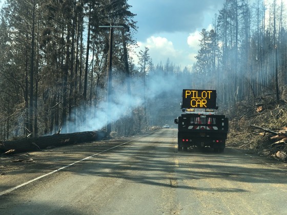
GLIDE – Oregon 138E (North Umpqua Highway) is set to reopen at noon on Tuesday, Sept. 22. The highway has been closed two weeks due to the Archie Creek and Thielsen fires.
For the next few weeks, the highway will be reduced to a single lane in some areas between Swiftwater Park and the Oregon 230 junction (milepost 23-83). This will allow workers to remove hazards, address fire damage and assist in firefighting operations.
Pilot cars and flaggers will provide 24-hour traffic control at each location. Motorists traveling the length of the corridor can expect delays up to 45 minutes.
Visibility conditions may change quickly and many roadside hazards persist. Motorists are advised to drive with caution at a speed that is appropriate for road conditions.
Because of these potential hazards, motorists are requested to stay in their vehicles and avoid pulling over and stopping.
Despite the highway reopening, the Umpqua National Forest and BLM managed lands, including all recreational areas between Glide and Diamond Lake, remain closed to the public.
ODOT and partner agencies will need months to address the damage from the two fires. An estimated 7,000 to 10,000 hazard trees will need to be removed. The fire destroyed 100 of 255 road signs, damaged 5½ miles of guardrail, and affected more than 100 slopes, increasing the potential for rock slides over the winter.
Damaged treesSome motorists driving through the corridor will see large trees and wonder why they are being cut down. We understand these concerns and want to leave as many trees standing as possible, but thousands of trees, many that look healthy, pose a risk to the traveling public.
In some cases, dead trees do not turn brown right away. Trees that look undamaged from the road can be heavily burned on the far side. Fires sometimes burn the root structure and weaken a tree even though the trunk looks undamaged.
For more information, contact ODOT Public Information Officer Dan Latham at 541-817-5200 or Dan.Latham@odot.state.or.us.
Archie Creek Fire update Monday Sept 21 2020
Related Incident:
Publication Type: News
Archie Creek Fire Update September 21, 2020
Unified Incident Commanders Mike Dueitt and Tim Keith
Email: 2020.archiecreek@firenet.gov
Phone: 971-334-7674 Hours: 8am-8pm
InciWeb: https://inciweb.nwcg.gov/incident/7176/
Facebook: https://www.facebook.com/ArchieCreekFireInfo/
Special Note: A combination of recent rainfall, cooler temperatures and more favorable fire conditions have allowed the Douglas Forest Protective Association to lower fire restrictions for the general public and industrial operators. Effective today, all DFPA protected lands have a fire danger rating of moderate and Industrial Fire Precaution Level II. A detailed list of Public Use Restrictions can be found at www.dfpa.net/public-fire-restrictions.
The Umpqua National Forest has lowered the Industrial Fire Precaution Level to Level III and the Fire Adjective Class from High from Extreme. For more information see https://inciweb.nwcg.gov/incident/article/7176/56514/
Fire Update: The Archie Creek Fire has burned 131,598 acres and is 41 percent contained. There are currently 1,121 personnel assigned to the fire.
A low inversion over the fire yesterday morning helped keep fire behavior to smoldering, creeping and backing. Because of this, firefighters continued to make good progress building and strengthening firelines and mopping up. A forecasted frontal system arriving Wednesday is expected to drop another half inch of rain on the fire by the weekend, which will further aid containment. However, “It ain’t over till it’s over,” said Operations Chief Mark Jamieson, quoting baseball legend Yogi Berra. An infrared flight Friday showed many sources of heat scattered throughout the fire, some of them near containment lines. Yesterday firefighters flying over the fire discovered a new start outside the perimeter of the Archie Fire, about two miles north of its northeast flank in the Pass Creek area. The fire probably was caused from a lightning strike from a recent thunderstorm and flared up when conditions became warmer and drier. Crews from the Archie Fire responded and will continue to work on the holdover fire today. Helicopters are ready to make water drops if necessary.
Firefighters will focus on cooling hot spots and continuing to build, connect and strengthen firelines. Specific areas of concern are on the south, east and northern edges of the fire. In the south, this includes areas around Little River and Thunder Mountain roads to Highway 138. Firefighters are assessing the area west of Thunder Mountain for retardant drops by helicopter and may make drops today, if needed. In the east, containment and mop up continues in three areas where the fire burned over containment lines in the Panther Creek (4714) Road area west of Highway 138. Yesterday hand crews made good progress there constructing firelines directly at the fire’s edge. Along the northeastern edge of the fire, mop up will continue along firelines and firefighters will begin to assess what actions are needed to repair areas damaged by building firelines.
Fire hose placed all around the fire helps cool areas near containment lines. Hand crews continue to arrive to finish building, fortifying and mopping up firelines. The fire has backed down to the North Umpqua River on the east flank and firefighters are monitoring it there. Fire scars are helping check fire progression in the southeastern edge of the fire and firefighters are using old timber sale roads (600 series) to contain the fire in that area.
Mop up continues around structures in Glide, Idleyld Park and Rock Creek and firefighters are protecting homes and other buildings from fire in all areas of the fire, including along Little River Road. They are assessing structure protection for the Bar L subdivision. Firefighters will work into the night to ensure structures are safe. Other areas of special protection include the Wolf Creek Job Corps, Susan Creek Bridge, communications equipment on Scott Mountain and the Big Tree area. The Big Tree is still standing and the area around it was not affected by the fire. Firefighters will continue to remove live and dead vegetation around the Job Corps to reduce fire risk.
North of Highway 138E, in the Steamboat area, firefighters and heavy equipment continue to work along Canton Creek Road to Trapper Creek to improve contingency firelines in case the fire crosses primary firelines.
Personnel and Equipment: 22 Type 2 hand crews, 6 helicopters, 1 fixed wing air attack platform, 61 engines, 49 bulldozers, 48 water tenders, 9 masticators and 6 skidgeons.
Help for Fire Victims: The following agencies and organizations are helping those who were affected by this fire and are accepting donations.
Glide Revitalization Committee: https://gliderevitalization.com/
Glide Helping Hands: 541-733-6860
Glide Baptist Church: https://www.glidebaptist.org/
Greater Douglas United Way: https://gduway.org/campaigns/fire-relief-fund/
Roseburg Rotary: https://www.facebook.com/RoseburgRotary/ and
https://www.paypal.com/cgi-bin/webscr?cmd=s-xclick&hosted_button_id=3D2BEGT2AJBRS&source=url
Douglas Timber Operators / Umpqua Fisheries Enhancement Derby:
Saving Grace: www.savinggrace.info 541-672-3907
Red Cross: Located at the Douglas County Fairgrounds. Check for current needs.
Oregon Department of Human Services: Check for current needs. Food items will not be accepted. Donations can be dropped off this week at the Roseburg Department of Human Services building at 738 W Harvard, Roseburg OR M-F, 9am-4pm through 9/18/20
Evacuations, shelter areas: An interactive map of the current evacuation area can be found at www.dcso.com/evacuations. For more evacuation information, visit the Douglas County Sheriff website www.dcso.com/evacuations and Facebook page at https://www.facebook.com/DouglasCoSO
The Red Cross has services and a shelter at the Douglas County Fairgrounds. Call 541-672-6581 The Western Oregon Expo Fairgrounds in Cottage Grove has space for evacuees, livestock and tents. Contact Skye Hefner at 541-556-2727 for more information.
Air quality: See the Oregon Department of Environmental Quality at http://www.oregon.gov/deq
Closures:
Roads – Highway 138E remains closed to all traffic except for firefighters and residents from Milepost 21 through Milepost 83. See www.tripcheck.com for updates on highway closures.
Bureau of Land Management – All lands east of Interstate 5, within the Swiftwater Resource Area are closed.
Umpqua National Forest – Maps and closure orders can be found on Inciweb at: https://inciweb.nwcg.gov/incident/closures/7176/ . Additional information on the Forest Service closures are available at: https://www.fs.usda.gov/alerts/umpqua/alerts-notices Managed lands east of Interstate 5, within the Swiftwater Resource Area are closed.
Temporary Flight Restriction: There is a temporary flight restriction in effect for the Archie Creek Fire.
DFPA Fire Restrictions Lowered Fire Season Remains in Effect
Related Incident:
Publication Type: Announcement

A combination of recent rainfall, cooler temperatures and more favorable fire conditions have allowed the Douglas Forest Protective Association to lower fire restrictions that are in place for both the general public and industrial operators. Effective Monday, September 21st at 12:01 AM, all DFPA protected lands will move to a fire danger rating of MODERATE and Industrial Fire Precaution Level 2.
For the general public, a moderate fire danger rating changes the shutdown times for several activities listed in DFPA’s Public Use Restrictions. During moderate fire danger, the following activities are prohibited between the hours of 1:00 PM and 8:00 PM:
• The cutting, trimming or mowing of dead grass. This restriction does not apply to the mowing of green lawns or for the commercial culture and harvest of agricultural crops.
• The cutting, grinding or welding of metal for non-industrial purposes.
• The use of power saws for non-industrial purposes.
• Any non-industrial improvement or development taking place on private property that utilizes power driven machinery not specifically mentioned in the Public Use Restrictions.
Fire officials remind that all other restrictions listed in DFPA’s Public Use Restrictions remain in effect and are unchanged. Backyard debris burning also remains prohibited. A detailed list of Public Use Restrictions can be found at www.dfpa.net/public-fire-restrictions
For industrial operators and other industrial forest workers who are operating on forestlands, IFPL II prohibits the following industrial activities between the hours of 1:00 PM and 8:00 PM:
• The use of power saws, except at loading sites.
• Feller-bunchers with rotary head saws.
• Cable Yarding
• Blasting
• Cutting, grinding, or welding of metal.
In addition, a fire watch of at least two hours is required during IFPL II, once work has completed for the day. Some private landowners or public land management agencies may require a longer fire watch on the lands they own or manage.
For more information about public or industrial fire restrictions within the Douglas District, visit www.dfpa.net or call 541-672-6507.
Umpqua National Forest Industrial Fire Precaution Lowers to Level III
Related Incident:
Publication Type: Announcement
Due to a decrease in fire danger levels, primarily because of recent rains and higher nighttime humidity recoveries, the Umpqua National Forest will lower the Industrial Fire Precaution Level to Level III effective 12:01 a.m., Monday, Sept. 21, 2020. No industrial operating waivers will be issued. The Fire Adjective Class will also be lowered to High from Extreme.
The Forest remains closed to the public and hunting due to ongoing firefighting operations. Under IFPL III, also called partial shutdown, industrial operators are prohibited from performing the following:
- Fire Wood Cutting – All firewood cutting on the Umpqua National Forest is prohibited.
- Cable Yarding – except that gravity operated logging systems with non-motorized carriages may operate between 8 p.m. and 1 p.m. when all blocks and moving lines are suspended 10 feet above ground except the line between the carriage and the chokers;
- Power Saws – except at loading sites and at tractor skidder operations between 8 p.m. and 1 p.m.
- Tractor, skidder, feller-buncher, forwarder, or shovel logging operations where tractors, skidders, or other equipment with a blade capable of constructing fire line are immediately available to quickly reach and effectively attack a fire start; mechanized loading or hauling of any product or material; blasting; welding or cutting of metal; any other spark emitting operations not specifically mentioned.
The Umpqua National Forest remains under Level 2 Public Use Restrictions. For more information about the Umpqua National Forest call the Forest at (541) 957-3200 or www.fs.usda.gov/umpqua.