
Inchelium Complex Update Sept 20 2020
Related Incident:
Publication Type: News
Two fires currently burning in a mix of timber and brush on the Colville Indian Reservation and one in patrol status comprise the Inchelium Complex: Inchelium Highway Fire, Kewa Fields Fire, and Fry Fire. All three fires are being managed for full suppression. Crews remain focused on securing exterior lines with an emphasis on mopping up around structures, and the ongoing protection of natural and cultural resources.
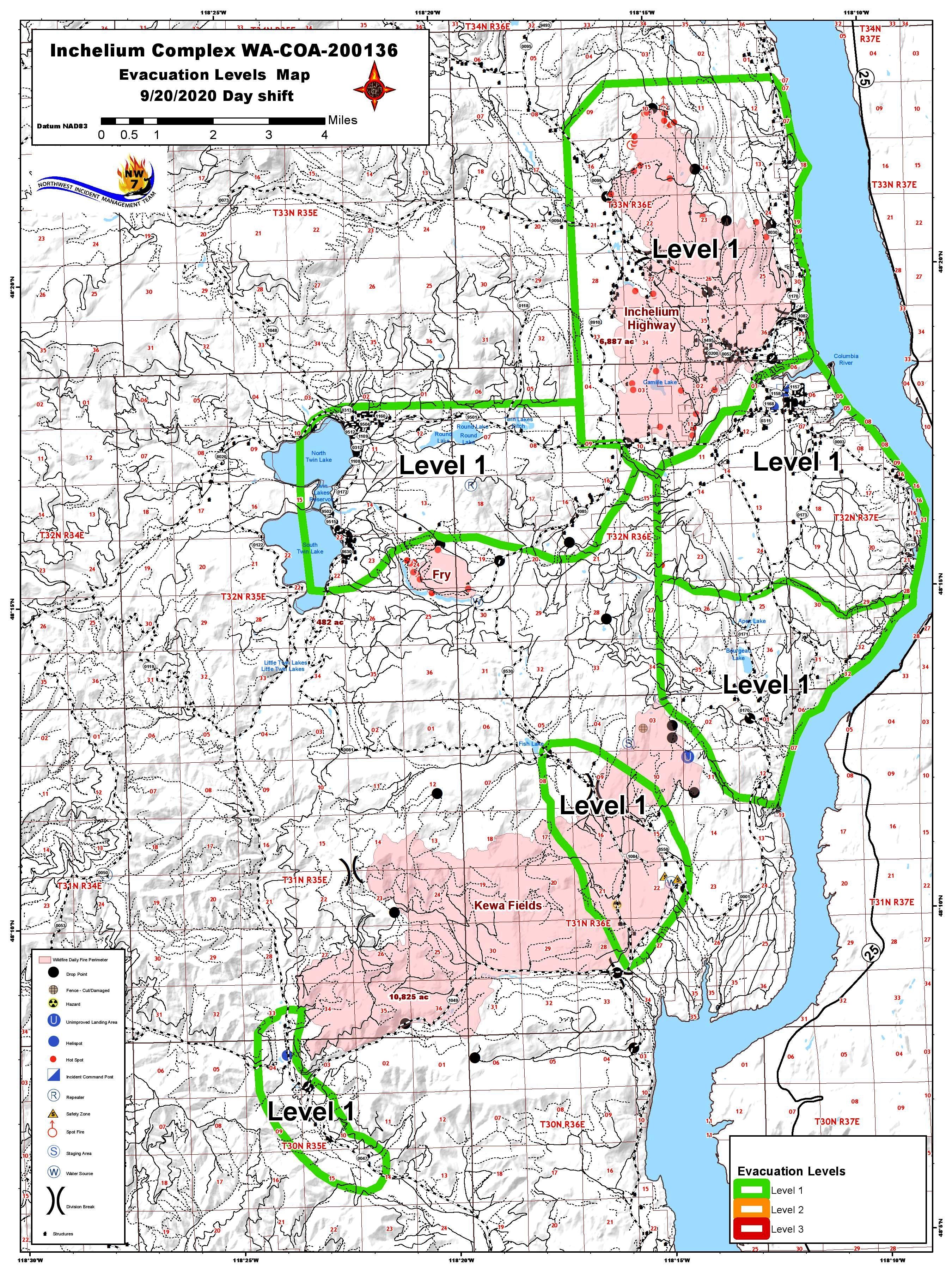
All Level 2 Evacuations around the Inchelium Complex fires were reduced to Level 1 Evacuations effective 6PM Saturday, Sept. 19, 2020.
Current Situation: Showers have passed and were mostly hit and miss. Both the Inchelium Highway Fire and Fry Fire received some rainfall but our most active fire, Kewa Fields Fire, was missed by the passing front. On Inchelium Highway Fire yesterday, firefighters mopped up along the fire lines to gain more depth in the northwest flank. Crews also continued mopping up around structures inside the perimeter and other flanks. On the Kewa Fields Fire, crews continued to mop up along fire lines in the northeast corner, and secure and hold containment lines on east and south flanks. Crews continued to work to improve the west and north flanks. The Fry Fire continued to be secure.
Today’s Operations: Inchelium Highway Fire (7,120 acres): Mopping up on all flanks and around structures will continue. Equipment will be moving into the area to begin suppression repair work on the Inchelium Highway Fire. Crews working with hand tools and heavy machinery will repair damages and minimize potential soil erosion and other impacts resulting from fire suppression activities.
Kewa Fields Fire (11,797 acres): Crews will continue to mop up fire lines on the northeast flank and better secure the east and south flanks. Additional burnout operations are planned on the north and west flanks. Looking for options to secure the fire closer to the burning perimeter of the north flank remains a priority.
Fry Fire (482 acres): Firefighters will patrol and monitor the Fry Fire and continue with suppression repair efforts.
Weather and Fire Behavior: The forecast calls for temperatures in the upper 60s and relative humidity with light winds. Forest fuels under the canopy is remains dry in most places. Expect creeping and isolated flare-ups especially in areas missed by the recent rain event and in areas with heavy fuel loading under a closed canopy.
Smoke: Air quality has improved significantly and there will be clear skies above the fire.
Road Closures: Seylor Valley Road north of Bridge Creek and Hall Creek Roads are closed. Bridge Creek Road is open.
Evacuation Levels: For the latest evacuation information see updates from Colville Tribal Emergency Operations https://www.colvilletribes.com/active-fires.
COVID-19: Mitigations are being taken to limit exposure risks to firefighters and the Tribal community per CDC guidelines.
Level 2 Evacuations at Inchelium Complex Reduced to Level 1 Sept 19 2020
Related Incident:
Publication Type: Announcement
All Level 2 Evacuations around the Inchelium Complex fires were reduced to Level 1 Evacuations effective 6PM Saturday, Sept. 19.
Inchelium Complex Update Sept 19 2020
Related Incident:
Publication Type: News
Two fires currently burning in a mix of timber and brush on the Colville Indian Reservation and one in patrol status comprise the Inchelium Complex: Inchelium Highway Fire, Kewa Fields Fire, and Fry Fire. All three fires are being managed for full suppression. Crews remain focused on securing exterior lines with an emphasis on mopping up around structures, and the ongoing protection of natural and cultural resources.
Current Situation: Yesterday on the Inchelium Highway Fire, crews continued to find and extinguish hot spots near containment lines in the northwest flank, with aggressive mop up pushing deeper into burned areas along all flanks. On the Kewa Fields Fire work advanced to improve and secure the northeast, east, and south flanks. Burnout operations were conducted along the west flank, and firefighters were able to construct containment line closer to the burning perimeter of the north flank. Suppression repair began at the Fry Fire with repairs to dozer line along the southeast perimeter.
Today’s Operations: A suppression repair group has been formed to repair areas disturbed in the building of hand and dozer containment lines, along with roads, trails, staging areas, safety zones and drop points used during fire suppression efforts.
Inchelium Highway Fire (7,120 acres): Equipment and crews will focus on mopping up to secure the northwest flank, particularly around structures within the fire’s perimeter. Firefighters will use heat sensing equipment, known as Infrared Scanners, to detect heat sources. A Level 2 evacuation is in effect for residents near Hall Creek Road and Seylor Valley Road.
Kewa Fields Fire (11,797 acres): Crews will continue to mop up fire lines on the northeast flank, and secure and mop up fire lines on the east and south flanks. Additional burnout operations are planned on the north and west flanks. A Level 2 Evacuation remains in effect in the vicinity of the southwest flank of Kewa Fields Fire in the proximity of Wilmont Creek Road, and the area extending two miles north of Stray Dog Canyon, and within Stray Dog Canyon.
Fry Fire (482 acres): Firefighters will patrol and mop up isolated pockets of heat. A Level 1 evacuation is in effect for residents living near Twin Lakes and Meteor Road including North and South Twin.
Weather and Fire Behavior: Temperatures are expected to be in the upper 60s, with minimum relative humilities around 50%, and light southwest winds of 3-6 mph. There remains a chance for isolated storms with accompanying winds gusts up to 15 - 25 mph. Although slightly hampered by the moderating conditions, active fire behavior including backing and flanking fire spread is expected.
Smoke: Smoke will likely continue to create reduced air quality throughout the day. By Sunday morning air quality should be Good to Moderate, except in areas very close to the fires.
Road Closures: Seylor Valley Road north of Bridge Creek and Hall Creek Roads are closed. Bridge Creek Road is open.
Evacuation Levels: For the latest evacuation information see updates from Colville Tribal Emergency Operations https://www.colvilletribes.com/active-fires.
COVID-19: Mitigations are being taken to limit exposure risks to firefighters and the Tribal community per CDC guidelines.
Inchelium Complex Update Sept 18 2020
Related Incident:
Publication Type: News
Fire managers are developing a suppression repair plan. The plan will identify actions to repair post-fire damages and minimize potential impacts such as soil erosion resulting from suppression activities.
Current Situation: On the Inchelium Highway Fire crews continued to mop up and reinforce fire lines along the northwest flank. Firefighters, aided by National Guard forces, began walking a grid pattern looking for hot spots near private structures within the fire’s perimeter. On the Kewa Fields Fire crews continued to mop up and secure fire lines on the northwest and east flanks. A small slopover that occurred on the south flank was suppressed with the aid of helicopter bucket work. Efforts to reinforce fire lines on the north flank continued with crews scouting for more locations to build direct line. The Fry Fire continued to be secure.
Today’s Operations: Inchelium Highway Fire (7,120 acres): Locating and suppressing hot spots around structures continues to be a primary mission, along with continuing to hold and secure fire lines. A Level 2 evacuation is in effect for residents near Hall Creek Road and Seylor Valley Road.
Kewa Fields Fire (11,403 acres): Crews will continue to improve and secure the northeast, east, and south flanks, and mop up the recent slopover in the south flank. Burnout operations are being utilized to remove unburned forest fuels between the burning edge of the fire and indirect fire lines on the south and north flanks. Firefighters will continue to look for opportunities to build direct line along the fire’s edge on the northern flank. A Level 2 Evacuation remains in effect in the vicinity of the southwest flank of Kewa Fields Fire in the proximity of Wilmont Creek Road, and the area extending two miles north of Stray Dog Canyon, and within Stray Dog Canyon.
Fry Fire (482 acres): The Fry Fire will be in a full patrol status today. A Level 1 evacuation is in effect for residents living near Twin Lakes and Meteor Road including North and South Twin.
Weather and Fire Behavior: A low pressure system will continue to move into the area today bringing increased precipitation through Saturday. Until then, fire managers expect active fire behavior with backing fire spread within control lines on Kewa Fields Fire, and smoldering within control lines on the Inchelium Highway and Fry Fires.
Smoke: Expect smoke and haze to continue into Saturday morning. The air quality in the region is still rated unhealthy. The advice from experts: Stay inside and breathe as little of that outside air as possible. By Sunday morning air quality should be Good to Moderate, except very close to fires.
Road Closures: The Seylor Valley Road north of Bridge Creek and Hall Creek Roads are closed. Bridge Creek Road is open.
Evacuation Levels: For the latest evacuation information see updates from Colville Tribal Emergency Operations https://www.colvilletribes.com/active-fires.
COVID-19: Mitigations are being taken to limit exposure risks to firefighters and the Tribal community per CDC guidelines.
Inchelium Complex Update Sept 17 2020
Related Incident:
Publication Type: News
Three National Guard units arrived yesterday including the 141th Air Refueling Wing (Air Guard), 420th Chemical Battalion (Army Guard), and 194th Air Refueling Wing (Air Guard).
Current Situation: On Inchelium Highway Fire, firefighters aggressively reinforced containment lines around the entire north flank. National Guard units worked around residences inside the fire perimeter to better secure the area. On
Kewa Fields Fire crews continued securing fire lines on the northeast, east, and southern flanks. In the northwest flank, a combination of dozer lines and existing roads have been completed and tied together. A combination of direct and indirect containment lines now encircle the fire. Containment lines at the Fry Fire continued to be secure.
Kewa Fields Fire (11,376 acres): Securing and improving fire lines on the northeast, east, and south flanks will remain a focus today. Mop up continues along direct fire line constructed around the slopover across Cougar Canyon Road. Firefighters will also continue to scout for opportunities to build direct line along the fire’s edge on the northern flank. A Level 2 Evacuation remains in effect in the vicinity of the southwest flank of Kewa Fields Fire in the proximity of Wilmont Creek Road, and the area extending two miles north of Stray Dog Canyon, and within Stray Dog Canyon.
Fry Fire (482 acres): Hand crews will continue to better secure the Fry Fire, which remains mostly in patrol status. A Level 1 evacuation is in effect for residents living near Twin Lakes and Meteor Road including North and South Twin.
Weather and Fire Behavior: Today’s weather will be similar to yesterday with temperatures in the upper 70s, relative humidity in the low 20s on ridges, and even lower in the valleys, and light winds out of the northeast. Some rainfall is anticipated this weekend. Fire behavior should remain active with fire backing down and burning across slopes.
Smoke: Smoke will likely remain heavy until the weather changes this weekend. Air quality remains unhealthy for much of the local area.
Road Closures: The Seylor Valley Road north of Bridge Creek and Hall Creek Roads are closed. Bridge Creek Road is open.
Evacuation Levels: For the latest evacuation information see updates from Colville Tribal Emergency Operations https://www.colvilletribes.com/active-fires.
COVID-19: Mitigations are being taken to limit exposure risks to firefighters and the Tribal community per CDC guidelines.
Inchelium Complex Update Sept 16 2020
Related Incident:
Publication Type: News
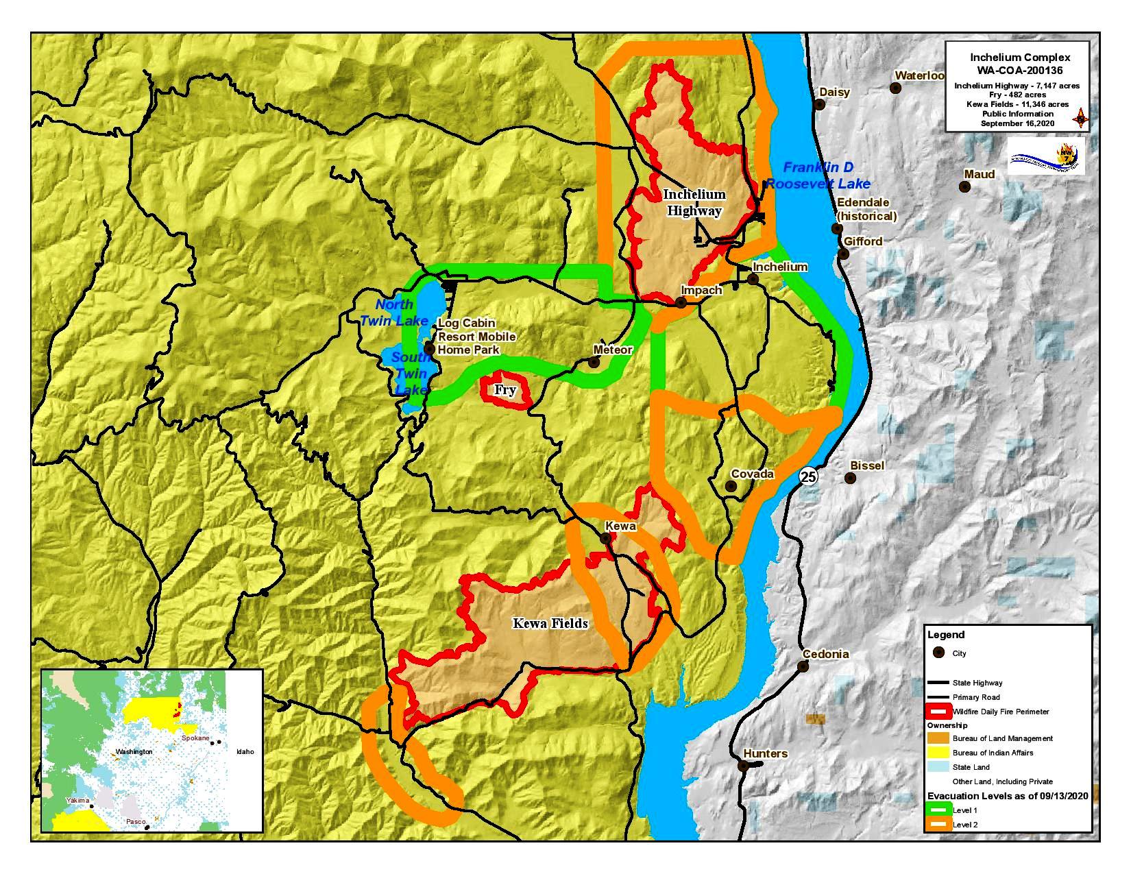
Today’s Operations: Inchelium Highway Fire (7,147 acres): Firefighters will continue to strengthen and secure containment lines along the north flank. Crews are beginning to collect data where fire lines were constructed to help determine future suppression repair needs. Mopping up around residences and other structures continues. A Level 2 evacuation is in effect for residents near Hall Creek Road and Seyler Valley Road.
Kewa Fields Fire (11,346 acres): Improving and securing existing fire lines remains a priority along the fire’s perimeter northwest, east, and Cougar Canyon Road. Crews will work to hold newly constructed line built directly around the slopover in the southwest flank. On the west flank and moving down from the north end, firefighters are building fire lines and connecting road systems that they intend to use for suppression efforts. Resources are shifting from secured areas to assist with this effort. A Level 2 Evacuation remains in effect in the vicinity of the southwest flank of Kewa Fields Fire in the proximity of Wilmont Creek Road, and the area extending two miles north of Stray Dog Canyon, and within Stray Dog Canyon.
Fry Fire (482 acres): The Fry Fire is in patrol status. A Level 1 evacuation is in effect for residents living near Twin Lakes and Meteor Road including North and South Twin.
Smoke: Smoke is expected to remain heavy throughout the area for the next several days. Substantial clearing won’t likely occur until Friday or Saturday.
Evacuation Levels: For the latest evacuation information see updates from Colville Tribal Emergency Operations https://www.colvilletribes.com/active-fires.
Inchelium Complex Update Sept 15 2020
Related Incident:
Publication Type: News
Three fires currently burning in a mix of timber and brush on the Colville Indian Reservation comprise the Inchelium Complex: the Fry Fire, Inchelium Highway Fire, and Kewa Fields Fire. All three fires are being managed for full suppression. The cause of the fires remains under investigation. Crews remain focused on point protection with an emphasis on structures and natural and cultural resources, and minimizing the footprint on all three fires.
Today’s Operations:
Inchelium Highway Fire (7,147 acres): Crews will continue to mop up and strengthen control lines around structures within the perimeter and improve fire lines on all flanks. A Level 2 evacuation is in effect for residents near Hall Creek Road and Seyler Valley Road.
Fry Fire (482 acres): Some mop up work remains to be done in the drainage to completely secure and contain the fire. A Level 2 evacuation is in effect for residents living near Twin Lakes and Meteor Road including North and South Twin.
Public Notice Air Quality Warning
Related Incident:
Publication Type: Announcement
CONFEDERATED TRIBES OF THE COLVILLE RESERVATION OFFICE OF ENVIRONMENTAL TRUST
Public Notice - Air Quality Warning
Extended to Friday 9-18-2020
Date: September 14, 2020
We will continue to experience air quality in the Unhealthy to Hazardous conditions through Friday with some improvement over the weekend. Firefighters are gaining control on the Reservation fires with little increase in acreages and new smoke production.
These fires will continue to smolder or flare up inside the containment lines so expect some smoke. Fires in Oregon and California will continue to keep our area smoke filled as the current weather pattern pushes smoke over Eastern Washington.
Inchelium Complex Update Sept 14 2020
Related Incident:
Publication Type: News
Three fires actively burning in a mix of timber and brush on the Colville Indian Reservation comprise the Inchelium Complex: the Fry Fire, Inchelium Highway Fire, and Kewa Fields Fire. All three fires are being managed for full suppression. The cause of the fires remains under investigation. Crews remain focused on point protection with an emphasis on structures and natural and cultural resources, and minimizing the footprint on all three fires.
A virtual community meeting was held yesterday to provide an overview of the fires and answer questions. A recording of it can be viewed at: www.facebook.com/ColvilleTribune, www.facebook.com/CCTBroadcasts
Today’s Operations: Inchelium Highway Fire (7,147 acres): Work will continue to advance and reinforce containment lines on the northwest flank, and scout for any additional hold-over spot fires. Securing fire lines around the structures within the fire perimeter in the southern portion remains a priority. Crews will hold and secure fire lines on other flanks as they mop up further into burned areas. A Level 2 evacuation is in effect for residents near Hall Creek Road and Seyler Valley Road.
Kewa Fields Fire (11,311 acres): Hand crews will continue to mop up and improve containment line around the flank overlooking the Stray Dog Canyon. Preparations continue on the indirect contingency line at Coyote Creek while firefighters scout for opportunities to go more direct along the fire’s edge near Cougar Canyon. With improving conditions and additional resources, firefighters will also be scouting the west flank and northwest flanks. A Level 2 Evacuation remains in effect in the vicinity of the southwest flank of Kewa Fields Fire in the proximity of Wilmont Creek Road, and is now also in effect for the area extending two miles north of Stray Dog Canyon, and within Stray Dog Canyon.
Fry Fire (482 acres): Firefighters will continue to mop up along the west flank. The rest of the fire is now in a monitor and patrol status. A Level 2 evacuation remains in effect for residents living near Twin Lakes and Meteor Road including North and South Twin.
Weather and Fire Behavior: A weak frontal system will move into the area today and overnight that could produce some light rain, especially overnight. Temperatures are expected to be in the high 60s or low 70s with a dramatic increase in relative humidity. The forecast calls for similar weather over the next several days. Spread rates and fire behavior will be limited with little to no spotting potential.
COVID-19: Mitigations are being taken to limit exposure risks to firefighters and the Tribal community per CDC guidelines.
The Level 3 Evacuation Around Stray Dog Canyon Reduced to a Level 2
Related Incident:
Publication Type: Announcement
The Level 3 Evacuation Around Stray Dog Canyon Reduced to a Level 2