
Ether Hollow Fire Update Sept 16 2020
Related Incident:
Publication Type: News
September 16, 2020 at 10:00 a.m.
Location: East of Springville, UT
Email: 2020.William@firenet.gov
Start Date: September 7, 2020
Phone: 1-435-414-9418
Cause: Human caused, target shooting
Acres: 849
Percent Contained: 86%
Personnel Assigned: 28
Containment percentages on the Ether Hollow Fire will reflect the two strategies of Full Suppression and Confine Strategy. The areas where firefighters can safely access and build fireline have been contained and reflect 86% of the fire perimeter. That portion of the fire is 100% contained. Crews are working on the remaining 14% of the fire area where the Confine Strategy is being used to find where firelines and natural barriers that can be used to suppress the fire.
Current Status: Today firefighters will scout areas along Grindstone Ridge for potential contingency lines. This is part of a Strategic Plan looking at tactical options on parts of the fire that are inaccessible by foot and unsafe for firefighters due to extreme terrain. Helicopters are still available to suppress areas where fire is still active in inaccessible locations.
Suppression repair work continues on sections of dozer line that are no longer needed. This work includes leveling the berm on the side of the dozer line to return the area disturbed by the dozer to a more natural state.
Whiting Campground, Maple Canyon trail #006 and Right Fork trail #007 remain closed. We ask that the public stay away from the fire area for the safety of the firefighters and the public. https://www.fs.usda.gov/uwcnf
Hunters with limited entry Bull Elk tags and archers, please check your hunting unit and be sure to stay out of the closed areas. We aim to keep our firefighters and public safe, your aim will help.
Weather: Today will be sunny, warmer and drier with temperatures predicted near 90. Humidity will be low and winds will be terrain driven gusting 9 to 12 mph. Strong southwest winds are expected late in the week ahead of a dry cold front.
Fire behavior is expected to be minimal with light winds producing interior smoldering and some visible smoke.
There is a fuel and fire behavior advisory in effect for critically dry fuels through September 25th, 2020.
A TFR (Temporary Flight Restriction) has been implemented over the fire area – which means recreational drones and private aircraft cannot fly over the fire. The TFR can be found here: https://tfr.faa.gov/save_pages/detail_0_6165.html.
Please remember, if you fly, we can’t.
Fire information can be found on InciWeb at or https://utahfireinfo.gov/. Check out News & Events and ‘Like Us’ on facebook.com/UtahWildfire , and ‘Follow Us’ on twitter.com/UtahWildfire for further information.
Ether Hollow Fire update Sept 15 2020
Related Incident:
Publication Type: News
September 15, 2020 at 10:00 a.m.
Location: East of Springville, UT
Email: 2020.William@firenet.gov
Phone: 1-435-414-9418
Start Date: September 7, 2020
Cause: Human caused, target shooting
Acres: 849
Percent Contained: 86%
Personnel Assigned: 35
As Great Basin Incident Management Team 3 continues to fight the Ether Hollow Fire, two fire suppression strategies are being implemented. The first approach is Full Suppression, and the remaining portion of the fire has been identified for a Confine Strategy. This area is southwest of the Hobble Creek Golf Course on the northeast side of Ether Peak. The dual approach will meet the objective of 100% full perimeter containment where fuels and terrain are favorable for successful suppression and provide for firefighter safety.
Confine Strategy, as defined by the National Wildfire Coordinating Group (NWCG), “is to restrict a wildfire to a defined area, using a combination of natural and constructed barriers that will stop the spread of the fire under the prevailing and forecasted weather conditions until out.” Helicopter bucket drops will be used as an action to suppress the Confine portions of the fire perimeter that firefighters cannot access.
The unified decision to implement the Confine Strategy was made in coordination with the State of Utah Department of Natural Resources, the USDA Forest Service, and fire officials in Utah County. The decision-makers have evaluated and considered the hazardous terrain and the inability for firefighters to suppress the fire safely in the Ether Peak area.
Firefighters continue to identify and implement control lines in strategic locations that will insure the highest percent of success of a 100% full perimeter containment and firefighter safety. Firefighters are implementing actions that protect local, state, and federal lands and utilities in the event the fire advances beyond its current location.
Current Status: Today crews will continue work to gain more containment on the northeast portion of the fire.
Whiting Campground, Maple Canyon trail #006 and Right Fork trail #007 remain closed. We ask that the public stay away from the fire area for the safety of the firefighters and the public. https://www.fs.usda.gov/uwcnf
Hunters with limited entry Bull Elk tags and archers, please check your hunting unit and be sure to stay out of the closed areas. We aim to keep our firefighters and public safe, your aim will help.
Weather: There is a red flag warning in effect. The next few days will trend warmer and drier with temperatures forecast in the upper 80s with gusting terrain driven winds 10-15 mph.
Fire behavior today is expected to be minimal with possible pockets of interior torching, smoldering and surface creeping. More smoke may be visible as sun and wind warm and dry fuels available in the fire area.
There is a fuel and fire behavior advisory in effect for critically dry fuels through September 25th, 2020.
A TFR (Temporary Flight Restriction) has been implemented over the fire area – which means recreational drones and private aircraft cannot fly over the fire. The TFR can be found here: https://tfr.faa.gov/save_pages/detail_0_6165.html. Please remember, if you fly, we can’t.
Fire information can be found on InciWeb at or https://utahfireinfo.gov/. Check out News & Events and ‘Like Us’ on facebook.com/UtahWildfire , and ‘Follow Us’ on twitter.com/UtahWildfire for further information.
Ether Hollow Fire Update Sept 14 2020
Related Incident:
Publication Type: News
September 14, 2020 at 10:00 a.m.
Location: East of Springville, UT
Email: 2020.William@firenet.gov
Start Date: September 7, 2020
Phone: 1-435-414-9418
Cause: Human caused, target shooting
Acres: 849
Percent Contained: 65%
Personnel Assigned: 67
Flight incursions from aircraft and drones force fire air resources to land, delaying critical support to firefighters on the ground. If you are a pilot, you must check NOTAMs before finalizing your flight plan.
There have been multiple fixed wing and drone incursions on fires in the past few days, putting all involved at risk.
A TFR (Temporary Flight Restriction) has been implemented over the fire area – which means recreational drones and private aircraft cannot fly over the fire. The TFR can be found here: https://tfr.faa.gov/save_pages/detail_0_6165.html. Please remember, if you fly, we can’t.
Current Status: Today, crews will mop up further interior, working from West to East, with a goal of moving 100 feet in from the line. Firefighters continue to identify and implement control actions in the event the fire moves beyond the uncontained perimeter. Alternate suppression tactics are being initiated in the steep, inaccessible terrain to ensure firefighter safety.
The contingency line and hose lay are complete along the Hobble Creek Canyon road. This fireline will only be used to stop the fire’s progression if fire activity increases towards the north and threatens communities in that area.
Suppression repair work on sections of dozer line that is no longer needed begins today in coordination with local agencies impacted by the fire.
With shared air resources between three fires, the Air Branch Director will prioritize the most critical missions for three helicopters throughout the day.
Whiting Campground, Maple Canyon trail #006 and Right Fork trail #007 remain closed. We ask that the public stay away from the fire area for the safety of the firefighters and the public. https://www.fs.usda.gov/uwcnf
Hunters with limited entry Bull Elk tags and archers, please check your hunting unit and be sure to stay out of the closed areas. We aim to keep our firefighters and public safe, your aim will help.
Weather: There is a red flag warning in effect. The next few days will trend warmer and drier with temperatures forecast in the mid-80s with gusting terrain driven winds 10-15 mph. Fire behaviortoday is expected to be minimal with possible pockets of interior torching, smoldering and surface creeping. More smoke may be visible as sun and wind warm and dry fuels available in the fire area.
There is a fuel and fire behavior advisory in effect for critically dry fuels through September 25th, 2020.
Fire information can be found on InciWeb at or https://utahfireinfo.gov/. Check out News & Events and ‘Like Us’ on facebook.com/UtahWildfire , and ‘Follow Us’ on twitter.com/UtahWildfire for further informationEther Hollow Fire Update Sept 13 2020
Related Incident:
Publication Type: News
Email: 2020.William@firenet.gov
Phone: 1-435-414-9418
Acres: 849
Personnel Assigned: 80
Temporary Road Campground Closure Maple Canyon Ether Hollow Fire
Related Incident:
Publication Type: Closures
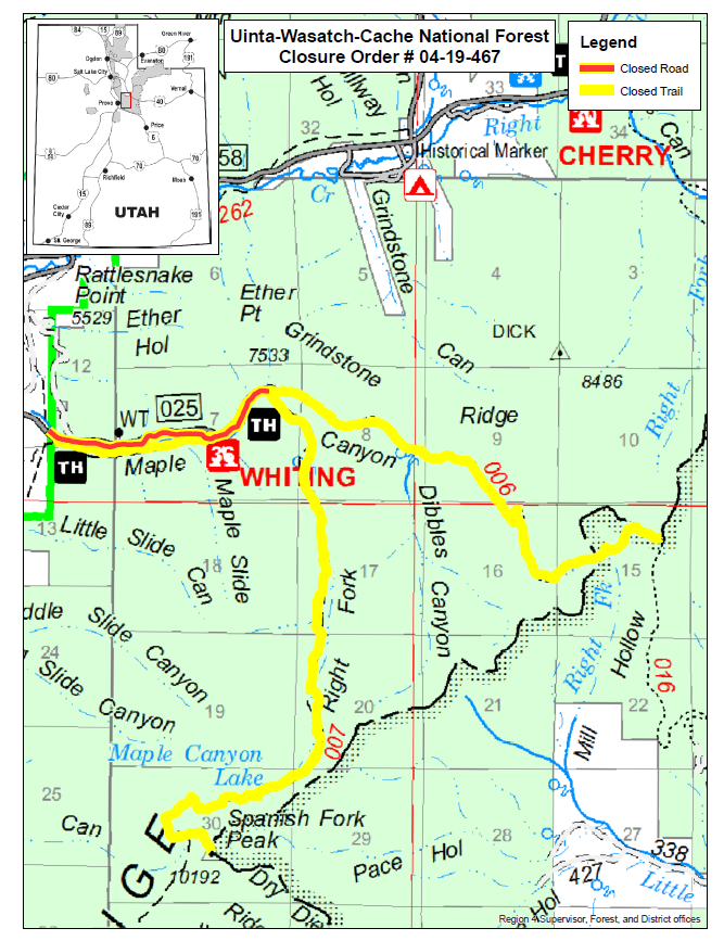
Order No 04-19-467 UNITED STATES DEPARTMENT OF AGRICULTURE FOREST SERVICE 857 WEST SOUTH JORDAN PARKWAY SOUTH JORDAN, UTAH 84095 SPECIAL ORDER OF FOREST SUPERVISOR UINTA-WASATCH-CACHE NATIONAL FOREST SPANISH FORK RANGER DISTRICT TEMPORARY ROAD, CAMPGROUND AND TRAIL CLOSURES PROHIBITION: Pursuant to 36 CFR 261.50(a) and 36 CFR 261.50(b), the following acts are prohibited on the National Forest System road, campground and trails described in this order. The road, campground and trails affected are located on the Spanish Fork Ranger District, Uinta-Wasatch-Cache National Forest. This order is in effect when signed September 8, 2020 and shall remain in effect until October 31, 2020 or until rescinded. 1. Being in or upon the Maple Canyon road (Forest Service road (#025), including Whiting campground as described below and shown on attached map. This includes any type of motorized vehicle, all pedestrian, equestrian and bicycle use. [36 CFR 261.53 (e)] 2. Being in or upon the Maple Canyon trail (Forest Service trail #006) as described below and shown on attached map. This includes any type of motorized vehicle, all pedestrian, equestrian and bicycle use. [36 CFR 261.53 (e)] 3. Being in or upon the Right Fork trail (Forest Service trail (#007) as described below and shown on attached map. This includes any type of motorized vehicle, all pedestrian, equestrian and bicycle use. [36 CFR 261.53 (e)] EXEMPTIONS: Pursuant to 36 CFR 261.50(e), the following persons are exempt from this order: 1. Persons with a permit specifically exempting them from the effect of this order. 2. Any Federal, state or local officer, or member of an organized rescue or firefighting force in the performance of an official duty. 3. Federal or State administrative personnel in performance of an official duty. AREA DESCRIPTION: The Maple Canyon road (Forest Service road #025) is closed at the forest boundary east to the end of the road. Maple Canyon trail (Forest Service trail #006) is closed from the trailhead east to the end of the trail, Right Fork trail (Forest Service trail #007) is closed from the trailhead east to Maple Canyon Lake, all located in Township 7 South, Range 3 East, Sections 6, 6, 7, and 8; Township 7 South, Range 4 East, Sections 3, 4, 9, and 10; Township 8 South, Range 3 East, Sections 3, 4, 9, and 10 all within the Salt Lake Based Meridian as shown on attached map. PURPOSE: The Maple Canyon road (Forest Service road #025), Whiting campground, Maple Canyon trail (Forest Service trail #006), and Right Fork trail (Forest Service trail #007) closure is for firefighter and public safety during fire suppression efforts of the Ether fire. IMPLEMENTATION: 1. This Order will be in effect when signed September 8, 2020 and shall remain in effect until October 31, 2020 or until rescinded. 2. Attached map shows the area affected by this Order. 3. Violation of the above prohibition(s) is punishable by a fine of not more than $5,000 for an individual or $10,000 for an organization and/or imprisonment for not more than 6 months. [Title 16 USC 551, Title 18 USC 3571(b) (6), Title 18 USC 3581(b) (7)]. 4. Further information regarding this Order may be obtained at the Spanish Fork Ranger District, (801) 798-3571 or the Uinta-Wasatch-Cache National Forest Supervisors Office, (801) 999-2103. 5. This Order supersedes any previous Order(s) prohibiting the same, or similar acts prohibited by this Order in the area covered by this Order. Done at Salt Lake City, Utah this 8th day of September 2020. David C. Whittekiend Forest Supervisor Order Number: 04-19-467
Ether Hollow Fire Update Sept 11 2020
Related Incident:
Publication Type: News
Email: 2020.William@firenet.gov
Phone: 1-435-414-9418
Acres: 4,329
Personnel Assigned: 175
Fire behavior on the William Fire today is expected to be minimal with smoldering and surface creeping in heavy mountain brush, grass and mixed type timber. More smoke may be visible as sun and wind warm and dry fuels available in the fire area.
Ether Hollow Fire Update Sept 12 2020
Related Incident:
Publication Type: News
September 12, 2020 at 10:00 a.m.
Email: 2020.William@firenet.gov
Phone: 1-435-414-9418
Acres: 869
Personnel Assigned: 77
Ether Hollow Fire Community Meeting 9112020 600 PM
Related Incident:
Publication Type: Announcement
Ether Hollow Fire
Community Meeting
Friday, September 11, 2020
6:00 PM – 7:00 PM
Information on fire suppression operations in the Hobble Creek Canyon area
Mapleton City Park, at the corner of East Maple Street and South Main Street
South side of the tennis courts
For those who would like to join virtually, the meeting will be streamed via Facebook Live on www.facebook.com/UtahWildfire.
The meeting will be outdoors with standing space only to allow for social distancing. We ask that CDC guidelines are followed and masks are recommended when distancing cannot be maintained.
Questions may be directed to William and Ether Hollow Fire Information at:
2020.william@firenet.gov or 435-414-9418
Ether Hollow Fire Update Sept 10 2020
Related Incident:
Publication Type: News
September 10, 2020 at 10:30 a.m.
Location: East of Springville, UT
Start Date: September 7, 2020
Email: 2020.William@firenet.gov
Phone: 1-435-414-9418
Cause: Human caused, target shooting
Acres: 869 Percent
Contained: 25% Personnel
Assigned: 25
Current Status: Work by firefighters in steep, rugged terrain resulted in containment of 25% of the fire.
Today on the southern flank crews will be putting out hot spots and mopping up where possible. On the northwest flank of the fire, firefighters will continue to mop up and secure the fireline near homes and monitor the area.
Crews will also remove brush along the Hobble Creek Canyon Road to build a contingency fireline. This fireline will only be used to stop the fire’s progression if fire activity increases towards the north and threatens communities in that area.
Helicopters will support crews with bucket drops of water when needed. They will also transport personnel to work on remote locations of the fireline.
Whiting Campground remains closed. We ask that the public stay away from the fire area for the safety of the firefighters and the public.
Fire behavior on the Ether Hollow Fire today is expected to be minimal with smoldering and surface creeping in heavy mountain brush, grass and mixed type timber. More smoke may be visible as sun and wind warm and dry fuels available in the fire area.
Weather: The next few days will trend warmer and drier with temperatures forecast in the 70s.
A TFR (Temporary Flight Restriction) has been implemented over the fire area – which means recreational drones and private aircraft cannot fly over the fire. The TFR can be found here: https://tfr.faa.gov/save_pages/detail_0_6165.html. Please remember, if you fly, we can’t.
Fire information can be found on InciWeb at or https://utahfireinfo.gov/. Check out News & Events and ‘Like Us’ on facebook.com/UtahWildfire , and ‘Follow Us’ on twitter.com/UtahWildfire for further information.
Echo Mountain Complex Daily Update 91920
Related Incident:
Publication Type: News
Lincoln City, OR. – Rain fell across the fire area in varied amounts yesterday. At the fire camp in Grand Ronde, nearly an inch fell over a 24-hour period. While the fire area saw less precipitation, firefighters were still able to utilize the moisture to further containment. While the fire remains at 2,552 acres, it is now 65 percent contained.
The Oregon Department of Forestry Incident Management Team will be transferring command of the fire back to a Type 4 Incident Management Team from the local district. Fire resources will remain in the area and will be continuing mop-up operations.
Rehabilitation work will also continue. This includes erosion control measures and fire line rehab. These measures will be important as the fall rains come. Some of the tasks include things like building water bars, or ways to impede the flow of water down trails.
Hazards will persist around the fire area for a while. These hazards include fire-weakened trees, burned out stump holes, areas of hot ash, and branches or limbs that may come down with wind.
Residents impacted by the Echo Mountain Complex can access information on re-entry and assistance at: https://www.co.lincoln.or.us/echomountainfire
Oregon Department of Forestry Incident Management Team 1 would like to thank the entire community for their support during our stay in the area. This will be the last news release from ODF IMT 1.
For further information on the Echo Mountain Complex, please contact Oregon Department of Forestry, Salem Headquarters.
(503)945-7200 or forestryinformation@oregon.gov