
Ice Fire Update and Plans for Tuesday Oct 20th
Related Incident:
Publication Type: Announcement
The Ice Fire is approximately 500acres as of this morning. Firefighters worked late last night conducting ignition operations to keep the fire west of Hwy550.
Today, they will continue to focus efforts on this by utilizing aircraft extensively to support ground resources, connecting with natural terrain features (e.g. avalanche chutes), and potentially conducting further ignition operations.
Additional crews and engines were ordered and are en route.
Weather is predicted to be warm, sunny, and dry with westerly winds again. Smoke will be highly visible for the duration of this incident and impacting surrounding areas.
The public is urged to avoid this fire area and make alternate travel plans. Travelers on Hwy 550 should exercise extreme caution and not stop to view firefighting operations.
Ice Fire Starts Near Ice Lakes Trailhead
Related Incident:
Publication Type: News
Durango, Colo., October 19, 2020 - The Ice Fire on the Columbine Ranger District was reported on the afternoon of Monday October 19th. The fire is located west from Silverton, CO, near Ice Lakes Trailhead, on the north side of the South Mineral Road. It is burning in heavy, mixed conifer timber on National Forest System land. The cause of the fire is unknown and under investigation. As of Monday night, the fire is 320 acres.
A local Type 3 Incident Management Team assumed command Monday evening and is using a full suppression strategy on the fire. Ground resources are currently working to protect South Mineral Campground and hold fire from spreading south of South Mineral Road. Due to extremely rough terrain and heavy timber, ground crews will be utilizing aircraft to provide critical support. Resources currently assigned to the incident include: 1 Air Attack, 5 helicopters, 6 single engine air tankers, 4 engines, 1 fire suppression module and a helitack crew. Additional resources, including 3 hand crews and 1 water tender, have been ordered. Weather is predicted to continue to be warm with gusty winds, low relative humidity, and dry fuels.
The San Juan National Forest assisted San Juan County in the evacuation of hikers from the Ice Lakes area and trails. South Mineral Road (Forest System Road #585) is closed and South Mineral Campground has been evacuated. Forest visitors should avoid the fire area for their safety and to ensure safe fire operations.
Please do not stop to watch aircraft and firefighting activities as this poses a hazard for fellow travelers. Smoke from the fire will be visible on Highway 550, Silverton, Durango, and other surrounding areas and communities. Road signs are posted alerting any travelers of smoke and firefighting personnel and equipment in the area. Wildfire smoke may affect your health. For more information, please go to: https://www.colorado.gov/pacific/cdphe/wood-smoke-and-healthFire danger remains very high and Stage 1 fire restrictions are in place on the San Juan National Forest (order). Visitors are encouraged to practice extreme caution and be careful with anything that might start a fire. The Forest will continue to provide updates on the Ice Fire.
For more incident information please call San Juan National Forest Public Affairs Office at (970) 422-2671 or follwow the San Juan National Forest and Durango Interagency Dispatch on social media.All offices on the San Juan National Forest are conducting business and providing visitor services virtually. For information on the San Juan National Forest, call (970) 247-4874, visit the forest website , or follow us on social media Twitter and Facebook).
Firefighters Stop Forward Progress of Ironwood Fire
Related Incident:
Publication Type: News

Wildfire Update
USDA Forest Service
Coronado National Forest
Southwestern Region
Facebook:@CoronadoNF
Twitter: @CoronadoNF
Incident Statistics
Percent Contained:
80%
Cause:
Human caused, under investigation
Location of Origin:
Dragoon Mountains off Ironwood Road
Size:
135 acres
Jurisdiction:
Coronado National Forest
Resources
Personnel:
55
Fire Information Line: 520-991-9226
Email: gerald_perry@firenet.gov
Additional information:
https://inciweb.nwcg.gov/incident/7250/
Firefighters Stop Forward Progress of Ironwood Fire
Douglas, AZ, October 20, 2020 – The Ironwood Fire was ignited near Ironwood Road on the eastern side of the Dragoon Mountains Sunday afternoon *October 18, 2020. Firefighters, aided by air tankers Monday, made great progress in stopping the spread of the Ironwood Fire and worked through the night.
This morning the fire is 80% contained. Two hand crews are working to mop up hot spots on the fire and will likely remain through the night into tomorrow to bring the fire to full containment.
Firefighters and the Coronado National Forest extend our sincere thanks to the local communities whose patience and assistance to the crews working this fire made its suppression an example of great teamwork.
We would also like to extend our sincere thanks to the Cochise County Sheriff’s office and the County Emergency Manager’s office for their close work with firefighters to assess potential evacuations.
This will be the final update for the Ironwood Fire.
Evacuations: The Cochise County Sheriff’s Office on Monday issued a “Ready” warning for some residences in Cochise Stronghold. Today they will be evaluating that warning and will notify affected residences of the future status. Please familiarize yourself with the Arizona Emergency Information Network, “Ready, Set, Go” program. For a digital map, go to: https://azdema.maps.arcgis.com/home/webmap/viewer.html?webmap=63ffdbed9e3548cfa77ff135940a1521
Current closures: The Ironwood fire area has been temporarily closed to public entry by Coronado National Forest order while firefighting efforts continue. A temporary flight restriction is in place over the fire area so firefighting aircraft can work unimpeded during this incident. This flight restriction includes drones. If you fly, we can’t!
###
USDA is an equal opportunity provider, employer, and lender.
![]()
Forest Service
Catalina Fire October 20 2020 Final Update
Related Incident:
Publication Type: News
 Forest Service
Coronado National Forest
300 W. Congress St.
Tucson, AZ 85701
(520) 388-8300
Incident Statistics
Location: Catalina State Park
Size:
47 acres
Containment:
80%
Date detected:
October 18, 2020
Cause:
Under Investigation
Resources
Engines: 4 Water Tender: 1 Personnel: 20
Fire Info and Media: christina.pearson@usda.gov
(520) 240-6304, 8:00 a.m. to 5 p.m.
Facebook: https://facebook.com/CoronadoNF
Website: https://www.fs.usda.gov/Coronado
Catalina Fire – October 20, 2020 Final Update
The Catalina Fire started on the Catalina State Park in the late afternoon of October 18, 2020. The cause of the fire is under investigation by law enforcement. The fire has burned 47 acres with fire control operations today focusing on patrol and burning stumps in the Canada del Oro Wash, and firefighters will be working west of the 50-year trail patrolling for smoke and hot spots.
The strategy continues to be full suppression of the fire with the primary objective being firefighter and public safety with an emphasis on protecting the surrounding communities and private property. Resources assigned to the Catalina Fire include: 4 Engines, 1 water tender, and miscellaneous overhead.
The Santa Catalina Ranger District and entire Coronado National Forest extends its sincere appreciation to the local community, Catalina State Park, and local private property owners who provided significant assistance in responding to this fire.
This is the final update unless significant events occur.
Current Advisories:
Citizens are encouraged to stay safely clear of fire area. Trails in the area are currently open but may close without notice due to fire activity. The Catalina State Park has reopened to new visitors this morning. The Cargodera Road continues to have restricted access at this time for fire support activities.
###
USDA is an equal opportunity provider, employer, and lender
26 de octubre Actualizacin de los Incendios Calwood y Lefthand Canyon
Related Incident:
Publication Type: News
Actualización de los Incendios Calwood y Lefthand Canyon
Lunes, 26 de octubre, 2020, 9:00 a.m.
Equipo de Gerencia de Incidentes Rocky Mountain Team Black
Troy Hagan, Comandante de Incidente
Nieve Sobre el Incendio Disminuye la Actividad del Fuego
Situación Actual: El incendio CalWood recibió hasta 13 pulgadas de nieve en altitudes altas y permanece 76% contenido. Se vio mínima actividad en el incendio el domingo dado a la tormenta. Se observo mínimo calor y humo mientras las líneas continuaron fuertes. Se espera que las temperaturas bajen el lunes en la mañana mientras un frente frio continuara a moverse por el área.
Los bomberos continuaran el monitoreo del incendio buscando puntos calientes o algún movimiento. Se espera que la actividad del fuego disminuya extremadamente dado a las bajas temperaturas y la nieve. Cuando deje de ser peligroso, equipos empezaran otra vez a aumentar la contención mejorando y limpiando las líneas alrededor del incendio.
Los comandantes del incendio seguirán monitoreando el clima para determinar cuando ya no es peligroso para sus equipos regresar a las líneas de contención y trabajar. Un método que usaran los equipos para la limpieza se llama “seguimiento de enfriamiento”. Seguimiento de enfriamiento es un método de quitar el calor del borde del incendio inspeccionando con cuidado y sintiendo las áreas en la tierra con la mano desnuda. Si se detecta calor, los bomberos usan herramientas de mano para escarbar el área para liberar el calor y añaden agua para enfriar el área.
Clima y Condiciones de Combustibles: El pronostico el lunes es de cielo nublado con la temperatura alta de 16 grados. Es posible que el viento frio llegue tan bajo como -3 grados de temperatura. Hay 40 porciento de posibilidad de nieve antes de las 11 de la mañana; es posible que un total de acumulación de nieve llegue a menos de una media pulgada. Se espera que el viento sea ligero y variable. Esta tarde será mas clara, con temperaturas tan bajas como 5 grados y viento frio tan bajo como -5 grados. Temperaturas bajas récord son posibles durante la noche hasta la mañana del martes. La capa de nieve se mantendrá sobre el suelo hasta el martes en la mañana. Se empezará a calentar gradualmente con temperaturas altas en los 30s el martes y en los 40s el miércoles y el jueves.
October 26 Update Calwood and Lefthand Canyon Fires
Related Incident:
Publication Type: News
Rocky Mountain Incident Management Team Black
Troy Hagan, Incident Commander
Snowfall Over the Fire Diminishes Fire Activity
Current Situation: The CalWood Fire received up to 13” of snow in the higher elevations and remains at 76%
containment. Minimal activity was seen across the fire on Sunday due to the winter storm. Minimal heat and smoke were
observed as containment lines continue to hold. Temperatures are expected to drop on Monday morning as a cold front
continues to move through the area.
Firefighters will continue to monitor the fire for hot spots or any movement. Fire activity is expected to be greatly
diminished due to the drop in temperature and recent snow fall. When it is safe to do so, crews will begin work to continue
increasing containment by improving and mopping up lines around the edge of the fire.
Fire managers will continue to monitor the weather to determine when it is safe for crews to get back onto the fireline and
work the edge of the fire. One method that crews will be utilizing for mop up is called “cold trailing.” Cold trailing is a
method of removing heat from the edge of the fire by carefully inspecting and feeling areas on the ground with the back of
a bare hand. If heat is detected, firefighters then use hand tools to dig out those areas to the release heat and add water to
cool the area.
Weather & Fuel Conditions: The forecast for Monday is mostly cloudy skies with highs near 16 degrees. Wind chill as
low as –3 degrees is possible. There is a 40 percent chance of snow, mainly before 11 a.m; total daytime snow
accumulation of less than one-half inch is possible. Winds are expected to be light and variable. This evening will be
mostly clear, with a low around 5 degrees and wind chill as low as -5 degrees. Record lows are possible overnight into
Tuesday morning. Snow cover will remain on the ground into Tuesday morning. A gradual warm-up will follow with
highs in the 30s on Tuesday and in the 40s on Wednesday and Thursday.
What is Containment
Related Incident:
Publication Type: News
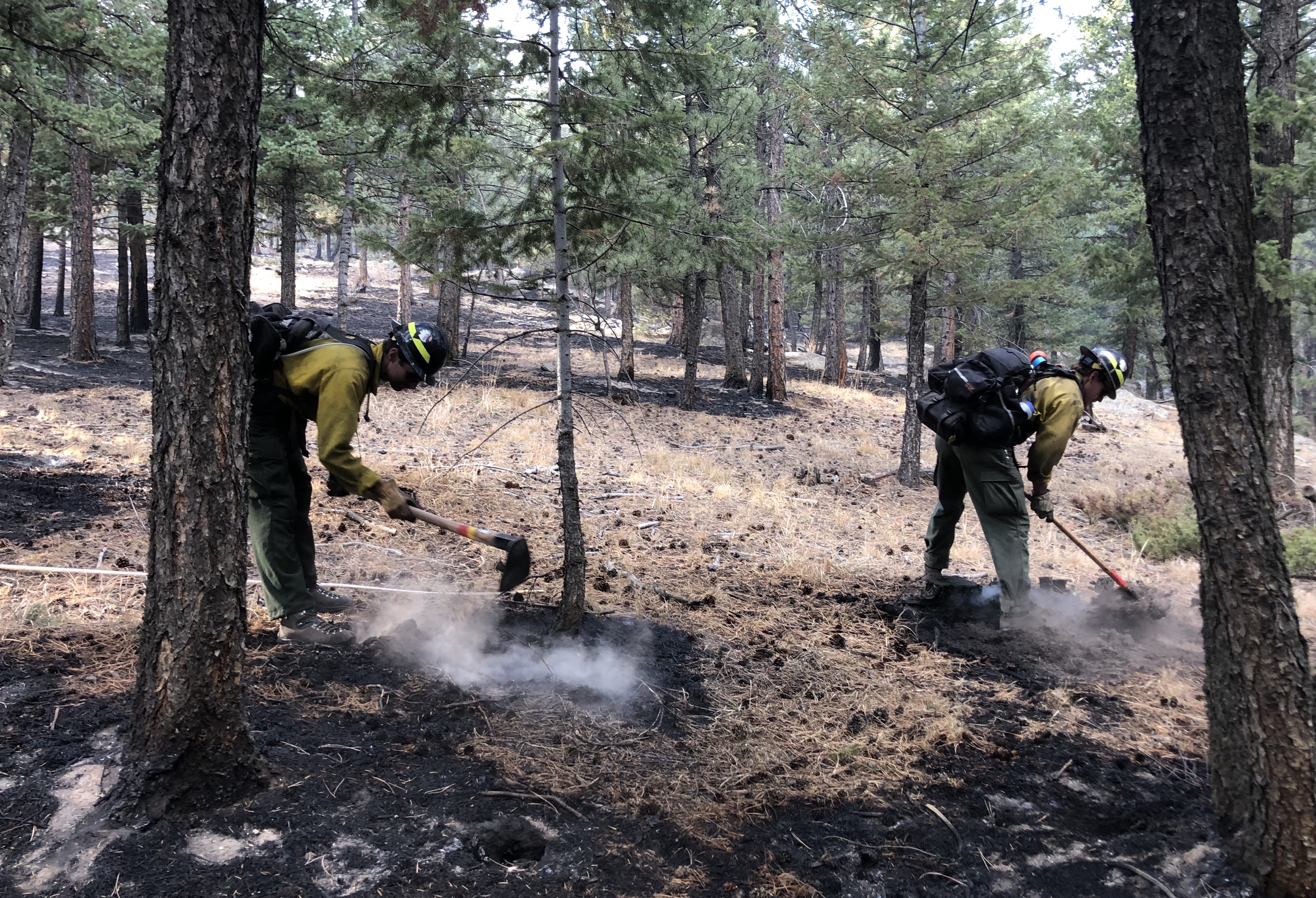
What is Containment?
We've been getting some questions about containment. Containment on a wildfire means that a fuel break has been completed around the fire’s perimeter and fire managers are confident that the fire will not spread past the line. The fuel break, or line, may include natural barriers or a manually or mechanically constructed line around the fire.
When building fireline, firefighters remove all vegetation down to “mineral soil,” meaning that there is no vegetation above or below the surface. Plant and grass roots can carry fire underground. Generally, a fireline is 10 to 12 feet wide, but it depends on fuel type. The guideline for the width of a fire line is 1.5 times the height of the burning fuels.
When determining where to place potential firelines, fire managers often use manmade or natural barriers, such as roads or rock outcroppings or bodies of water. On the CalWood and Lefthand Canyon Fires, firefighters have constructed hand lines and heavy equipment like bulldozers have been used to remove vegetation and improve roadbeds so that they could become stronger containment lines.
From the edge of the line, firefighters will “cold trail” on the interior of the line, which is checking to see whether there’s any heat that could compromise the line. When cold trailing, firefighters will remove their gloves and check areas with their bare hands to see if they feel heat. Cold trailing is an important part of mopping up a fire.
On the CalWood and Lefthand Canyon fires, firefighters are checking from one to two “chains” toward the interior, depending on fuel type. A chain is a method of measurement in wildland firefighting and one chain is 66 feet.
The black line you see on a fire map designates the containment line. On the CalWood Fire today, containment is 76%. The Lefthand Canyon Fire has been 100% contained since Thursday.
25 octubre Actualizacion de los Incendios Calwood y Lefthand Canyon Fire
Related Incident:
Publication Type: News
Situación Actual: El incendio CalWood ha llegado a 76% de contención este sábado. El comportamiento del fuego fue mínimo ayer, aunque estaba una advertencia de Bandera Roja en efecto. Se observo humo en los dos incendios, pero los dos incendios se mantuvieron dentro las líneas de contención. Se emitió una advertencia de tormenta invernal sobre el área del incendio hasta el lunes a las 6 de la mañana.
Una tormenta invernal se ha movido al área del incendio, trayendo un potencial de nieve considerable y temperaturas bajas peligrosas. Esta mañana, el liderazgo del equipo Rocky Mountain Team Black estará monitoreando las condiciones del incendio y la accesibilidad cerca de los incendios CalWood y Lefthand Canyon, La nieve, las temperaturas frías y el viento están creando condiciones peligrosas en las carreteras y dificultad en accesibilidad en muchas áreas. Los bomberos continuaran a reforzar y establecer líneas de fuego cuando ya no sea peligroso para ellos.
Cuando las condiciones de las carreteras mejoren y la nieve empiece a derretirse, la limpieza y las reparaciones empezaran en las líneas de contención. Cuando nos referimos a “limpieza” lo que estamos haciendo es extinguir áreas calientes para asegurar que el fuego no tenga la habilidad de continuar su movimiento fuera del área de contención establecida. La limpieza incluye separar escombros, asegurar que brasas estén completamente extinguidas, o mover árboles o vegetación quemada para que no ruede costa abajo y prenda otras áreas que no se han quemado. “Reparar” significa remover el equipo y maquinaria de la línea de fuego y cualquier señal de las acciones de supresión tomadas del paisaje.
Esta será la última actualización del incendio Lefthand Canyon al menos que mas actividad ocurra. El incendio Lefthand Canyon fue contenido el 23 de octubre y permanece 460 acres de tamaño.
Clima y Condiciones de Combustibles: Una advertencia de tormenta invernal esta en efecto en el área de los dos incendios desde las 6 a.m. el domingo hasta el lunes a las 6 a.m. Con la nieve, la tormenta traerá temperaturas frías al área del incendio, con temperaturas de 8 a 15 grados hoy. Es posible que se acumule de 3 a 7 pulgadas de nieve en baja altitud y de 9 a 12 pulgadas en altitudes mas altas. Dado a la nieve no se espera que el fuego sea activo hoy. Las posibilidades de nieve disminuirán para el lunes.
October 25 CalWood and Lefthand Canyon Fire Update
Related Incident:
Publication Type: News
CalWood and Lefthand Canyon Fire Update
Sunday, October 25, 2020, 9:00 a.m.
Rocky Mountain Incident Management Team Black
Troy Hagan, Incident Commander
Containment increases on CalWood Fire Ahead of Winter Storm Warning
Current Situation: The CalWood Fire reached 76% containment on Saturday. Fire behavior on both fires was minimal yesterday despite a Red Flag Warning being in effect. Smoke was observed from the fires, yet both fires remained inside established containment lines. A winter storm warning has been issued through 6 a.m. Monday morning for the fire area.
A winter storm has moved into the area, bringing the potential for significant snowfall and dangerously low temperatures. This morning, leadership from the Rocky Mountain Team Black will be monitoring fire conditions and accessibility near the CalWood and Lefthand Canyon fires. Snow, cold temperatures, and wind are creating unsafe wind chills, road conditions, and difficult access in many areas. When safe to do so, firefighters will continue reinforcement of established firelines.
As the road conditions improve and snow starts to melt, mop up and repair operations will begin along containment lines. “Mop up” is a term used to describe extinguishing residual fire to ensure the fire does not have the ability to continue to spread outside of an established containment line. Mop up includes actions like breaking apart smoldering debris, ensuring embers are completely extinguished, or moving burned debris so it cannot roll downhill and ignite previously unburned fuels. “Repair” means removing equipment from the fireline and signs of suppression actions from the landscape.
This will be the last update on the Lefthand Canyon Fire unless significant activity occurs. The Lefthand Canyon Fire was contained on October 23 and remains 460 acres.
Weather & Fuel Conditions: A winter storm warning is in effect for the area over both fires from 6 a.m. Sunday morning until 6 a.m. Monday morning. In addition to snow, the storm will bring cold temperatures to the fire area, with high temperatures ranging from 8-15 degrees today. New snow accumulation of 3 to 7 inches is possible at lower elevations and 9 to 12 inches is possible in upper elevations. Due to the snow fall, fire is not expected to be active today. Chances of more snow will diminish by Monday.
Closures and Evacuations: Boulder County lifted the road closure for Highway 7 in South St. Vrain Canyon this morning. For more information on road closures and evacuations in Boulder County, please visit the Boulder County Office of Emergency Management website at https://boulderoem.com or visit https://arcg.is/0Lq5fD.
The U.S. Forest Service has a temporary closure in place for all activities on Arapaho and Roosevelt National Forests lands in Grand, Clear Creek, Jefferson, Gilpin, Boulder, and Larimer counties; for more information on these emergency closures, please visit https://go.usa.gov/x7CZJ. Multiple Boulder County Parks and Open Space properties are closed to public use; for more information on these closures, please visit https://boco.org/BCPOSfireclosures.
Air Quality: The Lyons, Longmont and areas near Boulder may experience moderate levels of smoke on Sunday. Please visit the CDPHE Air Quality page or find more localized information at https://airnow.gov. A smoke forecast is available for the central Front Range; please visit https://wildlandfiresmoke.net/outlooks/CentralColoradoFrontRange for more information.
Emergency Alerts: Boulder County has an emergency notification system that allows residents of the county and all cities within to be notified of emergency situations. Notifications can be received in a variety of ways, including cell and land line phones, by text and/or by email. To sign up for alerts, please visit www.Boco911Alert.com.
Temporary Flight Restrictions: Temporary Flight Restrictions are in place over the Calwood and Lefthand Canyon fires. Wildfires are a No Drone Zone. If you fly, we can’t. Whenever a drone is spotted near the fires, all aircraft will be grounded until the drone is confirmed as clear of the area. For more information, visit http://knowbeforeyoufly.org.
CalWood Fire Statistics:
Size: 10,095 acres
Containment: 76%
Total Personnel: 376
Location: 3 miles N of Jamestown, CO
Reported: October 17
Cause: Under Investigation
Lefthand Canyon Fire Statistics:
Size: 460 acres
Containment: 100%
Total Personnel: 24
Location: 1 mile E of Ward, CO
Reported: October 18
Cause: Under Investigation
For More Information:
Fire Information Office: (720) 310-5598
Interactive Story Map: https://arcg.is/1ybX0u
CalWood InciWeb: https://inciweb.nwcg.gov/incident/7245/
Lefthand Canyon Inciweb:https://inciweb.nwcg.gov/incident/7247/
Facebook: @CalWoodAndLefthandCynFires
24 de octubre Actualizacin de los Incendios Calwood y Lefthand Canyon
Related Incident:
Publication Type: News
Actualización de los Incendios Calwood y Lefthand Canyon
Sábado, 24 de octubre, 2020, 9:00 a.m.
Equipo de Gerencia de Incidentes Rocky Mountain Team Black
Troy Hagan, Comandante de Incidente
El Incendio CalWood Aumenta en Contención tras la Advertencia de Bandera Roja
Situación Actual: La contención del incendio CalWood aumento este viernes dado a que la mayoría del área del incendio tuvo poca actividad durante el día. Se observo algo de calor y humo alrededor de los dos incendios, pero todas las líneas de contención se mantuvieron fuertes. Las tripulaciones pudieron aumentar la contención y continuaron a enforzar las líneas corta fuego en el borde al sur del incendio
Hoy, una advertencia de Bandera Roja sigue en pie dado a los efectos de fuerte vientos esta tarde y durante el domingo en la mañana a medida que se mueve un frente frio al área. Se espera que los bomberos tomen ventaja de las condiciones al frente del viento de esta tarde para continuar con el éxito de ayer. La prioridad es enfocarse en aumentar la contención mejorando y sofocando las líneas corta fuego en la mayoría del borde del incendio. A medida que el incendio se mueve hacia la autopista 7, los bomberos están patrullando y mejorando las líneas a lo largo de la porción del fugo que ya está contenido. Equipos están buscando oportunidades para construir líneas corta fuego para prevenir que se esparza el incendio hacia el cañón St. Vrain.
El incendio Lefthand Canyon alcanzo 100% de contención el jueves. Equipos siguen sofocando y patrullando las líneas de contención. Los bomberos están asignados a patrullar y hacer mejoramientos donde es necesario.
Clima y Condiciones de Combustibles: Una advertencia de Bandera Roja sigue en efecto en las dos áreas del incendio desde el sábado en la medianoche hasta el domingo a las 3 a.m. a causa de fuerte viento que viene desde el oeste empezando esta tarde. Se espera que la humedad se mantendrá más arriba de 25% durante el día. El viento y las condiciones más secas en los dos incendios pueden aumentar las condiciones de combustión la tarde del sábado. Es posible que los dos incendios se activen dado al viento y ráfagas de hasta 45 millas por hora en las montañas y 35 millas por hora en los valles, y hasta 60 millas por hora en los cañones.
Clausuras y Evacuaciones: La oficina del Sherif del condado de Boulder hizo modificaciones en algunas ordines de evacuación y advertencias de evacuación el viernes. Para más información sobre evacuaciones para los dos incendios, por favor visite https://arcg.is/0Lq5fD o https://boulderoem.com.
El servicio forestal de los Estados Unidos puso una clausura temporal sobre los bosques nacionales Arapaho y Roosevelt en los condados de Grand, Clear Creek, Jefferson, Gilpin, Boulder y Larimer; para más información sobre estas clausuras de emergencia, por favor visite https://go.usa.gov/x7CZJ. Parques y Espacios Abiertos del Condado de Boulder cerro muchas propiedades al uso público el miércoles; para más información sobre estas clausuras, por favor visite https://boco.org/BCPOSfireclosures.
Calidad del Aire: A causa del incendio East Troublesome y otros incendios muchas áreas pueden experimentar niveles de humo desde moderado hasta Peligroso para Grupos Sensibles (USG en inglés) incluyendo altitudes altas de los condados de Larimar y Boulder. Los drenajes entre Allenspark, Boulder y Longmont pueden experimentar un nivel de humo moderado el viernes y el sábado en la mañana. Por favor visite la página de calidad de aire CDPHE o encuentre información más localizada en https://airnow.gov. Un pronóstico de humo está disponible para el rango frontal; por favor visite https://wildlandfiresmoke.net/outlooks/CentralColoradoFrontRange para más información.
Alertas de Emergencia: El condado de Boulder tiene un sistema de notificación que deja saber a los residentes del condado acerca de situaciones de emergencia. Se pueden recibir notificaciones de varias formas, incluyendo celular o línea fija de teléfono, por texto y/o correo electrónico. Regístrese para recibir estas alertas visitando la página www.Boco911Alert.com.
Restricciones de Vuelo Temporales: Restricciones de vuelo temporales están en pie sobre los incendios Calwood y Lefthand Canyon. Los incendios forestales son una zona prohibida para los drones. Si usted vuela, nosotros no podemos hacerlo. Siempre que se detecte un avión no tripulado cerca de los incendios, todos los aviones estarán en tierra hasta que se confirme que el avión no tripulado esté fuera del área. Para más información por favor visite http://knowbeforeyoufly.org.
Estadísticas del Incendio CalWood:
Tamaño: 10,095 acres
Contención: 66%
Personal Total: 495
Ubicación: 3 millas N de Jamestown, CO
Reportado: 17 de octubre
Causa: Bajo investigación
Estadísticas del Incendio Lefthand Canyon:
Tamaño: 460 acres
Contención: 100%
Personal Total: 50
Ubicación: 1 milla E de Ward, CO
Reportado: 18 de octubre
Causa: Bajo investigación
Para más Información:
Oficina de Información del Incendio: (720)-310-5598
Centro de Llamadas del Condado de Boulder: (303) 413-7730
Mapa historial Interactivo: https://arcg.is/1ybX0u
CalWood InciWeb: https://inciweb.nwcg.gov/incident/7245/
Lefthand Canyon Inciweb:https://inciweb.nwcg.gov/incident/7247/
Facebook: @CalWoodAndLefthandCynFires