
Prescribed Fire Projects November 1920 2020
Related Incident:
Publication Type: Announcement
Several prescribed fire pile burn projects are happening November 19-20, 2020, including:
Trinity and Divide piles located east of Trinity Lake along the Trinity Divide, 23 acres total.
Black Fox and Elk Piles located northeast of McCloud, 582 acres total.
Hirz Piles located near Girard Ridge southeast of Dunsmuir, 130 acres total.
Closures Change within the ET Burn Area as Aerial Mulching wrap up
Related Incident:
Publication Type: News
GRANBY, Colo., – East Troublesome Fire recovery efforts have made great strides since the start of Colorado’s second largest fires last year. Recovery work has ranged from trail clearing to road and bridge repair, to habitat and burn severity mapping, to hill stabilization through aerial mulching, and more. Aerial mulching and some additional road and bridge repairs have been completed, resulting in updated closures for the East Troublesome burn area.
Within the East Troublesome closure, the Forest Service will be reopening roads in the Supply Creek area, including the Supply Creek Trailhead and the North Supply Trailhead which were previously closed for aerial mulching operations. Additionally, Buffalo Creek road will be opening as a result of extensive bridge and road repair. An updated map is available on the Forest Service website.
Restoration work has been a large focus for the Arapaho and Roosevelt National Forests this year in response to post fire recovery needs and changing conditions in the burn areas. The most recent closure changes focus on reopening lands that were temporarily closed due to restoration work and marks another step in the recovery process. As we move into the fall and winter months, closures are still in place for public safety and to enable the forest to regenerate naturally. The Arapaho National Forest continues to work with partners to identify recovery needs, protection of resources, planning and implementation of work.
As burn area closures continue to change, and we approach the first deer and elk rifle seasons, please be aware of safety hazards you may encounter that may not be visible as snow starts to fall. When hiking within the burn area you could encounter falling or downed trees, flood risks, stump holes, and rock fall danger, to name a few, even in locations that have been opened. Remember your safety is your responsibility. Visitors are also reminded many areas impacted by the fires remain closed, partially closed or will be closing for the winter season. To help people plan their visit, we recommend everyone check the Know Before You Go page for helpful tips and closure information.
One year later Partners reflect on East Troublesome Fire recovery
Related Incident:
Publication Type: News
GRANBY, Colo. (Oct 14, 2021) – One year ago today, firefighters responded to a smoke report in the East Troublesome area of the Arapaho National Forest north of Hot Sulphur Springs. Fighting the fire in extraordinarily difficult terrain amidst shifting winds and historically dry and warm conditions with limited resources created enormous challenges, and the fire grew rapidly, repeatedly crossing containment lines as it grew east toward Colo. Highway 125.
One week later, exhibiting behavior unlike anything scientists and fire managers had ever seen, the fire crossed Colo. 125 and made a 20-mile run across northern Grand County, burning 589 homes and structures and taking two lives before jumping the Continental Divide in Rocky Mountain National Park and heading toward the Town of Estes Park.
A winter storm Oct. 25 brought very cold temperatures and snow, resulting in a dramatic drop in fire behavior with smoldering and reduced fire spread on both sides of the Continental Divide. The fire was declared contained on Nov. 30, 2020. At 193,892 acres, East Troublesome is the state’s second largest fire in history. The cause of the fire is still under investigation.
As Sheriff Brett Schroetlin reflected on the firestorm and resulting devastation from the East Troublesome Fire, he shared, “I am humbled by the strength of the people that make up the Grand County community and their resilience to persevere through the last twelve months of their very personal recovery.”
In the 12 months since these devastating events, recovery teams, land managers and water providers have turned their attention to post wildfire emergency response and recovery efforts. A collaborative stakeholder group continues to meet monthly to discuss priorities, challenges, and successes; and to protect their critical source water infrastructure. This collaborative recovery group includes Grand County, Northern Water, the USDA Forest Service, Rocky Mountain National Park, USDA Natural Resources Conservation Service, U.S. Geological Survey, Colorado Office of Emergency Management, and Bureau of Reclamation among others.
Aerial mulching, water monitoring, utility infrastructure protections, and stabilizing and reopening trails and roads has been a critical part of the work.
“In the weeks and months following the East Troublesome Fire, Northern Water recognized the significant impacts the fire would have on the Upper Colorado River watershed, which is the source of water for more than 1 million residents in Northeastern Colorado,” said Esther Vincent, Director of Environmental Services for Northern Water. “That’s why we partnered with Grand County to be the local sponsors for the Emergency Watershed Protection Program, administered by the Natural Resources Conservation Service.”
Using funds through the federal EWP Program, matched with money from the Colorado Water Conservation Board, Northern Water and Grand County have worked with private landowners and other public agencies to develop projects that would protect human life and property in the burn area. To date, this effort has focused on more than 5,000 acres of aerial seeding and mulching and installing debris booms to protect key water infrastructure during summer monsoon events. More work is planned in 2022, and the effects of the fire on the watershed will be felt for years to come.
“A vast portion of the burned area was Arapaho National Forest lands that are a critical part of the Grand County tourism and recreation economy,” said acting Sulphur District Ranger Kevin McLaughlin. “Our focus has been on reopening as much of our road and trail system as we safely can.”
Forest Service and Rock Mountain Youth Corps crews spent the summer working with partners, collaborators, and hundreds of volunteers coordinated through Grand Lake Trailgrooming Inc. and Headwaters Trails Alliance to cut more than 10,000 burnt, broken and fallen trees from 120 miles of trails. Crews also dug hundreds of drainage bars to prevent trail washouts and hundreds of miles of roads were reopened after road crews worked to stabilize them.
“This has been a truly massive undertaking to this point and there is an incredible amount of work yet to be done,” McLaughlin said, noting that an estimated 50 to 70 bridges, boardwalks and turnpikes burned in the fire and all need to be replaced next year in addition to various campground infrastructure that burned and roads that were impacted by the monsoons this summer. “We wouldn’t have been able to make the progress we have without our partners, and we look forward to continued collaboration on fire recovery in the years to come.”
The Grand County Board of Commissioners released this statement: “On the anniversary the worst disaster in recent Grand County history, the Commissioners would like to extend our deepest appreciation to the emergency agencies, volunteers, organizations, and companies that helped our community survive, recover and rebuild. While there is still recovery work to be done, we have no doubt the strength and resilience of our Grand community will see us through.”
To commemorate the anniversary of the East Troublesome Fire, the Grand Lake Chamber has planned two events at Grand Lake Town Park: “We gather to Acknowledge” at 7 p.m. Oct. 21 with a moment of silence followed by the ringing of a bell to acknowledge the night we left our homes; and “We gather to remember” at 11 a.m. Oct. 23, which includes a free Community lunch, local music, a community art piece, and an opportunity to thank first responders over a shared meal.
East Troublesome Fire Burned Area Emergency Response BAER Update
Related Incident:
Publication Type: News
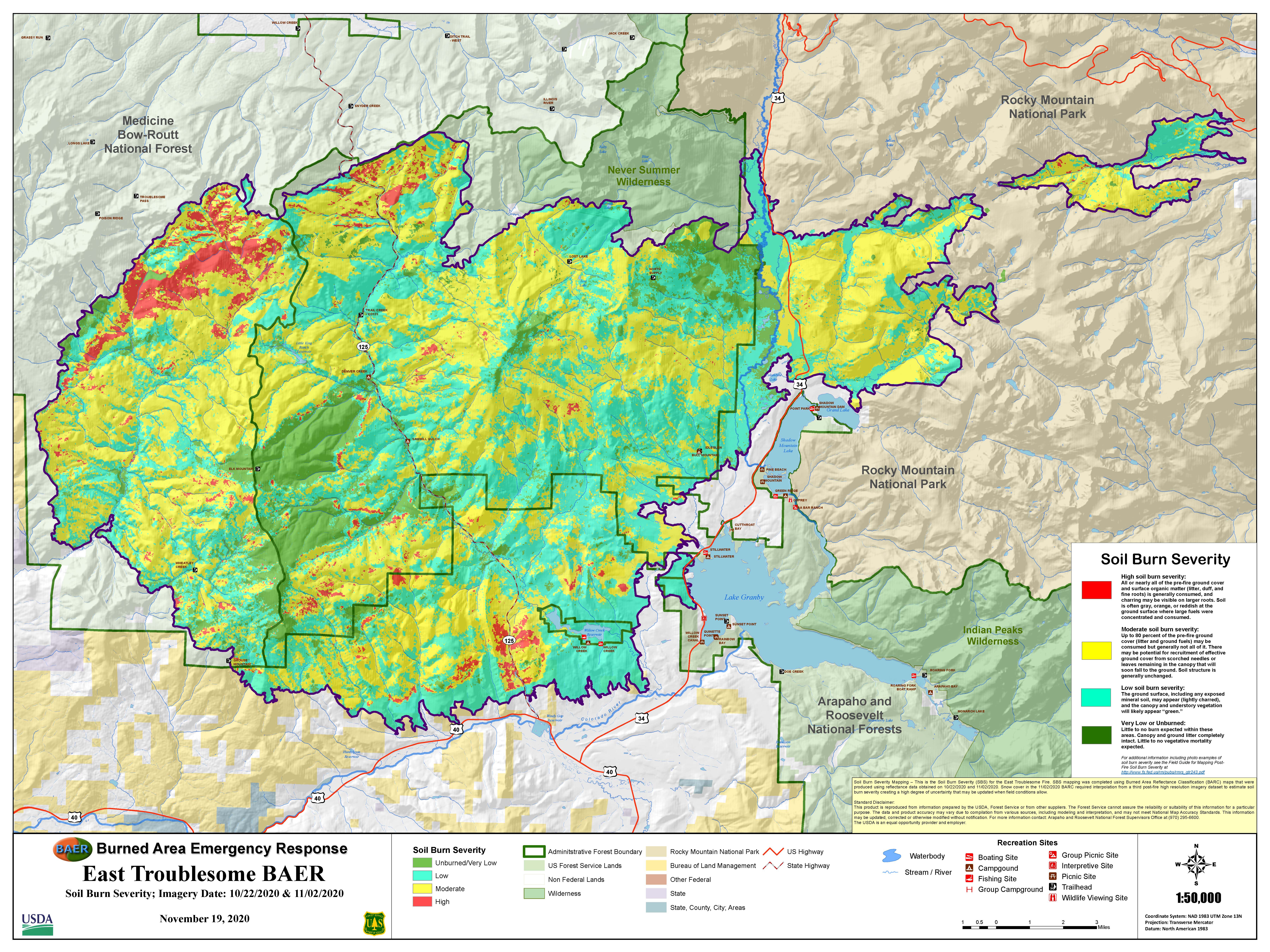
The second round of BAER analysis is complete.
Conclusion excerpt from document:
The BAER team identified threats to BAER critical values based on two field assessments. The assessments were conducted using the best available methods to analyze the potential for erosion, flooding, debris flows, and hazard trees in a rapid manner. Treatment recommendations focus on mitigation measures to minimize life/safety threats, and damage to property. These mitigations include road and trail closures, trail stabilization, campground treatments, and warning signs.
The soil erosion, hydrology, and debris flow modelling results indicate that post-fire there will be an increase in watershed response. This means:
• Increased erosion and sedimentation
• Areas that flood or have debris flows pre-fire will have larger magnitude events
• Areas that occasionally flood or have debris flows will see more frequent events
• Areas that previously did not have streamflow or debris flows may now flood or have debris flows
The findings provide information that can assist other agencies and landowners in preparing for post-fire threats. The US Forest Service will continue to participate in interagency efforts to address threats resulting from the East Troublesome Fire.
Road closures change near East Troublesome Fire area
Related Incident:
Publication Type: Announcement
Road closures change near East Troublesome Fire area
Closures Adjusted on Routt and Arapaho National Forests
Related Incident:
Publication Type: Closures
In early July, closures were adjusted on the Routt and Arapaho National Forests. These closures permit day use but prohibit overnight occupancy. Some roads and trails remain closed.
Arapaho National Forest Closure and Map
- Restricted Areas
- The NFS lands 300 feet from the centerline of NFS Roads 835.2A and 835.2B (the “Bull Mountain Camping Area”).
- The NFS lands within 1/4 mile on either side of NFS Roads 119.1, 120, and 120.4 (the “Supply Creek Area”).
- Restricted Roads
- 112, 112.1A (from Forest Road No. 112 to the southernmost end of the existing road), 112.1E, 112.3N, 116, 116.2, 116.2M, 120.Y, 120.5, 121.1, 123.2A, 123.2B, 123.2G, 190.A, 190.1 (West side accessed by Forest Road No. 121.1), 258.1, 258.1D, 258.2, 265.1, 266.1, 267, 267.1D, 750 (From the boundary of the Parks Ranger District to the intersection of Forest Road No. 266.1), 814.1, 816.2. 818.1, 820.2, 827.1, 831.1A, 835.2B, 835.2C, and 835.3
- Restricted Trails
- N27 Elk Mountain, N37 Drowsy Water, N38 McQueary Ridge, N51 Buffalo Creek, N53 Bill Miller, N54 Paradise Creek, N199 Trail Creek, N199.1 South Trail Creek, M50 Sherman Creek, M113 Camway, M114 (from the intersection of FSR 116.1 to the southernmost portion of Forest Road No. 116), M115 Lower Gilsonite (Between Forest Road Nos. 123 and 123.2B), M116 Beaver Line, M118.2 Gilsonite II, M120 Soda Pass, M121 Blizzard Pass, M122 Burn, M123 Middle Supply, M124 North Supply Loop, M125 Spruce Em Up Jack, and M136 Eagle Perch Overlook
- Prohibited Activities
- Being on National Forest System roads 12 and 112 and all associated spur roads
- Camping on National Forest System lands within the burn area
- Restricted Roads
- 12 (from Forest Boundary to intersection with FS 112), 111, 112 (from Southern Forest Boundary to northernmost end of the existing road), 112.6B, 112.6D, 112.6E, 121, 121.1B, and 125
East Troublesome Fire area remains closed as fire recovery efforts continue
Related Incident:
Publication Type: News
Fire danger west of divide climbs to VERY HIGH; Check for fire bans!
GRANBY, Colo (June 14, 2021) – A second round of post-fire emergency assessments are underway in the East Troublesome Fire burn area on the Arapaho National Forest in Grand County, Colo. Forest Service specialists are in the area this week assessing burn severity, emergency stabilization needs and other requirements to protect life and safety within the burn area.
The East Troublesome burn area and all access points remain CLOSED to the public until these stabilization and mitigation efforts can be implemented. Currently, post-fire restoration efforts and fireline rehabilitation work is active in multiple locations across the burn area.
The East Troublesome Fire burned so late in the fall season last year that snow fell on the fire before Forest managers could get a clear picture of the fire impacts and implement stabilization and life safety mitigations. The Forest Service has had to wait until the snow melted this spring to start this work. Much of the fire area is expected to remain closed until critical actions can be taken to prevent further emergencies from occurring.
The types of actions that could be taken include: pulling culverts to prevent debris buildup and road washouts; building water bars on trails to prevent runoff and sedimentation into streams; installing hazard signage; removing and possibly replacing destroyed infrastructure such as bridges; cutting down hazardous burned trees along roads and trails to pose an immediate life-safety threat; rehabilitating fireline that helped slow the fire spread; and stabilizing slopes that pose a risk to visitors and streams.
In addition, a collaborative fire recovery team is working to prevent post-fire impacts to rivers and reservoirs. Stream gauges are being installed in the area to provide an early alert system to the public when flooding occurs while debris booms are being installed to prevent the movement of fire debris into reservoirs.
The public living and recreating near any fire area should be aware that post-fire flooding is a real danger following a hard rain. Be sure to check the weather forecast and sign up for alerts through the National Weather Service and Code Red in Grand County. Avoid camping in low lying areas near or downstream of a burned area.
Finally, much of western Colorado and Wyoming remain in extreme drought conditions. The risk of starting another wildfire is VERY HIGH. Be sure to check for fire restrictions for the area. If fires are allowed, be sure to drown and stir them completely until the coals are cold enough to hold. If stage one fire restrictions are in place, campfires will not be allowed outside of developed campgrounds with fees and hosts.
Help us prevent more wildfires and become a steward of these places we all must care for by checking the official local source for the Arapaho and Roosevelt National Forests at www.fs.usda.gov/goto/arp/knowbefore or the Medicine Bow and Routt National Forests at https://www.fs.usda.gov/detail/mbr/fire/?cid=FSEPRD889210.
Learn more about East Troublesome Fire post-fire recovery efforts on Inciweb, Grand County Watershed Recovery and Grand County’s Office of Emergency Management.
EMERGENCY AREA CLOSURE ORDER East Troublesome Fire Area
Related Incident:
Publication Type: Closures
An area closure is in place for the East Troublesome Burn Area on the Arapaho, Roosevelt, and Routt National Forests.
View Forest Order PDF.
View Exhibit A, Closure Area Map.
USDA FOREST SERVICE ARAPAHO AND ROUTT NATIONAL FORESTS PARKS AND SULPHUR RANGER DISTRICTS
EMERGENCY AREA CLOSURE ORDER
East Troublesome Fire Area
Pursuant to Title 16 U.S.C. § 551, and Title 36, Code of Federal Regulations (CFR), § 261.50 (a) and (b), the following acts are prohibited on National Forest System lands within the Arapaho and Routt National Forests in Grand County within the Parks and Sulphur Ranger Districts in the State of Colorado (“Restricted Areas”) and on all roads and trails located xstricted Area (the “Restricted Roads and Trails”). Privately-owned lands within the Restricted Areas are excluded.
The Restricted Area is depicted on the attached maps, hereby incorporated into this Order as Exhibits A and B maps and as follows: from the southwest corner of the Routt National Forest Boundary, continue north to Forest Service Road 104.1, follow Forest Service Road 104.1 along the Forest Boundary to the point that the road turns northwest and leaves the Forest Boundary, continue east along the Forest Boundary to the intersection of the Never Summer Wilderness boundary, continue south along the west boundary of the Never Summer Wilderness to a point at the southwest corner of the Never Summer Wilderness boundary, continue east on the southern boundary of the Never Summer Wilderness to the intersection of the Forest Boundary with the Rocky Mountain National Park Boundary, continue south along the Forest boundary to Hwy. 34, continue south along the west side of Hwy. 34 to the Forest Boundary, continue west along the south end of the Forest Boundary to the beginning of the description.
Within this Restricted Area described above, the following roads, trails and areas are open for use depicted on the attached Exhibits A and B and as follows: Hwy. 125, National Forest System Road (NFSR) 123 from the Forest Boundary at the intersection of County Road 4 north to and including the Idleglen Trailhead and Parking Area, Lower Soda Pass Trail, Kawuneeche Trail, South Supply Trail, North Supply Trail, Pony Park Trail, Stillwater Pass Trail, Whiskey Park, Hatchet Park, Hot Dog Park, Willow Park, Chicken Hill, Pony Park, and Rob Roy Park.
The Restricted Area also includes an area around County Road 40 and Hwy. 34 depicted on the attached Exhibit A map and as follows: from the intersection of the west side of Hwy. 34 and County Road 40 (remains open) continue south along the west side of Hwy. 34 to the south end of the Forest Boundary, continue west to the west side of the Forest Boundary, continue north to the northwest corner of the Forest Boundary, continue east to the west side of Hwy. 34, continue south along the west side of Hwy. 34 to the beginning the description.
The Restricted Area also includes an area around the Willow Creek Reservoir depicted on the attached Exhibit A map and as follows: from the intersection of County Road 40 (remains open) and the west side of NFSR 600.1A (remains open) continue west along south side of County Road 40 (remains open) to the west side of NFSR 600, continue north along the west side NFSR 600 to the Willow Creek Reservoir water line, continue east along the water line to the west side of the boat ramp (remains open) and NFSR 600.1A (NFSR 600.1A, the boat ramp and restroom facility on the west side of NFSR 600.1A remain open), continue south to the beginning of the description.
PROHIBITIONS: This Order prohibits the following acts in the Restricted Area:
- Being in the Areas depicted in Exhibit A. 36 CFR 261.52(e).
- Being on the Roads depicted in Exhibit A. 36 CFR 261.54(e).
- Being on the Trails depicted in Exhibit A. 36 CFR 61.55(a).
EXEMPTIONS: Pursuant to 36 CFR § 261.50(e), the following persons are exempt from this Order:
- Any Federal, State or local officer, or member of an organized rescue or firefighting force in the performance of an official duty;
- Persons with a Forest Service permit specifically exempting them from the effect of this Order.
The purpose of this Order is for public health and safety within the East Troublesome Fire perimeter. This Order goes into effect when signed and shall remain in effect until November 30, 2021 or until rescinded, whichever occurs first.
Forest Service completes BAER assessments Recovery efforts underway
Related Incident:
Publication Type: News
FORT COLLINS, Colo. (Dec. 17, 2020) – In the aftermath of five wildfires, multiple teams of natural resource specialists have completed their initial assessments of burned areas on the Arapaho and Roosevelt National Forests. Cameron Peak, Williams Fork, East Troublesome, Cal-Wood and Lefthand fires collectively burned more than 323,000 acres of National Forest lands in 2020.
These rapid assessments, part of the “Burned Area Emergency Response” or BAER program, represent a small part of the greater, collaborative, post-wildfire recovery efforts currently underway with a coalition of local, state and federal agencies, scientists and natural resource managers. BAER is an initial step that focuses solely on National Forest lands and values at risk in the immediate aftermath.
“There’s a great deal of interest in the BAER effort initially because it’s our first real look at what took place out there during the fire,” said Forest Supervisor Monte Williams. “But, BAER is only one piece of the puzzle. Now that we have that piece in place, we’re focused on working closely with our partners to support the priorities we collectively identify, from protecting water resources and securing infrastructure to rehabilitating and rebuilding our recreation areas.”
BAER funding is limited in its scope. For instance, it doesn’t pay to rebuild burned outhouses in campgrounds; but it does provide funding to temporarily cap burned pit toilets for public safety reasons.
Extensive research since the Hayman and High Park fires has provided land managers with a deeper understanding of what immediate post-fire treatments are most effective at reducing post-wildfire impacts to watersheds. For example, pulling undersized culverts and digging water bars on trails has been found to be more effective at reducing sedimentation, runoff and flooding than scattering mulch, seed and haybales across the landscape. While these have been popular post-fire treatments in the past, they have been found to have limited benefit. These treatments risk introducing noxious weeds to the environment and add to the debris washing into streams.
“We have to consider where we get the most bang for the buck,” Williams said. “In the longer term, my hope is that these collaborative groups will work together beyond post-fire recovery to help prepare our landscapes to be more resilient to future wildfires.”
Given these fires’ extended duration into the late season, team’s assessment efforts were hampered by snow and hazardous conditions. As a result, teams will need to return to certain areas in the spring for further assessment. In addition, hundreds of miles of roads and trails across both the Cameron Peak and East Troublesome fires remain to be surveyed and stabilized.
BEAR Team East Troublesome Fire At Rocky Mountain National Park
Related Incident:
Publication Type: News
Rocky Mountain National Park News Release
December 11, 2020
For Immediate Release
Kyle Patterson 970-586-1363
Burned Area Emergency Response Team - East Troublesome Fire At Rocky Mountain National Park
A National Park Service Burned Area Emergency Response (BAER) Team was deployed in November to assess post fire impacts associated with the East Troublesome Fire within Rocky Mountain National Park. The team evaluated threats from flooding and debris flows as well as impacts to vegetation and wildlife, historic properties and recreation infrastructure.
The East Troublesome Fire was 100% contained at the end of November and burned 193,812 acres on US Forest Service, Bureau of Land Management, National Park Service and private land. 22,668 acres burned within Rocky Mountain National Park on both sides of the Continental Divide with the East Troublesome Fire.
The BAER team focused on the potential for dangerous flood events, debris flows resulting from vegetation loss and fire altered soils.
The BAER team is made up of specialists in hydrology, soil science, archeology, wildlife biology, botany, roads and trails and hydrologic modeling.
The team collected data during their burned area surveys and have presented their findings and recommended emergency stabilization treatments or actions in a BAER assessment report. When the BAER report is final, it will be shared with interagency cooperators who work to identify and prepare for potential post-fire flooding and debris flow impacts. This is one step toward recovery.
For more information about Rocky Mountain National Park, please visit www.nps.gov/romo or call the park’s Information Office at (970) 586-1206.