
Smoke Outlook for 617 618 NE Utah Bear and Bennion Creek Fires
Related Incident:
Publication Type: News
Special Statement
Red Flag Warning in effect today until 10PM Thursday due to gusty winds and low humidity.Fire
The Bear fire had a growth of 955 acres and is now at 12170 acres with 30% containment and the Bennion Creek fire grew only 13 acres and is 8329 and is 17% contained. Most of the growth from the Bear fire is due to increased boundary mapping. Persistent red flag conditions and instability over the fire area due to a system arriving late today will provide potential for rapid fire spread and fire growth.Smoke
Today there is a possibility of an increase in smoke due to a system arriving late today. The smoke is expected to drift North East of the fires today. The communities of Roosevelt, Vernal and Rangely will see smoke in the moderate ranges throughout the day. Helper and communities South of the fires will see similar conditions as yesterday. Depending on fire activity smoke impacts could increase due to erratic winds in the area. Moab will have moderate air quality today due to fire activity on the Pack Creek fire and smoke coming from fires in Arizona, New Mexico.Today's Message
The daily AQI forecast is based on the 24 hour average concentration. However if you smell smoke, you are breathing smoke. Stay indoors if you and avoid smoke if you are smoke sensitive or consider leaving the area until the smoke clears out of your area.Bennion Creek Fire Update June 17 2021
Related Incident:
Publication Type: News
Bennion Creek Fire: 8,329 acres, 34% containment. Began June 4, 2021.
Update: Containment on the Bennion Creek Fire has increased to 34%, and the fire remains at 8,329 total acres. The additional containment is along Starvation Road as well as the entire spot east of the road. Please note that today’s map does not reflect black containment around the entirety of this spot, but the mapping will be updated tomorrow. A printable version of today’s fire map may be found here: https://tinyurl.com/6ewxtm9n .
Additional engines and hand crews will be supporting today’s firefighting operations. Around the southeast corner of the fire, crews will continue plumbing work to provide water support on the fire’s edge. Two additional crews will establish containment lines, monitor and mop-up the western perimeter of the fire. Work along Starvation Road will continue to strengthen containment lines. Firefighters will continue to secure structures around Scofield Estates and Sugar House Camp. On the southeast flank of the fire, firefighters will continue their work to along the dozer line and grid for areas of heat.
Weather: A RED FLAG WARNING is in effect for the fire through tonight, bringing the potential for rapid fire spread. The fire area will experience temperatures near 88° at upper elevations today with winds along the ridgetops gusting 25-30 mph this afternoon. These conditions are expected to produce critical fire weather conditions this afternoon through this evening. Friday’s weather will bring the chance of dry thunderstorms with erratic, gusty winds.
Resources: A total of 283 firefighters are assigned to the fire. Resources include 10 hand crews, 5 helicopters, 14 Engines, and 2 dozers.
Closures: Bennion Ridge Road, Forest Road 0008 (Bear Ridge Road), Starvation Road, and Fish Creek Trail. These closures are for public and firefighter safety.
Evacuations: There are currently no mandatory evacuations for the fire.
Restrictions: There are fire restrictions in effect on state and Utah BLM lands. A Stage 1 Fire Restriction will go in to effect on the Manti-La Sal on June 18, 2021. Complete information on all of these restrictions may be found at https://inciweb.nwcg.gov/incident/announcements/7518/ .
Jurisdiction: The fire is in the jurisdiction of the Manti-La Sal National Forest, Bureau of Land Management, state and private lands. California Interagency Incident Management Team 10 is managing the fire.
Bennion Creek Fire Brief Evening post June 16 2021
Related Incident:
Publication Type: News
The Bennion Creek Fire remains 17% contained as of this afternoon with an expected increase of containment by tomorrow morning. With assistance from helicopter’s bucket drops they are able to move further into the interior to extinguish the hot-spots deep in the stands of aspens and conifers. High temperatures, gusty winds and steep terrain have made for challenging firefighting efforts. With the increase of containment and the decreased threats to structures, this afternoon the mandatory evacuations for the Aspen Cove area have been lifted. Road closures and trail closures are still in effect and we ask that the public refrain from traveling in and around the area for both their and firefighters safety. A Red Flag Warning remains in effect through tomorrow evening throughout the region with expected dry lightning and gusty winds.
Aspen Cove Evacuation Lifted
Related Incident:
Publication Type: Announcement
The mandatory evacuation for residents of Aspen Cove is lifted as of 6:00 p.m., June 16, 2021.
MantiLa Sal National Forest Enters Stage 1 Fire Restrictions on June 18
Related Incident:
Publication Type: Announcement
Please note - the complete order, news release and map may be found under Related Information below.
Manti-La Sal National Forest enters Stage 1 fire restrictions
PRICE, Utah, June 14, 2021 – Due to record dry conditions and continuing extreme fire danger, Manti-La Sal National Forest will implement Stage 1 fire restrictions for all National Forest System lands located within the Sanpete, Ferron/Price, Moab and Monticello Ranger Districts of the Manti-La Sal National Forest boundaries beginning 12:01 a.m. June 18, 2021.
“We find conditions out on the Forest are extremely dry and due to two consecutive winters of less than normal snowpack, fire restrictions are necessary to reduce the threat of wildfire and to keep everyone safe while recreating on our public lands,” said Darren Olsen, acting Manti-La Sal Forest Supervisor.
Manti-La Sal is currently experiencing two large wildfires burning within the forest boundaries, the Bennion Creek Fire in the northern portion of the forest and the Pack Creek fire burning in the La Sal mountain range area. Both fires have exhibited extreme fire behavior due to the drought-like conditions and high winds.
With a noticeable increase in public recreation on the Forest, the potential for human-caused fires also increases. Restrictions are placed to reduce the potential for human-caused fires. Remember to recreate responsibly during visits to the Manti-La Sal.
The following acts are prohibited until fire danger decreases and fire restrictions are rescinded:
· Igniting, building, maintaining, or using a fire, including charcoal and briquettes, outside a fire structure that is provided by the Forest Service within a designated area.
· No discharging of fireworks or other pyrotechnic devices outside of incorporated city limits. This applies year-round to national forest lands.
· No shooting of exploding targets or tracer ammunition. This applies year-round to national forest lands.
· No cutting, grinding, or welding of metal in areas of dry vegetation. This includes acetylene torches.
· No use of equipment without a working and properly maintained spark arrestor. This applies year-round to national forest lands.
· No smoking near vegetation or outside of a developed recreation site, personal vehicle, or building.
Designated areas on the Manti-La Sal are defined as all developed recreation sites (campgrounds and picnic areas) that are maintained and administered by the Forest Service, shown on the current Forest visitor maps, and have a permanent fire structure.
A permanent fire structure is a metal or concrete structure that is specifically designed for the purpose of containing a campfire or cooking fire and has been installed and maintained by the Forest Service or equivalent. Stove fires, fires built inside a fully enclosed metal stove, grill, or sheep herder type stove that is outfitted with a chimney that is as least five feet in length, that is equipped with a spark arrester consisting of a mesh screen with screen opening of ¼ inch or less, are permitted. Visitors may also use a stove or grill that is solely fueled by liquid petroleum fuels.
Violation of the above prohibition(s) is punishable by a fine of not more than $5,000 per individual, or $10,000 for an organization and/or imprisonment for not more than 6 months. (16 U.S.C. § 551; 18 U.S.C. §§ 3571(b)(6), 3581(b)(7))
Further information regarding these restrictions may be obtained at the Manti-La Sal National Forest Supervisors Office, Price, UT (435) 636-3500; at the Sanpete Ranger District Office, (435) 636-3300; at the Ferron/Price Ranger District Office, (435) 636-3580; at the Moab Ranger District Office, (435) 259-7155; or at the Monticello Ranger District Office, (435) 587-2041.
The State of Utah, Department of Natural Resources, Division of Forestry, Fire & State Lands enacted their statewide stage 1 fire restrictions for all State Lands and all private lands outside of city/town borders on June 10, 2021.
Reminder: Fire conditions are extreme for this time of year. We urge you to make “fire sense” decisions that will drive down the number of human-caused wildfires. As seasons change, so do our practices, to keep everyone safe and to protect the places we enjoy.
Please recreate and work responsibly. Know before you go – know how to prevent wildfires by properly using outdoor equipment, learn campfire safety, and check for fire restrictions and closures. Play it safe – from fireworks to camp stoves, understand the risk of your toys and tools and understand some may be restricted. Plan ahead - know the rules and regulations before you go. Play it safe - keep all ignition sources a safe distance away from vegetation. Help exercise “fire sense” in Utah and do your part to prevent unwanted human caused wildfires.
For more information on preventing unwanted human caused wildfires, and updates on fire related information throughout the state of Utah, visit www.utahfireinfo.gov, go to Twitter @UtahWildfire, and visit Instagram @utahfireinfo.
Fire Restrictions Begin For All Utah BLM Lands
Related Incident:
Publication Type: Announcement
FIRE RESTRICTIONS BEGIN FOR ALL BLM UTAH PUBLIC LANDS
Restrictions will help protect public lands, communities, and visitors
SALT LAKE CITY — Beginning June 16 at 12:01 a.m., the Bureau of Land Management (BLM) will implement fire restrictions to prevent losses from human-caused wildfires brought on by extreme drought, high fire danger conditions, and the increased use of public lands in Juab, Millard, Sanpete, Sevier, Wayne and Piute counties. On June 18 at 12:01 a.m., all remaining BLM Utah managed lands will enter restrictions.
These fire restrictions will include multiple measures to help keep public lands safe and accessible as the risk of human-caused wildfires increases. Restrictions will also continue for BLM-managed public lands within Washington, Kane, Garfield, Iron and Beaver counties.
“Given the extreme drought conditions human-caused fires are the biggest threat to public lands right now, which makes using Fire Sense critical to our communities and businesses that rely on public lands,” said BLM Utah State Director Greg Sheehan. “If we use Fire Sense and stop human-caused fires before they start, we can help our communities, we can enjoy public lands, and we can save precious fire fighting resources and water needed to fight those fires. The best way for you to help is to follow the restrictions. You know the fire drill.”
The phrase “you know the fire drill” is central to Utah’s new Fire Sense campaign, focused on common-sense practices to help prevent human-caused wildfires. On May 26, the state of Utah and the BLM launched “Fire Sense” – an interagency fire prevention campaign created to encourage and inform people on how they can change behaviors to prevent wildfires in Utah.
“We realize how dry it is out there and can see how the lack of moisture, combined with the heat and high winds, is a source of potential hazards when it comes to human-caused wildfires. Utah is our home and new fires in Utah are already causing road closures and evacuations,” said BLM Utah State Fire Management Officer Chris Delaney. “We need everyone to use Fire Sense to help prevent devastating consequences to resources and communities. Firefighters have risked their lives on hundreds of preventable, human-caused wildfires this year.”
“A lot of Fire Sense is common sense. Always stay with your campfire and make sure it is out when you are done. Secure your chains and tow straps, so they don’t drag on the ground and cause sparks,” said Canyon Country District Manager Gary Torres.
“We are keeping public lands accessible by using basic Fire Sense. Preventing fires helps prevent damages to the natural resources we use for outdoor recreation activities, like camping, mountain biking and riding OHVs,” said Richfield Field Manager Joelle McCarthy. “If we follow these fire restrictions, we stand a chance, during this drought, at reducing the potential loss of wildlife habitat and forage while managing outdoor recreation.”
Across Utah this year as of mid-June 90% or 294 out of 326 wildfires have been human-caused. Nearly 300 fires could have been prevented and have put firefighters, public lands, and communities in danger. Among the most important restrictions to follow includes campfires. The BLM allows campfires in permanently constructed cement or metal fire pits provided in agency-developed campground and picnic areas. When people use those fire pits, they also need to use some Fire Sense (visit
Recreational target shooters should be aware of current weather and fuel (vegetation) conditions, especially Red Flag Warnings. Use safe ammunition and targets and find an appropriate backdrop void of rocks and vegetation. Have a shovel and water or a fire extinguisher and only shoot in areas where legally allowed.
Restrictions include:
- No campfires using charcoal, solid fuel or any ash-producing fuel, except in permanently constructed cement or metal fire pits located in agency-developed campgrounds and picnic areas. Examples of solid fuels include but are not limited to wood, charcoal, peat, coal, Hexamine fuel tablets, wood pellets, corn, wheat, rye, and other grains.
- No grinding, cutting and welding of metal.
- No smoking except within an enclosed vehicle, covered areas, developed recreation site or while stopped in a cleared area of at least three feet in diameter (10 feet in areas managed by the Moab and Monticello field offices) that is barren with no flammable vegetation.
- No operating or using any internal or external combustion engine without a spark arresting device properly installed, maintained and in effective working order as determined by the Society of Automotive Engineers (SAE) recommended practices J335 and J350. Refer to Title 43 CFR 8343.1.
- The non-commercial use/discharge of explosives of any kind, incendiary or chemical devices, pyrotechnic devices, exploding targets, pressurized containers or canisters, and binary explosives.
- The use/discharge of any kind of fireworks as defined by this order.
The BLM fire prevention orders that outline fire restrictions can also be found at https://utahfireinfo.gov/active-fire-restriction-documents/ or at https://go.usa.gov/xGnDx. Restrictions of specific activities will remain in place until human caused fires and fire dangers decrease.
On May 18, the Utah State Director signed a Fire Prevention Order, which can be found at the BLM Utah Fire and Aviation webpage: https://www.blm.gov/programs/public-safety-and-fire/fire-and-aviation/regional-info/utah and the Utah Fire Info webpage: https://utahfireinfo.gov/.
For more information on preventing unwanted human caused wildfires, visit www.utahfireinfo.gov or on TwitterState of Utah Fireworks Restriction
Related Incident:
Publication Type: Announcement
The complete fire restriction order may be found under "Related Information" below.
Fire Restriction Order
Due to current and forecasted weather conditions coupled with the dry conditions and extreme fire danger throughout Utah, the State Forester has determined that measures must be taken to prevent the ignition of forest and rangeland fires. Therefore, pursuant to Utah State Law, Section 65A-8-212, the following acts are prohibited in the areas described below until rescinded by the Utah State Forester:
1. Discharging or using any kind of fireworks
Area Description:
All state-owned lands -AND- all unincorporated private lands within the state of Utah. The following persons are exempted from the above prohibitions:
1. Persons with a “Display Operator” license issued by the Utah State Fire Marshal’s Office AND any local permits required where the display is to take place.
Effective Date: 12:01 a.m., Wednesday, June 9, 2021
State of Utah Fire Restrictions
Related Incident:
Publication Type: Announcement
A complete copy of this order may be found under "Related Information" below.
Fire Restriction Order Due to current and forecasted weather conditions coupled with the record dry vegetation conditions and extreme fire danger throughout Utah, the State Forester has determined that measures must be taken to prevent the ignition of forest and rangeland fires. Therefore, pursuant to Utah State Law, Section 65A-8-212, the following acts (also known as “Stage 1 Fire Restrictions) are prohibited in the areas described below until rescinded by the Utah State Forester:
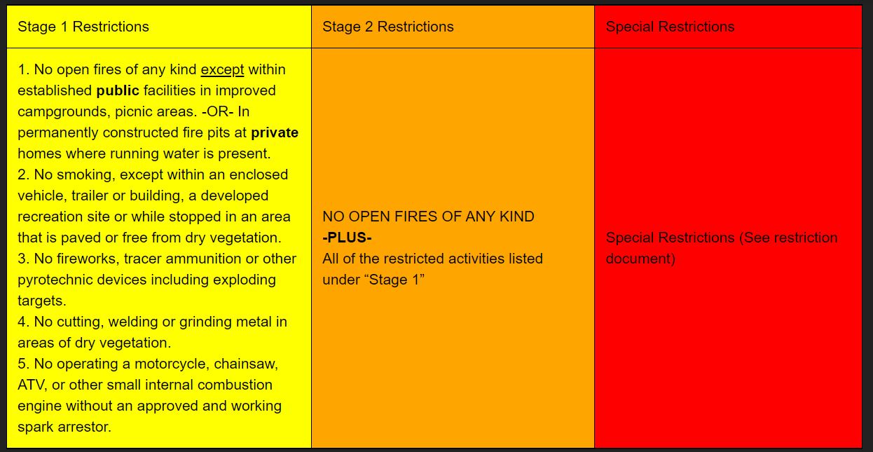
1. No open fires of any kind except within established facilities in improved campgrounds or day-use areas on public lands. -OR- In permanently constructed fire pits at permanent private dwellings served by pressurized running water.
2. Smoking, except within an enclosed vehicle, trailer or building, a developed recreation site or while stopped in an area that is paved or free from dry vegetation.
3. Cutting, welding or grinding metal in areas of dry vegetation.
4. Operating a motorcycle, chainsaw, ATV, or other small internal combustion engine without an approved and working spark arrestor.
Area Description: All state lands –AND- all unincorporated private lands within the state of Utah. This order does not affect private lands within incorporated towns or city limits. The following persons are exempted from the above prohibitions: 1. Persons with a permit or waiver issued by the Division, specifically authorizing a specified act at a specific location. A waiver does not relieve the permittee of liability if a fire does occur. 2. Any on-duty firefighter in the performance of an official duty. Any of the above acts is a violation of state law and is punishable by up to 6 months in jail and a fine of up to $1,000. These restrictions will be enforced by county law enforcement. Effective Date: 12:01 a.m., on the 10th day of June, 2021
Bennion Creek Fire Update June 16 2021
Related Incident:
Publication Type: News
Bennion Creek Fire: 8,325 acres, 17% containment. Began June 4, 2021.
A printable version of this complete update may be found at the link below under "Related Information".
Update: Containment on the Bennion Creek Fire has increased to 17%, and the fire remains at 8,325 total acres. The additional containment on the fire is shown on the spot east of Starvation Road. A printable version of today’s fire map may be found https://tinyurl.com/pjeey7kw.
Night operations on the fire went well yesterday evening. Firefighters worked to hold and secure direct and indirect line that had been completed earlier in the day. Today will be the last evening planned for nightshift operations on the fire. Tomorrow, those resources will be transitioned to daytime fire operations.
On the southwest flank of the fire, crews will work directly on the line where they are able. Crews will be inserted above Fish Creek Road to cold trail and secure perimeter. In the upper Bennion Creek drainage, crews will monitor the dozer line. In the higher elevations, they will engage and patrol line. On the northeast side of the fire, crews will patrol and mop up along Starvation Creek. The southern edge of the spot east of Starvation Road will be assessed today and make sure that there are no areas of concern. Plumbing will be set up to provide water support for firefighting efforts.
Weather: A RED FLAG WARNING is in effect for the fire through Thursday evening. A few dry showers may develop today across the mountainous terrain. These showers are anticipated to produce little to no rain and gusty and erratic outflow winds. Winds will shift this afternoon from Southwest to West to Northwest. Gusts of up to 30 mph are anticipated through the afternoon.
Resources: A total of 283 firefighters are assigned to the fire. Resources include 9 hand crews, 5 helicopters, 7 Engines, and 1 dozer.
Closures: Bennion Ridge Road, Forest Road 0008 (Bear Ridge Road), Starvation Road, and Fish Creek Trail. These closures are for public and firefighter safety.
Evacuations: The Aspen Cove subdivision has been evacuated; its status will be re-evaluated tomorrow evening.
Jurisdiction: The fire is in the jurisdiction of the Manti-La Sal National Forest, Bureau of Land Management, state and private lands. California Interagency Incident Management Team 10 is managing the fire.
###
Smoke Outlook for 616 617 NE Utah Bear Bennion Creek Fires
Related Incident:
Publication Type: News
Special Statement
Red Flag Warning in effect today until 10PM Thursday.
Fire
Currently the Bear fire is at 11,225 acres and 30% contained and the Bennion fire is at 8,325 acres and 17% contained. Crews continue to make good progress on both fires which resulted in no new starts with minimal smoke production throughout the evening. Today we will see a wind shift and possible dry lightning which could result in new starts and an increase in fire behavior which will result in more smoke production.
Smoke
Winds are predicted to change from SW to NW leading to more smoke being blown into the Helper area and Price area with good moderate air quality throughout the day. Moab will see lingering smoke from the Pack Creek fire and will be in the good to moderate ranges throughout the day. Communities North and East of the fire should see less smoke into the day and then increase in the evening and morning hours.
Other
The following groups are considered sensitive when it comes to air quality; - Children, mostly because their lungs are still developing. - Anyone with specific preexisting conditions such as asthma, COPD or heart disease. - Pregnant women. Check the most current air quality at airnow.gov