U.S. flag

An official website of the United States government

Here's how you know

Smoke Outlook for 628629 North Central AZ Rafael Fire

Related Incident:
Publication Type: News

 See attached bulletin for:
Smoke Outlook for 6/28-6/29 North Central AZ Rafael Fire
Issued at June 28, 2021 at 08:57 MDT


Rafael Fire Morning Update June 28 2021

Related Incident:
Publication Type: News

For information on evacuation status, and fire activity, there will be a virtual community meeting today at 6 p.m. on the Incident Facebook page: https://www.facebook.com/RafaelFireInfo/

Acres: 77,102, Percent Containment: 48%
Date/Time Detected: Friday, 06/18/2021 at 1927 MST
Structures Damaged/Destroyed: 0
Number of Personnel: 633
Cause: Lightning
Origin/Location: 4 miles north of Perkinsville

Today on the north side of the fire, crews will be heavily engaged in securing the fire by patrol and mop up activities.  All perimeter firing operations are substantially complete, but smoke from burning interior fuels will continue for a few days. Today smoke is expected in the Verde Valley into Prescott and as winds shift later in the day into Williams area. Heavy smoke may settle into canyon bottoms and low elevation communities in the Verde Valley over the next few nights. Smoke forecasts are available at Wildfire Smoke Forecast | ADEQ Arizona Department of Environmental Quality and https://fires.airfire.org/outlooks/NorthCentralArizona.

On the south side of the fire, aircraft will monitor the perimeter to determine if suppression action is necessary and structure protection specialists will continue monitoring values at risk to prevent damage. Firefighters are prepared for initial attack over the next few days as the probability of thunderstorms and lightning increases. As containment increases some crews and equipment are no longer needed and will be released for reassignment or rest and recuperation.

"GO” in Coconino County Sycamore Canyon and in Yavapai County, Loy Ranch. American Red Cross (ARC) activated a shelter to support those who have been evacuated due to the fire. ARC Shelter is located at Sinagua Middle School, 3950 E. Butler Ave., Flagstaff, AZ 86004.

“SET” in Coconino County, Garland Prairie South and Garland Prairie North. In Yavapai County, Grey Ranch, Windmill Ranch and Bear Mountain.

READY” in Coconino County, South of Williams, Sherwood Forest, Camp Navajo, West of I-17 south of I-40, Westwood Estates, Flagstaff Ranch (including W.L. Gore), Mountain Dell, Pine Del, Forest Highlands, Kachina Village, University Heights, Equestrian Estates, Upper Oak Creek canyon, West Fork, Lower Oak Creek Canyon and in Yavapai County, Sedona.

It’s fire season in Northern Arizona. Residents in Northern Arizona should be Ready. https://ein.az.gov/ready-set-go

Information about evacuation status can be found on the Coconino County Facebook page at: https://www.facebook.com/CoconinoCounty  and at the Yavapai County Sheriff’s Department Facebook page at: https://www.facebook.com/YavapaiCountySheriff/ 

Maps of evacuation status in Coconino County can be found at: Coconino County Situational Awareness Viewer: https://tinyurl.com/vcw4n9uj

Full forest closures are in effect on the Kaibab National Forest, Coconino National Forest, and Prescott National Forest. Kaibab National Forest – Alerts & Notices: https://www.fs.usda.gov/alerts/kaibab/alerts-notices Coconino National Forest - Alerts & Notices: https://www.fs.usda.gov/alerts/coconino/alerts-notices Prescott National Forest - Alerts & Notices: https://www.fs.usda.gov/alerts/prescott/alerts-notices/  

All Arizona State Trust lands are closed effective Friday, June 25 at 8:00 a.m. Fire Restrictions and Closures Across Arizona | Department of Forestry and Fire Management: https://tinyurl.com/3raxv63u


Evening Update for June 27 2021

Related Incident:
Publication Type: News

For information on evacuation status, and fire activity, there will be a virtual community meeting every day at 6 p.m. until further notice, on the Incident Facebook page: https://www.facebook.com/RafaelFireInfo/

Acres: 76,322, Percent Containment: 48%
Date/Time Detected: Friday, 06/18/2021 at 1927 MST
Structures Damaged/Destroyed: 0
Number of Personnel: 633
Cause: Lightning Origin/Location: 4 miles north of Perkinsville

Firefighters have completed a firing operation from White Horse Lake Recreation Site to JD Dam and west towards Wagner Hill, using forest roads as a fire break. Aerial ignitions were utilized to provide depth along roads and along the edge of Sycamore Canyon. This will create a backing fire which will limit burn severity to soils and vegetation in Sycamore Canyon.  This completes the large burning operations that were designed to halt fire progression to the north. Smoke is expected to decrease significantly from the fire in the coming days.  Smoke forecasts are available at Wildfire Smoke Forecast | ADEQ Arizona Department of Environmental Quality (azdeq.gov) and https://fires.airfire.org/outlooks/NorthCentralArizona.   Crews mopped up and patrolled along the previous days’ burnout from Turkey Butte lookout to the Boy Scout camp on the northeast edge of the fire. This operation was designed to prevent movement of the fire to the northeast toward Flagstaff, and other values at risk. Near the fire origin, crews mopped up hot spots north to Government Canyon. On the south side of the fire, helirappelers were utilized to contain a hotspot below Casner Mountain and firefighters continued hand line in Mooney Canyon, and structure protection specialists assessed protection measures for values at risk from Loy Canyon to Seven Canyons Resort. Today a BAER (Burned Area Emergency Response) team began assessing fire impacts to soils and watersheds on the west side of the fire.

Evacuation status as of 6 p.m. June 27 (Notifications are in place until status is rescinded or changed by each respective County Sheriff’s Office):

"GO” in Coconino County Sycamore Canyon and in Yavapai County, Loy Ranch. American Red Cross (ARC) activated a shelter to support those who have been evacuated due to the fire. ARC Shelter is located at Sinagua Middle School, 3950 E. Butler Ave., Flagstaff, AZ 86004.

“SET”  in Coconino County, Garland Prairie South and Garland Prairie North. In Yavapai County, Grey Ranch, Windmill Ranch and Bear Mountain.

“READY”  in Coconino County, South of Williams, Sherwood Forest, Camp Navajo, West of I-17 south of I-40, Westwood Estates, Flagstaff Ranch (including W.L. Gore), Mountain Dell, Pine Del, Forest Highlands, Kachina Village, University Heights, Equestrian Estates, Upper Oak Creek canyon, West Fork, Lower Oak Creek Canyon and in Yavapai County, Sedona.

It’s fire season in Northern Arizona. Residents in Northern Arizona should be Ready.  https://ein.az.gov/ready-set-go
Information about evacuation status can be found on the Coconino County Facebook page at: https://www.facebook.com/CoconinoCounty and at the Yavapai County Sheriff’s Department Facebook page at: https://www.facebook.com/YavapaiCountySheriff/ 

Maps of evacuation status in Coconino County can be found at: Coconino County Situational Awareness Viewer (arcgis.com)

Full forest closures are in effect on the Kaibab National Forest, Coconino National Forest, and Prescott National Forest   Coconino National Forest - Alerts & Notices (usda.gov)    Kaibab National Forest - Alerts & Notices (usda.gov). and Prescott National Forest - Alerts & Notices (usda.gov)
All Arizona State Trust lands are closed effective Friday, June 25 at 8:00 a.m. Fire Restrictions and Closures Across Arizona | Department of Forestry and Fire Management (az.gov)


Rafael Fire Morning Update June 27 2021

Related Incident:
Publication Type: News

Fire Information Public Phone Line: (928) 421-4579
Fire Information Media Phone Line: (928) 421-4983
Email: 2021.Rafael@firenet.gov
Inciweb: https://inciweb.nwcg.gov/incident/7567/
Facebook: https://www.facebook.com/RafaelFireInfo/
 Twitter: https://twitter.com/RafaelFireInfo/

Rafael Fire Morning Update – June 27, 2021

For information on evacuation status, and fire activity, there will be a virtual community meeting every day at 6 p.m. until further notice, on the Incident Facebook page: https://www.facebook.com/RafaelFireInfo/

Acres: 62,376
Percent Containment: 11%
Date/Time Detected: Friday, 06/18/2021 at 1927 MST
Structures Damaged/Destroyed: 0
Number of Personnel: 664
Cause: Lightning
Origin/Location: 4 miles north of Perkinsville

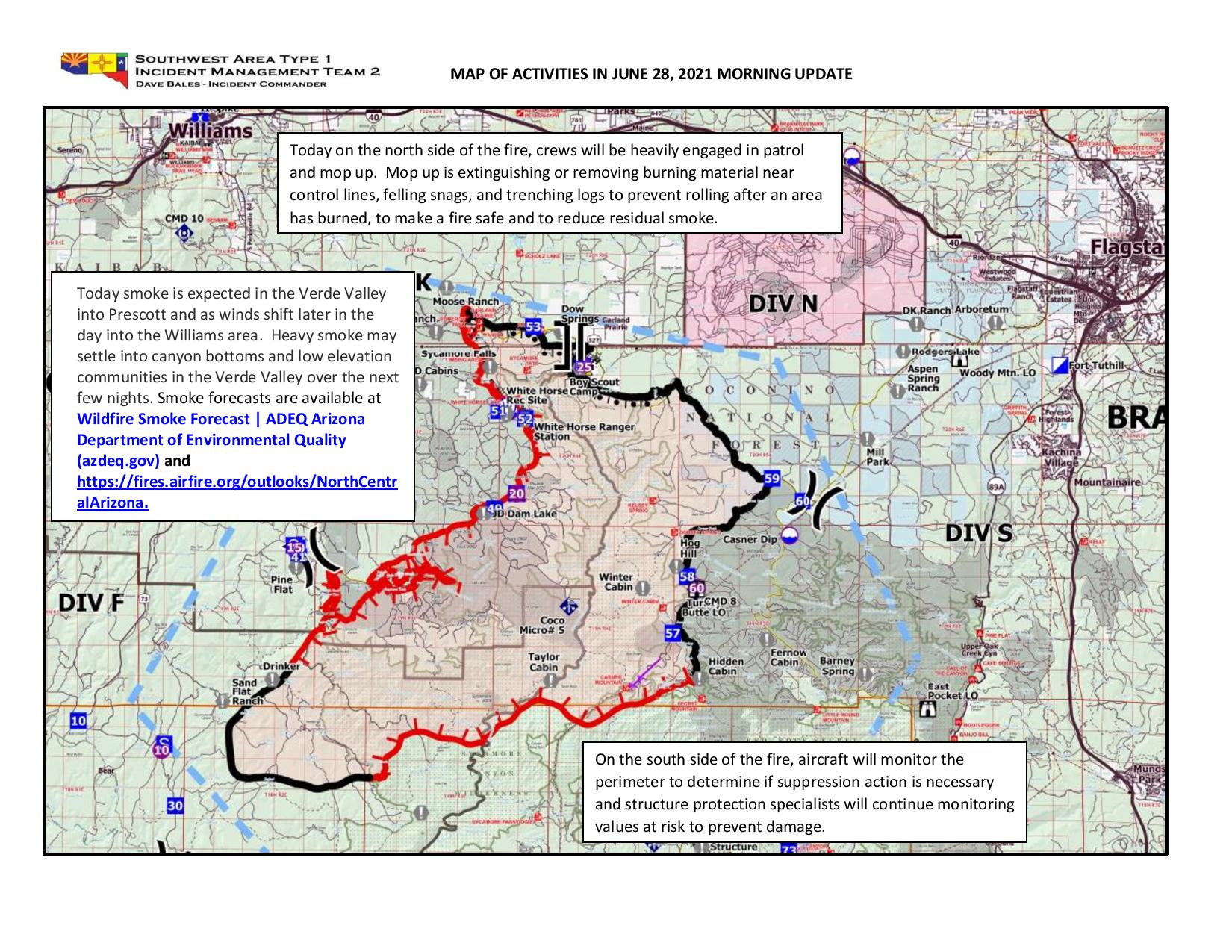
Yesterday crews finished the burnout operation, completing containment line from Turkey Butte lookout to the Boy Scout camp on the northeast edge of the fire. Today this line will be patrolled and mopped up. This operation was designed to prevent movement of the fire to the northeast toward Flagstaff, and other values at risk. Firefighters will continue a firing operation from White Horse Lake Recreation Site to JD Dam and west to Pine Flat, using forest roads as a fire break.  Near the fire origin, crews will check the fire’s edge for hot spots and mop them up north to Government Canyon. On the south side of the fire, firefighters will continue hand line in Mooney Canyon, and structure protection specialists will continue to assess values at risk from Loy Canyon to Seven Canyons Resort.  Approximately 10 miles of burning is left to contain the north end of the fire and crews will attempt to complete that operation today if weather conditions allow. Consequently, smoke is expected to be more noticeable, and may settle in low lying areas, such as Verde Valley and Prescott Valley, lifting by late morning. Smoke columns will be visible throughout the day as burning operations continue. Smoke forecasts are available at Wildfire Smoke Forecast | ADEQ Arizona Department of Environmental Quality (azdeq.gov) and https://fires.airfire.org/outlooks/NorthCentralArizona.  Today a BAER (Burned Area Emergency Response) team will begin assessing fire impacts to soils and watersheds.

Evacuation status as of 6 a.m. June 27 (Notifications are in place until status is rescinded or changed by each respective County Sheriff’s Office):

 “GO” in Coconino County Sycamore Canyon and in Yavapai County, Loy Ranch. American Red Cross (ARC) activated a shelter to support those who have been evacuated due to the fire. ARC Shelter is located at Sinagua Middle School, 3950 E. Butler Ave., Flagstaff, AZ 86004.

“SET” – in Coconino County, Garland Prairie South and Garland Prairie North. In Yavapai County, Grey Ranch, Windmill Ranch and Bear Mountain.

“READY” -– in Coconino County, South of Williams, Sherwood Forest, Camp Navajo, West of I-17 south of 1-40, Westwood Estates, Flagstaff Ranch (including W.L. Gore), Mountain Dell, Pine Del, Forest Highlands, Kachina Village, University Heights, Equestrian Estates, Upper Oak Creek canyon, West Fork, Lower Oak Creek canyon  and in Yavapai County, Sedona.

It’s fire season in Northern Arizona. All residents in Northern Arizona should be in Ready status.

Information about evacuation status can be found on the Coconino County Facebook page at: https://www.facebook.com/CoconinoCounty and at the Yavapai County Sheriff’s Department Facebook page at: https://www.facebook.com/YavapaiCountySheriff/  Maps of evacuation status in Coconino County can be found at: Coconino County Situational Awareness Viewer (arcgis.com)

Full forest closures are in effect on the Kaibab National Forest, Coconino National Forest, and Prescott National Forest. Kaibab National Forest - Alerts & Notices (usda.gov). Coconino National Forest - Alerts & Notices (usda.gov) Prescott National Forest - Alerts & Notices (usda.gov)

All Arizona State Trust lands are closed effective Friday, June 25 at 8:00 a.m. Fire Restrictions and Closures Across Arizona | Department of Forestry and Fire Management (az.gov)

###


Rafael Fire Evening Update June 26 2021

Related Incident:
Publication Type: News

Fire Information Public Phone Line: (928) 421-4579
Fire Information Media Phone Line: (928) 421-4983
Email: 2021.Rafael@firenet.gov
Inciweb: https://inciweb.nwcg.gov/incident/7567/
Facebook: https://www.facebook.com/RafaelFireInfo/
Twitter: https://twitter.com/RafaelFireInfo/


Rafael Fire Evening Update – June 26, 2021

For information on evacuation status, and fire activity, there will be a virtual community meeting every day at 6 p.m. until further notice, on the Incident Facebook page: https://www.facebook.com/RafaelFireInfo/

Acres: 53,664
Percent Containment: 11%
Date/Time Detected: Friday, 06/18/2021 at 1927 MST
Structures Damaged/Destroyed: 0
Number of Personnel: 664
Cause: Lightning
Origin/Location: 4 miles north of Perkinsville

Crews completed the firing operation today down FR 538 to the edge of Sycamore Canyon. Crews mopped up and patrolled yesterday’s firing operation from the Boy Scout Camp to the intersection of FR 527 and FR 538. Firefighters continued yesterday’s burnout, bringing fire south from the Sycamore Falls Climbing Area to White Horse Lake and south toward JD Dam and continued the line preparation from Pine Flat to Sycamore Point. All of the burning activity is designed to stop fire growth towards the values at risk in the I-40 corridor from Williams to Flagstaff and is also the safest way for our firefighters to suppress the fire that is burning in the steep canyon country of Sycamore Canyon. Crews were able to construct handline at the edge of the Mogollon Rim in Mooney Canyon to check fire spread towards Sedona. Aerial ignition with a helicopter and Unmanned Aerial Vehicle (drone) were used to back fire down into Sycamore Canyon to minimize fire effects to soils and vegetation on the steep slopes of Sycamore Canyon.  Burning operations are expected to continue for the next few days as long as weather conditions allow.  Consequently, smoke is expected to be more noticeable the next few days. Smoke may settle in low lying areas, such as Verde and Prescott Valleys, and will lift by late morning. Smoke columns will be visible throughout the day as burning operations continue. Smoke forecasts are available at Wildfire Smoke Forecast | ADEQ Arizona Department of Environmental Quality (azdeq.gov) and https://fires.airfire.org/outlooks/NorthCentralArizona

Evacuation status as of 6 p.m. June 25 (Notifications are in place until status is rescinded or changed by each respective County Sheriff’s Office):

“GO” in Coconino County, areas around Sycamore Canyon and South of Forest Service Road 535 off FS 231 (Sycamore Canyon) and in Yavapai County, some rural ranches in the area of North FSR 525 and Bill Grey Road, West of Sedona (Loy Ranch). A shelter for evacuees is set up at Sinagua Middle School at 3950 E. Butler in Flagstaff.

“SET” – in Coconino County, Garland Prairie South, Garland Prairie (including North Pine Aire Estates). In Yavapai County, Bill Grey Road (Grey Ranch), FS Road 525 (Windmill Ranch), and FS Road 152C and Bear Mountain Road (Bear Mountain).

“READY”
-– in Coconino County, Camp Navajo, all areas south of 1-40, west of I-17 including the following neighborhoods: Westwood Estates, Flagstaff Ranch (including W.L. Gore), Pine Del, Forest Highlands, Kachina Village, University Heights, Mountain del, and Equestrian Estates and in Yavapai County, the areas north of AZ-89A in West Sedona and north of AZ-89A in Uptown Sedona (Sedona).

It’s fire season in Northern Arizona. All residents in Northern Arizona should be in Ready status.

Information about evacuation status can be found on the Coconino County Facebook page at: https://www.facebook.com/CoconinoCounty and at the Yavapai County Sheriff’s Department Facebook page at: https://www.facebook.com/YavapaiCountySheriff/  Maps of evacuation status in Coconino County can be found at: Coconino County Situational Awareness Viewer (arcgis.com)

Full forest closures are in effect on the Kaibab National Forest, Coconino National Forest, and Prescott National Forest. Kaibab National Forest - Alerts & Notices (usda.gov). Coconino National Forest - Alerts & Notices (usda.gov) Prescott National Forest - Alerts & Notices (usda.gov)

All Arizona State Trust lands are closed effective Friday, June 25 at 8:00 a.m. Fire Restrictions and Closures Across Arizona | Department of Forestry and Fire Management (az.gov)

###        

South Garland Prairie GO Order Downgraded to SET

Related Incident:
Publication Type: Announcement
The Coconino County Sheriff’s Office is pleased to announce that we are lifting the “GO” evacuation order of the residents living in the South Garland Prairie neighborhood. The Southwest Incident Management Team that is managing the Rafael Fire has determined that the status and condition of the fire at this time is no longer an imminent threat to the South Garland Prairie neighborhood and has recommended allowing residents back into their homes.

Residents returning to the South Garland Prairie will return to a “SET” status. The Incident Management Team and the Sheriff’s Office reminds residents that the conditions and status of the fire could change at any time resulting the return of a “GO-evacuation” status. We will continue to closely monitor the situation and will communicate any change in status as soon as possible.

The Sheriff’s Office will begin the re-entry of the South Garland Prairie residents at 5:00 PM today, June 26, 2021. Evacuated residents are instructed to report in person to deputies staged at the roadblocks on Forest Service Road 141 either east or west of the evacuated area. Residents will be required to show identification verifying their address before they are allowed entry.

Only residents will be allowed back into the evacuated area.  The Coconino County Sheriff’s Office will continue to patrol the area.  All members of the public are reminded to be mindful and cautious of the increase in traffic in firefighting apparatus and closure of the forest in and around the fire area. 
We thank you for your patience during this difficult time. 

Continue to monitor CCSO, Coconino County, Rafael Fire social media and official news releases for additional information.

Fuels and Fire Behavior Advisory 616 630 SW Area Predictive Services

Related Incident:
Publication Type: News

See attached: Related Information below 

Fuels and Fire Behavior Advisory
Southwest Area – Arizona & Far Western New Mexico
Valid: June 16th – 30th, 2021

Subject: Severe to exceptional drought accompanied by near record heat & very dry conditions is causing explosive fire behavior potential in available fuels. 

Issued By: Southwest Area Predictive Services and Decision Support


Smoke Outlook for 626627 North Central AZ Rafael Fire

Related Incident:
Publication Type: News

See attached bulletin for:
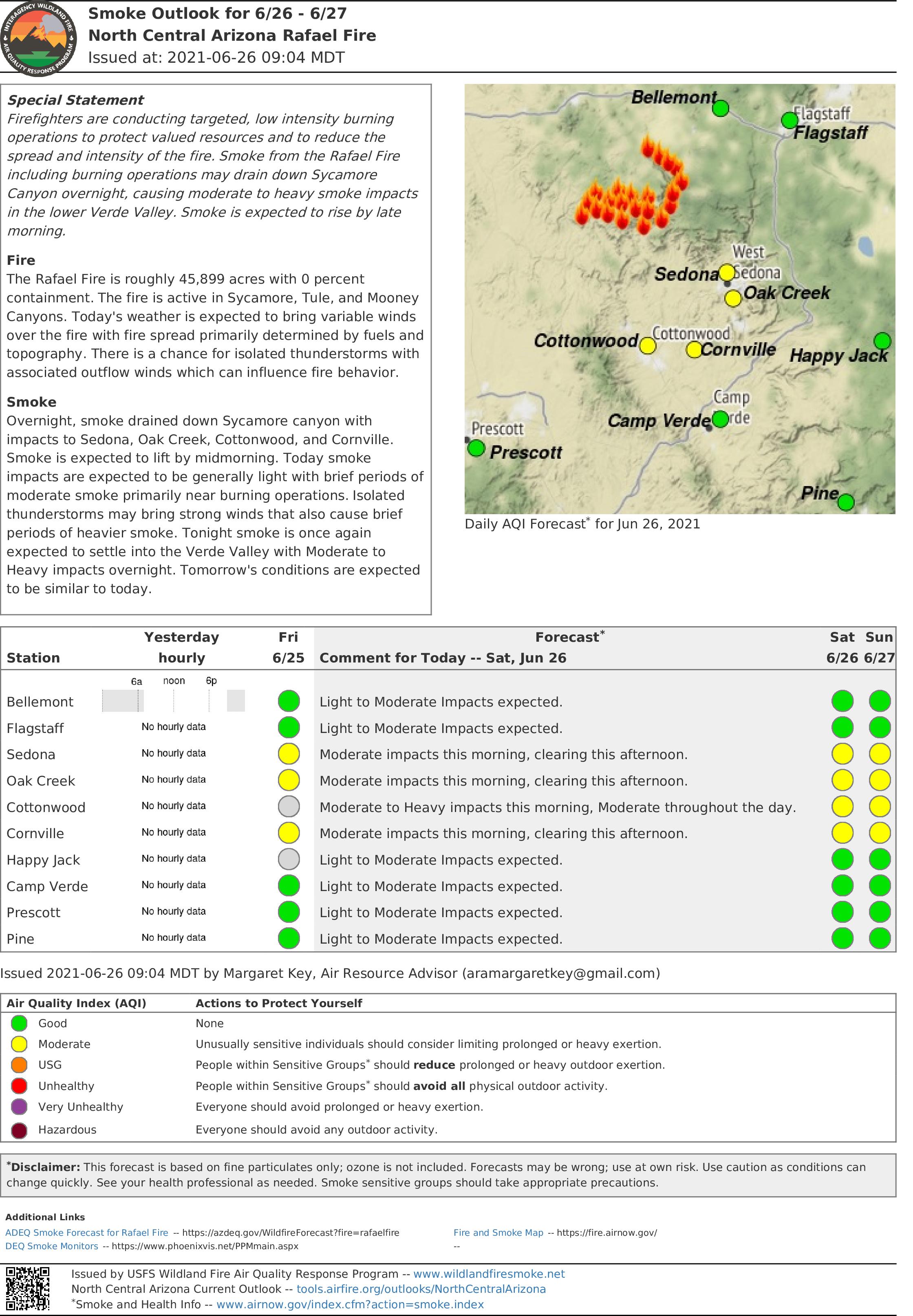
Smoke Outlook for 6/26-6/27 North Central AZ Rafael Fire
Issued at June 26, 2021 at 09:04 MDT


Rafael Fire Morning Update June 26 2021

Related Incident:
Publication Type: News
Fire Information Public Phone Line: (928) 421-4579

Fire Information Media Phone Line: (928) 421-4983

Email: 2021.Rafael@firenet.gov

InciWeb: https://inciweb.nwcg.gov/incident/7567/

Facebook: https://www.facebook.com/RafaelFireInfo/

Twitter: https://twitter.com/RafaelFireInfo/

Rafael Fire Morning Update – June 26, 2021

For information on evacuation status, and fire activity, there will be a virtual community meeting every day at 6 p.m. until further notice, on the Incident Facebook page: https://www.facebook.com/RafaelFireInfo/

Acres:
45,899

Percent Containment: 0%

Date/Time Detected: Friday, 06/18/2021 at 1927 MST

Structures Damaged/Destroyed: 0

Number of Personnel: 553

Cause:
Lightning

Origin/Location: 4 miles north of Perkinsville

Today on the Kaibab National Forest, firefighters will continue yesterday’s burnout, bringing fire south from the Sycamore Falls Climbing Area to White Horse Lake, with support of an unmanned aerial vehicle (drone). Crews will continue line preparation from Pine Flat to Sycamore Point along FR 105, in anticipation of a firing operation. On the Coconino National Forest, crews will mop up and patrol yesterday’s firing operation from the Boy Scout Camp to the intersection of FR 527 and FR 538. Crews will continue the firing operation today down FR 538 to the edge of Sycamore Canyon. This activity is designed to stop fire growth towards the values at risk in the I-40 corridor from Williams to Flagstaff.  This afternoon, crews will begin to backfire down into Sycamore Canyon by aerial ignition with helicopters and drones. This activity is designed to minimize fire effects to soils and vegetation on the steep slopes of Sycamore Canyon.  Burning operations are expected to continue for the next few days as long as weather conditions allow.  Smoke is expected to be more noticeable the next few days due to burnout operations. Smoke may settle in low lying areas, such as Verde and Prescott Valleys, and will lift by late morning. Smoke columns will be visible throughout the day as burning operations continue. Smoke forecasts are available at Wildfire Smoke Forecast | ADEQ Arizona Department of Environmental Quality (azdeq.gov) .

Evacuation status as of 6 a.m. June 25 (Notifications are in place until status is rescinded or changed by each respective County Sheriff’s Office):

 “GO” in Coconino County, areas around Sycamore Canyon and South of Forest Service Road 535 off FS 231 (Sycamore Canyon) and Garland Prairie South. In Yavapai County, some rural ranches in the area of North FSR 525 and Bill Grey Road, West of Sedona (Loy Ranch). A shelter for evacuees is set up at Sinagua Middle School at 3950 E. Butler in Flagstaff.

“SET”
– in Coconino County, areas around Camp Navajo, Garland Prairie North, Pine Aire Estates and residents in between. In Yavapai County, Bill Grey Road (Grey Ranch), FS Road 525 (Windmill Ranch), and FS Road 152C and Bear Mountain Road (Bear Mountain).

“READY”
-– in Coconino County, all areas south of 1-40, west of I-17 including the following neighborhoods: Westwood Estates, Flagstaff Ranch (including W.L. Gore), Pine Del, Forest Highlands, Kachina Village, University Heights, Mountain del, and Equestrian Estates and in Yavapai County, the areas north of AZ-89A in West Sedona and north of AZ-89A in Uptown Sedona have been placed on “Ready” status.
It’s fire season in Northern Arizona. All residents in Northern Arizona should be in Ready status.

Information about evacuation status can be found on the Coconino County Facebook page at: https://www.facebook.com/CoconinoCounty

Maps of evacuation status in Coconino County can be found at: Coconino County Situational Awareness Viewer (arcgis.com)

Full forest closures are in effect on the Kaibab National Forest, Coconino National Forest, and Prescott National Forest. Kaibab National Forest - Alerts & Notices (usda.gov). Coconino National Forest - Alerts & Notices (usda.gov) Prescott National Forest - Alerts & Notices (usda.gov)

All Arizona State Trust lands are closed effective Friday, June 25 at 8:00 a.m. Fire Restrictions and Closures Across Arizona | Department of Forestry and Fire Management (az.gov)

###      


Rafael Fire Evening Update June 25 2021

Related Incident:
Publication Type: News

Fire Information Public Phone Line: (928) 421-4579

Fire Information Media Phone Line: (928) 421-4983

Email: 2021.Rafael@firenet.gov

InciWeb: https://inciweb.nwcg.gov/incident/7567/ Facebook: https://www.facebook.com/RafaelFireInfo/ Twitter: https://twitter.com/RafaelFireInfo/  

Rafael Fire Evening Update – June 25, 2021

For information on evacuation status, and fire activity, there will be a virtual community meeting every day at 6 p.m. until further notice, on the Incident Facebook page: https://www.facebook.com/RafaelFireInfo/


  Acres: 43,612 Percent Containment: 0% Date/Time Detected: Friday, 06/18/2021 at 1927 MST Structures Damaged/Destroyed: 0 Number of Personnel: 553 Cause: Lightning Origin/Location: 4 miles north of Perkinsville     TaTaking advantage of favorable weather conditions, today crews continued where they left off yesterday afternoon and began a firing operation at approximately 9 a.m. along road systems on west side of Sycamore Canyon on the Coconino National Forest.  On the Kaibab National Forest, crews continued to connect forest roads from Pine Flat to Sycamore Point to be used as holding lines in preparation for burnout operations.  Burning operations are expected to continue for the next few days as long as weather conditions allow. On the south side near Mooney Canyon, firefighters will continue to monitor the retardant line and scout and identify control lines in preparation for future suppression operations. Smoke is expected to be more noticeable the next few days due to the hotter drier weather that will increase fire activity in Sycamore Canyon combined with smoke from burnout operations. Smoke forecasts are available at Wildfire Smoke Forecast | ADEQ Arizona Department of Environmental Quality (azdeq.gov) .
  Evacuation status as of 6 a.m. June 25 (Notifications are in place until status is rescinded or changed by each respective County Sheriff’s Office): “GO” in Coconino County, areas around Sycamore Canyon and South of Forest Service Road 535 off FS 231 (Sycamore Canyon) and Garland Prairie South. In Yavapai County, some rural ranches in the area of North FSR 525 and Bill Grey Road, West of Sedona (Loy Ranch).  A shelter for evacuees is set up at Sinagua Middle School at 3950 E. Butler in Flagstaff. “SET” – in Coconino County, areas around Camp Navajo, Garland Prairie North, Pine Aire Estates and residents in between. In Yavapai County, Bill Grey Road (Grey Ranch), FS Road 525 (Windmill Ranch), and FS Road 152C and Bear Mountain Road (Bear Mountain). “READY” -– in Coconino County, all areas south of 1-40, west of I-17 including the following neighborhoods: Westwood Estates, Flagstaff Ranch (including W.L. Gore), Pine Del, Forest Highlands, Kachina Village, University Heights, Mountain del, and Equestrian Estates and in Yavapai County, the areas north of AZ-89A in West Sedona and north of AZ-89A in Uptown Sedona have been placed on “Ready” status. Notifications can change rapidly. Residents in areas affected by the fire should remain vigilant and be prepared to evacuate. Evacuation notifications are issued when danger is imminent and life threatening. Information about evacuation status can be found on the Coconino County Facebook page at:   https://www.facebook.com/CoconinoCounty  Maps of evacuation status in Coconino County can be found at: Coconino County Situational Awareness Viewer (arcgis.com)       Full forest closures are in effect on the Kaibab National Forest, Coconino National Forest, and Prescott National ForestKaibab National Forest - Alerts & Notices (usda.gov). Coconino National Forest - Alerts & Notices (usda.gov) Prescott National Forest - Alerts & Notices (usda.gov) All Arizona State Trust lands are closed effective Friday, June 25 at 8:00 a.m.  Fire Restrictions and Closures Across Arizona | Department of Forestry and Fire Management (az.gov)

###

Subscribe to