
Rough Patch Complex and Jack Fire Daily Update Sept 25
Related Incident:
Publication Type: News
September 25, 2021
Fire Information: 541-482-1331
E-mail: 2021.jack@firenet.gov
Incident Summary: Firefighters successfully used direct tactics and helicopter water drops to suppress hot spots on the north end of the complex yesterday. Helicopters were also used on the southeast corner to support direct fire line construction. On many areas around the perimeter of the complex, crews conducted suppression repair operations, including processing logs, chipping limbs, and removing debris from control lines. Firefighters also removed firefighting equipment, pumps and hoses no longer needed. This work is being emphasized ahead of predicted cool and wet weather, which is expected to make some areas of the fire line temporarily inaccessible. Damp fuels limited fire behavior to creeping and smoldering.
Today, warm and dry weather will continue to reduce fuel moisture and increase the chance for limited active fire behavior and some smoke production. All perimeters will be monitored by air, and helicopters remain available for suppression assistance if needed.
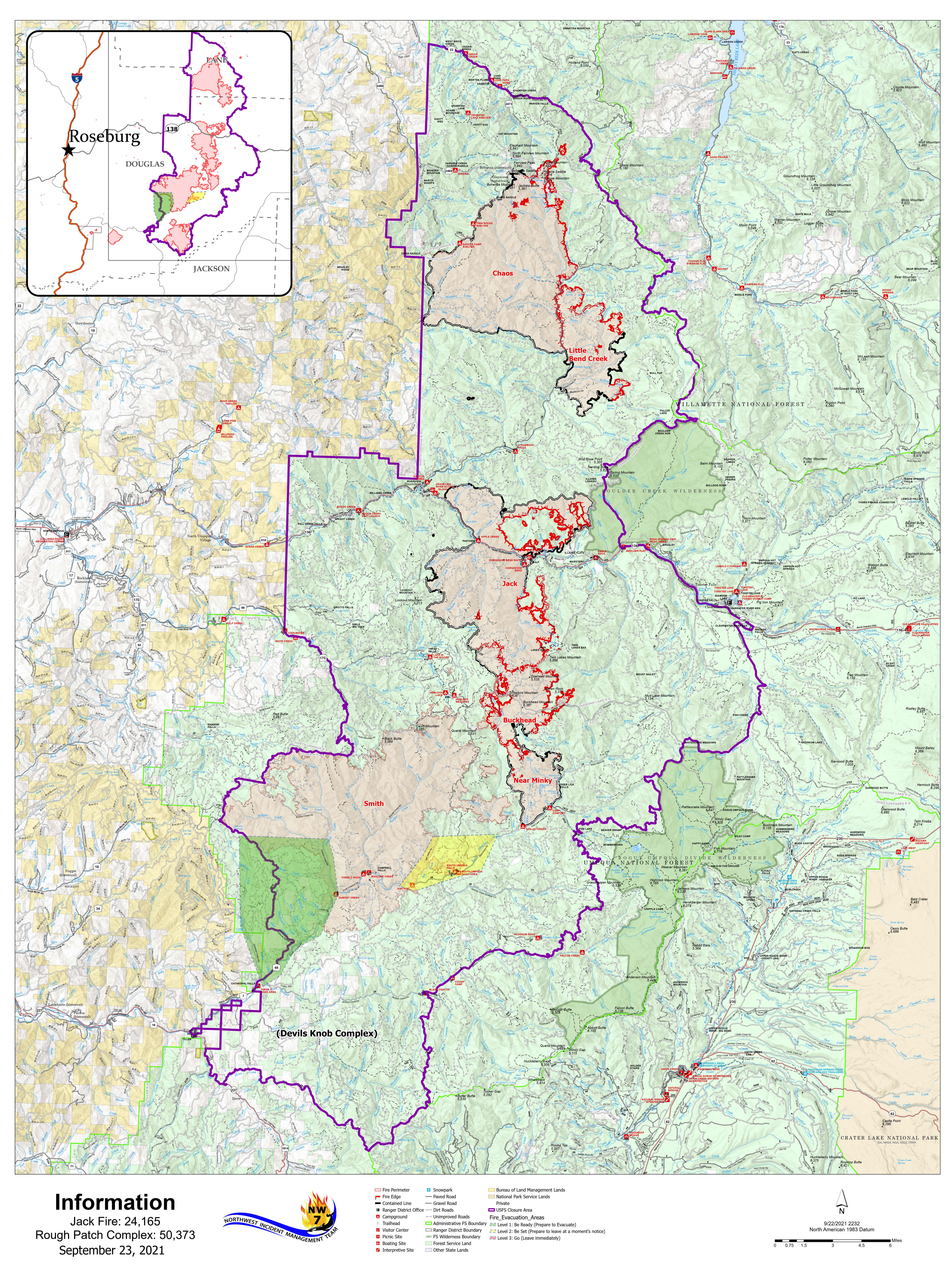
Chaos and Little Bend Fires: The Chaos Fire is 28,850 acres, and the Little Bend Fire is 9,429 acres. Repair work continued on the 28 Road to chip debris and process and haul trees cleared for fire line construction. Fallers worked to cut trees damaged by the fire that are likely to fall onto roads.
Jack Fire: The Jack Fire is 24,165 acres and is 58% contained. Crews performed road preparation and chipping work to improve indirect lines on the fire's east side.
Near Minky and Buckhead Fires: The Near Minky Fire is 4,869 acres, with no significant fire activity reported. The Buckhead Fire is 7,237 acres. Fire crews used helicopter water bucket drops to check the movement of the Buckhead Fire north of the 2715 Road. Firefighters also scouted the area for opportunities for direct attack. You can find information on the nearby Smith Fire on the Devil's Knob Complex Inciweb page: https://inciweb.nwcg.gov/incident/7771/.
Evacuations and Closures: Evacuations and closures information is available at https://inciweb.nwcg.gov/incident/closures/7758/.
- The Umpqua and Willamette National Forests have temporarily closed areas of both forests due to the Jack Fire, Rough Patch Complex, and Devil's Knob Complex.
- Amended BLM Roseburg District fire closure: BLM Road 24-1-26 (Francis Creek) from the junction with BLM Road 25-1E-31 (Canton Creek Road) North to the Roseburg District Boundary in Township 24 South Range 1 West Section 1 will remain closed.
- Highway 138 between Roseburg and Diamond Lake remains open. Expect short delays for hazard tree removal operations east of Glide. Slow down and be alert.
Smoke: Warmer and drier conditions will contribute to increased smoke in the vicinity of the fires.
Fire season is not over! Please do all you can to prevent wildland fires.
Smoke Outlook 924 925
Related Incident:
Publication Type: Announcement
Fire and Weather:
The Rough Patch Complex remains at 50,376 acres as does the Devils Knob at 69,941 acres. The complexes are 42% and 59% contained respectively. Today will be the warmest and driest day since last weekend’s rains. The wind will also be an added factor increasing the fire danger level to “elevated”. However, there is still little likelihood of anything more than isolated hot spots growing within the fire perimeter.
Smoke:
Today and tomorrow the air quality in SW Oregon will likely not be negatively affected by smoke generated from the Rough Patch and Devils Knob Complex Fires. However, Sunday the air quality index may be compromised by smoke from wildfires in northern California.
Note
This is the last Smoke Outlook for the South Oregon Cascades for these incidents.
Rough Patch Complex and Jack Fire Daily Update Sept 24 2021
Related Incident:
Publication Type: News
September 24, 2021
Fire Information: 541-482-1331
E-mail: 2021.jack@firenet.gov
Incident Summary: Firefighters were successful using direct tactics to suppress spots on the north end of the complex yesterday. Areas along the eastern perimeter were also inspected for opportunities to use direct tactics on persistent hotspots. Crews conducted suppression repair operations, including processing logs, chipping limbs, and removing debris from drainage areas. Fire behavior was limited to creeping and smoldering. Today, warm and dry weather will reduce fuel moisture and increase the chance for limited active fire behavior. Monitor and patrol by air resources will be available all day.
Chaos and Little Bend Fires: The Chaos Fire is 28,841 acres, and Little Bend Fire is 9,417 acres. Firefighters secured several spot fires on the north and northeast sides of the Chaos Fire along Noon Day Ridge. Crews mopped up and gridded the fire's perimeter near the 2212 Road. Helicopters performed water bucket drops to cool hot spots on the edges of both fires.
Jack Fire: The Jack Fire is 24,165 acres and is 55% contained. Crews performed road preparation and chipping work to further improve indirect lines on the east side of the fire.
Near Minky and Buckhead Fires: The Near Minky Fire is 4,869 acres with no significant fire activity reported. The Buckhead Fire is 7,237 acres. Fire crews used helicopter water bucket drops to check movement of the Buckhead Fire north of the 2715 Road. Crews also scouted the area for opportunities for direct attack. You can find information on the nearby Smith Fire on the Devil's Knob Complex Inciweb page: https://inciweb.nwcg.gov/incident/7771/.
Evacuations and Closures: Evacuations and closures information is available at https://inciweb.nwcg.gov/incident/closures/7758/.
- Umpqua and Willamette National Forests have temporarily closed areas of both forests due to the Jack Fire, Rough Patch Complex, and Devil's Knob Complex.
- Amended BLM Roseburg District fire closure: BLM road 24-1-26 (Francis Creek) from the junction with BLM road 25-1E-31 (Canton Creek Road) North to the Roseburg District Boundary in Township 24 South Range 1 West Section 1 will remain closed.
- Highway 138 between Roseburg and Diamond Lake remains open. Expect short delays for hazard tree removal operations east of Glide. Slow down and be alert.
Smoke: Warmer and drier conditions will contribute to increased smoke in the vicinity of the fires.
Fire season is not over! Please do all you can to prevent wildland fires.
Rough Patch and Jack Fire Daily Update Sept 23 2021
Related Incident:
Publication Type: News
September 23, 2021
Fire Information: 541-482-1331
E-mail: 2021.jack@firenet.gov
Incident Summary: Northwest Team 7, Jason Loomis Incident Commander, assumed command of the Rough Patch Complex and Jack Fires today at 6 a.m.
Fuels across the complex are drying with this week's warmer and drier weather; however, fire behavior yesterday was limited to creeping and smoldering. Fire managers from the incoming incident management team inspected the fire area and began making plans for suppression activities going forward.
Chaos and Little Bend Fires: The Chaos Fire is 28,841 acres, and the Little Bend Fire is 9,417 acres. Firefighters secured several spot fires on the north and northeast sides of the Chaos Fire along the 2460 Road. Crews also worked to secure the fire’s perimeter along Noon Day Ridge from the 2212 Road. On the Little Bend Fire, helicopters performed water bucket drops to cool hot spots on the eastern edge of the fire.
Jack and Buckhead Fires: The Jack Fire is 24,1665 acres, and the Buckhead Fire is 7,237 acres. Fire crews used helicopter water bucket drops to check the movement of the Buckhead Fire north of the 2715 Road. Firefighters performed road preparation and chipping work on indirect lines on the east side of the complex. You can find information on the nearby Smith Fire at the Devil's Knob Complex Inciweb page: https://inciweb.nwcg.gov/incident/7771/.
Near Minky Fire: The Near Minky Fire is at 4,869 acres. No significant fire activity has been reported.
Evacuations and Closures: Evacuations and closures are available at https://inciweb.nwcg.gov/incident/closures/7758/.
Umpqua and Willamette National Forests have temporarily closed areas of both forests due to the Jack Fire, Rough Patch Complex, and Devil's Knob Complex.
Amended BLM Roseburg District fire closure: BLM road 24-1-26 (Francis Creek) from the junction with BLM road 25-1E-31 (Canton Creek Road) North to the Roseburg District Boundary in Township 24 South Range 1 West Section 1 will remain closed.
Highway 138 between Roseburg and Diamond remains open. Expect short delays for hazard tree removal operations east of Glide. Slow down and be alert.
Fire season is not over! Please do all you can to prevent wildland fires.
Smoke Outlook 923 924
Related Incident:
Publication Type: Announcement
Fire and Weather:
The Rough Patch Fire is 50,376 acres and the Devils Knob is 69,941 acres. The fires are 42% and 51% contained respectively. Though the forest continues to dry out from the weekend rains, the wind speed, air temperature and humidity will not be conducive to active fire spread however, hot spots will continue to smolder and burn within the fire containment areas.
Smoke:
Little smoke will be generated from the Rough Patch and Devils Knob fire areas. With northerly winds today there should be little smoke influence from the fires in California.
Smoke Outlook 922 923
Related Incident:
Publication Type: Announcement
Fire and Weather:
Rough Patch and Jack Fire Update Sept 22 2021
Related Incident:
Publication Type: News
Incident Summary: There was little to no fire growth on the Rough Patch Complex yesterday. Warmer temperatures occurred across the Complex, and fuel moistures decreased. As a result, both smoldering and smoke generation increased throughout the day. Fire crews made good progress securing spot fire activity on the north and northeast side of Chaos Fire. Suppression repair work took place on the east side of the Complex. Warm and breezy weather is forecast later this week.
Today will be the final day for Great Basin Team 2. The Pacific Northwest Type 2 Team 7, Jason Loomis Incident Commander, will assume command of the Rough Patch Jack Complex tomorrow at 6am.
Chaos and Little Bend Fires: The Chaos Fire is 28,841 acres, and the Little Bend Fire is 9,417 acres. Firefighters secured several spot fires on the northeast corner of the Chaos Fire along the 2460 road. On the Little Bend Fire, suppression repair teams worked to keep soils in place and remove debris from drainages areas. Crews also improved containment lines along the 3831 road.
Jack and Buckhead Fires: The Jack Fire is 24,1665 acres, and the Buckhead Fire is 7,237 acres. Fire crews used helicopter water bucket drops to check the movement of the Buckhead Fire north of the 2715 road. Widespread suppression repair work occurred on the south and west edges of these fires. Information on the nearby Smith Fire can be found at the Devil’s Knob Complex Inciweb page https://inciweb.nwcg.gov/incident/7771/.
Near Minky Fire: The Near Minky Fire is at 4,869 acres. No significant fire activity was reported while containment lines are holding well.
Evacuations and Closures: Evacuations and closures are found at https://inciweb.nwcg.gov/incident/closures/7758/.
· Umpqua and Willamette National Forests have temporarily closed areas of both forests due to the Jack Fire, Rough Patch Complex, and Devil's Knob Complex.
· Amended BLM Roseburg District fire closure: BLM road 24-1-26 (Francis Creek) from the junction with BLM road 25-1E-31 (Canton Creek Road) North to the Roseburg District Boundary in Township 24 South Range 1 West Section 1 will remain closed.
· Highway 138 between Roseburg and Diamond remains open. Expect short delays for hazard tree removal operations east of Glide. Slow down and be alert.Smoke Outlook 921 922
Related Incident:
Publication Type: Announcement
Fire and Weather:
Rough Patch and Jack Fire Daily Update Sept 21 2021
Related Incident:
Publication Type: News
Incident Summary: On Monday morning, Lane County Sheriff's Office rescinded the level 3 evacuation order on the Chaos Fire for the Bohemia Mining District. There are currently no evacuation notifications for the Rough Patch Complex or Jack Fire. Additional containment was added on the east side of the Little Bend Fire boosting the Rough Patch Complex containment to 41%. Fuel moistures are still high from this weekend's rain event. Firefighters observed some isolated smoldering and smoke across the complex; however, there was no surface spread. Aerial reconnaissance along the northern portion of the Chaos Fire confirmed that no structures were damaged during last week’s fire growth. The weather will be warm and breezy this week; however, fire growth should be minimal in the coming days.
Chaos and Little Bend Fires: The Chaos Fire is 28,748 acres, and the Little Bend Fire is 9,408 acres. Crews began installing hose lays to secure spot fires that crossed over the 2460 road on the east side of the Bohemia Mining District. Firefighters developed a plan to secure the fire growth on Noonday Ridge north of the 2460 road. On the Little Bend Fire, crews removed hazard trees and conducted suppression repair to keep soils in place and remove debris from drainages areas.
Jack and Buckhead Fires: The Jack Fire is 24,165 acres, and the Buckhead Fire is 7,237 acres. On the southeast edge of the Buckhead Fire, crews plan to use helicopter bucket drops to check the spot fire north of the 2715 road if the fire becomes active as fuels dry. The improved air quality will allow for helicopters to fly as needed this week. Information on the nearby Smith Fire can be found at the Devil’s Knob Complex Inciweb page https://inciweb.nwcg.gov/incident/7771/.
Near Minky Fire: The Near Minky Fire is at 4,869 acres. All containment lines are holding well, and there is no significant fire activity.
Evacuations and Closures: Evacuations and closures are found at https://inciweb.nwcg.gov/incident/closures/7758/.
· Umpqua and Willamette National Forests have temporarily closed areas of both forests due to the Jack Fire, Rough Patch Complex, and Devil's Knob Complex.
· Amended BLM Roseburg District fire closure: BLM road 24-1-26 (Francis Creek) from the junction with BLM road 25-1E-31 (Canton Creek Road) North to the Roseburg District Boundary in Township 24 South Range 1 West Section 1 will remain closed.
· Highway 138 between Roseburg and Diamond remains open. Expect short delays for hazard tree removal operations east of Glide. Slow down and be alert.
Level 3 Evacuation Lifted for Bohemia Mining District in Lane County
Related Incident:
Publication Type: Announcement
On Monday morning, Lane County Sheriff's Office rescinded the level 3 (go now) evacuation order on the Chaos Fire for the Bohemia Mining District. There are currently no evacuation notifications for the fires associated with the Rough Patch Complex or Jack Fire.
https://lanecounty.org/news/rough_patch_complex_fire_information