
Fire Update 7721 AM
Related Incident:
Publication Type: News
Cheney, WA – Overnight crews worked to extinguish hot spots and secure perimeter lines. Today firefighters are watching the weather closely and prepared to address any new activity on and around the fire. The focus is to work on snags (trees that have burned and are ready to fall), fire line strengthening, and gridding the fire for any additional hot spots. This important work will help containment numbers to rise. Current containment on the fire is 20%.
Level 1 & 2 evacuation orders remain in place. Due to the evacuation levels being lowered roads that were previously closed are only open to local residents. If you do not live in the area, please adhere to the road closures and stay clear. For current evacuation orders please see Spokane County Department of Emergency Management (DEM) Facebook page.
There are approximately 210 firefighters from all over the state working on the fire and there have been no injuries or structures lost.
The Red Cross shelter at Medical Lake High School is now closed. Spokane County Fairgrounds is still open for livestock. While we appreciate the outpouring of generosity, there are no current needs for donations for the firefighting efforts. Individuals who want to donate items should contact their local food pantries or local charities.
The Andrus Fire started Monday July 5th at approximately 11:30 am near Andrus Rd. The fire spread quickly due to low relative humidity and unseasonably dry conditions. Firefighters from Fire District 3, 4, 8, 9, 10, Airway Heights Fire, Spokane City Fire, Spokane Valley Fire, Lincoln County, Department of Natural Resources (DNR) and numerous other agencies were critical in slowing the spread of the fire. Agencies from around the state are now on scene to work on mop up operations. The collaborative efforts and teamwork between the agencies were critical in slowing fire spread and working to mitigate the incident to its completion.
Fire Update 7621 800 PM
Related Incident:
Publication Type: News
Cheney, WA – The Andrus Fire started Monday morning at approximately 11:30 am near Andrus Rd. The fire spread quickly due to low relative humidity and unseasonably dry conditions. After a more accurate assessment of the perimeter today the acreage is approximately 225, with 20% containment. Firefighters from Fire District 3, 4, 8, 9, 10, Airway Heights Fire, Spokane City Fire, Spokane Valley Fire, Lincoln County, Department of Natural Resources (DNR) and numerous other agencies were critical in slowing the spread of the fire. The collaborative efforts and teamwork between the agencies were critical in slowing fire spread and protecting lives and property.
Crews were able to get a good assessment of the fire today and continue working on structure assessments, securing fire lines and gridding for hot spots. Due to the progress, evacuation levels have decreased one level in each evacuation zone. If you were a level 3 you are now bumped to a level 2 and so on. Due to the evacuation levels being lowered roads that were previously closed are only open to local residents. If you do not live in the area, please adhere to the road closures and stay clear. For current evacuation orders please see Spokane County Department of Emergency Management (DEM) Facebook page. Fire crews will continue their work through the night looking for hot spots and further securing the containment line. There are approximately 188 firefighters from all over the state working on the fire. There have been no injuries or structures lost.
The Red Cross is coordinating a shelter at Medical Lake High School for evacuees and Spokane County Fairgrounds is open for livestock. Citizen and firefighter safety is our number one priority.
Due to the size and resources that are needed the fire district was able to request State Mobilization resources. Northeast Washington Interagency Type 3 IMT Team 2 has assumed command of the incident as of 10:00 pm on July 5th. They will work in collaboration with local agencies to manage the incident.
Fire Update 7621 1030 am
Related Incident:
Publication Type: News
Cheney, WA – The Andrus Fire started Monday morning at approximately 11:30 am near Andrus Rd. The fire spread quickly due to low relative humidity and unseasonably dry conditions. The fire is currently estimated at 300 acres with 0% containment at this time Firefighters from Fire District 3, 4, 8, 9, 10, Airway Heights Fire, Spokane City Fire, Spokane Valley Fire, Lincoln County, Department of Natural Resources (DNR) and numerous other agencies were critical in slowing the spread of the fire. The collaborative efforts and teamwork between the agencies are critical to protecting lives and property.
Firefighting efforts today will focus on structure protection, containment lines and getting a good assessment of the fire. There are approximately 150 firefighters on the ground and air support is scheduled to continue throughout the day. Crews will continue to work through the day and overnight and expect to make additional progress. There have been no injuries or structures lost. Level 3 evacuation orders and road closures are still in place. For current evacuation orders please see Spokane County Department of Emergency Management (DEM) Facebook page.
The Red Cross is coordinating a shelter at Medical Lake High School for evacuees and Spokane County Fairgrounds is open for livestock. Citizen and firefighter safety is our number one priority. Citizens are asked to remain clear of the fire area and adhere to the road closures.
Due to the size and resources that are needed the fire district was able to request state mobilization resources. Northeast Washington Interagency Type 3 IMT Team 2 has assumed command of the incident as of 10:00 pm on July 5th. They will work in collaboration with local agencies to manage the incident. There are no firefighter injuries reported at this time.
BAER Teams Release Rough Patch Complex and Jack Fire Soil Burn Severity Map
Related Incident:
Publication Type: News
Forest Service
Umpqua National Forest
2900 Northwest Stewart Parkway
Roseburg, OR 97471
(541) 957-3200
https://www.facebook.com/UmpquaNat ionalForest
Twitter @UmpquaNF
News Release
FOR IMMEDIATE RELEASE: October 3, 2021
Umpqua National Forest BAER Info: Joe Blanchard
Email: Joseph.blanchard@usda.gov
BAER teams working on post-fire assessment of the Rough Patch Complex, Jack Fire, and Devils Knob Complex release Soil Burn Severity maps.
Roseburg, OR – Two Forest Service Burned Area Emergency Response (BAER) teams have been established to assess the Rough Patch Complex, Jack Fire, and Devils Knob Complex for post-fire changed watershed conditions and threats to USFS critical values.
The Burned Area Emergency Response (BAER) program is designed to identify and manage potential risks to resources on National Forest System lands and reduce these threats through appropriate emergency measures to protect human life and safety, property, and critical natural and cultural resources. BAER is an emergency program for stabilization work that involves time-critical activities to be completed before the first damaging event to prevent damage or loss of those critical values from changes caused by the post-fire environment.
The BAER teams utilized satellite imagery and specialist data to analyze and produce a map of each fire incident that shows the levels of soil burn severity on the watersheds. This is the first step in assessing potential watershed impacts from wildfires to any NFS values that may be at-risk from potential increased flooding, sedimentation, debris flows and rockslides. BAER teams produce a report that describes threats associated with the burned area’s post-fire conditions along with recommended emergency stabilization measures and actions. BAER emergency response efforts are focused on the protection of human life, safety and property, as well as critical cultural and natural resource values such as the water quality of streams and wetlands on NFS lands.
The Soil Burn Severity maps for the three fire incidents have been finalized, and less than one percent of any of the fires resulted in high soil burn severity. Overall, the maps depict a mixed severity burn of moderate, low, and very low/unburned severity.
The BAER team resource specialists then use the Soil Burn Severity maps to complete rapid assessments that evaluate the burned area to identify watersheds having increased potential for post-fire flooding, sediment flows, falling trees, and rockslides. BAER teams typically consist of scientists and specialists including hydrologists, geologists, soil scientists, road engineers, botanists, fisheries biologists, wildlife biologists, recreation specialists, archeologists and geographic information specialists. BAER teams collect data during their burned area surveys to analyze through GIS and computer models and present their findings along with recommended BAER emergency response actions in a BAER assessment report.
The BAER Teams on the Rough Patch Complex, Jack Fire, and Devils Knob complex are currently in the process of assessing the potential threats, and risk of damage or loss to NFS critical values, as well as formulating emergency treatment recommendations to protect those identified NFS critical values from damage or loss. This information will be presented in an assessment report that identifies immediate and emergency actions needed to address post-fire risks to human life and safety, property, cultural and critical natural resources.
# # #
USDA is an equal opportunity provider, employer, and lender.
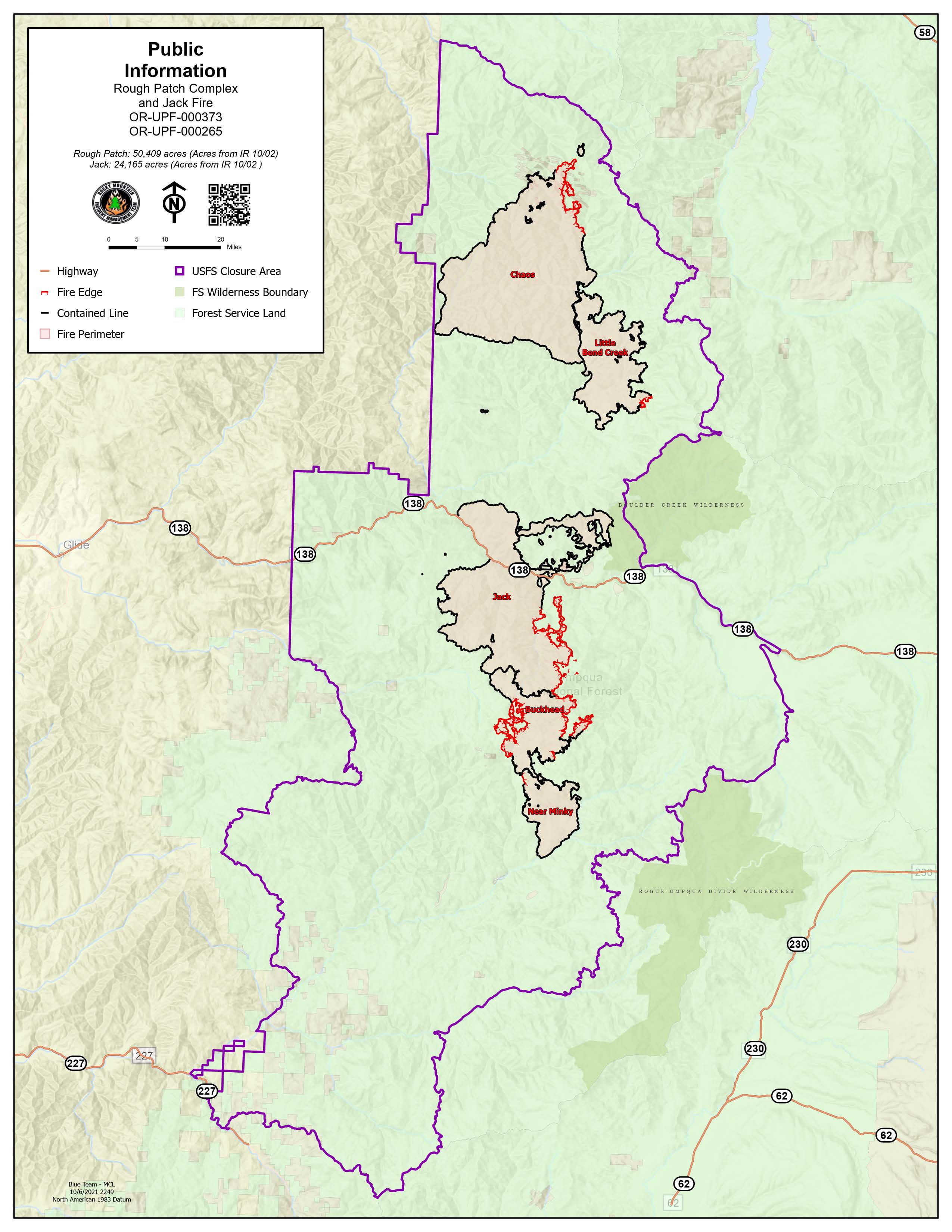
Rough Patch Complex and Jack Fire Daily Fact Sheet Oct 9 2021
Related Incident:
Publication Type: News
Acres: 24,165
Containment: 83%
Personnel: 4
Current Situation
- Yesterday, the Umpqua and Willamette National Forests released a revised closure order allowing access to some parts of the Forest that were previously closed. A link to the new order and maps is below.
- The fire is displaying minimal activity, however there are still safety concerns with the crews, trucks, large equipment, and damaged roadways. The Blue Team and the Forest Service are working together to clean things up so life can return to normal.
- There will continue to be a decrease of firefighter presence as deconstruction of the Incident Command Post will occurs over the next few days. However, there will be an influx of personnel working in and around the fires’ perimeter. Many of the heavy equipment operators, drivers, and contractors are local and their work is critical in helping restore the Forest.
- Workers are making great progress in suppression repair operations. But heavier traffic continues on Highway 138 as more equipment will be hauling chips and debris from suppression repair out of the fire area.
- This will be the last updated Daily Facts Sheet. Information will continue to be shared on Inciweb and Facebook.
Fire Conditions and Weather
- Surface fuels are wet and will only support minor smoldering or creeping of fire. Heavy fuels will continue to hold heat, but fire spread remains minimal.
- Today, will be mostly sunny skies with slightly warmer temperatures. Clouds will start to move in overnight along with cooler temperatures for Sunday.
Closures:
- The Umpqua and Willamette National Forests and BLM Roseburg District have temporarily closed areas of both Forests due to the Jack Fire, Rough Patch Complex, and Devils Knob Complex. View the closure area orders and maps on https://inciweb.nwcg.gov/incident/closures/7758/
Oct 8 Reduced Forest Closure
Related Incident:
Publication Type: Closures
UNITED STATES DEPARTMENT OF AGRICULTURE
FOREST SERVICE
UMPQUA & WILLAMETTE NATIONAL FORESTS
Roseburg and Springfield, OR
ORDER NO. 06-15-00-21-453
EMERGENCY FIRE AREA CLOSURE
ROUGH PATCH, JACK, ARCHIE CREEK, DEVIL’S KNOB FIRE AREAS
Pursuant to 16 U.S.C. § 551 and 36 CFR § 261.50(a) and (b), the following acts are prohibited upon roads, trails, and general forest areas within the Umpqua National Forest and Willamette National Forest as described below and shown in Exhibit A. This Order will be effective beginning October 8, 2021, and ending May 9, 2022, unless rescinded sooner.
PROHIBITIONS:
1. Being on the road. [36 CFR § 261.54(e)]
2. Going into or being upon an area closed for the protection of public health or safety. [36 CFR § 261.52(e)]
3. Being on a trail. [36 CFR § 261.55(a)]
CLOSURE AREA:
Starting at the confluence of Highway 138E and Rattlesnake Creek in T26S R2E Section 13, then following Rattlesnake Creek to its northernmost headwaters in T25 1/2 S R2E Section 35, then Northwest to the intersection of Forest Service Road (FSR) 4760-105 and Forest Service Trail (FST) 1535, following FST 1535 Northeast to FSR 3810-360, following FSR 3810-360 Northeast to FSR 3810, following FSR 3810 Northeast to FSR 5851, following FSR 5851 North to FST 1506, following FST 1506 North to FSR 5850, following FSR 5850 North to FSR 2213, following FSR 2213 Northwest to FSR 2212-767, following FSR 2212-767 Northwest to FSR 2212, Following FSR 2212 West to FSR 2460, Following FSR 2460 West to FSR 23, Following FSR 23 South to the Umpqua National Forest boundary, following the Umpqua National Forest boundary Southwest to Highway 138E, following Highway 138E to FSR 4711, following FSR 4711 South to FSR 2703, following FSR 2703 West to FSR 2700-111, following FSR 2700-111 Southeast to Taft Creek, following Taft Creek South to FSR 27, following FSR West to FSR 2719, following FSR South to FSR 2719-180, following FSR 2719-180 West to FSR 2792, following FSR 2792 Southwest to FSR 2792-817, following FSR 2792-817 South to FSR 2810, following FSR 2810 Southeast to County Road 46 (South Umpqua Road), following County Road 46 Southwest to County Road 1 (Tiller Trail Highway), following County Road 1 Southeast to FSR 1610, following FSR 1610 Southeast to FSR 31, following FSR 31 West to FSR 2925, following FSR 2925 North to FSR 29, following FSR 29 Northeast to FSR 2921, following FSR 2921 North to FSR 2921-200, following FSR 2980-200 North to FSR 2980-100, following FSR 2921-100 North to FSR 2921-400, following FSR 2924-400 North to FSR 2924, following FSR 2924 North to FSR 29, following FSR 29 East to FSR 2838 Northeast to FSR 2823, following FSR 2823 Northeast to FSR 28, following FSR 28 North to Highway 138E back to the point of origin at the confluence of Highway 138E and Rattlesnake Creek in T26S R2E Section 13.
This closure applies to all National Forest Systems Roads and Trails within the described closure area.
For other roads, trails, and lands please check with the appropriate jurisdiction.
ADDITIONAL CLOSURES:
FSR 27 is closed from White Creek Campground to FSR 2719
FSR 2715-950 is closed from the junction with FSR 2715-980 to the junction with FSR 2715-955
Canton Creek Campground
Musick Guard Station
Cover Campground
EXCEPTIONS TO FOREST CLOSURE:
The North Umpqua River
Canton Creek Road (FSR 23) is open from the Junction with FSR 38 and CR 249 to the Forest boundary
FSR 4711 is open through the closure area
Steamboat Ball Field Group Site
Gravel Bin Boat Launch
Island Campground
Horseshoe Bend Campground and Boat Launch
Eagle Rock Campground
EXEMPTIONS:
Pursuant to 36 CFR § 261.50(e), the following persons are exempt from this order:
1. Persons with Forest Service Permit No. FS-7700-48 (Permit for Use of Roads, Trails, or Areas Restricted by Regulation or Order), specifically exempting them from this Order.
2. Any Federal, State, or local officer, or member of any organized rescue or fire fighting force in the performance of an official duty.
This prohibition is in addition to the general prohibitions in 36 C.F.R. Part 261, Subpart A.
Violations of this prohibition are punishable by a fine of not more than $5,000 for an individual or $10,000 for an organization, or imprisonment for not more than 6 months, or both (16 U.S.C. § 551; 18 U.S.C. §§ 3551, 3559, 3571, and 3581).
Executed in Roseburg and Springfield, Oregon, October 8, 2021.
Jacob Winn
Deputy Forest Supervisor Umpqua National Forest
10/8/2021
Dave Warnack
Forest Supervisor Willamette National Forest
10/8/2021
This Order supersedes Closure Order No. 06-15-02-21-449.
Rough Patch Complex and Jack Fire Daily Fact Sheet Oct 8 2021
Related Incident:
Publication Type: News
Acres: 24,165
Containment: 83%
Personnel: 4
Current Situation
- Hand crews and heavy equipment such as dozers, excavators, chippers, and various other machines continue to work diligently on suppression repair operations. This will result in roads being open faster, safer longer and better for forest recovery.
- Slash and other woody debris are being processed into chips at landing sites and then removed. This process allows for easier removal of the debris from the fire area and Forest. Removing the slash piles will aid in further mitigation of wildfires in the future. These actions help employ local workers and businesses and reduce the burden on local communities.
- There has been an influx of personnel this week as large equipment, drivers, operators, and contractors are arriving to help your community return to normal.
- Please be aware of heavier traffic on Highway 138 as more equipment will be hauling chips and debris from suppression repair out of the fire area.
Fire Conditions and Weather
- Heavy fuels will continue to burn where they are sheltered from rain. The likelihood of fire spread is very minimal. There might be smoke from this fire into winter.
- Temperatures will be slightly cooler than yesterday with the passage of a weak cold front. There will be rain and drizzle throughout the day.
- Temperatures rebound briefly on Saturday with mostly sunny skies. Another strong cold front arrives Sunday morning. Scattered rain showers, snow at highest elevations, will develop post-frontal and persist into Monday morning.
Closures:
- The Umpqua and Willamette National Forests and BLM Roseburg District have temporarily closed areas of both Forests due to the Jack Fire, Rough Patch Complex, and Devils Knob Complex. View the closure area orders and maps on https://inciweb.nwcg.gov/incident/closures/7758/.
- The fire is no longer the biggest threat, now it is the workers, trucks, and damaged roadways. Teams and the forest are trying to clean things up so life can return to normal.
Rough Patch Complex and Jack Fire Daily Fact Sheet Oct 7 2021
Related Incident:
Publication Type: News
Acres: 24,165
Containment: 83%
Personnel: 4
Current Situation
- Loaded dump trucks will be hauling chips down to Glide. Please be aware of heavier traffic on Highway 138.
- Crews are canvassing the fire area and retrieving equipment from suppression work.
- While conditions allow, an average of eight to ten miles of repair is being completed daily.
- Road 23 has hand crews repairing dozer line, roads and installing water bars to prevent erosion.
- There has been an influx of personnel this week as large equipment, drivers, operators, and contractors are arriving to help with the suppression repair.
Fire Conditions and Weather
- Favorable weather and successful suppression action has reduced fire behavior to isolated smoldering in heavy fuels.
- Continued cool temperatures for today but a few degrees warmer than yesterday. Mostly sunny skies except for some early fog in the valleys. Winds will be light out of the west.
- Cooler temperatures and moisture will continue through the week with more precipitation arriving around Sunday.
Closures:
- The Umpqua and Willamette National Forests and BLM Roseburg District have temporarily closed areas of both Forests due to the Jack Fire, Rough Patch Complex, and Devils Knob Complex. View the closure area orders and maps on https://inciweb.nwcg.gov/incident/closures/7758/.
- Managing agencies are evaluating the area closure surrounding the fires, with the intent to restore public access to more areas as soon as safely possible. Unstable roads and slopes, fire-weakened trees, rock fall, and firefighter traffic continue to pose risks to the public. Please respect the closure while we work towards restoring access to your public lands.
Rough Patch Complex and Jack Fire Daily Fact Sheet Oct 6 2021
Related Incident:
Publication Type: News
Acres: 24,165
Containment: 83%
Personnel: 4
Current Situation
- Large logs will continue to smolder and burn where they are protected in the understory from the precipitation that has fallen on the fire.
- Suppression related repair work on the 5850 Road with heavy equipment continues. These actions include processing logs, removing slash and repairing roadways.
- Crews are actively chipping slash on the 3821 Road, removing debris from the ditches and roads to prevent erosion.
- With the relocation of the large horizontal grinder, repair work has sped up and become more efficient. 42.6 miles of repair work has been completed.
- Chipping operation in the Johnson Meadow area will be completed today and crews will progress south.
- On the west side of Rough Patch, near 2358 Road, hand crews are repairing dozer line where the terrain is too steep for heavy equipment.
Fire Conditions and Weather
- Last night the fire and burned areas received a dusting of snow with 3/10ths of an inch of precipitation.
- Cool, damp weather will keep fire behavior at a minimum.
- Cooler temperatures and moisture will continue through the week.
Closures:
- The Umpqua and Willamette National Forests and BLM Roseburg District have temporarily closed areas of both Forests due to the Jack Fire, Rough Patch Complex, and Devils Knob Complex. View the closure area orders and maps on https://inciweb.nwcg.gov/incident/closures/7758/.
- Managing agencies are evaluating the area closure surrounding the fires, with the intent to restore public access to more areas as soon as safely possible. Unstable roads and slopes, fire-weakened trees, rock fall, and firefighter traffic continue to pose risks to the public. Please respect the closure while we work towards restoring access to your public lands.
Rough Patch Complex and Jack Fire Daily Fact Sheet
Related Incident:
Publication Type: News
· Crews are removing slash and weakened trees from the fire area and fire’s perimeter. Great progress has been made but over 185 miles of suppression repair work remains.
· Firefighters will continue to monitor fire activity in the uncontrolled areas as isolated stumps, logs, and deep duff will hold heat.
· A Burned Area Emergency Response (BAER) Team, made up of natural and cultural resource experts are surveying the burned areas. These experts so far have determined that overall, less than one percent of any of the fires resulted in high soil burn severity. Overall, the maps depict a mixed severity burn of moderate, low, and very low/unburned severity. View the maps at https://inciweb.nwcg.gov/incident/maps/7758/
· A Forest closure area remains in the Rough Patch Complex and Jack Fire areas. Please respect these closures as equipment and firefighters are working along roads in the fire area.
Fire Conditions and Weather
· A cold front will arrive in the afternoon bringing cooler temperatures and scattered showers. Ridgetop winds will become stronger with gusts up to 25 mph. There is potential for snow in elevations over 4,500 feet.
· The cooler temperatures and moisture will remain the trend over the next few days.
Closures:
· The Umpqua and Willamette National Forests and BLM Roseburg District have temporarily closed areas of both Forests due to the Jack Fire, Rough Patch Complex, and Devils Knob Complex. View the closure area orders and maps on https://inciweb.nwcg.gov/incident/closures/7758/.
· Managing agencies are evaluating the area closure surrounding the fires, with the intent to restore public access to more areas as soon as safely possible. Unstable roads and slopes, fire-weakened trees, rock fall, and firefighter traffic continue to pose risks to the public. Please respect the closure while we work towards restoring access to your public lands.Fire Facts
Location:
Approximately 303 personnel, including:
Temporary Flight Restriction:
Remember: If You Fly, We Can’t! For details on the TFR, see https://tfr.faa.gov/
Management: