
West Preacher Fires Update 09 06 2024
Related Incident: 2024 - West Fire - TNF2024 - Preacher Fire - TNF
Publication Type: News
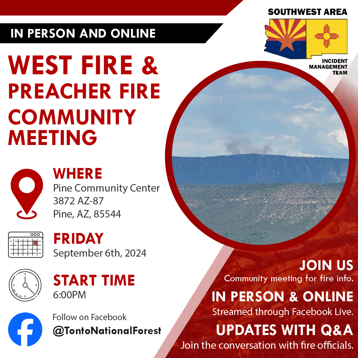
Public Meeting scheduled for tonight in Pine, AZ
Highlights: The Tonto National Forest and SW Area Incident Management Team will be holding a public meeting on Friday, September 6, 2024 at 6 p.m. at the Pine Community Center 3872 AZ-87, Pine, AZ, 85544. The public meeting will be in person and streamed through the Tonto National Forest Facebook page: @TontoNationalForest. If by chance we run into problems streaming, the meeting will be recorded and uploaded to view later.
Operations:
West Fire - 28 Acres: Removal of fuels along Milk Ranch Road continues to be the focus of the work. Today masticators will continue preparing this road to be defensible and hold the fire within the identified containment area. Additional engines and crews are removing dead trees along roads to prevent them from catching fire or falling onto roads. A crew is also constructing firelines from Bray Creek Ranch north to the Rim. In Camp Geronimo vegetation is being cut back from roads and structures are being prepared with hose and sprinklers. Dozers and equipment will continue improving existing fuel breaks just west of Pine.
Preacher Fire - 3 Acre: Yesterday, crews finished preparing firelines north of the fire. The southern lines are nearly complete. Crews from the northside of the Preacher Fire will relocate to the southern side to help accomplish the remaining preparation. Engines continue to patrol the lines.
Both fires are being managed under a confine/contain strategy with the goal of reintroducing fire into a fire dependent ecosystem. The intended result of managing naturally caused fires are to reduce hazardous fuels, encourage the growth of native forage, improve range conditions, increase species diversity, protect and improve wildlife habitat, improve watershed conditions and restore ecological balance. The total planning areas for the West Fire includes 16,700 acres, for Preacher Fire 3,200 acres. This will decrease unnaturally high accumulations of fuels and the potential for future fires to burn with unnaturally high severity, aligning with the Forest Service Wildfire Crisis Strategy: https://www.fs.usda.gov/managing-land/wildfire-crisis.
Weather: Sunny and hot conditions persist with temperatures in the middle to upper 80’s. The relative humidity has fallen to around 20% and the wind is terrain driven at speeds less than 10 mph with gusts to 15 mph. The overall weather pattern will not change through the end of the week with hot and dry conditions. Low shower and thunderstorm chances are anticipated to return to the region on the weekend.
Safety: With the weekend upon us, we want to remind local and visitors to use caution with the additional fire traffic in and around the communities of Payson, Pine, Strawberry, Tonto Village, Star Valley, and Whispering Pines.
Closure: The Tonto National Forest has issued a closure for land surrounding the West Fire. https://inciweb.wildfire.gov/incident-publication/aztnf-2024-west-fire-tnf/us-forest-service-closure-order-for-west-fire-09-04-2024
Smoke: Smoke from the West and Preacher Fires may be visible in the surrounding areas for many days. Smoke will be heavier in the mornings as it settles into the lower elevations and will lift as temperatures increase. As temperatures increase the volume of smoke may increase due to the drying and ignition of available fuels. Smoke-sensitive individuals and people with respiratory problems or heart disease are encouraged to take precautionary measures. Learn more about smoke impacts on the. https://azdeq.gov/wildfire-faqs
For the latest news and information about the Tonto National Forest, follow along on Facebook @TontoNationalForest, ‘X’ (formerly Twitter) @TontoForest or Instagram @tontonationalforest and on the Tonto National Forest website: https://www.fs.usda.gov/tonto
Williams Mine Fire Update 09 06 2024
Related Incident: Williams Mine Fire-GPNF
Publication Type: News
Williams Mine Fire Update for Friday, September 6, 2024
A Red Flag Warning has been issued for the Williams Mine Fire area. This warning will remain in effect until 11:00 p.m. today. The warning was issued due to expected wind, low relative humidity, and unstable conditions. There is also a Heat Advisory through 9:00 p.m. Saturday.
Fire activity has increased the last couple of days and nights as fuels have dried out and become more receptive to burning. The winds from the east have helped the fire move west from the Morrison Creek drainage up Crofton Ridge. This and other burning areas produced ample smoke yesterday. During the afternoon, the smoke began to drift downslope into the valleys, obscuring Mt. Adams and producing poor air quality.
There have been large unburned islands inside the fire perimeter. The largest pocket, between Morrison Creek and Crofton Ridge, plus some smaller areas burned yesterday, pushed by the wind and backing into it. Most of these unburned pockets are expected to be cleaned up by the fire sooner or later. Since they are surrounded by areas that have already had the fire consume most of the fuels, these interior flareups are of little concern to fire personnel. These areas are monitored, but rarely merit any suppression actions.
A helicopter continues to drop water on the eastern edge of the fire in the Mt. Adams Wilderness, trying to slow this edge’s progression to the east. The objective is to keep the fire west of South Climb Trail and off of the Yakama Reservation.
FS Rd 23 is still closed while fire personnel complete work on it as a contingency line. Excavators and dump trucks are on the road moving limbs and brush and clearing ditches. A hand crew will be working along the road, cutting brush that machines couldn’t reach safely.
SAFETY AND CLOSURES:
A Red Flag Warning indicates that conditions may be favorable for rapid fire spread which may threaten life and property. Use extra caution with potential ignition sources, especially in grassy areas.
The Confederated Tribes and Bands of the Yakama Nation, Tract D Recreation Area is currently closed, please see Yakama Tract D Road Closure for more information. FS Rd 23 south of FS Rd 90 is still CLOSED to the public due to fire suppression activity. Takhlakh Lake is still closed. The revised closure for the Mt. Adams Wilderness and FS Rd 23 closure can be found at Williams Mine Fire: Area and Road Closure. The Pacific Crest Trail (PCT) is closed from the PCT's intersection with FS Rd 23 to Potato Hill. The current area closure spans the entire Mt. Adams Wilderness.
Willamette Complex South Daily Update for Friday Sept 6th 202409 06 2024
Related Incident: Willamette Complex Fires - South
Publication Type: News
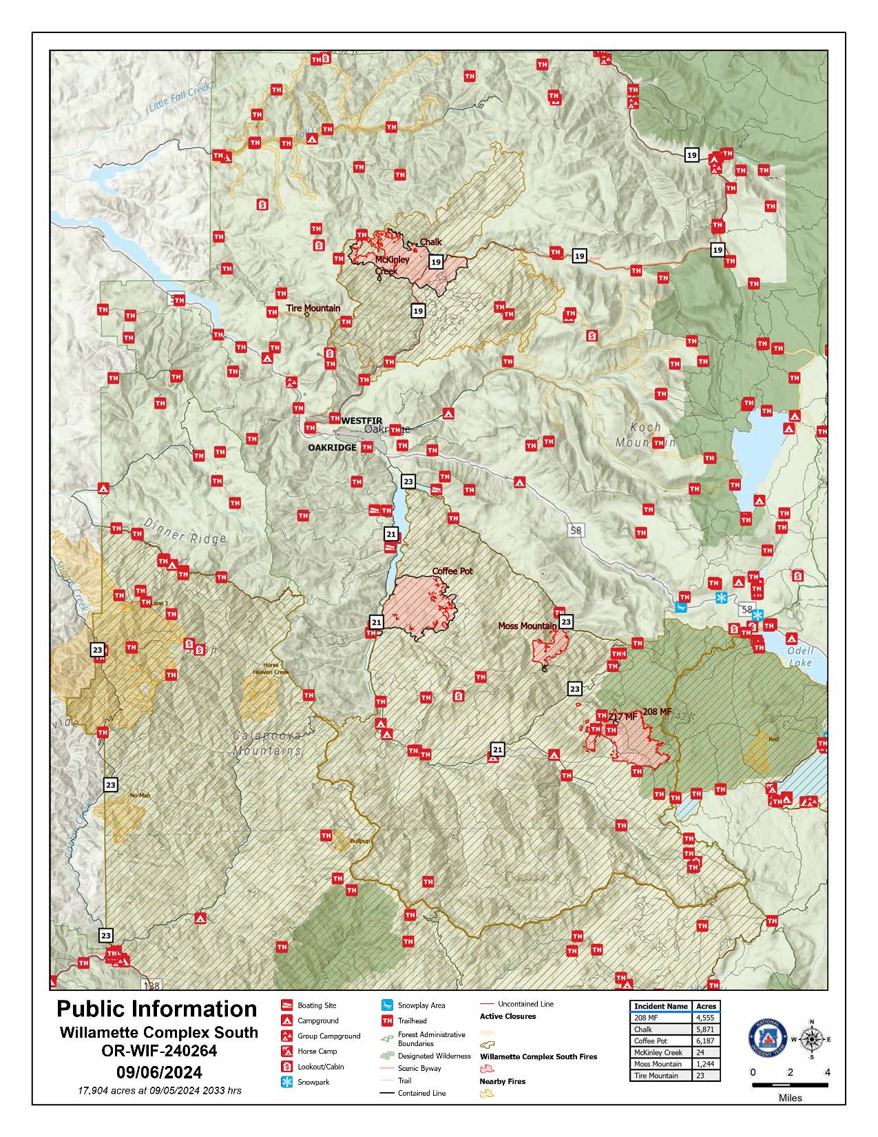
Willamette Complex South Update
Chalk, Coffeepot, McKinley, Moss Mountain, Tire Mountain, 208, and 217 Fires
Online: https://inciweb.wildfire.gov/incident-information/orwif-willamette-complex- fires-south
Facebook: https://www.facebook.com/WillametteComplexFires/
Email: 2024.willamettecomplex@firenet.gov Information Line: 541-208-1742
Friday, September 6, 2024 Fire Cause: Lightning
Total Willamette Complex South Personnel: 619
Total Willamette Complex South Acres: 15,446
Resources: 2 Type 1 Hotshot crews, 7 Type 2 crews, 2 Type 2 initial attack crews, 3 helicopters, 14 engines, 4 dozers, 72 heavy equipment (masticators, skid steers, feller bunchers, etc.)
Community Meeting Saturday, September 7th, 2024, at the Middle Fork Ranger Station at 6:30 PM PST. The meeting will be in person with a virtual option on the fire’s Facebook; the recording will be posted thereafter.
Summary East winds in the overnight hours further accelerated fire activity. High temperatures and low relative humidity today will further the burning of heavy fuels. The Red Flag Warning for the area was extended into this evening due to ongoing critical fire weather and a potential for afternoon lightening. The incident's number one priority for the day will be supporting local resources with initial attack with the potential for new starts. Firefighters continue to progress with containment efforts including patrolling, mop-up, holding existing line, and developing line.
Chalk Fire (5,871 acres, 86% containment) Progress towards containment on the north and west edges of the fire is ongoing. Firefighters are actively monitoring unburned areas. Further reinforcement of the fire’s edge to build and hold containment continues.
Moss Mountain Fire (1,244 acres, 12% containment) Progress on indirect lines to the north and a contingency line to the south of the fire are progressing. Line along Forest Service Road 2120 is holding as firefighters anchor the fire westward from there to existing line. A spot over the line to the south has been secured.
208 Fire (4,555 acres, 0% containment) Elevated fire activity has compromised previously identified lines. Three Type 1 Hotshot crews and the support of all available aircraft are working to slow rate of spread and develop new strategic plans towards containment. Active flanking is anticipated around all portions of the fire perimeter except rocky portions within the wilderness and areas to the north, northwest where previous fuels treatments are slowing the rate of spread.
Coffeepot Fire (6,187 acres, 100% contained), McKinley Creek Fire (24 acres, 100% contained), Tire Mountain Fire (23 acres, 100% contained) Firefighters remain vigilant with their monitoring and patrolling of these fires to ensure they remain fully contained. Work to improve the depth of mop-up along the contained edges and to identify hazards continue. The 217 fire has been consumed by the 208 fire and will no longer be listed.
Weather and Fire Behavior Temperatures continued to rise Thursday for afternoon highs in the upper 90s. Relative humidities fell into the teens and did not recover through the evening. High temperatures are expected to remain today prior to declining into the weekend with temperatures predicted in the upper 70s for Sunday. There is a chance of scattered and isolated thunderstorms over the area this afternoon into the evening. The Red Flag Warning has been extended through evening due to an unstable atmosphere, critical relative humidity values, and the chance for thunderstorms.
Smoke Information
For local air quality information and actions to take, visit: https://fire.airnow.gov.
Closures and Fire Restrictions
- For specific closure information, visit tinyurl.com/WillFireClosures2024
- For current fire restrictions, visit tinyurl.com/WillFireRestrictions2024
- Temporary Flight Restrictions (TFR): tfr.faa.gov for up-to-date areas. Wildfires are a no-fly zone for unauthorized aircraft, including drones. For more information, visit knowbeforeyoufly.org.
West Mountain Fires Daily Update 09 06 2024
Related Incident: Dollar Fire
Publication Type: News
Fire Location Size Containment Assigned Personnel Inciweb Link
Boulder 6 miles SW of Cascade 3,957 24% 462 https://tinyurl.com/ycdfv3tv
Snag 11 miles E of Cascade 32,478 13% 449 https://tinyurl.com/4k9dk3mu
Dollar 18 NE of Cascade 4,170 3% 15 https://tinyurl.com/bef6r3tz
Goat 11 miles SE of Cascade 4,613 0% 102 https://tinyurl.com/2h4a3dvr
Cause: Lighting (All Fires) Total Incident Personnel 1028
Special Announcement:
Rocky Mountain Complex Incident Management Team Three assumed command of the West Mountain Fires this morning at 6 a.m. Incident Commander Bill Waln and Team Three look forward to serving your communities.
Weather | Anticipated Fire Behavior:
A high-pressure system remains over the fire area again today. Temperatures will stay between the low 70’s and mid 80’s and winds will remain light and mainly terrain driven. Expect smoke to linger over Cascade and up through McCall. Relative humidity will remain low, and fire activity should be moderate. It is likely that these fires will continue to burn until a season-ending weather event. Historic average indicates this will occur around mid-October.
Army crews from the 14th Brigade Engineer Battalion based at Joint Base Lewis McChord are imbedded with fire crews working to secure line on the Boulder Fire and Snag Fire, and soldiers are also assisting with radio operations.
Boulder Fire: “Set” and “Ready” evacuation orders are in effect. Learn more at Valley County Sheriff on Facebook.
- Yesterday, hand crews made significant progress in the Olson Creek and Brush Creek drainages nearly connecting two separate indirect handlines. Other fuel breaks on the northern edge were established using dozers and heavy equipment, connecting roads above the Willow Creek subdivision to the 4 Corners fire footprint. The structure protection group continued to build a plan of action for the Willow Creek subdivision.
- The night shift remains staffed, with fire engines patrolling for hotspots and monitoring fire behavior.
- Today, firefighters and heavy equipment will keep constructing containment line between the fire and residences. Crews are working to complete handline in the Olson Creek drainage. Depending on fire and weather conditions, aviation resources will be used again today to support these efforts on the ground.
Dollar Fire:
- Fire growth was again minimal on the Dollar Fire, with mostly some creeping behavior in the north near rocky terrain. The fire is being monitored, and crews are removing unneeded equipment in this area.
Snag Fire:
- Warm Lake Road remains open from 9 a.m. to 6 p.m. with one lane of traffic and a pilot car for individuals vetted through the Valley County Sheriff’s department. Go slow and safely; firefighters are working along the roadway.
- Resources are holding and improving the fire’s edge along the Warm Lake Rd, 409 Clear Creek Rd and the West Flank of the fire. Yesterday, the fire consumed some unburned fuel in this area; increased smoke may have been visible due to this activity.
- Heavy equipment continues to improve and remove fuel from the road systems on the west side of the Warm Lake subdivision. Engines remain stationed around the subdivision for structure protection.
Goat Fire:
- The Goat Fire had minimal growth yesterday. Crews caught a spot fire over the containment line on the north end and continue securing it today. Crews will monitor the fire’s growth to the north and south looking to utilize the 099 trail to prevent the fire from spreading to the west.
Two Cabin Fire Morning Update 09 06 2024
Related Incident: Two Cabin
Publication Type: News
Shoe Fly Fire remains active overnight, challenging weather conditions expected today
MITCHELL, Ore. – The Shoe Fly Fire continued to burn actively overnight, extending into the Peggy Butte area on the western flank of the fire. Firefighters worked to establish dozer line, multiple blades wide in this area, to stop fire growth. Strategic firing operations were used near Flock Mountain to create black line in front of the fire perimeter, removing fuel in the fire’s path.
On the eastern side of the fire near Baldy Mountain, crews worked to build fireline around spotfires. Fire in this area did not grow significantly overnight, but did burn fuel and vegetation that had not burned cleanly within the interior of the control line.
Two task forces of structural firefighters from the Oregon State Fire Marshal, working under the Wheeler County Fire Defense Board Chief will be working today to mop up and improve fireline near homes impacted by the Shoe Fly Fire yesterday.
Today on the Shoe Fly Fire, firefighters will be working with local landowners to keep the fire within the existing perimeter, widening firelines where necessary and cleaning up fuels adjacent to these lines to limit potential spotting across firelines. Aircraft will be used to cool hot spots, supporting ground fire resources, as well as providing fire behavior information.
The Shoe Fly Fire may be visible from Mitchell and Highway 26 throughout the day.
A Red Flag Warning has been issued for Friday afternoon for hot, dry and unstable conditions across the fire area. Firefighters are expecting active fire behavior throughout the day.
Late Thursday the Wheeler County Sheriff changed evacuation levels around the fire to provide for public safety. Evacuation notices for residents around the fire continue to be evaluated by the Wheeler County Sheriff, Wheeler County Fire Defense Board Chief, and Team 1 Operations personnel. More information on current evacuations is available at https://tinyurl.com/RAPTOR-Evacuation-Info
Overnight on the Two Cabin Fire firefighters continued to strengthen the fireline and mop up within the perimeter. The fire has held within containment lines, and this work will continue today.
While there are no current road closures due to the Shoe Fly or Two Cabin fires, other fires nearby may be impacting travel. Check https://tripcheck.com/ for current closures and potential delays.
Shoe Fly Fire Morning Update 09 06 2024
Related Incident: Shoe Fly Fire
Publication Type: News
Shoe Fly Fire remains active overnight, challenging weather conditions expected today
MITCHELL, Ore. – The Shoe Fly Fire continued to burn actively overnight, extending into the Peggy Butte area on the western flank of the fire. Firefighters worked to establish dozer line, multiple blades wide in this area, to stop fire growth. Strategic firing operations were used near Flock Mountain to create black line in front of the fire perimeter, removing fuel in the fire’s path.
On the eastern side of the fire near Baldy Mountain, crews worked to build fireline around spotfires. Fire in this area did not grow significantly overnight, but did burn fuel and vegetation that had not burned cleanly within the interior of the control line.
Two task forces of structural firefighters from the Oregon State Fire Marshal, working under the Wheeler County Fire Defense Board Chief will be working today to mop up and improve fireline near homes impacted by the Shoe Fly Fire yesterday.
Today on the Shoe Fly Fire, firefighters will be working with local landowners to keep the fire within the existing perimeter, widening firelines where necessary and cleaning up fuels adjacent to these lines to limit potential spotting across firelines. Aircraft will be used to cool hot spots, supporting ground fire resources, as well as providing fire behavior information.
The Shoe Fly Fire may be visible from Mitchell and Highway 26 throughout the day.
A Red Flag Warning has been issued for Friday afternoon for hot, dry and unstable conditions across the fire area. Firefighters are expecting active fire behavior throughout the day.
Late Thursday the Wheeler County Sheriff changed evacuation levels around the fire to provide for public safety. Evacuation notices for residents around the fire continue to be evaluated by the Wheeler County Sheriff, Wheeler County Fire Defense Board Chief, and Team 1 Operations personnel. More information on current evacuations is available at https://tinyurl.com/RAPTOR-Evacuation-Info
Overnight on the Two Cabin Fire firefighters continued to strengthen the fireline and mop up within the perimeter. The fire has held within containment lines, and this work will continue today.
While there are no current road closures due to the Shoe Fly or Two Cabin fires, other fires nearby may be impacting travel. Check https://tripcheck.com/ for current closures and potential delays.
Middle Fork Complex Daily Update for Friday 09 06 2024
Related Incident:
Publication Type: News
Expect Smoke to Peak Midday
The Middle Fork Complex is 57,836 acres with 28% completion. There are currently 743 personnel assigned to the fire, including 15 hand crews, 40 engines, and 4 helicopters. High pressure will continue to build over the region with conditions slightly warmer and drier than yesterday. Smoky conditions will continue through the morning, and the inversion won’t likely lift until mid-afternoon in the valleys. This will reduce visibility for air resources but should also moderate the fire behavior through much of the day. Visit https://www.airnow.gov/wildfires/ for smoke information.
Crews on the northwest side of the Bulldog Fire continue to construct indirect fireline from Rattlesnake Trail to Lodgepole Campground. Crews are holding and patrolling the fireline along the 698 Road corridor. They continue to do fuels mitigation and install water pumps and hoses in and around structures in the Silver Creek Lodge area. Crews continue to improve the indirect fireline from the Nellie Fire to the southwest corner of the Bulldog Fire as a potential fireline for the fire if the two footprints burn together.
On the southwest portion of the Nellie Fire crews are backhauling hose and pumps that are no longer needed and mopping up the dozer and handline from Anderson Creek to Highway 17. Crews continue to patrol the Highway 17 corridor and wildfire suppression repair is beginning in that area. Much of the east side of Nellie is on the edge of the old Pioneer Fire burn scar. Aviation resources are patrolling that edge, and the fire is making little progress on that side.
Crews and equipment are improving access along the 510 Road to address the spots on the northeast edge of the fire perimeter. They are also assessing the Whitehawk Mountain Lookout for structure protection needs. Hand crews are constructing direct fireline to the north end of the Nellie Fire using the 591 Road to tie into the 2016 Pioneer burn scar.
In the Deadwood Reservoir dam area, crews are continuing mop-up. Dozers are constructing dozer line on the western side of the fire, south of Deadwood Reservoir, to help secure fire edge into the Rattlesnake burn scar.
There will be a community meeting today at 6 p.m. at the White Barn Building, near 85 Severance Road, Garden Valley, Idaho. The Incident Commander, key team members, and Boise National Forest representatives will be there to provide updates on the fire and answer any questions. A link to the recording will be posted on Inciweb.
Boise National Forest Closure Order Number 0402-06-60 remains in effect. An interactive forest closure map is available on the Boise National Forest Alerts & Closures website, https://www.fs.usda.gov/alerts/boise/alerts-notices
Highway 21 is closed from the Sourdough Lodge in Lowman to Stanley (MP 84 to 130) due to wildfire activity. Only local traffic is allowed between the Sourdough Lodge and Warm Springs Airstrip. For more information, visit the Idaho Department of Transportation website, https://511.idaho.gov/
Wildfires are a No Drone Zone. If you fly, we can’t. Every time a drone is spotted near the fire all aircraft are grounded until we can be sure the drone is clear of this area. Visit Know Before You Fly, http://knowbeforeyoufly.org. A Temporary Flight Restriction (TFR) is in effect in the fire area.
Fire Information: 208-992-3045 (8am – 8pm)
Email: 2024.middleforkcomplex@ firenet.gov
Facebook: https://www.facebook.com/people/Middle-Fork-Complex-Fire-Boise-National-Forest/61565022204468
Settings - change map background and toggle additional layers
Filter - control incident types displayed on map.
Zoom to your location
Reset map zoom and position
Could not determine your location.
Show Legend
 Wildfire
 Prescribed Fire
 Burned Area
Response
Burned Area
Response Other
Other
Line Fire
Unit Information
Incident Contacts
Sharrott Creek Fire Daily Update 09 06 2024
Related Incident:
Publication Type: News
Northern Rockies Team 3, Incident Commander Mike Behrens
Location: Three miles west of Stevensville, Montana in Ravalli County
Start Date: 8/23/2024
Cause: Lightning
Size: 2,903 Acres
Completion/Containment: 25 percent
Resources assigned: 642 people
Key message
- A community meeting will be held Saturday, September 7th, at 3 pm at Stevensville High School. It will also be broadcast live on the Discover Bitterroot National Forest Facebook page.
Current Status
On the northern side, three additional rappelers were inserted into the large spot northwest of the fire, which showed increased activity with the hotter temperatures and lower humidity. This spot previously showed very little heat. It’s burning in an old fire scar, and fire managers want to address it before it creates issues. Firefighters continue to mop up and secure the head of the Larson Creek Drainage. Control lines on the east perimeter are complete and reflected on the fire map as a black edge. Firefighters will continue to patrol that line to ensure it remains secure.
On the south, water handling equipment is installed from the St. Mary’s Trailhead to the southeastern fire edge. Pumping water from creeks, tanks, and engines allows firefighters to cool hot spots. Fire managers are optimistic about limiting the fire spread south. However, contingency lines are still being scouted. On the western edge, a rappel module constructed hand line around hot areas near the St. Mary’s Trail, spiked out overnight, and will continue working that section today. The most heat remains on the west where fire is progressing into the Selway-Bitterroot Wilderness.
Structure protection crews have begun backhauling sprinkler system equipment from the northern neighborhoods. They also have initial attack responsibilities. Night shift resources will assist with mop-up on the north and southern edge. During the day, helicopters continue to support ground operations with water drops.
Weather and Fire Behavior
Hot and dry conditions continue today under sunny skies with temperatures in the 80s. Relative humidity is expected to fall into the teens this afternoon. Winds will be light and mostly terrain driven. Expect a slight uptick in fire behavior with increased smoke production and some isolated flare-ups in the afternoon. Spotting distances will be 500 feet or less.
SMOKE
For the current smoke reports, visit https://www.airnow.gov/
EVACUATIONS, RESTRICTIONS, CLOSURES
The Ravalli County Sheriff’s Office has reduced evacuation orders for neighborhoods in the vicinity of the Sharrott Creek Fire to Evacuation Warnings. Download the Ravalli Co. Sheriff’s Office app for information or call 406-375-6650. The Bitterroot NF has issued an area closure from North Fork Sweeney Creek to Sweathouse Creek. See https://tinyurl.com/Sharrottclosurefor the order and map. There are temporary flight restrictions (TFR) over the fire area west of Highway 93 from Bass Creek to Big Creek.
Fish Creek Fire Update Friday 09 06 2024
Related Incident:
Publication Type: News
Northern Rockies Team 1, Incident Commander Brent Olson
Location: 7 miles SW of Togwotee Pass
Start Date: Friday, August 16, 2024
Cause: Lightning
Size: 19,952 acres
Percent complete: 66%
Resources: 474 Total Personnel: 8 Hand Crews; 19 Engines; 1 Dozer; 18 Heavy Equipment; 5 Helicopters
KEY MESSAGES:
Wyoming Department of Transportation (WYDOT) Maintenance Crews have reopened U.S. Highway 26/287 over Togwotee Pass as of 7:00 a.m. this morning. Motorists will be led through the area, west of Dubois, where the fire has been most active near the highway. Highway maintenance crews will be piloting traffic through the fire between milepost 26 and 29.8 from 7:00 a.m. to 4 p.m. Depending on smoke conditions, if it is clear on Friday and Saturday evening the highway could stay open for the weekend. Please drive slowly and with caution because there will still be some firefighters working in the area and visibility could be limited.
Today is a shadow day between Incident Management Teams. Following a 14-day assignment Northern Rockies Team 1 will be transitioning management and oversight of the fire to Northern Rockies Team 2 at 6:00 a.m. on September 7. NR Team 1 appreciates the support from the community and partners while working on the fire and thanks everyone for their patience and hospitality during the team’s time on this assignment.
CURRENT STATUS:
Yesterday, aerial firing operations were used to build depth in the fire control line west of Highway 26 and south of Togwotee Pass by removing fuels between the fire edge and the highway control line. Firing operations are a valuable tactic that increases distance between an advancing fire and values at risk. When successful, the main fire will slow or stop advancing since the fire’s fuel has been removed. The expanded buffer will help reduce the likelihood of spot fires across Highway 26. All these actions are being done to protect the identified values at risk including the Highway 26 corridor, Brooks Lake, Pinnacle and Breccia Drives. Equipment and crews completed the indirect control line using the Flagstaff Road. Other areas around the fire remained quiet however, crews continued to patrol and monitor all sides of the fire. Structure protection crews tested the pumps, hose and sprinklers and continued to patrol. Night operations monitored the fire activity, patrolled for spot fires, and stood ready to respond if fire threatened the critical values at risk overnight.
Today, fire crews will continue to patrol for spot fires along the Highway 26 corridor and in the areas east of the highway where spots have been found over the past several days. Firefighters will respond and helicopter water bucket drops will be used where needed to support suppressing any spot fires. Recently burned areas west of the highway will be secured and monitored. The northeastern corner of the fire remains the operational priority to protect the identified critical values at risk. On other parts of the fire work will continue to construct indirect control lines finishing up on Flagstaff Road and working along the Flagstaff-Spread Creek Road along the western side. Structure protection crews will patrol the Brooks Lake Lodge and Pinnacle areas and test the pumps, hose, and sprinklers to make sure they are ready if needed. Operations personnel from both the outgoing and incoming teams will spend the day together transferring knowledge and information to ensure a safe and effective transition.
WEATHER AND BEHAVIOR:
Mostly sunny skies under high pressure today, with temperatures peaking a few degrees warmer and humidity dropping further into the low 20 percent range. Expect winds out of the west, gusting slightly higher than yesterday. A switch to easterly winds is again expected this evening. Warm and dry conditions will continue Saturday with slightly increased westerly winds.
Expect a steady increase in fire behavior as fuels dry out, especially on the northeast portion of the fire where little precipitation was received. This includes surface fire in heavy dead and down fuels as well as single tree or group tree torching. Previously ignited areas that burned “patchy” may become active today. Anticipate these areas to pick up in fire behavior with the potential for torching and spotting. Given the condition of the fuels, downwind spotting is likely from any torching trees. Spotting distance has been observed up to 1 mile. If spotting occurs, the probability of success is high to contain them quickly with aerial and ground resources.
AIR QUALITY AND SMOKE:
Air quality, smoke conditions and forecasts can be found at https://www.airnow.gov/.
CLOSURES AND EVACUATIONS:
A joint Closure Order for the fire area has been issued by the Bridger-Teton and Shoshone National Forests for public and firefighter safety. Please do not enter the closure area or use the Forest Roads that are closed. The Fish Creek Area, Roads, and Trails Closure Order (map) has been established for public and firefighter safety in the fire area. Full details can also be found at https://www.fs.usda.gov/alerts/btnf/alerts-notices.
Fremont County: Brooks Lake, Pinnacle Drive and Breccia Drive areas are currently under a Level 3 Evacuation notice. A Level 3 Evacuation means “Go” to evacuate. Residents must evacuate immediately. See the alert notice on the Fremont County Fire Protection District Facebook page.
Teton County: The Teton County Division of Emergency Management utilizes a Ready, Set, Go www.tetoncountywy.gov/1846/Ready-Set-GO system for evacuation messaging. All residents should be in the Ready status by preparing for evacuations and becoming fire adapted.
US HWY 26/287 continues to experience smoke and sometimes limited visibility. Wyoming Department of Transportation (WYDOT) is working closely with Fremont County Emergency Management and fire officials for the safety of motorists and firefighters. Drivers are encouraged to visit https://www.wyoroad.info/ prior to traveling on US HWY 26/287 for road status and information, or download the Wyoming 511 app at https://www.wyoroad.info/511/WY511Mobile.html to monitor for any changes due to fire activity.