
Sept 9 2024 Middle Fork Complex radio interview 09 09 2024
Related Incident:
Publication Type: Announcement
Here is today's radio interview with KXGV
KXGV Uncle Doug radio interview for the Middle Fork Complex on Sept 9, 2024 (youtube.com)
Willamette Complex North Daily Update 09 09 2024
Related Incident: North Willamette Complex
Publication Type: News
Willamette Complex North Daily Update
2024.WillametteComplex.North@firenet.gov
Information line: 541-208-1262, 8 am to 8 pm
Facebook: https://facebook.com/OreFireInformation2024;; https://www.facebook.com/PyramidFireInfo2024/
Monday, September 9, 2024 Message: California Incident Management Team 13 assumed command of three new fires. In addition to the Pyramid, Ore and Linton Creek, the IMT also has the Boulder, Round Top, and the “374” fire within the Willamette Complex North. Resources remain identified and available to respond for initial attack fires if needed.
Suppression Objectives: The Boulder Creek, Ore, Linton Creek, Pyramid, 374, and Roundtop Fires are full suppression fires. Many different strategies used to protect values at risk, including infrastructure, communities, and Highway 126, the Middle Santiam Wilderness, HJ Andrews Experimental Forest, and private timberlands are being implemented. Firefighters are building direct fire line where possible, and strategic indirect contingency line as needed. In addition, heavy equipment, fire retardant, and water dropping air support are being used.
Current Situation: Many fires are currently burning on the Willamette National Forest. If more fires come under the command of Team 13, fires will be prioritized for values at risk to life and property.
Boulder Fire: 5 Miles West of McKenzie Bridge, acres, 0% contained, lightning caused. Firefighters are shifting resources to the Boulder fire. Fire personnel will be coming in and out Highway 126 to access key locations to engage the fire. Please be advised of fire traffic. A Level 1 (Be Ready) evacuation notice is in effect for North of Highway 126 East from the east end of Drury Land to Old Clear Lake Cutoff Loop. View an Interactive Evacuation Status Map.
Ore Fire: 7 miles Northeast of Blue River, 3,397 acres, 43% contained, human caused. Firefighters are continuing with cleaning up the 1509 road to secure and clean up below the Ore Creek drainage. Material from activity fuels will be hauled away to improve and secure fire lines.
Linton Creek: 621 acres, 0% contained, lightning caused. Firefighters scouted access points and are gathering intelligence on areas to engage the fire. This is being managed under a full suppression strategy.
Pyramid Fire: East of Middle Santiam Wilderness, 1,312 Acres, 98% contained, lightning caused. Work will continue with masticating and chipping on contingency lines. Material created from this work will be hauled away.
Safety: check Lane County and Deschutes County for evacuation orders within the Willamette Complex North.
Closures & Fire Restrictions: Willamette National Forest - Alerts & Closures (usda.gov)
Everyone is reminded to stay out of all fire closures for firefighter and general safety. Violations of these prohibitions are punishable by a fine of up to $5,000. All campfires, charcoal fires, pellet fires, or any other open fires are prohibited, including in developed campgrounds and wilderness areas. Pressurized liquid or gas stoves, lanterns, and heaters that can be switched on and off are allowed. Please see Forest Order 06-18-00-24-27 for additional information.
Beginning at noon on Monday, travelers near McKenzie Pass can expect traffic control changes to support fire operations. Highway 242 will be closed to all traffic at the intersection with Highway 126 (mileposts 55 to 77). Crews will remain in the area to assist with evacuations. Highway 126 between mileposts 15 and 17 will be reduced to one lane with pilot cars guiding traffic. Do not divert onto forest roads to avoid closures, check TripCheck for updates.
Fire Crews of the Commonwealth of the Northern Mariana Islands Saipan Assist With Fire Suppression Efforts 09 09 2024
Related Incident: Park Fire
Publication Type: Announcement
Click the link to view a video of Justin Mizutani explaining the program that utilizes fire crews of the Commonwealth of the Northern Mariana Islands (Saipan) and how they are filling a request from California to assist with fires in the region and on the Park Fire.
Lassen National Forest Eagle Lake District Ranger Bobette Jones Speaks to Transitioning from FIre Suppression to Suppression Repair 09 09 2024
Related Incident: Park Fire
Publication Type: Announcement
Click Lind to a video from Lassen National Forest, Eagle Lake District Ranger Bobette Jones Speaking to Transitioning from Fire Suppression to Suppression Repair.
Fossil Complex Morning Update 09 09 2024
Related Incident: Fossil Complex
Publication Type: News
EMBER SHOWERS START SPOT FIRES ACROSS ORE 19 OVERNIGHT ON THE FOSSIL COMPLEX
SPRAY, Ore. – High temperatures and dry fuel conditions led to aggressive fire behavior yesterday which challenged firefighters. Ground fuels burning and trees torching inside the fireline created ember showers which shifting winds carried across ORE 19. A spot fire started in the vicinity of Pioneer Park and crews worked through the night lining, plumbing and holding it at 21 acres. Local structural fire crews assisted fire resources through the afternoon and evening to secure structures near the fire.
Today’s priorities are to continue building and strengthening line, extinguishing spot fires, securing structures and minimizing the spread of the Service fire. Aerial resources and ground crews will continue coordinated efforts as conditions permit. Please avoid the unauthorized use of drones. They are hazardous to aircraft and will ground critical aerial operations.
The Two Cabin and Holmes Fires are now in patrol status. Mop up continues on the Kinzua and Canyon Fires as crews work to strengthen the fire lines. As the need for resources on these fires diminishes, they will be shifted to the Service Fire and any other critical areas on the Fossil Complex.
Cooler temperatures are expected today with highs in the 80’s and humidity of 18-22%. A low-level inversion is expected to lift in the early afternoon which will increase the potential for extreme fire behavior. Firefighters are expecting ridgetop winds of 6-10 mph with gusts to 12 mph along west facing slopes. Looking ahead, Mary Wister, Incident Meteorologist says, “Wednesday’s weather will be a game changer, with Fall-like conditions.” Cooler temperatures and wetting rains are in the forecast.
Evacuations: Level 1, Level 2 and Level 3 evacuation orders remain in place on the Service fire.
https://www.facebook.com/WheelerCountySheriffsOffice/
FIRE AT A GLANCE
Fossil Complex
Total Size: 7,526 acres
Two Cabin-251acres
Canyon-190 acres
Kinzua-96 acres
Holmes-15 acres
Service- 6,974
Containment: 3%
Cause: Lightning
Current Cost: 2.6M
All Resources
Hand Crews: 35
Engines: 31
Water Tender: 8
Dozers: 18
Skidders: 5
Skidgen: 3
Excavator: 2
Feller Buncher: 1
Total Resources: 969
Aerial Resources
Type 1: 1
Type 2: 2
Type 3: 3
Evacuations: https://www.facebook.com/WheelerCountySheriffsOffice/
Level 1: 14 addresses
Level 2: 15 addresses
Level 3: 20 addresses
ODF Incident Commander:
Matt Howard
Incident Management Team 2
Homestead Complex and Lane 1 Fire Update 09 09 2024
Related Incident: Lane 1 Fire
Publication Type: News
Homestead Complex and Lane 1 Fires
Update for Monday, September 9, 2024
Fire behavior remains very active on the northern flank of the Horse Heaven Fire, Fuller Lake and Bullpup fires. Fire managers continue directing limited resources to fires based on threats to property, infrastructure, industry, critical habitat and areas with the highest probability of success while providing for firefighter and public safety. Three of the seven fires on the Homestead Complex have now reached 100% containment, the Salmon 33 Fire (275 ac.) on August 24, 2024, the Reynolds Butte Fire (334 ac.) on August 22, 2024, and the Lost Bucket Fire (34 ac.) on July 29, 2024.
Homestead Complex Fire
Start Date: July 19, 2024
Size: 8649 acres
Containment: 60%
Personnel: 541
Location: 15 miles NE of Glide, OR
Cause: Lightning
Fire Information: https://tinyurl.com/25vkhfjp
Lane 1 Fire
Start Date: July 17, 2024
Size: 25,911 acres
Containment: 97%
Personnel: 209
Location: Approx. 16 miles SE of Springfield, OR
Cause: Lightning
Fire Information: https://tinyurl.com/29k3nnly
Fire Operations Summary:
Homestead Complex Fire: Yesterday on the Horse Heaven Fire (2,539 acres, containment: 64%), crews were putting in direct line and mopping-up around a number of the spot fires that crossed the 3831 Road. Crews continued improving handline and mopping-up around a slopover that occurred on the first day of firing on the west side of the planned burnout area. Firefighters continued with burnout operations to widen and strengthen containment lines with the support of a UAS (unmanned drone) doing aerial ignitions. In the northwest corner, a Hotshot crew will continue to build containment line and strengthen existing line heading west from the burnout operation down into the Horse Heaven Creek drainage. The objective is to prevent the fire from moving northwest out of the creek basin. Firefighters utilized helicopter bucket drops to check-up (slow) and moderate fire behavior.
On the Fuller Lake Fire (2,835 ac., containment: 5%), the fire has progressed north and joined with the Bullpup Fire at its southern flank. A third operations division has been added (Division T) to manage the very active eastern flank of the Fuller Lake Fire, and an already in place division (Division W) will be managing operations on the western flank of the fire. The southern front of the fire has progressed south into the Boulder Creek Wilderness Area. The fire has not crossed the primary and secondary containment lines that include the 200 and 300 roads, that run north-south, along the west flank of the fire. However, the fire has crossed containment lines in the east and south, including across the 5851 Road. Crews are preparing the 3810 and 5850 roads to serve as control lines. Fire managers are scouting the area for options to construct additional control lines. Helicopter bucket drops were used yesterday to check-up the fire’s progression.
The Bullpup Fire (501 ac., containment: 17%) remains within primary and secondary control lines, this includes control lines to the north along the 300 Road system. The priority objective for fire managers is to keep the Bullpup fire within established control lines in order to prevent the fire from progressing further north toward critical habitat for wild steelhead (the Frank and Jeanne Moore Wild Steelhead Special Management Area). With that priority objective in mind, crews continue to improve and strengthen primary and secondary containment lines ahead of the northern flank of the fire.
On the No Man Fire (2,081 ac., containment: 28%), helicopter bucket drops were used to cool down a hotspot inside the fire along the southern flank. Today, crews will be patrolling and mopping-up, and chipping and suppression operations will continue. Suppression repair work will also continue on the Reynolds Butte and Lost Bucket fires.
On the Lane 1 Fire (25,884 ac., containment: 97%), similar to yesterday, the “green islands” well interior on the fire continue to burn (consume) with no threat to control lines. Suppression repair continues around the fire where control lines no longer needed for containment are returned to a more natural state. The work includes chipping vegetation and log hauling operations, and repairing forest road infrastructure. This work will also make it safer for the public once closures to public managed lands are removed.
Closures and Fire Restrictions:
There is one large closure impacting the Cottage Grove, North Umpqua, and Diamond Lake districts. Emergency Fire Closure ORDER NO. 06-15-24-07: https://www.fs.usda.gov/alerts/umpqua/alerts-notices/?aid=88996. On August 30, 2024, the Umpqua National Forest decreased Public Use Restrictions (PURs) to Level 2, visit https://www.fs.usda.gov/detail/umpqua/news-events/?cid=FSEPRD1202470. For more information on PURs, IFPLs, or other fire management information, visit: https://www.fs.usda.gov/main/umpqua/fire
The closure order issued by Bureau of Land Management (BLM), Roseburg District, for portions of BLM land which border the Umpqua National Forest Emergency Fire Closure north of Steamboat remains in effect: https://www.blm.gov/sites/default/files/docs/2024-07/orwa-fpo-rbg-072624.pdf
Weather: Warm and dry conditions will continue. Temperatures will approach the upper 70s to 80. Winds will light from the east in the AM and then become northwesterly in the PM. There remains a slight possibility of a shower or isolated thunderstorm.
There is a Temporary Flight Restriction (TFR) over the fires. Please remember, if you fly we can’t! If a drone or other aircraft enters the air space, all firefighting aviation equipment will be grounded.
Fire Information Line: 541-208-7100 (Staffed 8 a.m. to 8 p.m.)
Email: 2024.homesteadcomplex@firenet.gov
Facebook: https://www.facebook.com/HomesteadComplexFireInfo/
Bridge Fire Morning Update 09 09 2024
Related Incident: Bridge Fire
Publication Type: News
Bridge Fire Morning Update: September 9, 2024
Bridge Fire Quick Facts:
- Acres: 1,255
- Crews: 7
- Containment: 0%
- Engines: 21
- Start Date: September 8, 2024 | 2:40 p.m.
- Dozers: 2
- Cause: Under investigation
- Helicopters: 4
- Total Resources: 250
- Fixed-wing Aircraft: 4
- Fire Information Center: (626) 662-0120 | Hours: 8:00 a.m. to 8:00 p.m.
Current Situation: On Sunday, Sept. 8, at 2:40 p.m., Angeles National Forest firefighters responded to a reported wildfire in the San Gabriel Mountains National Monument in the East Fork area by Cattle Canyon Bridge along Camp Bonita Road. The fire is currently an estimated 1,255 acres with 0% containment. Crews continue to aggressively attack the fire with air and ground resources.
Overnight, the fire behavior was extremely active, moving south to Glendora Mountain Road. The fire is being held on the west end at Shoemaker Road. Today firefighters will continue to focus heavily on structural protection of the communities in the East Fork and preventing further fire spread to the south. Multiple agencies, including the Los Angeles County Fire Department, California Highway Patrol, and Los Angeles County Sheriff's Department, are assisting in fighting this wildfire.
To stay up-to-date with current wildfire information, follow the Angeles National Forest:
- InciWeb: https://inciweb.wildfire.gov/incident-information/caanf-bridge-fire
- Facebook: https://www.facebook.com/angelesnationalforest
- X (formally known as Twitter): https://x.com/Angeles_NF
- Website: fs.usda.gov/angeles
Evacuations: East Fork communities of Camp Williams Resort (café, mobile home park, campground) and River Community (near the resort).
- Evacuation Center (American Red Cross): For more information, call 1-800-733-2767 | Hours: 24-hours
Location: Hacienda Heights Community Center, 1234 Valencia Ave., Hacienda Heights, CA 91745
Closures:
- San Gabriel Canyon and the East Fork of the San Gabriel River remains closed to all forest visitors.
- Highway 39
- East Fork Road
- Glendora Ridge Road
- Glendora Mountain Road
Weather and Fire Behavior: The National Weather Service has issued an excessive heat warning until 8:00 p.m. Hot and dry gusty conditions are expected to influence active fire behavior creating control challenges and a high-growth potential.
Fire Restrictions: The current fire danger level on Angeles National Forest is HIGH. "Know Before You Go" – always check fire restrictions before each and every visit, as restrictions can change at any time with little to no notice:
https://www.fs.usda.gov/detail/angeles/home/?cid=FSBDEV3_02772
Line Fire Daily Update for 09 09 2024
Related Incident: Line Fire
Publication Type: News
Line Fire Daily Update,
Fire activity on the Line Fire was moderated in the upper elevations in the overnight hours but remained active in the thermal belts.The fire made short, intense runs in the slopes and the lighter fuels which allowed for growth. Vegetation remains critically dry. Hotand dry weather will continue Monday with an Excessive Heat Warning for the lower elevations of the fire. There will be areas ofsmoke in the morning that could become more widespread in the afternoon. There is also a chance of showers and a slight chanceof thunderstorms in the late morning and through the early evening.
There are currently 36,328 structures that are still threatened.
Governor Newsom has proclaimed a State of Emergency in SanBernardino County, securing federal assistance to support response to the Line Fire.
A Damage Inspection Team (DINS) has been ordered. There are currently 1,708 personnel assigned to the fire.
For information on the Line Fire, please call (909) 220-4292.
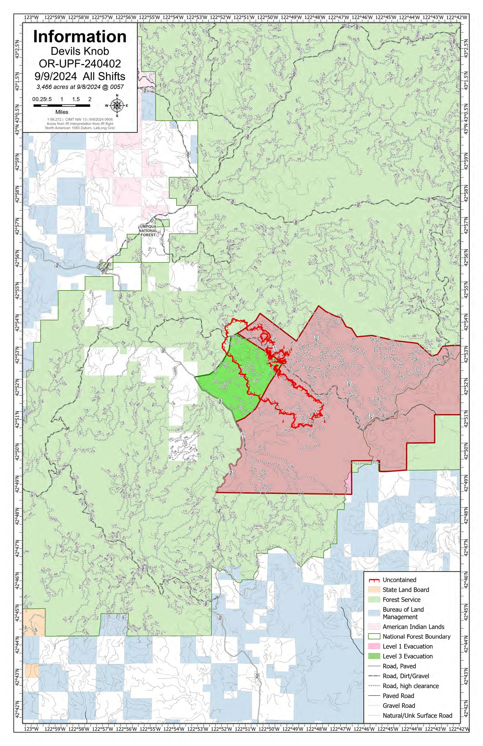
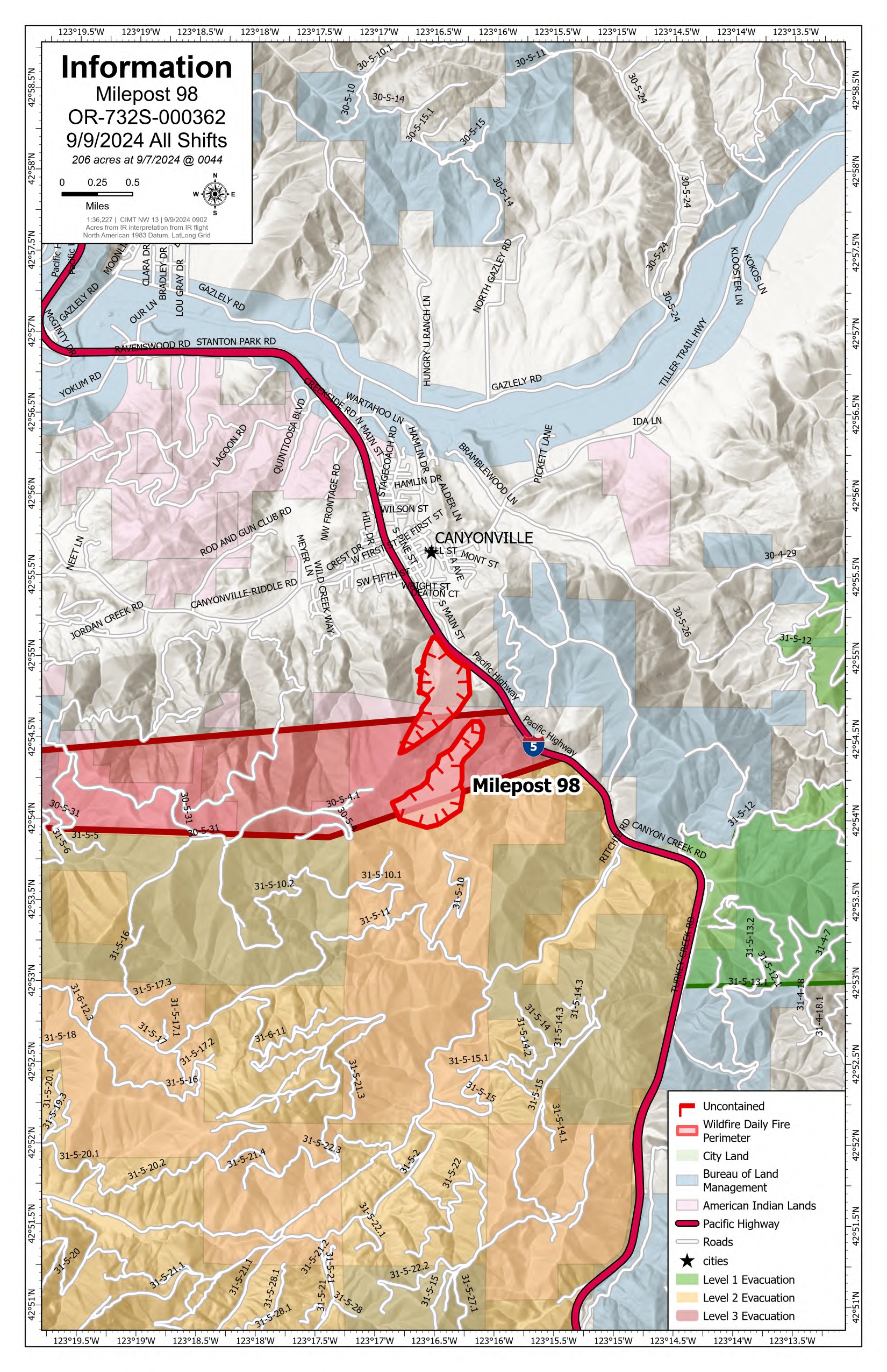
Devils Knob and Milepost 98 Daily Update 09 09 2024
Related Incident:
Publication Type: News
Devil’s Knob and Milepost 98 Fires Update for Monday, September 9, 2024
KEY MESSAGES:
Delays are expected along the Interstate-5 corridor as fire suppression efforts occur on Milepost 98 Fire. For updated travel information, please visit https://www.tripcheck.com/.
CURRENT STATUS:
Local units, including Tiller and Milo Rural Fire Protection District personnel, are working with the CIMT NW 13 to protect structures near the Devil’s Knob and MP98 fire perimeters.
Devil’s Knob
The high heat and low relative humidity led to active burning conditions on the Devil’s Knob Fire. Firefighters are establishing anchor points in which to build hand and dozerline to secure priority areas along the fire perimeter protecting values at risk. A thermal trough is expected tomorrow which will increase fire behavior as heat increases in low elevations.
Milepost 98
Firefighters, working on the spot fire established on Saturday, have successfully built line around its ½ acre perimeter. Resources were engaged in mop-up operations where successful tactical firing operations were completed from previous operational shifts. Firefighters are also plumbing portions of the perimeter to deliver a steady water supply to aid in minimizing the progression of the fire.
WEATHER / FIRE BEHAVIOR:
Mostly sunny skies will continue over the fire area today with a maximum temperature of 83. Relative humidity levels will remain low as the warming and drying trend continues through the day. Wind will be light, with gusts up to 12 miles per hour. This weather pattern may produce fire growth but less rapidly than in previous days.
SAFETY AND CLOSURES:
Closures on the Umpqua National Forest can be found at https://www.fs.usda.gov/alerts/umpqua/alerts-notices. These alerts show the official closure orders with listed roads and trailheads, as well as maps of the closed areas.
Multiple evacuations have been established in the fire area. These evacuations are coordinated by the Douglas County Sheriff’s Office. An interactive map can be found at their website, https://www.dcso.com/EVACUATIONS. Residents are encouraged to sign up for emergency notifications through Douglas County Emergency Management, found at https:// www.dcso.com/254/Emergency-Notification-System. The Red Cross has pre-positioned supplies in Days Creek if a shelter is needed. Staff and volunteers remain available for activation where requested.
Middle Fork Complex Operational Video Update for Monday 09 09 2024
Related Incident:
Publication Type: Announcement
The Middle Fork Complex Fire operational video update for Monday, September 9, 2024 with the Operations Section Chief, Great Basin Incident Management Team 5 can be viewed here: https://youtu.be/1Tf5_ZuGRHY?feature=shared