
Central Idaho Smoke Outlook 091024 09 10 2024
Related Incident:
Publication Type: News
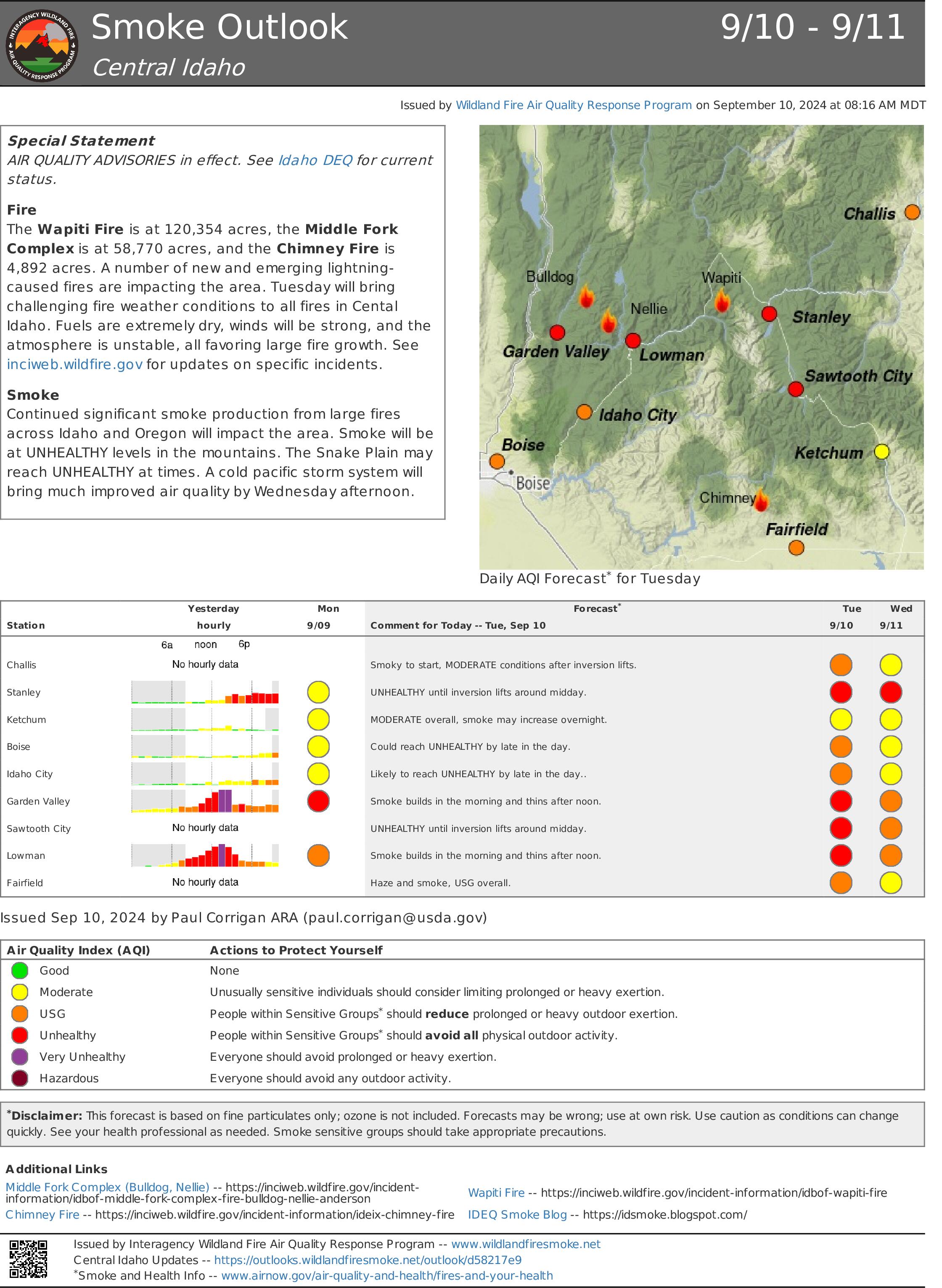
Special Statement
AIR QUALITY ADVISORIES in effect. See Idaho DEQ for current status.
Fire
The Wapiti Fire is at 120,354 acres, the Middle Fork Complex is at 58,770 acres, and the Chimney Fire is 4,892 acres. A number of new and emerging lightning-caused fires are impacting the area. Tuesday will bring challenging fire weather conditions to all fires in Cental Idaho. Fuels are extremely dry, winds will be strong, and the atmosphere is unstable, all favoring large fire growth. See inciweb.wildfire.gov for updates on specific incidents.
Smoke
Continued significant smoke production from large fires across Idaho and Oregon will impact the area. Smoke will be at UNHEALTHY levels in the mountains. The Snake Plain may reach UNHEALTHY at times. A cold pacific storm system will bring much improved air quality by Wednesday afternoon. View interactive smoke outlook.
Lava Fire Update September 10 2024 09 10 2024
Related Incident:
Publication Type: News
OLA, Idaho, September 10, 2024 – Extreme fire behavior continued on the Lava Fire yesterday. The fire is now approximately 69,658 acres and has merged with the Boulder Fire to the east, for a combined acreage of 78,457 acres.
Today, Southern Area Red Team, a Complex Incident Management Team (CIMT), will in-brief with Wyoming Team 6, the type 3 team currently managing the Lava Fire. A CIMT is mobilized during complex emergency incidents to provide command-and-control infrastructure in order to manage the operational, logistical, informational, planning, fiscal, community, political and safety issues associated with complex incidents. Southern Area Red CIMT will take command of the fire on Thursday.
Yesterday, crews worked to slow fire progression towards Indian Valley by constructing fireline and tying it in with dozer line on the south end of the fire. Fireline is handline that firefighters construct by digging down to the bare mineral soil to hold the fire and keep it from growing. Today, crews will work to tie in those lines on the west side of the fire heading north and scout additional areas to put in fireline between Indian Valley and West Mountain. Heavy equipment and aerial resources will continue to support firefighting operations and fire personnel will implement structure protection strategies. The Forest Service uses all available strategies and tools to suppress wildfires, and public and firefighter safety are the top priorities for fire managers.
Beginning tonight, cooler temperatures with showers and thunderstorms are predicted. A strong system will move in Wednesday and Thursday, bringing stronger winds, cooler temperatures and higher relative humidities, a chance for thunderstorms and potentially heavy rain. Fire Weather Watch is in effect for Wednesday afternoon and evening. A Fire Weather Watch is issued when the combination of dry fuels and weather conditions support extreme fire danger.
Gem County Sheriff’s Office issued LEVEL 3 “GO!” Evacuation notices to residents on Third Fork Road, North of Nesbitt Lane, Nesbitt Lane, Second Fork Road (North of Nesbitt Lane), and Sage Hen Reservoir. The Gem County Sheriff’s Office notified the residences in person on September 8th, 2024.
Gem County Road and Bridge issued the following road closures: Third Fork Road at Nesbitt Lane, and Second Fork Road at Nesbitt Lane. The Sweet-Ola Highway has also been closed at the split to Second and Third Fork Roads. Please be advised that the Gem County Sheriff’s Office is staffing the road closure check points.
Adams County Sheriff’s Office issued LEVEL 3 “GO!” Evacuation notices to residents along Little Weiser Road in Indian Valley to the south of Council, ID. Sheriff deputies have made notifications to residents. Council, ID to the south county line, on the east side of Highway 95 are in LEVEL 2 “SET” Evacuation.
Boise National Forest implemented the Lava Fire Area, Road, and Trail Closure for public and firefighter safety. Visit the Forest Alerts and Notices web page for details.
Visit the Lava Fire InciWeb page at https://inciweb.wildfire.gov/incident-information/idbof-lava-fire for more information. For other news, events and information, visit the Boise National Forest website at https://www.fs.usda.gov/boise and follow the Boise on Facebook @BoiseNationalForest.
Fossil Complex Evening Updatge 09 09 2024
Related Incident: Fossil Complex
Publication Type: News
DRY FUELS IGNITE UNDER LIGHT BREEZES ON THE FOSSIL COMPLEX
SPRAY, Ore. – Westerly winds with gusts to 20 mph were enough to fan dry fuels into very active behavior today on the Service Fire. Torching trees and shifting winds sent firebrands skyward, creating numerous spot fires outside of the main fire body for crews to contend with. An active column was visible from the south as the fire rolled to the east, breeching retardant lines and impacting power lines that serve several communities in the area. The Service Fire is expected to double in size by morning to approximately 15,000 acres.
Intensive efforts by crews last night and today have kept the fire east of ORE 19. Local structural fire crews and two OSFM task forces continued to improve structure security and are working along Kinzua Lane on the north and Whitlock Road to the south. The top priority during night shift is the Service Fire. Crews will work to keep the fire east of ORE 19.
Please avoid the unauthorized use of drones. They are hazardous to aircraft and will ground critical aerial operations.
The Two Cabin and Holmes Fires are now in patrol status. Mop up is progressing deep into the interior on the Kinzua and Canyon Fires with excellent progress toward reaching patrol status. As the need for resources on these fires diminishes, they will be shifted to the Service Fire and any other critical areas on the Fossil Complex.
Overnight the winds will start to decrease, however the wind conditions will be critical over the next 24 hours. Beyond 24 hours, cooler fall like conditions with the possibility of wetting rains are expected.
Community Meeting: a community meeting is planned for Wednesday September 11th at the Fossil Elementary School Gymnasium at 6:30 PM. Please use the west entrance.
Evacuations: Level 1, Level 2 and Level 3 evacuation orders remain in place on the Service fire.
https://www.facebook.com/WheelerCountySheriffsOffice/
FIRE AT A GLANCE
Fossil Complex
Total Size: 15,552 acres
Two Cabin-251acres
Canyon-190 acres
Kinzua-96 acres
Holmes-15 acres
Service- 15,000 estimated
Containment: 3%
Cause: Lightning
Current Cost: 4.8 M
All Resources
Hand Crews: 35
Engines: 31
Water Tender: 8
Dozers: 18
Skidders: 5
Skidgen: 3
Excavator: 2
Feller Buncher: 1
Total Resources: 969
Aerial Resources
Type 1: 1
Type 2: 2
Type 3: 3
Evacuations:
Level 1: 14 addresses
Level 2: 15 addresses
Level 3: 20 addresses
https://www.facebook.com/WheelerCountySheriffsOffice/
ODF Incident Commander:
Matt Howard, Incident Management Team 2
EMERGENCY FOREST ORDER NO 0512002409 09 10 2024
Related Incident: Line Fire
Publication Type: Closures
SAN BERNARDINO NATIONAL FOREST
USDA FOREST SERVICE
FOREST ORDER NO. 05-12-00-24-09
LINE FIRE CLOSURE ORDER
Pursuant to 16 U.S.C. § 551 and 36 C.F.R. § 261.50(a) and (b), and to provide for public safety, the following acts are prohibited within the San Bernardino National Forest. This Order is effective from September 9, 2024, at 10:00 PM PST, through November 30, 2024.
1.
Going into or being upon any National Forest System lands within the Line Fire Closure Area, as described in Exhibit B and shown on Exhibit A. 36 C.F.R. § 261.52(e).
2.
Being on any National Forest System Road within the Line Fire Closure Area, as listed in Exhibit C and shown on Exhibit A. 36 C.F.R. § 261.54(e).
3.
Being on any National Forest System Trail within the Line Fire Closure Area, as listed in Exhibit C and shown on Exhibit A. 36 C.F.R. § 261.55(a).
Pursuant to 36 C.F.R. § 261.50(e), the following persons are exempt from this Order:
1.
Persons with Forest Service Permit No. FS-7700-48 (Permit for Use of Roads, Trails, or Areas Restricted by Regulation or Order), specifically exempting them from this Order.
2.
Any Federal, State, or local officer, or member of an organized rescue or fire fighting force in the performance of an official duty.
3.
Owners or lessees of land, to the extent necessary to access their land.
These prohibitions are in addition to the general prohibitions in 36 C.F.R. Part 261, Subpart A.
A violation of these prohibitions is punishable by a fine of not more than $5,000 for an individual or
$10,000 for an organization, or imprisonment for not more than six months, or both. 16 U.S.C. § 551 and 18 U.S.C. §§ 3559, 3571, and 3581.
Executed at San Bernardino, California this 9th day of September 2024.
Bridge Fire Evening Update 090924 09 10 2024
Related Incident: Bridge Fire
Publication Type: News
Bridge Fire Quick Facts:
- Acres: 2,995
- Containment: 0%
- Start Date: September 8, 2024, at 2:40 p.m.
- Cause: Under investigation
- Total Resources: 250
- Crews: 6
- Engines: 22
- Dozers: 2
- Helicopters: 4
- Fixed-wing Aircraft: 4
- Fire Information Center: (626) 662-0120 | Hours: 8:00 a.m. to 8:00 p.m.
Current Situation: Today the Angeles National Forest went into unified command with neighboring agencies, which include the Los Angeles County Fire Department, Los Angeles County Sheriff's Department, and San Bernardino County Fire Department.
Today, firefighters worked with aircraft while constructing fireline by hand and through the use of bulldozers around the fire’s perimeter. This afternoon, the fire activity increased and burned in an easterly direction, creating large smoke columns visible throughout the San Gabriel Valley. The Dalton Hotshots and Texas Canyon Hotshots, with support from helicopters and air tankers, were successful in slowing the fire’s southern progress. The west side of the fire had minimal activity and was held on Shoemaker Road.
Tonight, firefighters will continue constructing fireline by hand and dozer line construction around the fire’s perimeter with support from the Quick Reaction Force night-flying helicopters.
To stay up-to-date with current wildfire information, follow the Angeles National Forest:
- InciWeb: https://inciweb.wildfire.gov/incident-information/caanf-bridge-fire
- Facebook: https://www.facebook.com/angelesnationalforest
- X (formally known as Twitter): https://x.com/Angeles_NF
- Website: fs.usda.gov/angeles
Evacuations:
- East Fork communities of Camp Williams Resort (café, mobile home park, campground) and River Community (near the resort).
Evacuation Center (American Red Cross)
For more information, call 1-800-733-2767 | Hours: 24-hours
Location: Hacienda Heights Community Center, 1234 Valencia Ave., Hacienda Heights, CA 91745 - Mt. Baldy Road, an evacuation order is in effect for all residents north of the San Antonio Dam up to the Mt. Baldy Resort. Please use Mt. Baldy Road to depart the area.
- Evacuation Center: Jessie Turner Health and Fitness Community Center
909 854-5100 | Hours: 24-hours
Location: 15556 Summit Ave, Fontana, CA 92336
Closures:
- San Gabriel Canyon and the East Fork of the San Gabriel River remain closed to all forest visitors.
- Highway 39
- East Fork Road
- Glendora Ridge Road
- Glendora Mountain Road
- Mt. Baldy Road at Shinn Road intersection
Weather and Fire Behavior: The National Weather Service has issued an excessive heat warning until afternoon Wednesday due to hot, dry, and unstable conditions. Gusty onshore winds started today. Low humidity is expected on Tuesday into early Wednesday over the San Gabriel Mountains.
Fire Restrictions:
The current fire danger level on Angeles National Forest is HIGH. "Know Before You Go" – always check fire restrictions before each and every visit, as restrictions can change at any time with little to no notice:
Umpqua National Forest Closures 08 28 2024
Related Incident:
Publication Type: Closures
UNITED STATES DEPARTMENT OF AGRICULTURE FOREST SERVICE UMPQUA National Forest
Roseburg, OR ORDER NO. 06-15-24-07
EMERGENCY FIRE CLOSURE
Pursuant to 16 USC § 551 and 36 CFR § 261.50 (a) and (b), and to provide for public safety, the following acts are prohibited upon the roads, trails, and general forest areas within the Umpqua National Forest as described below and shown in Exhibit A. This Order is effective August 27, 2024 through January 15, 2025, unless rescinded sooner. This order rescinds and supersedes Closure Order No. 06-15-24-06, signed August 8, 2024.
PROHIBITIONS:
1. Being on a road. [36 CFR § 261.54 (e)]
2. Going into or being upon an area closed for the protection of public health and safety. [36 CFR § 261.52 (e)]
3. Being on a trail. [36 CFR § 261.55(a)]
AREA 1 CLOSURE BOUNDARY: The fire closure is described as an area starting at T26S, R01E, Sec. 32 at the intersection of County Rd 249 and Highway 138E, following Highway 138 East to Forest Service Road (FSR) 34, following FSR 34 North to Forest Service Trail (FST) 1414, following FST 1414 East to FSR 4776-075, following FSR 4776-075 South to FSR 4776, following FSR 4776 Southeast to Highway 138, following Highway 138 East to FSR 37, following FSR 37 South to FST 1470, following FST 1470 Northeast to FSR 3703, following FSR 3703 east to FSR 4786, following FS 4786 North to FST 1452, following FST1452 Northeast to FST 1452A, following FST 1452A North to FSR 4790-400, following FSR 4790-400 North to FSR 4790, following FSR 4790 North to Highway 138, following Highway 138 East to FSR 2610, following FSR 2610 North to FSR 2612, following FSR 2612 East to FSR 60, following FSR 60 Northeast to the Umpqua NF Boundary, Following the Umpqua NF Boundary Northwest to FSR 22, following FSR 22 Northwest to the Umpqua NF Boundary, following the Umpqua NF Boundary South back to the point of origin.
AREA 2 CLOSURE BOUNDARY: The fire closure is described as an area starting at T27S, R51/2E, Sec. 29 at the intersection of FST 1448 and Highway 138, following FST 1448 East to FST 2000, following FST 2000 South to the unnamed creek in T28S R51/2E, Sec. 24, following the unnamed creek West to Highway 138, following Highway 138 North back to the point of origin. FST 2000/Pacific Crest Trail and FST 1448 Howlock Mountain Trail are open.
AREA 3 CLOSURE BOUNDARY: The fire closure is described as an area starting at T28S, R51/2E, Sec. 21 at the intersection of Highway 230 and Highway 138, following Highway 138 South to the Umpqua NF Boundary, following the Umpqua NF Boundary Northwest to Highway 230, following Highway 230 Northeast back to the point of origin.
EXEMPTIONS: Pursuant to 36 CFR § 261.50(e), the following persons are exempt from this order:
1. Persons with Forest Service Permit No. FS-7700-48 (permit for Use of Roads, Trails, or Areas Restricted by Regulation or Order), specifically exempting them from this order.
2. Any Federal, State, or local officer, or member of any organized rescue or fire fighting force in the performance of an official duty.
3. FSR 3401is open from FSR 2610 to FSR 3401-800.
4. FSR 3401-800 is open from FSR 3401 to FSR 3401-840.
5. FSR 3401-840 is open.
6. FST 1468 Lemolo Falls Trail is open.
7. Eagle Rock Campground is open.
8. Boulder Flat Campground is open.
9. Watson Falls Trailhead is open.
10. Clearwater Falls Trail and Campground are open.
11. Whitehorse Falls Trail and Campground are open.
12. Toketee Falls Trail, Toketee Lake Campground, and Toketee Lake Group Camp are open.
13. Lemolo Lake KOA, Poole Creek, East Lemolo, Inlet, and Kelsay Valley Campgrounds are open.
14. FSR 60 is open from the intersection with FSR 2612 to the intersection with FSR 6000-958.
15. Canton Creek Campground is open.
16. FSR 22 is open.
17. Cedar Creek, Lund Park, and Hobo Camp Campgrounds are open.
18. Private property inholdings will remain accessible to legal property owners.
19. The status of roads, lands, and trails not under Umpqua National Forest jurisdiction will be determined by the corresponding agency or government entity. For the status of Highway 138 and Highway 230, please go to tripcheck.com.
20. PacifiCorp employees performing official duties as part of the relevant FERC license are exempt from this closure.
21. Roads Under Willamette National Forest Jurisdiction: FSR 5850-000, FSR 5850-010, FSR 5850-012, FSR 5850-017, FSR 5850-124, FSR 5850-192, FSR 5850-428, FSR 5850-430, FSR 5850-915, and FSR 5850-917 22. Roads Under Bureau of Land Management Jurisdiction: BLM Road 23-1-13.0, BLM Road 25-1E-31.0 23. Roads Under Lane County Jurisdiction: 2470 Road, Road 2473, and Road 2460 These prohibitions are in addition to the general prohibitions in 36 C.F.R. Part 261, Subpart A.
Violations of this prohibition are punishable by a fine of not more than $5,000 for an individual or $10,000 for an organization, or imprisonment for not more than 6 months, or both (16 U.S.C. § 551; 18 U.S.C. §§ 3351, 3559, 3571, and 3581).
Shoe Fly Fire Evening Update 09 09 2024
Related Incident: Shoe Fly Fire
Publication Type: News
Mop up continues across the Shoe Fly Fire
MITCHELL, Ore. – Firefighters on the Shoe Fly Fire are continuing to push forward on progress across the incident, mopping up around the entire perimeter of the fire and focusing in on one final challenging location. The 24/7 efforts put in by resources, including firefighters, landowners and agencies over the past couple of shifts have paid off and lines have been able to withstand today’s warm and windy conditions.
This afternoon, clearer air allowed for aircraft to fly on the fire, and helicopters assisted resources on the ground with mop-up operations, dropping water on smoldering hot spots. This joint effort helps to speed up the mop-up process and will ultimately add to overall containment on the incident.
The northeast corner remains the last area that is challenging firefighters. Spot fires in timber from a few days ago created pockets of unburned fuel between them. While all of the spot fires are lined, these unburned areas have the potential to carry fire in hot, windy conditions. A number of tactics are under consideration, including strategic firing operations to fill in those gaps or creating additional lines. Resources will determine which path will be most effective out in the field, with temperature, fuels, humidity and topography all taken into consideration tonight.
Evacuation notices for residents around the fire remain unchanged and continue to be evaluated by the Wheeler County Sheriff, Wheeler County Fire Defense Board Chief, and Team 1 Operations personnel. More information on current evacuations is available at https://tinyurl.com/RAPTOR-Evacuation-Info
Structural task forces from Oregon State Fire Marshall are available to return should additional structure protection be needed.
Information for other fires in the area:
Rail Ridge Fire:https://www.facebook.com/profile.php?id=61565474339343
Fossil Complex:https://www.facebook.com/fossilcomplexfire
Wiley Flat Fire:https://www.facebook.com/profile.php?id=61565121969460
Devils Knob and Milepost 98 Evening Update 09 10 2024
Related Incident:
Publication Type: News
Devil’s Knob and Milepost 98 Fires Evening Update for Monday, September 9, 2024
CURRENT STATUS:
Devil’s Knob
The high heat and low relative humidity led to active burning conditions on the Devil’s Knob Fire today. Firefighters were successful today in establishing anchors where hand and dozerline continue to be constructed to secure priority areas along the fire perimeter protecting values at risk.
Milepost 98
Resources were engaged in mop-up operations where successful tactical firing operations were completed from previous operational shifts throughout the day. Firefighters continue to plumb portions of the perimeter to deliver a steady water supply to aid in minimizing the progression of the fire.
ASSIGNED RESOURCES:
Devil’s Knob
Total Personnel: 489
Hand Crews: 13
Engines: 17
Water Tenders: 10
Milepost 98
Total Personnel: 366
Hand Crews: 14
Engines: 11
Water Tenders: 12
EVACUATION INFORMATION:
Devil’s Knob
Level 3- GO NOW for:
Joe Hall, Tison Road, Diamond Elk Roads.
Level 1- BE READY for:
East side of Tiller Trail Hwy 34000 to 36760 block.
Milepost 98
Level 2 - BE SET for:
100 to 7500 block of Ritchie Road to Canyon Creek Road.
Level 1- BE READY for:
100 to 950 block of Canyon Creek Road.
A Level 3 remains in place only for utility structures on upper Ash Creek Road. No residential homes on Ash Creek Rd are included in a Level 3 at this time.
Settings - change map background and toggle additional layers
Filter - control incident types displayed on map.
Zoom to your location
Reset map zoom and position
Could not determine your location.
Show Legend
 Wildfire
 Prescribed Fire
 Burned Area
Response
Burned Area
Response Other
Other
Logan Fire
Unit Information
Incident Contacts
Davis Fire Update 09 09 2024
Related Incident: Davis Fire
Publication Type: News
The Davis Fire is estimated at 5,000 acres, containment remains at 0%. Fourteen structures are currently known to be impacted, and damage assessments will continue in the impacted area of the Davis fire when it is safe to do so. Fire crews continue full suppression efforts, prioritizing the protection of life, property, and critical infrastructure.
Southwest Area Incident Management Team 1, a Complex Incident Management Team, assumed management of the fire at 6 p.m. this evening. Southwest Incident Management Team 1 will be helping increase the management capabilities for this fire while continuing to work with local agencies. A community briefing is being planned for Tuesday, Sept. 10, 7 p.m. at Depoali Middle School, 9300 Wilbur May Parkway, Reno, NV 89521.
Today, Nevada Governor Joe Lombardo visited the fire, thanking firefighters and cooperating agencies for all their hard work and support of the incident. Washoe County Commissioner, Alexis Hill toured the fire area and expressed her gratitude for the fire fighters.
Firefighters’ main objective today is working to keep the Davis Fire south and east of the Mt. Rose Highway. On the northern flank of the fire, crews continue to construct hand line and secure the fire perimeter. On the southern boundary of the fire, crews continue to mop up hotspots and around structures. The west and north flank of the fire remains active, dozers and hand crews are constructing fire line and going direct when possible. Scooper aircraft assisted on the fire today, dropping water in conjunction with hand line and dozer line construction.
A red flag warning for high winds is forecasted for tomorrow, with Wednesday expected to be the strongest prior to passage of a cold front. Smoke will continue to be visible in the Reno area from increased fire activity during high wind events. Check out the Fire and Smoke Map (airnow.gov) for more information on air quality.
In the interest of public and firefighter safety, the Humboldt-Toiyabe National Forest’s Carson Ranger District is asking the public to refrain from recreating in the Mt. Rose corridor from Tahoe Meadows and east towards the fire.
Evacuation areas have not changed and remain in effect. The evacuations currently are north and south of Nevada State Route 431 (Mt. Rose Highway) to include Arrow Creek, Montreux, St. James Village, West Washoe Valley, Galena Terrace, Sky Tavern, Mt. Rose Ski Resort, and Logan Meadows. For more detail evacuation locations visit: www.perimetermap.com or InciWeb. Evacuations levels are being evaluated to determine when and where it is safe to reduce them.
There is an evacuation center is at the Senior Center located at 1155 E 9th Street in Reno, and Washoe County Regional Animal Services has mobile shelters on site for small animals. Large animals can be taken to the University of Reno Equestrian Center in Reno or Fuji Park in Carson City.
Washoe County Animal Control is available recover pets and large animals in the evacuation area by calling 775-322-3647 #1 (8 a.m.-10 p.m.). Dispatch will need the address, description of animal, where it is located on the property, and number of animals.
NV Energy has restored power to several thousand customers. At the peak there were 17,000 customers without power. Currently, there are 3,116 customers without power, which include those who are closest to the fire and where powerline infrastructure has been damaged and is being repaired. To learn more about outage preparation visit: www.nvenergy.com/outages-and-emergencies/outage-preparation-tips.
Old U.S. Highway 395 is open from Mt. Rose Highway to East Lake Boulevard but remains closed from East Lake Boulevard to Bowers Mansion Interchange. U.S. Route 431 (Mt Rose Highway is still closed. For updates on road closures, visit: https://www.nvroads.com/.
Please use caution when traveling in the area as emergency vehicles and fire apparatus are entering and exiting roadways and power outages have impacted some traffic signals.
Truckee Meadows Fire Protection District and the Humboldt-Toiyabe National Forest are currently in unified command in management of the fire, with Southwest Complex Incident Management Team 1 assuming management tonight at 6 p.m. Cooperating agencies assisting in the fire include Reno Fire Department, Sparks Fire Department, Carson City Fire Department, Cal Fire, East Fork Fire Protection District, North Lake Tahoe Fire Protection District, Bureau of Land Management, County Sheriff’s Office, NV Energy and Nevada Division of Transportation.
Starting on Tuesday, Sept. 10, Davis Fire information is now being shared on the following information platforms:
- X: https://x.com/humboldttoiyabe (#DavisFire)
- Facebook: https://www.facebook.com/HumboldtToiyabeNF/ (#DavisFire)
- InciWeb Website: https://inciweb.wildfire.gov/incident-information/nvhtf-davis-fire
- Incident Information: 775-446-5520, Incident Email: 2024.Davis@firenet.gov
Incident Information
- Start: Sept 7, 2024
- Cause: Under Investigation
- Size: 5,000
- Percent Containment: 0%
- Helicopters: 12
- Heavy Equipment/Dozers: 10
- Engines: 58
- Crews: 15
- Total Personnel: 600