
Pedro Mine Fire Update 09 09 2024
Related Incident: Pedro Mine
Publication Type: News
Incident Commander: Chris Hericks
Location: Southwest of Branham Lakes Campground
Start Date: 09/04/2024
Cause: Lightning
Size: estimated at 45 acres
Resources on Site: 3 Initial Attack Modules
Total Personnel: 14
The Pedro Mine Fire, located nine miles east of Sheridan in the Mill Creek area, is burning in steep, rocky terrain with little to no access for firefighters. The area contains a large concentration of standing dead trees (“snags”) that pose challenges to ensuring firefighter safety and in responding to potential medical emergencies, jeopardizing the well-being of firefighters and other responders.
Fire managers from the Forest, working in collaboration with local Madison County officials have identified and prioritized critical values at risk in the fire area. Firefighting efforts will focus available resources on the protection of structures on private inholdings, active mining claims, and Branham Lakes Campground. All these values are approximately .1-.6 miles from the fire.
There are several factors involved in making wildfire management decisions. These factors include, firefighter safety, resource availability and threats to public safety and property. As well as, terrain, fire behavior, fire season outlook and modeling, and past prescribed fire units and vegetation management projects in the area. Fire managers are strategic in their approach and continually reassess conditions and alter management strategies to protect critical values.
CURRENT STATUS/PLANNED ACTIONS:
The fire was relatively calm most of today. A new spot fire has established further to the north, and slightly closer to Lower Branham Lake. Fire managers were focused on point protection for the cabin closest to the fire and operated the sprinkler system today. A helicopter was used for a short time in the morning, and again in the afternoon, to drop water on the fire to slow fire movement into an un-favorable area that would pose a threat to fire personnel and certain values. Barricades were placed at the intersection of Mill Creek Road (FS RD 111) and the Middle Fork Mill Creek Road (FS RD 7313) to limit public access into the fire area and Branham Lakes Campground. As the fire moves north fire personnel continue to assess the other identified values at risk in and around Branham Lakes Campground for protection needs, order the appropriate resources and equipment, and identify timely implementation of the protection measures. One permitted-claim owner arrived to secure belongings from the claim. An overnight mapping mission using infrared has been ordered for tonight.
Tomorrow’s actions will continue with structure protection of the cabin closest to the fire by patrolling for spot fires and operating the sprinkler system. Fire personnel will also assess, and potentially initiate, pro-active burning around Branham Lakes Campground. These actions will reduce the amount of fuel available to burn. Reducing these fuels will help protect the infrastructure and vegetation in the campground, as well as lessen the intensity of a future wildfire and the threat that would pose to recreationists and first responders. The main fire will continue to be monitored for fire spread and threat to identified values.
These actions are designed to allow fire personnel to protect the identified values at risk while operating in areas that have much better access and egress to safety.
Agency representatives continue to compile contact information for affected landowners immediately adjacent to the fire area.
WEATHER AND FIRE BEHAVIOR:
The fire received a very small amount of rain last night. That moisture, combined with the very heavy smoke, helped limit fire activity today. Tomorrow is forecasted for another dry, warm, and windy day. The low-pressure system arriving Wednesday has approximately 0.5” of rain forecasted through Friday, while conditions return to a cooler, more fall-like weather pattern.
CLOSURES AND RESTRICTIONS:
The Forest is in Stage 1 Fire Restrictions. Campfires are allowed only in a permanent metal fire grate/ring provided by the Forest Service in a designated, developed recreation site. Smoking is restricted to vehicles, in buildings, or in an area clear of flammable materials. Devices with an on/off switch that use LPG fuels are allowed in an area clear of flammable materials within 3 feet of the device.
Big Hollow Fire Final Update 09 09 2024
Related Incident:
Publication Type: News
Location: 13 miles west of Grant, MT Start Date: August 23, 2024
Cause: Undetermined, suspected lightning Size: 3450 acres Containment: 100%
This is the final update for the Big Hollow Fire.
CURRENT STATUS:
Fire managers called the Big Hollow fire contained on September 3rd, 2024. The fire has transitioned down to a Type 5 incident command structure and is currently not being actively staffed due to very minimal fire activity and secure containment lines. Firefighters from the Montana DNRC- Dillon Unit will continue to patrol the fire area to monitor for increased fire behavior. The interior pockets of timber far from control lines or features, are expected to continue to smolder where there is residual heat within ground fuels.
CLOSURES
There are no closures in place and firefighters are not currently staffing the area. If recreating in the area we ask the public to exercise caution due to fire weakened trees and pockets of residual heat.
The Temporary Flight Restriction over the area has also been lifted.
To learn more about wildfire in Montana and how you can better prepare you, your family, and your home, visit MTFIREINFO.ORG
Copperfield Fire Daily Update 992024 09 09 2024
Related Incident: Copperfield Fire
Publication Type: News
Chiloquin, Ore. – Crews continued their progress in mop up and building containment. Work around structures continues, bringing the depth to 200 feet around homes and structures. With the difficult terrain on Corbell Butte making for slower work, there is still some heat near the fire lines. The rest of the cool fire line is at 75 to 100 feet deep. With this continued success, containment increased to 77%.
Today’s weather will continue the cooling temperatures, higher relative humidity and lighter winds. These conditions help crews to continue their mop up efforts and push deeper into the black areas around the fire perimeter. With the shifting winds, smoke has moved into the fire area.
Level 1, 2 and 3 evacuations remain around the Copperfield Fire. Evacuation levels are determined by the Klamath County Sheriff's Office in conjunction with fire officials and agency administrators. Current evacuation areas and levels can be found at https://www.klamathcounty.org/300/Emergency-Management.
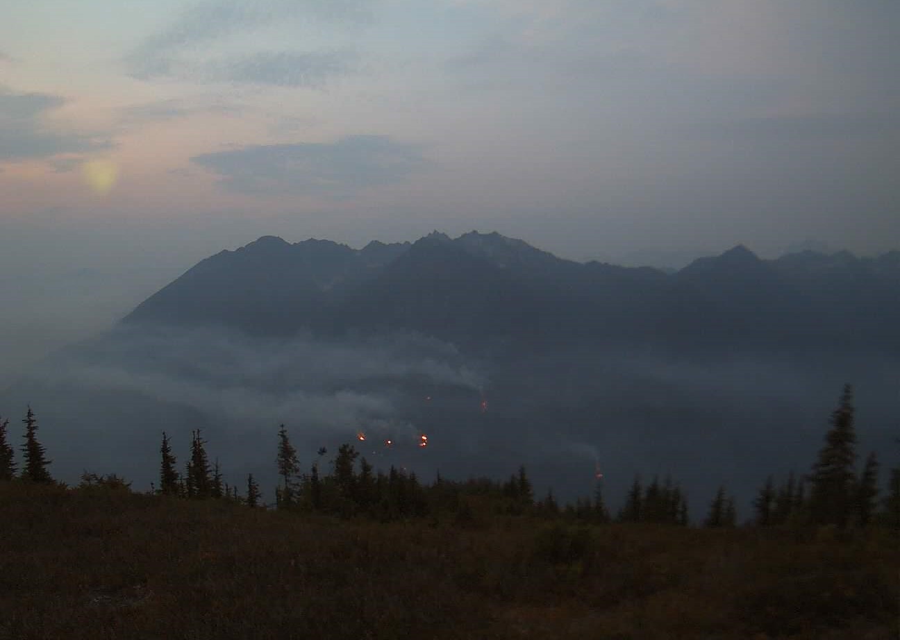
Miners Complex Daily Update 09 09 2024
Related Incident: Miners Complex Fires
Publication Type: Announcement
3:00 PM, September 6, 2024
Estimated size: 1,098 acres
Start Date/Time: July 17, 2024
Area of Origin: 21 air miles east of Darrington WA
Cause: Lightning
Fuels/Topography: timber, rugged terrain
Structures Damaged: None, there are no homes threatened at this time.
Evacuations: None
The Miners Complex consists of eight wildfires caused by lightning strikes in the Mt. Baker-Snoqualmie National Forest. The fires included in the complex are Miners Fire, Vista Ridge Fire, Dolly Creek Fire, Sulphur Three Fire, Sulphur Four Fire, Sulphur Thirty-Four Fire, Plummer, and Middle Ridge Fire.
Update: Increased fire activity occurred Thursday through Saturday as expected, but without significant fire growth. Activity tapered off on Sunday due to haze and smoke sitting in the Suiattle valley. Cooler temperatures will provide relief over the next few days. Firefighter crews continue patrols of the Miners Complex along with accompanying rehab work.
Weather: Marine stratus clouds have made it throughout Puget Sound and into the Cascades. Expect them to linger in the fire area through early this afternoon, around 1 to 2 PM. Winds today will be out of the southwest, but will switch to a northwesterly after 4PM local time today. Low pressure offshore will contribute to a cooler next few days, continued mornings with marine stratus clouds and excellent relative humidity recoveries. They next chance of rain will be Tuesday night into Wednesday as the next frontal system moves in. The high temperature will be around 68°F, with 5-6mph winds becoming west in the afternoon.
Smoke: For more information on smoke and air quality please visit: https://wasmoke.blogspot.com/
Closures: The following is a summary of the areas closed due to the fires in the Miners Complex: Pacific Crest National Scenic Trail #2000.2 from Mica Lake to Suiattle Pass, Suiattle River Trail #784, Miners Ridge Trail #785, Buck Creek Pass Trail #789, Miners Cabin Trail #795, Grassy Point Trail #788, Sulphur Mountain Trail #794, Sulphur Creek Trail #793, Sulphur Creek Campground, Sulphur Creek Trailhead, and the Downey Creek trailhead. Suiattle River Road, closure beginning at Downey Creek trailhead. The full Closure Orders visit: https://www.fs.usda.gov/mbs Forest Restrictions: The Mt. Baker-Snoqualmie has lifted the full campfire ban and forest-wide shooting restrictions, effective 8/28/2024. Additional details at: www.fs.usda.gov/mbs
###
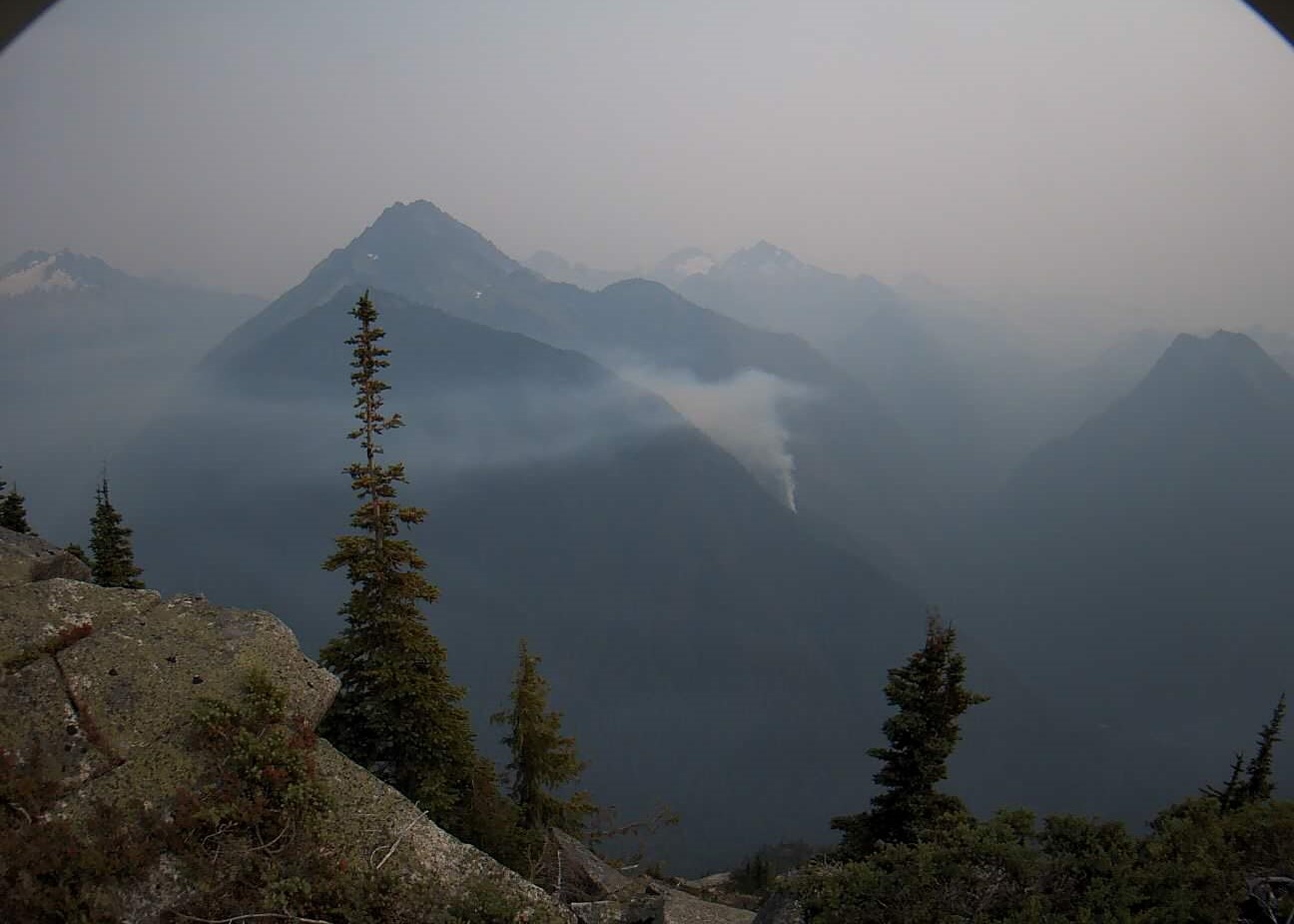
Pincer Two Fire Daily Update 09 09 2024
Related Incident: Pincer Two Fire
Publication Type: Announcement
3:00 PM, September 9, 2024
Estimated size: 211 acres
Start Date/Time: July 17, 2024
Area of Origin: Johannesburg Mountain. 1 Mile East of Mineral Park C.G.
Cause: Lightning
Fuels/Topography: Timber, rugged terrain
Structures Damaged: None, there are no homes threatened at this time.
Evacuations: None
Closures: Cascade River Road at and including Marble Creek Campground, Mineral Park Campground, and all tributary roads, trailheads, and trails are all closed. The public is not to enter the area for public and firefighter safety.
Full closure orders available at: https://www.fs.usda.gov/mbs
Update: Hot and dry temperatures on Thursday and Friday of last week led to increased fire activity as anticipated, and the fire continues to be active on the southeast portion of the fire. Slightly cooler temperatures and haze provided some relief on Saturday and Sunday. The fire is slowly backing down the slope to the 1590 Road. Firefighters will continue to track any rolling debris and hot spots and monitor fire behavior, and cooler temperatures will provide relief over the next few days.
Weather: Marine stratus clouds have made it throughout Puget Sound and into the Cascades. Expect them to linger in the fire area through early this afternoon, around 1 to 2 PM. Winds today will be out of the southwest, but will switch to a northwesterly after 4PM local time today. Low pressure offshore will contribute to a cooler next few days, continued mornings with marine stratus clouds and excellent relative humidity recoveries. They next chance of rain will be Tuesday night into Wednesday as the next frontal system moves in. The high temperature will be around 68°F, with 5-6mph winds becoming west in the afternoon.
Smoke: For more information on smoke and air quality please visit: https://wasmoke.blogspot.com/
Air Space Restrictions: There are no air space restrictions at this time.
Forest Restrictions: The Mt. Baker-Snoqualmie has lifted the full campfire ban and forest-wide shooting restrictions, effective 8/28/2024. Additional details at: www.fs.usda.gov/mbs
###
McDermott Fire Update 09 09 2024
Related Incident: McDermott
Publication Type: News
Incident Commander: David McPhee
Location: 16 miles northwest of Philipsburg, MT
Start Date: 8/26/2024
Cause: Undetermined
Size: 319 acres
Resources on Site: 2 crews; 2 engines; 1 helicopter; miscellaneous heavy equipment
Total Personnel: 59
The McDermott Fire, located in the Upper Willow Creek area, is burning in an inaccessible area containing a large concentration of standing dead trees (“snags”) that pose challenges to ensuring firefighter safety and in responding to potential medical emergencies.
Fire managers from the Forest, working in collaboration with local county officials and cooperating agency representatives, have identified and prioritized critical values at risk in the fire area. The closest values are located three miles to the east of the fire’s location.
Helicopters dropped water on the fire during the initial attack phase, but high winds and the inaccessibility of the fire location resulted in fire growth. Additionally, drift smoke from other large fires to the west and south resulted in the inability to fly additional helicopters for air operations in subsequent days.
CURRENT STATUS/PLANNED ACTIONS:
This incident is being managed by Type 3 Incident Management Team.
The McDermott fire most active on the east and west flanks of the fire. Firefighters are continuing with suppression efforts on the eastern flank of the fire to minimize fire growth towards private property. Aviation support will be limited today based on forecasted winds and low visibility due to hazy conditions.
The widespread haze moved in last night, primarily coming from the southwest. Fires in southern Idaho as well as eastern Oregon have been producing a majority of the smoke.
WEATHER AND FIRE BEHAVIOR:
Today, hot and dry conditions will persist, in addition to wind gusts up to 25 mph. There will be an increase in southwest winds through Tuesday. Temperatures will be in the mid-70s today with relative humidities in the mid-20s. Wednesday a cold front will move through the area, bringing moisture on Thursday. The fire could receive as much as 1 inch of rain.
Fire progression within the last operational period has been on the east and west flanks of the fire. With the increase of gusty winds, fire behavior may increase again today.
CLOSURES AND RESTRICTIONS:
The Forest is in Stage 1 Fire Restrictions. Campfires are allowed only in a permanent metal fire grate/ring provided by the Forest Service in a designated, developed recreation site. Smoking is restricted to vehicles, in buildings, or in an area clear of flammable materials. Devices with an on/off switch that use LPG fuels are allowed in an area clear of flammable materials within 3 feet of the device.
Forest fire managers have closed trails in the area near the fire for public safety.
These trails include the following:
Black Pine Ridge Trail #8006
McDermott Gulch Trail # 8238
Pole Ridge Trail # 8237
Horsetheif Trail # 8297
Schilo Creek Trail # 8240
Upper Will Trail #8106
Rattling Gulch Trail
The public is encouraged to refrain from entering these areas for their safety and to allow for safe and effective
firefighting operations. Heavy equipment, helicopters, and firefighters will be operating near the eastern flank of
the fire and adjacent areas.
Huckleberry Ridge Fire Update 09 09 2024
Related Incident:
Publication Type: News
Huckleberry Ridge Fire
Daily Update
September 9, 2024
Reported: September 4th at 3:45 p.m. | Size: 293 acres | Cause: Under investigation
Total Personnel: 322| Engines/Tenders:28 | Hand Crews: 11
The Huckleberry Ridge Fire continues to burn eight miles from the nearest structure and eleven miles from the nearest community. No infrastructure is at risk at this time.
Update: Crews worked overnight with some slight growth on the east side of the East Fork Chehalis River. Heavy logging slash, thick timber, and very steep terrain continue to challenge operations. However, crews have a great rhythm continuing to add more handlines and dozer lines around the fire perimeter and are transitioning to mop-up operations once solid control points are established. Another hand crew arrived this morning to assist with the good work the team is already doing. Crews will begin laying fire hose along the fire edge to help with cooling the interior edge of the fire as well as any hotspots or stumps still burning. Crews are also working along the 3000-line removing falling debris to help keep the road open for fire traffic use.
Safety: Hunting season continues so please be aware there are both firefighters and hunters in the woods right now. Use caution and stay vigilant. For anyone hunting, please stay out of the fire area and be aware there is substantial firefighting activity in the area with a lot of vehicle traffic.
Evacuations/Closures: There are no anticipated evacuations or road closures in the future for this fire, but we continue to ask that the community stay out of the area of the fire, be alert, and stay aware of the danger that exists in your area.
Weather: Today we are looking at a cloudy high of 72 degrees with some sunshine possibly peeking through. Winds are west-northwest at 5-10 mph. Tonight we are expecting a few clouds with lows of 51 degrees and light variable winds.
Air Space Restrictions: We continue to have a Temporary Flight Restriction (TFR) is in place over the fire. If you fly, we can’t.
Long Tom Fire 09 09 2024
Related Incident:
Publication Type: News
Location: Mount Haggin Wildlife Management Area, 20 miles southwest of Butte, Montana
Start Date: 9/08/2024
Cause: Suspected Lightning; Size: 110 acres
Containment: 0%
Gila County Sheriffs Office Issues SET Status for Geronimo Estates 09 09 2024
Related Incident: 2024 - West Fire - TNF
Publication Type: Announcement
As a result of fire-fighting activity on the West Fire, the Gila County Sheriff's has issued a "SET" status on the Ready, Set, Go model for the following areas due to anticipated fire activity.
- Geronimo Estates
Fire crews will begin fire operations on Monday, September 9th which will be conducted from the top of the Rim down Bray Creek to the Junction of the Control Road (FS64). They will then work west along Control Road toward Hwy 87 over the next few days.
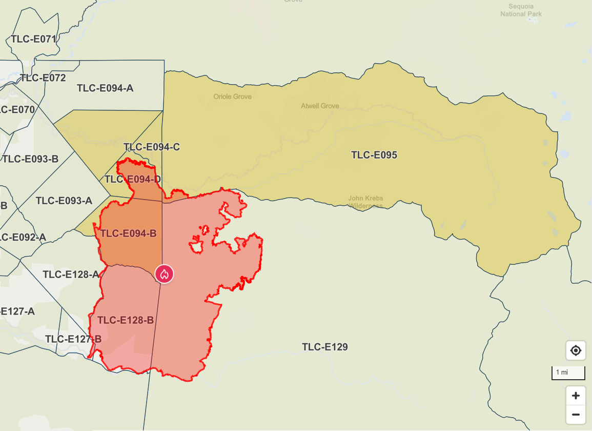
Coffee Pot Fire Evacuation Update 09 09 2024
Related Incident: Coffee Pot Fire
Publication Type: Announcement
Sheriff Lifts Evacuation Warnings, Reduces Orders Due to Coffee Pot Fire
Sheriff Boudreaux has announced the evacuation warnings for the following areas TLC-E128-A, TLC-E093-A and TLC-E093-B, have been LIFTED. The area includes North of South Fork Drive, West of East Fork Kaweah River, East of Salt Creek Road and South of Craig Ranch Road.
Evacuation ORDERS have been reduced to WARNINGS for the following areas: TLC-E094-B, TLC-E094-C, TLC-E094-D and TLC-E094-E. The area includes Case Mountain area, just north of Mineral King Road, East of Oak Grove and West of the Park Boundary line.
Due to fire conditions in the area, there will be road closures along Mineral King Road, between Oak Grove and the National Park Boundary.
For public safety reasons, the access through Mineral King Road may be limited by fire activity, and there may be significant time delays. This will be in effect until further notice and can change at any time.
Please refer to the Genesys website for a more detailed area description: protect.genasys.com.
Residents may now be in this area. However, please be mindful when you are traveling, Fire crews may still be in the area. Please stay clear and out of the areas affected by the fire.
For additional information, please call the Incident Public Information office at 559-492-9988 or refer to https://ow.ly/qmbB50TjjtU.