
Shoe Fly Fire Morning Update 09 09 2024
Related Incident: Shoe Fly Fire
Publication Type: News
Firefighters continue mop up, focus on completing fireline
MITCHELL, Ore. – Overnight firefighters worked to tie together portions of fireline on the southwest corner of the fire near Peggy Butte. Nearly 300 firefighters worked on the fire last night, taking advantage of reduced fire behavior to increase the depth of cold black on the perimeter and improve fireline. The fire grew slightly to 26,475 acres with increased containment of 26%.
Firefighters continue mop up around the fire perimeter, extinguishing hot spots. Gridding along the fire’s edge, they will use tools to dig into areas of thick duff or larger woody material and use water to mix and cool areas of heat or visible flames.
Ruby Fire Update for September 9 2024 09 09 2024
Related Incident: Ruby Fire
Publication Type: News
Ruby Fire Quick Facts
Size: 1217 acres Location: North Cascades National Park, Ruby Mountain, Diablo, Washington
Containment: 0% Cause: Lightning/Natural
Start Date: August 9, 2024 Total Personnel: 54
Fire Information: 360-208-8096
Inciweb: https://inciweb.wildfire.gov/incident-information/wancp-ruby-fire
Email: 2024.Ruby@firenet.gov
Current Status: Yesterday, activity on the Ruby Fire was minimal due to cooler temperatures and lower wind speeds. Three helicopters supported fire suppression efforts by collecting water from Diablo Lake and dropping it over hot spots on the western edge of the fire. Additional growth on the eastern edge was reported. Smoke was present throughout the day. Firefighters are strategically placed around the fire to support suppression efforts if conditions change. Visitors should use extra caution when traveling on State Route 20 (SR20) near Diablo Lake to avoid inhibiting active firefighting operations. Do not stop and take photos until you are in a designated area that is safe to do so. The Thunder Arm portion of Diablo Lake and Colonial Creek South Campground are closed.
Planned Actions: Firefighters will continue to focus on protecting critical infrastructure such as campgrounds, SR20, trails, and backcountry camps in preparation for possible fire growth. The Ruby Fire is a full suppression fire, and firefighters are using tactics with the highest chance for success, while reducing safety risks to firefighters and the public.
Weather: Cool and moist weather over the Ruby Fire is expected through Wednesday with more cloud cover arriving from onshore flow off the Pacific. Today will be partly sunny with a high temperature of 68oF. Winds are expected to be light, west to northwest, with speeds of 6-8 mph.
Closures: There are multiple closures in place for public safety: Colonial Creek South Campground and boat launch, Thunder Arm south of Diablo Lake, Happy Creek Trail, and area trails and camps. See all closures at https://go.nps.gov/fireclosures
Smoke: Air quality is forecast to be GOOD on Monday. Forecast at https://www.airnow.gov
Burning Restrictions: Campfires, the ignition of wood, briquettes, or any fuel in fire pits, fire pans and barbeque grills, are banned in all portions of North Cascades National Park Service Complex: North Cascades National Park, Ross Lake National Recreation Area and Lake Chelan National Recreation Area.
Drone Restrictions: If you fly, we can’t. Drones can jeopardize firefighting efforts, and operating drones within North Cascades National Park is prohibited, except with prior written approval from the superintendent.
Cooperating Agencies & Tribes: National Park Service, Upper Skagit Indian Tribe, Seattle City Light, Whatcom County, Whatcom County Sheriff’s Office, Washington State Dept. of Transportation, Washington DNR.
To sign up for our daily updates, please send an email to: 2024.Ruby@firenet.gov Thank you.
Daily Update for the Chimney Fire 09 09 2024
Related Incident: Chimney Fire
Publication Type: News
Firefighters had a successful day keeping fire within containment lines
Daily Update – Monday, September 9, 2024
Acres: 4,892
Start Date: 9/2/2024
Location: 9 miles northwest of Fairfield, ID
Personnel: 382
Containment: 10%
Fuels: Timber, brush, grass, understory
Highlights: Firefighters are focusing on holding the fire line east of the Middle Fork of Lime Creek and north of the South Fork of Lime Creek today to protect values at risk.
Operations: On Saturday, the fire actively pushed toward Iron Mountain as expected by fire managers. A small spot fire over the northwest flank was identified and the forward rate of spread was stopped. Fire activity may increase this afternoon in response to changing weather conditions. Fire crews are checking and addressing hot spots while patrolling control lines to keep the fire north of the South Fork of Lime Creek and east of the Middle Fork of Lime Creek. Firefighters will continue efforts to keep the fire west of the established heavy equipment lines on the eastern edge to protect range infrastructure and high value timbered areas. A priority focus was established for contingency planning on the southeast corner in anticipation of changing wind direction later this week.
Weather: Today, temperatures will range from 72 to 80 degrees with afternoon humidity back down in the 14-20 percent range. Southwest wind in the afternoon will only gust as high as 22 mph.
Smoke: Smoke may be visible from the Fairfield area, with continuing predicted today. An interactive smoke map located at https://fire.airnow.gov/ allows you to zoom into your area to see the latest conditions.
Closures: The Sawtooth National Forest has issued an emergency temporary closure of trails and trail segments for the Chimney Fire. The purpose of the closure order is for the protection of firefighters and public during wildfire suppression activities occurring in and around the trails. The full closure order (No. 0414-05-065) and map are available on the Sawtooth National Forest website at https://www.fs.usda.gov/alerts/sawtooth/alerts-notices.
Safety: The health and safety of firefighters and the public are always the first priority. A temporary flight restriction (TFR) is in place over the area, which includes uncrewed aircraft or drones. Flying drones near wildfires is dangerous for pilots and firefighters and can bring wildfire suppression efforts to a halt. Know before you fly. If you fly, we can’t. More information can be found at: https://uas.nifc.gov/.
More Information: https://inciweb.wildfire.gov/incident-information/ideix-chimney-fire /
208-246-8292 / https://www.facebook.com/sawtoothnationalforest / 2024.chimney@firenet.gov / https://www.facebook.com/IdahoDepartmentofLands/
Wapiti Fire Update September 9 2024 09 09 2024
Related Incident:
Publication Type: News
Wapiti Fire Statistics:
Size:120,354 acres
Containment: 12%
Total Personnel: 1,473
Location: Grandjean, ID
Reported: July 24, 2024
Cause: lightning
Special Notes: The Custer County Sherriff made a slight reduction in the road closure- State Highway 21 now remains closed east of Lowman to Stanley from MP84 (Sourdough Lodge) to MP126 (Stanley Lake turnoff)due to wildfire activity. Highway 75 remains open.
Current Situation: The fire is being managed under a full suppression values-driven strategy. A values driven suppression strategy emphasizes the protection of values at risk while only placing fire personnel in locations where they will have a reasonable probability of success. Firefighter and public safety remain the highest priority in all management decisions. Resources assigned to the Wapiti Fire are supporting initial attack operations on the Frog Fire on the Sawtooth National Forest and the Lava Fire on the Boise National Forest.
Division DD: The fire in the Sawtooth Wilderness is slowly growing towards the south and east remaining in the drainage bottoms with rocky alpine terrain above it. Minimal resources are staffed in this division due to the limited access within the Wilderness and low fire potential.
Division HH: Contingency lines are complete between Iron Creek and Goat Creek. A structure crew remains in place to provide support as needed.
Division KK and Structure Group East: Excess equipment is being removed from the area and crews have begun to repair the suppression work. Crews continue to mop up and patrol along the entire division. The large spot east of Hwy 21 remains in patrol status.
Divisions PP & MM: Last night crews staffed the burn operations and worked to suppress spot fires that crossed Highway 21. Today they will continue to patrol the area and monitor yesterday’s ignitions. Prep work has been completed at Camp Bradley Scout Reservation and crews remain staged to protect structures if needed. Crews continue to grid for hotspots, mop up, and hold established lines within the Bull Trout Lake area.
Division WW and Structure Group West: Aviation provided multiple drops along north of Highway 21. The structure group is moving further into the Lowman area to assess and prep structures. The fire continues to hold at the Chapman Creek drainage and crews are working to suppress spot fires as they pop up. Personnel remain in the communities to assess structures and be in place to defend structures if needed.
Division VV: Fire in this division is burning partially within the Sawtooth Wilderness and is unstaffed due to the lack of road access.
Weather, Fuels, and Fire Behavior:
The weather will trend hotter and drier on Monday and Tuesday with relative humidities in the range of 10-20%. Critical fire weather is expected on Tuesday due to high temperatures and winds. All fuels are cured and available to burn across all elevations. With proper wind/slope alignment the fire can be expected to make active runs. Starting Wednesday afternoon, a strong change in weather pattern will be present over the fire area. This will bring a storm that is expected to produce up to an inch of rain with winds out of the north and northwest.
Evacuations:
For evacuation information on the Wapiti Fire, please see the Custer County Sheriff’s Facebook page at https://www.facebook.com/p/Custer-County-Sheriff-Idaho-61558947312289/ and the Boise County Sheriff’s Facebook page at https://www.facebook.com/boisecountysheriff/.
To sign up for Custer County CodeRED emergency notifications, text CUSTER to 99411 or enroll online at https://public.coderedweb.com/CNE/BF28E45537FF .
To sign up for Boise County Alert Sense emergency notification enroll online at https://public.alertsense.com/SignUp/publicUser.aspx?regionid=1163
Closures and Fire Restrictions:
State Highway 21 is still closed from MP84 to MP130 for public and firefighter safety.
A Wapiti Fire Area Closure / Forest Order: 0414-04-151 for portions of the Boise, Sawtooth, and Salmon-Challis National Forests can be found at this site: https:/www.fs.usda.gov/alerts/sawtooth/alerts-notices
Boise National Forest Stage 1 Fire Restrictions / Forest Order: 0402-00-63 can be found at this site: https://www.fs.usda.gov/alerts/boise/alerts-notices.
Sawtooth National Forest Stage 1 Fire Restrictions / Forest Order 0414-00-044 can be found at this site: https://www.fs.usda.gov/alerts/sawtooth/alerts-notices
Fire restrictions on federal, state, and private lands may be found at this site: https://www.idl.idaho.gov/fire-management/fire-restrictions-finder/.
A Temporary Flight Restriction is in place over the Wapiti Fire. Wildfires are a no-fly zone for unauthorized aircraft, including drones. If you fly, we can’t. For more information, visit http://knowbeforeyoufly.org.
For More Information:
Information Phone: 208-593-7132
Email: 2024.wapiti@firenet.gov
InciWeb: https://inciweb.wildfire.gov/incident-information/idbof-wapiti-fire
Facebook: https://www.facebook.com/wapitifireinfo2024/
Linktree: https://linktr.ee/WapitiFireInfo2024
Interactive Map: https://tinyurl.com/WapitiFireInfoMap
Fossil Complex Evening Update 09 08 2024
Related Incident: Fossil Complex
Publication Type: News
AERIAL RESOURCES AND GROUND CREWS COMBINE EFFORTS ON THE FOSSIL COMPLEX
SPRAY, Ore. – The Service Fire continues to be the focus of firefighting operations on the Fossil Complex. The weather was favorable for aerial resources to work in tandem with crews on the ground in an attempt to minimize fire spread. The Service Fire lies on the east side of Highway 19, which is closed near Bear Hollow Park between mileposts 65 and 68.
Firefighters anchored a containment line along the southern perimeter of the fire and will advance from there. Along the fire’s active northwest and northeast flanks firefighters held spot fires found yesterday in place with the help of strong aerial support.
The Two Cabin, Kinzua, and Holmes Fires are showing minimal activity as crews finish mop-up operations and move toward patrol status. The Canyon Fire showed some interior torching deep within containment lines. As the need for resources on these fires diminishes, they will be shifted to the Service Fire and any other critical areas on the Fossil Complex.
Thunderstorms moved through the area today, producing about a dozen lighting strikes near the Canyon and Two Cabin Fires, but no wetting rain. A red flag warning remains in effect until 11:00 PM tonight.
Evacuations: Level 1, Level 2 and Level 3 evacuation orders remain in place on the Service fire.
https://www.facebook.com/WheelerCountySheriffsOffice/
Fire Restrictions and Forest Closures
ODF: www.oregon.gov/odf/fire/pages/restrictions.aspx
Umatilla NF: https://www.fs.usda.gov/detail/umatilla/alerts-notices/...
BLM: http://www.blm.gov/.../oregon-washington/fire-restrictions
FIRE AT A GLANCE
Fossil Complex
Total Size: 4,421 acres
Two Cabin-251acres
Canyon-190 acres
Kinzua-96 acres
Holmes-15 acres
Service-3,869acres
Containment: 3%
Cause: Lightning
Current Cost: 2.6M
All Resources
Hand Crews: 25
Engines: 6
Water Tender: 1
Dozers: 3
Skidders: 2
Skidgen: 1
Total Resources: 273
Aerial Resources
Type 1: 1
Type 2: 2
Type 3: 3
Evacuations:
Level 1: 14 addresses
Level 2: 11 addresses
Level 3: 14 addresses
https://www.facebook.com/WheelerCountySheriffsOffice/
ODF Incident Commander:
Matt Howard
Incident Management Team 2
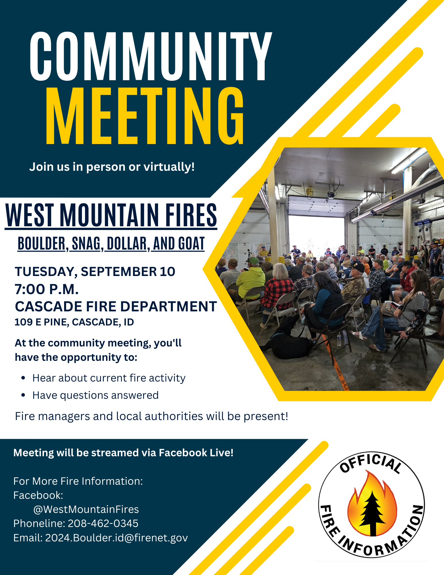
Community Meeting Tuesday Sept 10 at 7pm 09 09 2024
Related Incident: Boulder FireDollar Fire
Publication Type: Announcement
There will be a community meeting on Tuesday, September 10th at 7pm.
Located at the Cascade Fire Department
109 E Pine, Cascade, ID
The meeting will also be streamed on Facebook Live @WestMountainFires on Facebook
Phone line: 208-462-0345
Email: 2024.Boulder.ID@firenet.gov
Lava Fire Evening Update September 8 2024 09 09 2024
Related Incident:
Publication Type: News
OLA, Idaho, September 8, 2024 – Extreme fire behavior resulted in significant and rapid growth in all directions today on the Lava Fire. The fire is now approximately 30,000 acres in size. Firefighting personnel and resources had to evacuate the area this morning due to rapid fire spread. The incident management team and all firefighters have since relocated. All personnel are safe and accounted for.
Damage of structures is being assessed by fire managers and the county sheriff’s office.
Fire managers and personnel are working to develop a structure protection strategy and establish an anchor point from which to build fireline. Fireline is hand or dozer line that firefighters construct by digging down to the bare mineral soil to hold the fire and keep it from growing. Additionally, a Complex Incident Management Team (CIMT) has been ordered and will take command of the fire in the coming days.
Gem County Sheriff’s Office issued LEVEL 3 “GO!” Evacuation notices to residents on Third Fork Road, North of Nesbitt Lane, Nesbitt Lane, Second Fork Road (North of Nesbitt Lane), and Sage Hen Reservoir. The Gem County Sheriff’s Office notified the residences in person on September 8th, 2024.
Gem County Road and Bridge issued the following road closures: Third Fork Road at Nesbitt Lane, and Second Fork Road at Nesbitt Lane. The Sweet-Ola Highway has also been closed at the split to Second and Third Fork Roads. Please be advised that the Gem County Sheriff’s Office is staffing the road closure check points.
Adams County Sheriff’s Office issued LEVEL 3 “GO!” Evacuation notices to residents along Little Weiser Road in Indian Valley to the south of Council, ID. Sheriff deputies have made notifications to residents. Council, ID to the south county line, on the east side of Highway 95 are in LEVEL 2 “SET” Evacuation.
Boise National Forest implemented the Lava Fire Area, Road, and Trail Closure 0402-06-62 for public and firefighter safety. Visit the Forest Alerts and Notices web page for details.
Visit the Lava Fire InciWeb page at https://inciweb.wildfire.gov/incident- information/idbof-lava-fire for more information. For other news, events and information, visit the Boise National Forest website at https://www.fs.usda.gov/boise and follow the Boise on Facebook @BoiseNationalForest.
Shoe Fly Fire Evening Update 09 08 2024
Related Incident: Shoe Fly Fire
Publication Type: News
Mop-up continues across Shoe Fly Fire, firefighters focus on two challenging areas
MITCHELL, Ore. – Firefighters on the Shoe Fly Fire continued to push forward on progress today, mopping up across the majority of the incident and focusing in on two areas that have been challenging.
On the southwest side, firefighters spent today building on direct line against the fire’s edge near Peggy Butte, creating a stronger barrier between the fire itself and unburned fuel outside the perimeter. On the northeast corner, a few small spot fires were found and lined today.
Other than these two areas, which have been the most active portions of the fire, the incident is largely in mop-up status. As mop-up operations continue, containment will steadily increase.
Oregon State Fire Marshal structural task forces continue to work near homes and structures. These resources are mitigating fuel and monitoring fire conditions near structures across the incident. Tonight, one task force will be continuing this work during night shift.
Evacuation notices for residents around the fire remain unchanged and continue to be evaluated by the Wheeler County Sheriff, Wheeler County Fire Defense Board Chief, and Team 1 Operations personnel. More information on current evacuations is available at https://tinyurl.com/RAPTOR-Evacuation-Info
Isolated thunderstorms moved through Central Oregon around noon, bringing windy conditions and very light rounds of showers. ODF Team 1 has resources ready to help the local districts respond to any new reports of fire in the surrounding area.
The weather forecast may shift to being in firefighters’ favor mid-week, when an incoming system is expected to bring lower temperatures and better chances of rain. This moisture would naturally aid in mop-up efforts across the fire.
Rail Ridge Fire Evening Update 09 09 2024
Related Incident:
Publication Type: News
7 p.m. Update- the fire continued to move to the north today east of Battle Creek, and lines are being constructed northeast of its active edge to cut off spread towards Dayville. Additional structure resources were moved into the area, to pre-position in case the fire moves closer to town. Fire conditions calmed in the evening, and the fire stayed well away from Dayville. If conditions permit, it is likely that firefighters will begin burning operations along the ridgeline southwest of Dayville tonight.
This provided an opportunity for structural resources to get more familiar with that area and complete additional structural prep.
The fire was most active on the southeast corner as several spot fires were observed There was one area where fire moved across the line and into the South Fork of the John Day River. It is currently about 10 acres in size. Fire personnel are currently assessing options to get crews in safely to secure perimeter around the spot, but are hampered by the steep, inaccessible terrain. Contingency lines are being built and improved along Indian Creek and farther west if they're unable to hold that line.
The southern and western edges of the fire continue to be improved, with favorable conditions allowing firefighters to fill in unburned areas today to help increase line security.
Davis Fire Afternoon Update 09 08 2024
Related Incident: Davis Fire
Publication Type: News
The Davis Fire is estimated to be approximately 6,500 acres and zero percent contained. The fire started in the area of Davis Creek Regional Park, located in Washoe Valley south of Reno, Nevada, around 2:30 p.m. on Sept. 7, 2024. It is reported to be burning in heavy timber and brush, with medium to long range spotting. Gusty winds are forecasted throughout the week.
Fourteen structures are currently known to be impacted, but damage assessment will continue when it is safe to do so. Fire activity increased with afternoon winds, but fire crews were able to hold the eastern, northern, and southern boundaries. The southern end of the western front experienced the most rapid growth moving to the north and northeast along the Mt. Rose Highway. Fire crews continue full suppression efforts, prioritizing the protection of life, property, and critical infrastructures.
Interstate 580 between Reno and Carson City, Nevada, as well as Old U.S. Highway 395 to Eastlake Boulevard have reopened. Old U.S. Highway 395 is still closed from East Lake Boulevard to Bowers Mansion Interchange. Mt. Rose Highway remains closed. For updates on road closures, visit: https://www.nvroads.com/.
Please use caution when traveling in the area as emergency vehicles and fire apparatus are entering and exiting roadways and power outages have impacted some traffic signals. Some roadways along Mt. Rose Highway and the north side of Washoe Valley remain closed. Please avoid the area for the safety of the fire crews.
Power outages in the south Reno area continue to leave some homes, businesses, and traffic signals without electricity. Customers who are currently without power should be prepared for prolonged outages throughout the incident and those customers living near the fire who still have power should be prepared for potential additional de-energizations due to the dynamic nature of the fire. To learn more about outage preparation visit: www.nvenergy.com/outages-and-emergencies/outage-preparation-tips.
A portion of south Reno remains under evacuation notice, affecting around 12,000 to 14,000 people. Evacuations are in place for Arrow Creek, Sky Tavern, Mt. Rose Ski Resort, and Logan Meadows. For more details on evacuation locations, visit: www.perimetermap.com.
There is an evacuation center set up at the Senior Center located at 1155 E 9th Street in Reno, and Washoe County Regional Animal Services has mobile shelters on site for small animals. Large animals can be taken to the University of Reno Equestrian Center in Reno or Fuji Park in Carson City for those who cannot get to Reno. Several area hotels are offering special rates for evacuees.
Please call ahead to confirm availability and rates:
- The Row, Reno: $59, resort fees waived
- Nugget Casino Resort, Sparks, $100, use code EVAC24
- Best Western on Nugget Avenue, Sparks, $119, pets allowed
Truckee Meadows Fire Protection District and the Humboldt-Toiyabe National Forest are in unified command in management of the fire. The management of the fire will be turned over to the Southwest Area Incident Management Team 1 sometime on Monday, Sept. 9.
Cooperating agencies include Reno Fire Department, Sparks Fire Department, Carson City Fire Department, Cal Fire, East Fork Fire Protection District, North Lake Tahoe Fire Protection District, Nevada Division of Forestry, Bureau of Land Management, Washoe County Sheriff’s Office, Nevada State NV Energy, and Nevada Division of Transportation.
Smoke remains visible in the area. Check out the Fire and Smoke Map (airnow.gov) for more information on air quality. Check out https://inciweb.wildfire.gov/.
- Start: Sept 7, 2024
- Cause: Under Investigation
- Size: 6,500 Acres
- Percent Containment: 0%
- Aircraft: 8
- Heavy Equipment: 15 approx.
- Engines: 57 approx.
- Crews: 14
- Total Personnel: 600 approx.
- X: https://x.com/TMFPD
- Facebook: https://www.facebook.com/TMFPD
- Fire Information: https://inciweb.wildfire.gov/incident-information/nvhtf-davis-fire