
Caldor Fire Update 10242021
Related Incident:
Publication Type: News
10232021 Caldor Fire Update
Related Incident:
Publication Type: News
Quick Facts
Approximate Acreage | 221,835
Containment | 100%
Repair Completed | 55 % Line ; 40% point
Start Date | 8/14/2021
Cause | Under Investigation
Total Personnel | 415
Summary|Weather: With the slight break in the weather, crews are continuing to clean culverts, chip material, and install straw wattles across the fire area. Fire personnel are trying to implement as many measures as possible before the bulk of the storm hits the area tomorrow and Monday. Fire restrictions have been lifted on the Eldorado National Forest (Forest Order 03-21-20).According to Caldor Fire incident weather meteorologist (IMET), Derek Williams, the “atmospheric river” heading for the Sierras is the water equivalent of approximately twelve Mississippi Rivers. Elevations below 7,000 feet may receive five to seven inches of moisture by Monday. Elevations above 7,000 feet could receive several feet of snow. Derek shares a rule of thumb to determine projected snowfall amounts in the Sierras is to multiply rainfall amounts by ten. For example, the five to seven inches of rainfall predicted could equal fifty to seventy inches if it all fell as snow.
The potential for debris flows in the Caldor Fire area are of great concern. Areas of high burn severity within the fire, such as Grizzly Flats and above US 50, could be at the greatest risk for debris flows due to hydrophobic soils. Soils that become hydrophobic repel water, reducing the amount of water infiltration. After a high intensity fire the native plant material can form a waxy substance around soil particles causing the surface layer to repel water. This hydrophobic layer is generally ½ inch to 3 inches beneath the soil surface, according a Natural Resource Conservation Service (NRCS) report. On average the Sierras receive a storm such as this every ten to twenty years. A similar rain event occurred in 2018 within the Thomas Fire burned area in southern California. Heavy rain on freshly burned ground caused devastating debris flows.
The National Weather Service (NWS) has issued a Flash Flood Watch, Flood Watch and a Winter Storm Watch for the area through Monday. Please monitor weather.gov and be alert for possible adverse conditions within the Caldor Fire area.
10222021 Caldor Fire Update
Related Incident:
Publication Type: News
Quick FactsApproximate Acreage | 221,835
Containment | 100%
Repair Completed | 52 % Line ; 40% point
Start Date | 8/14/2021
Cause | Under Investigation
Total Personnel | 526
Summary: Incident management teams work hand in hand with land management agencies to identify areas critical for immediate repair work. As weather moves into the area, crews are focusing repair efforts along the Mormon Emigrant Trail (MET), Capps Creek Road and Plummer’s ridge, removing hazard trees and clearing debris from culverts.
Suppression repair can take on a variety of forms. The following repair tactics are occurring on the Caldor Fire:
- Installing water bars and other drainage diversion to help direct heavy run off events
- Masticating and chipping debris and spreading the resulting slash and mulch to protect bare soils and reduce the potential for erosion and unauthorized travel
- Repairing damaged road drainages (culverts)
- Clearing stream channels and other structures such as culverts from debris to improve water quality
- Removing hazardous trees
- Repairing damages to transportation system roads to ensure public access
Fire suppression repair differs from rehabilitation efforts as it is a series of immediate post-fire actions taken to repair damages and minimize potential soil erosion and impacts resulting from fire suppression activities. It usually begins before the fire is contained, and before the demobilization of an incident management team.
A Burned Area Emergency Response (BAER) team looks more long term. The BAER team has identified and started implementing emergency stabilization actions to reduce post fire threats to life, property, and critical natural and cultural resources. Threats include determining where post-fire rain events could increase runoff and flooding, erosion and sediment delivery, debris flows, and high-risk areas for the spread of invasive weeds. For more information on BAER team action visit: https://inciweb.nwcg.gov/incident/7842/
Weather: A significant weather pattern over the area is expected to bring ample precipitation. The National Weather Service (NWS) has issued Flash Flood, Flood Watch and a Winter Storm Warning for the area. There is a possibility that high elevations could receive up to 36 inches of snow. The public is urged to be careful and consider the weather prior to traveling.

10212021Caldor Fire Update
Related Incident:
Publication Type: News
Caldor Fire Daily Update
Quick Facts
Acreage - 221,835
Containment - 100%
Repair Completed
51% line constructionStart Date - 08/14/2021
40% point
Cause - Under Investigation
Total Personnel - 526
Summary: After burning for over 60 days, the Caldor Fire has reached 100 percent containment. Communities in the Plymouth and South Lake Tahoe area will continue to see firefighters over the next several weeks as focus now turns primarily to repairing the over 400 miles of constructed line and 660 points impacted by suppression effort. “Repair efforts set the immediate stage for our resources and community to recovery from this devastating wildfire,” said Jeff Knudson, Incident Commander.
Caldor Fire Daily Update October 20 2021
Related Incident:
Publication Type: News
Quick Facts:
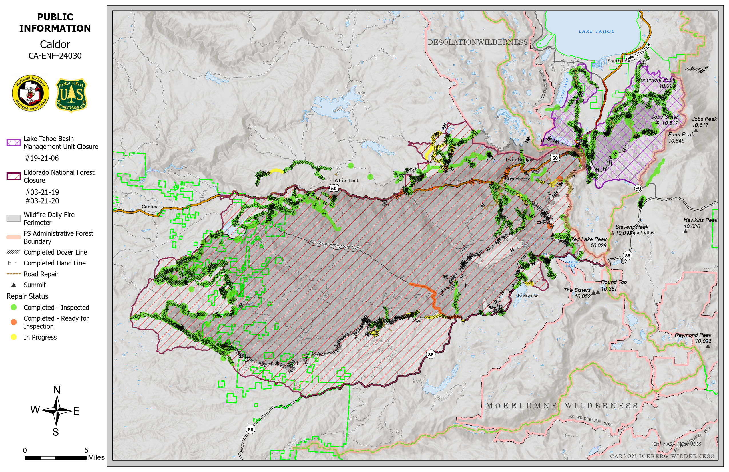
Approximate Acreage | 221,835
Containment | 98%
Repair Completed | 49% line and 38% isolated areas
Start Date | 08/14/2021
Cause | Under Investigation
Total Personnel | 586
Summary: Warmer temperatures allowed resources to capitalize working within a good weather window. Significant weather events are predicted to start arriving today and throughout the weekend as a series of storms pass through the area. These events are expected to produce several inches of rain and snow at higher elevation. “The rain will be welcome across the area as much of northern and central California remains in extreme to exceptional drought.” said Derek Williams, Incident Meteorologist.Both the Eldorado National Forest and Lake Tahoe Basin Management Unit continue to evaluate when, where, and how suppression repair can be completed. The Burned Area Emergency Response (BAER) team is already engaged implementing road and trail stabilization projects. A special emphasis is given to possible affects to infrastructure, watersheds and water quality.Although the fire is almost fully contained, resources are actively monitoring the potential impacts of precipitation. The snow level may drop to 6000 feet making some of the fire area inaccessible. Weather already prevented one repair group from continuing operations. This group was reassigned to another portion of the fire. Shifting resources maximizes the overall effectiveness of operations and balances both long and short-term priorities.
Weather|Anticipated Fire Behavior: An active weather front starting today is expected to bring light showers and up to .4 inches of rain. Another front is expected over the weekend with snow levels down to 6000 feet on Sunday. Fire behavior analysts do not expect any fire spread potential over the next few days.
Planned Actions: The associated precipitation over the next few days will challenge repair efforts. Fire operations will carefully monitor the situation and limit resources in areas where road conditions make engagement unsafe.