An official website of the United States government
Here's how you know
The .gov means it’s official.
Federal government websites often end in .gov or .mil. Before sharing sensitive information, make sure you’re on a federal government site.
The site is secure.
The https:// ensures that you are connecting to the official website and that any information you provide is encrypted and transmitted securely.
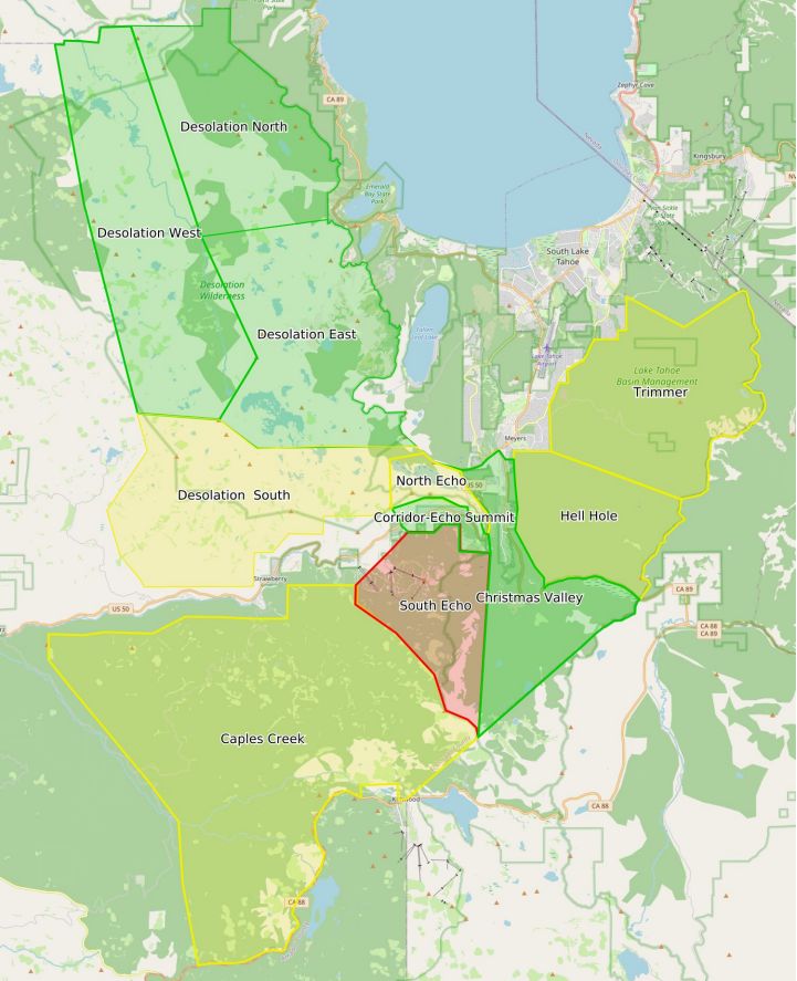
a. The Eldorado National Forest has a new Fire Closure Order and additional restrictions in effect listed below: i. The Caldor Fire Closure, Forest Order 03-21-18 will be in effect until March 31, 2022, but could be lifted sooner or modified if conditions warrant. ii. Due to the continued level of fire risk, the portions of the forest outside the Caldor Fire Closure will be open for day use only. Beginning September 30, overnight camping will be temporarily prohibited under Forest Order 03-21-16 and iii. a full fire ban will be in effect under Forest Order 03-21-17. These restrictions mean that all kinds of open flame are prohibited in the forest, including wood, charcoal, and gas fires. b. The Lake Tahoe Basin Management Unit has two closure orders in effect that close the areas listed specifically within the order: i. Backcountry Closure Forest Order (19-21-07) is in effect for the following areas: Desolation Wilderness, Meiss Country, Barker Pass, Blackwood Canyon and McKinney/Rubicon and is in effect through October 20, 2021. View the closure order and map at https://go.usa.gov/xM9J5. ii. Caldor Fire Emergency Closure (19-21-06) is in effect through December 31, 2021. View the closure order and map at https://go.usa.gov/xM9Jy.1. These orders will be refined over time. 2. Is hunting allowed? a. Yes, hunting is allowed in areas not closed due to the Caldor Fire, and for day use only. (see orders above) 3. Are there still evacuations in place? a. Yes, both evacuation orders and warning remain in place for: i. AMADOR COUNTY – WARNING1. ZONE 4A – South of Highway 88 along the Amador/El Dorado County Line from Dufrene Road, north of the line due East from Dufrene Road to the Amador/Alpine County Line, west of the line due south from Highway 88 to the east end of Salt Springs Reservoir. 2. ZONE 5A – South of Highway 88 along the Amador/El Dorado County Line, north of the line due east from Dufrene Road to the Amador/ Alpine County Line, east of the line due south from Highway 88 to the east end of Salt Springs Reservoir, west of the Amador/Alpine County Line. ii. EL DORADO COUNTY - WARNINGS1. HEAVENLY – East of Pioneer Trail between Larch and Al Tahoe, to include the area of Heavenly Ski Resort out to the Alpine County Line and the Nevada State line on the east. 2. MET TO HWY 88 – South of Mormon Emigrant Trail to Highway 88. Weston Highway88 to Hams Station. 3. US 50 SOUTH TO KYBURZ – South of Highway 50 from Ice House Road to Silver Fork Road, to include the community of Kyburz, excluding the area south of the south fork of the American River. East of Mormon Emigrant Trail to Hwy 88. 4. CRYSTAL BASIN B – From Ice House Road east to the border of desolation wilderness and from the Placer County line, south to Granite Springs Road and the area south of Granite Springs Road to Highway 50 at Wrights Lake Road 5. SLY TO 36 MILESTONECAPLES CREEK – This section is south of Highway 50 east of Kyburz up to 41 Milestone Tract and south all the way to Highway 88 between 1 mile east of Mormon Emigrant Trail up to Caples Lake following the County Line. 6. DESOLATION SOUTH – Please refer to the following map: Eldorado Evacuation Updates 7. HELL HOLE – Northeast of Highway 89, west of the Alpine County line, and south of Tahoe Paradise Golf Course 8. SOUTH ECHO – South of Highway 50 starting at Camp Sacramento to the top of Echo Summit then proceeding due south to the Alpine County Line. 9. TRIMMER – The area east of Pioneer Trail to the Alpine County Line stopping south of Heavenly Ski Resort, excluding all residences off Pioneer Trail. iii. ALPINE EVACUATION – WARNINGS 1. ZONE 21A – Highway 89 at Pickett’s Junction west to the Alpine/El Dorado County Line 2. ZONE 22A – Pickett’s Junction Northeast to Fay Luther Canyon a. Horse Thief Canyon to Fay Luther Canyon 4. Where is the fire most active and what is the containment? a. The fire has not grown in many days. Priorities remain mopping up and securing control line in the Caples Creek and Strawberry Lake drainages in Division Quebec and patrolling highways 50 and 88. Current acreage is 91% contained. 5. Can I access my Special Use Recreation Cabin? a. Recreation cabin owners can obtain a permit by calling their forest service office to access their permitted cabin. The FS-7700-48 exemption permits issued to all recreation residence tracts on the Placerville RD: They are good through October 31, 2021 and being honored them under the 9/30/2021 Caldor Fire Closure Order. 6. When did the fire start? a. This fire was reported on August 14,2021 two miles East of Omo Ranch, and four miles South of Grizzly Flat. 7. What started the fire? a. There is still an investigation being conducted on the cause of this fire.
