
Bachelor Complex Flat Top and Firestone Fires Update 09 20 2024
Related Incident: Bachelor Complex FiresFlat Top and Firestone Fires
Publication Type: News
Northwest 3 Complex Incident Management Team
Lonnie Click ~ Incident Commander
September 20, 2024
Bachelor Complex, Flat Top and Firestone Fires Update
September 20, 2024
Quick Facts: Bachelor Complex
Size: 11,578 acres
Start Date: Sept 8, 2024
Location: 20 miles SW Bend, OR
Personnel: 458
Containment: 37%
Quick Facts: Firestone & Flat Top Fires
Start Date: Sept 6, 2024
Location: North of Fort Rock, OR
Personnel: 215
Firestone Size: 9,338 acres
Containment: 74%
Flat Top Size: 35,942 acres
Containment: 87%
Community meeting 6:00 p.m. tonight, Friday, September 20, at Three Rivers School cafeteria in Sunriver and online at www.facebook.com/deschutesnationalforest .
Firefighters continued to make progress adding depth to further strengthen control lines. Firefighters capitalized on favorable weather and vegetation moisture levels to implement successful burnout operations utilizing both hand and aerial ignition on Little Lava and Firestone Fires. Helicopters supplied bucket drops of water in support of the burn out operations. Aerial patrol and thermal imaging on the Backside and 911 Fires revealed no concentrations of heat. These fires will continue to be patrolled by air for the next several days. Lucky Butte and 846 Fires have limited fuel availability and are also in patrol status.
The northwest corner of the Flat Top Fire was prepared for strategic burning operations. Crews mopped up and secured fire lines while also completing suppression repair work.
Bachelor Complex: Today on the Little Lava Fire, mop-up will continue in the area of yesterday’s burnout along the southern edge. Suppression repair work is ongoing and firefighters will be mopping up any sources of heat along the established control line on the northern side of the Little Lava Fire.
Flat Top Fire: Hose lays and control lines are in place in preparation for a strategic firing operation on the northwest corner of the Flat Top Fire today, should conditions allow. Patrols, mop-up, brush chipping and suppression repair work are ongoing.
Firestone Fire: Mop-up, patrol, brush chipping and suppression repair work continue.
Weather and Fire Behavior: Elevated, to near critical fire weather is predicted for later today. Firefighters will be alert for winds that may test containment lines. Critically dry air will bring minimum relative humidity down to the mid-teens to low 20s. Increased north to north-westerly flow is expected in the afternoon over both fire areas. Mild and dry conditions continue through the weekend before stronger high pressure brings warmer temperatures early to mid-next week.
Closures: There are two emergency Fire Closure areas on the Deschutes National Forest. To view the updated closure orders and maps, visit: https://www.fs.usda.gov/alerts/deschutes/alerts-notices.
Facebook: https://www.facebook.com/deschutesnationalforest/
InciWeb: https://inciweb.wildfire.gov/incident-information/ordef-bachelor-complex-fires
https://inciweb.wildfire.gov/incident-information/ordef-flat-top-and-firestone-fires
YouTube: https://www.youtube.com/@CentralOregonFireInfo?app=desktop
Fire Information Line: (541) 249-9829, 8:00 a.m. to 8:00 p.m.
Smoke & Air Quality Information: fire.airnow.gov
Buck Creek Fire Update 09 20 2024
Related Incident: Buck Creek Fire
Publication Type: News
(Silver Lake, Ore.) – The Buck Creek Fire started in heavy timber within the Yamsay Mountain Semi-Primitive Area on the Fremont-Winema National Forest, about 13 miles southwest of Silver Lake, Ore. The fire spread north and east into managed timber stands on National Forest lands with brush and grass understory and remains about 11 miles from the community of Silver Lake. As containment increases around the fire perimeter, crews are beginning to collect equipment that is no longer needed on the line. Fire managers ask the public to respect forest closures. Even though crews are making good progress on the Buck Creek Fire, the area remains dangerous due to the effects of the fire and ongoing firefighting activity.
Buck Creek: Yesterday, warmer and drier conditions resulted in a slight increase in fire activity within the fire perimeter. Water tenders and road graders worked to return National Forest roads on the eastern portions of the fire to pre-suppression conditions. Mop up continued. Crews began backhauling hoses, pumps, portable tanks, and remaining flagging. Backhauling is the process of removing firefighting equipment from the fire line and returning it to the supply unit in camp where it is packaged and shipped to a fire cache for refurbishment. Overnight, crews patrolled the perimeter to ensure fire did not cross constructed fire lines. A UAS (an Unstaffed Aerial System or drone) with infrared technology scanned near the containment lines to identify any lingering hot spots.
Today, UAS missions will continue to search for hot spots near established fire line; crews will mop up and patrol to make sure the line stays secure. Equipment operators will work on restoring roads around the fire including Forest Roads 3500 and 3038. Firefighters will continue backhauling efforts. Helicopters remain available to assist on-the-ground crews if needed.
Weather: Today, a dry front will pass to the north of the fire bringing possible northerly wind gusts of up to 15 mph. Conditions will be warmer and drier with temperatures expected to be in the mid-70s and minimum humidity in the high teens.
Safety: Firefighting equipment and personnel are present on local roads. For the safety of firefighters and the public, fire managers ask the public to drive carefully and remain clear of the fire areas. The public also plays an important role in preventing the next wildfire by using caution with all ignition sources. For fire prevention tips, visit: https://keeporegongreen.org.
Closures and Restrictions: Fire danger remains high. Campfire and other restrictions are in place within the Fremont-Winema National Forest. A forest closure order is in effect for the area around the Buck Creek Fire. For the complete order and map as well as more detail on fire restrictions, go to: https://www.fs.usda.gov/fremont-winema. Christmas Valley Airport is being used as the helibase for fire operations and is temporarily closed to general aviation. A temporary flight restriction is in place over the Buck Creek Fire.
Smoke: Smoke from fires around the region may affect air quality. For more information on conditions and strategies on limiting exposure, go to: www.oregonsmoke.org or www.AirNow.gov.
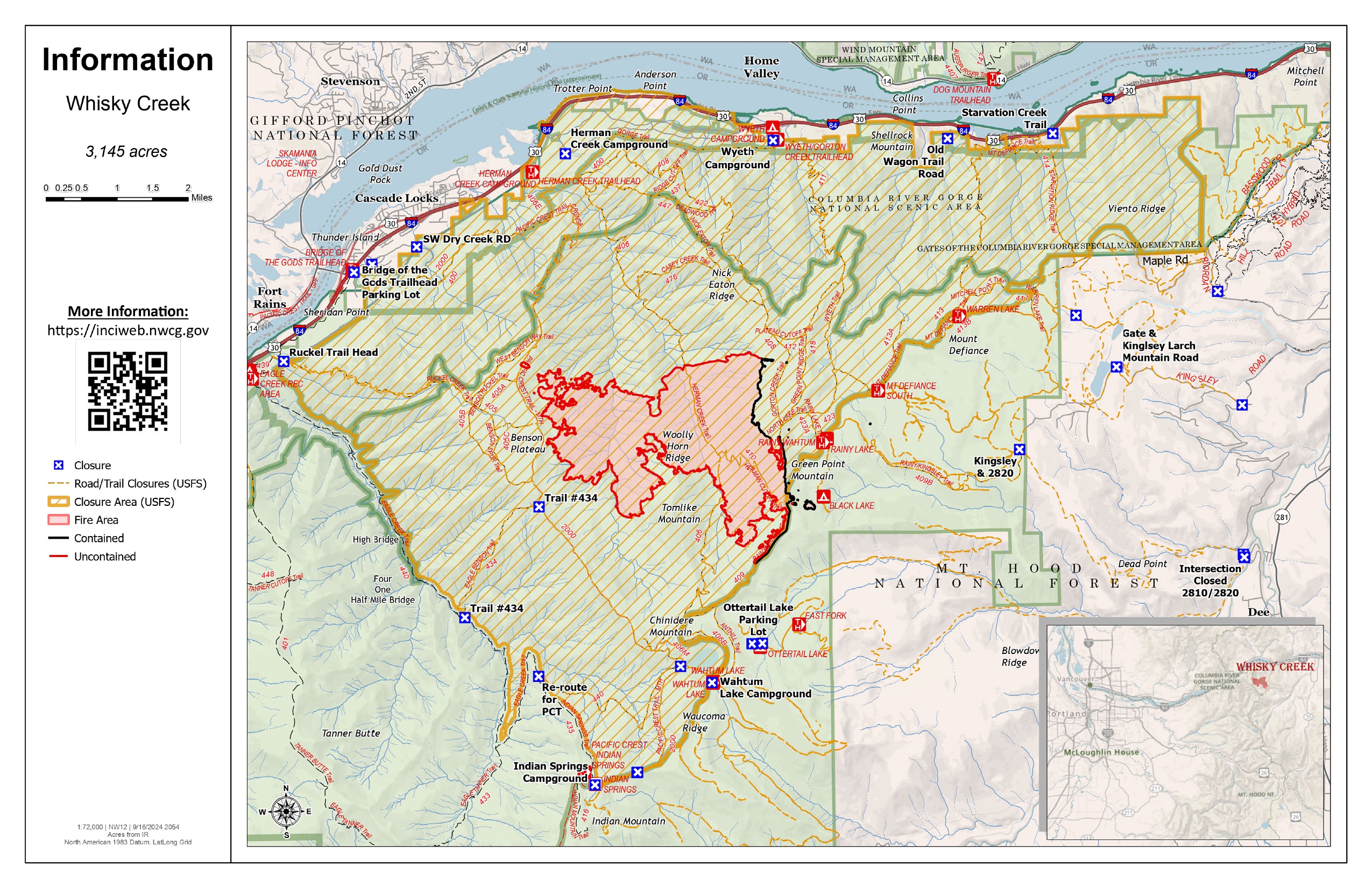
Whisky Creek Fire update 09 20 2024
Related Incident: Whisky Creek Fire
Publication Type: News
Whisky Creek Size: 3,151 acres | Start Date: July 20 | Cause: Human | Containment: 25%
Total Resources: 72 | Hand Crews: 3 | Engines: 3 | Water Tenders: 2 |Heavy Equipment:2
The Whisky Creek Fire is in steep and rugged terrain within the Mark O. Hatfield Wilderness in the Mt. Hood National Forest. The fire remains within the control lines along the southern and eastern edge. The Eagle Creek Fire scar continues to be a barrier along the western and northern edges of the fire.
All fire growth has been along the southern edge of the fire and poses no threat to control lines. The fire is still smoldering in heavy logs and will continue to produce light smoke. Fire behavior is not expected to increase even with sunnier, warmer weather moving into the area.
Yesterday, firefighters were able to completely disassemble and remove the hose lay system along the Rainy Lake and S. Fork Wahtum Lake wilderness boundary trail. This hose system fed the primary handline used for fire suppression. In addition, progress has been made on Forest Road 2820 as crews continue repairing the road’s surface using heavy equipment.
Weather: A ridge of high pressure will continue to build leading to dry conditions. Westerly winds will become more noticeable mostly up near the ridgetops. Humidity recoveries will remain good to excellent. This pattern should continue through Friday and into Saturday.
For smoke forecasts and safety, visit: oregonsmoke.org.
Closures: Area closures remain in the Mt. Hood National Forest, Columbia River Gorge National Scenic Area, and Hood River County. Closures are put into place for the safety of the public and fire crews; intrusion into a closure area can disrupt fire suppression and repair activities, endanger lives and property, and can result in fines. Closure information is at: https://linktr.ee/whisky_creek.2024.
Safety: The public plays an important role in preventing the next wildfire; please use caution with all potential ignition sources. For prevention tips see: https://keeporegongreen.org. The Temporary Flight Restriction remains in effect for the Whisky Fire: https://tinyurl.com/2s49yrj4
Actualizacin diaria del incendio Whisky Creek 09 20 2024
Related Incident: Whisky Creek Fire
Publication Type: News
Tamaño de Whisky Creek: 3,151 acres | Fecha de inicio: 20 de julio |Causa: De orígen humano |Contención 25%
Total de recursos: 72 | Equipos de obreros: 3 | Camiones de bomberos: 3 | Camiones de agua: 2 |Maquinarias pesadas:2
El incendio Whisky Creek se encuentra en un terreno escarpado y escabroso dentro del área de naturaleza Mark O. Hatfield en el Bosque Nacional Mt. Hood. Permanece dentro de las líneas de control a lo largo de los extremos sur y este. La huellas del incendio Eagle Creek continúan como barrera a lo largo de los extremos oeste y norte del incendio.
El crecimiento se ha visto a lo largo del extremo sur del incendio y no representa una amenaza para las líneas de control. Sigue ardiendo entre troncos pesados y continuará produciendo humo ligero. No se espera que empeore la intensidad del fuego aunque el clima en el área se ponga más soleado y cálido.
Ayer, los bomberos pudieron desmantelar y remover por completo el sistema de mangueras a lo largo del sendero fronterizo del área de naturaleza Rainy Lake y S. Fork Wahtum Lake. Este sistema de mangueras alimentaba la línea manual principal que se usó para extinguir el fuego. Además, se ha podido avanzar en el camino forestal 2820, ya que las cuadrillas terminaron de reparar la superficie de la carretera con la maquinaria pesada.
Clima: Continuará formándose una cresta de alta presión, lo que resultará en condiciones secas. Se verán más los vientos del oeste, especialmente cerca de las crestas. Las recuperación de humedad seguirá de buena a excelente. Este patrón debe continuar el viernes y el sábado.
Para saber el pronóstico de humo y seguridad, consulte: oregonsmoke.org.
Cierres: Los cierres de áreas permanecerán en el Bosque Nacional Mt. Hood, el Área Escénica Nacional Columbia River Gorge y el Condado de Hood River. Se establecen cierres para la seguridad del público y de los bomberos; La intrusión en un área de cierre puede interrumpir las actividades de extinción y reparación de incendios, poner en peligro vidas y propiedades, y puede resultar en multas. La información de cierre se encuentra en: https://linktr.ee/whisky_creek.2024.
Seguridad: El público juega un papel importante en la prevención del próximo incendio forestal; tenga cuidado con cualquier posible fuente de incendio. Para obtener consejos de prevención, consulte: https://keeporegongreen.org. La restricción temporal contra vuelos sigue vigente para el incendio Whisky Creek: https://tinyurl.com/2s49yrj4.
Willamette Complex North Fire Update 09 20 2024
Related Incident: North Willamette Complex
Publication Type: News
Willamette Complex North Update Boulder Creek, Ore, Linton Creek, 374 and Pyramid Fires Fire Update for Friday, September 20 through Saturday, September 21, 2024
Fire updates will now be provided for a two-day operational period, with additional information provided commensurate with fire activity on the webpages below.
InciWeb: https://inciweb.wildfire.gov/incident-information/orwif-north-willamette-complex
Willamette Complex North Facebook Page: https://www.facebook.com/profile.php?id=61565845313387
Email: 2024.WillametteComplex.North@firenet.gov
Information line: 541-208-1262 Hours: 8 a.m. to 8 p.m.
Overview: Crews are continuing to work along OR-126 to clear vegetation and debris between mileposts 13 and 19.5 (intersection with OR-242). The work is expected to be concluded Friday evening, at which point, both lanes of OR-126 will be open to through traffic. OR-242 remains closed to all traffic between the intersection with OR-126 and the Dee Wright Observatory (mileposts 55 to 75). For current road conditions, please check Oregon Department of Transportation’s website: https://www.tripcheck.com/.
The firefighting crews appreciate your patience during these travel delays and are working to expedite the return to normal traffic patterns.
A high-pressure system has lowered the humidity levels in the fire areas, impacting the combustibility of the fuels. Incremental temperature increases are forecasted over the next several days but as the days grow shorter, north aspect vegetation is becoming less available to burn. Winds are predicted to remain around 10 mph with daytime winds shifting from east to northwest. Continued warmer and drier conditions will lead to a slight increase in fire behavior but all fires should remain within established containment lines. An increase in visible smoke is possible during warmer daytime temperatures.
Willamette National Forest Area Closures: For public and firefighter safety, fire-related closures remain in place on the McKenzie River Ranger District, as well as on the Middle Fork Ranger District. Please avoid closed areas of the forest. Source: https://www.fs.usda.gov/detail/willamette/alerts-notices/?cid=fseprd552029.
Boulder Creek: 511 acres, 6% contained.
Located 5 miles east of McKenzie Bridge. Crews continue to masticate and chip vegetative material removed from along the fire’s edge on OR-126. Firefighters gained some containment on Thursday, and continue to extinguish areas of heat interior of the containment lines. On the northwest side of the fire, fireline construction continues to prevent fire spread from the steep terrain within Boulder Creek.
Ore: 3,475 acres, 77% contained.
Located 7 miles northeast of Blue River. Crews continue mastication and chipping operations to remove fuels from the edge of the fire area. This fire will continue to be monitored for areas of heat and increased fire activity. Crews are beginning to repair non-essential firelines with tools and equipment.
Pyramid: 1,312 Acres, 98% contained.
East of Middle Santiam Wilderness. Firefighters are removing hose and water pumps, and continuing with chipping and mastication of fuels. Crews are shifting focus to suppression repair of non-primary control lines.
374: 58 acres, 0% contained and Linton Creek: 1,301 acres, 0% contained.
Located in the Three Sisters Wilderness. These fires are remaining within their footprints adjacent to natural barriers and a previous fire scar. While larger material is holding heat and continues to smolder, fire activity remains low. These fires are now in monitoring status.
Fossil Complex Daily Update 9202024 09 20 2024
Related Incident: Fossil Complex
Publication Type: News
Continued Mop Up on Fossil Complex While Suppression Repair Begins
FOSSIL, Ore. – Mop Up continues on the Service Fire in the Fossil Complex. From the southwest to the northwest corner chipping operations are continuing along with back haul of hose and equipment. The northeast side of the fire continues with mop up operations, but some fire activity was observed in the interior, well within the control lines. From the east side down to the south side of the fire crews are gridding the area to identify hot spots, hazard trees and identifying suppression repair needs.
Identification of suppression repair areas is taking place across the entire fire area. This area includes the Fossil Complex, Lonerock Fire, and the Battle Mountain Complex. This work will help the landscape recover and prevent erosion through installing water bars on roads. Repair also includes repairing any fences or other items that were damaged by firefighting efforts. To better coordinate these suppression repair efforts across the three major areas, spike camps will be established in Long Creek and at the Morrow County OHV park to work on the Battle Mountain Complex and Lonerock Fire scar areas.
Today will be sunny and slightly warmer than yesterday. Winds will be stronger over the three fire areas with gusts up to 15 mph. Humidity is lower today with relative humidity in the 20% range. These factors may contribute to increased fire activity with the fire perimeters. Crews and air resources are available to help extinguish any flare ups.
All evacuation levels for the Service Fire have been lifted and all zones have been placed into "Normal" status. The Two Cabin, Holmes, Kinzua and Canyon Fires are all in patrol status.
Videos: Recordings of the Daily Operations Updates and other stories are available at: https://www.youtube.com/@FossilComplex.
Wood Lake Final Fire Update September 20 2024 09 20 2024
Related Incident:
Publication Type: News
Wood Lake Fire Final Update
Date: September 20, 2024 Size: 27 acres Containment: 25%
Cause: Under Investigation-Human Caused*[1] Start Date: September 10, 2024
Fire Information:
Inciweb page: https://inciweb.wildfire.gov/incident-information/mnsuf-wood-lake-fire
Superior NF Facebook: https://www.facebook.com/SuperiorNF
Twitter/X: https://x.com/SuperiorNF
Sign up for Superior NF Fire Information notices and news
This will be the final fire update unless there is a change in fire activity.
Current Status and Resources: Fire activity is minimal; smoldering and creeping in the duff layer. The fire received additional precipitation from last evening’s storm. Fire weakened dead and downed trees are widespread in the fire area, along with burnt standing trees with fire weakened root systems called snags. For safety of firefighters from the snag hazards, firefighters are not mopping up. Aircraft remain available if needed. The National Preparedness Level remains at 5.
Planned Actions: The White Mountain National Forest firefighters continue to monitor the north line of the fire, along with a local incident commander. All perimeter or containment lines are holding.
Closures: On September 17, 2024, the Superior National Forest (NF) adjusted the Emergency Closure Order #09-09-24-07 for the public’s health and safety due to the Wood Lake fire within the vicinity of recreation areas. For current closure information, see the updated Exhibit A-List of Closed Areas and Exhibit B-Closure Map. Superior NF staff will meet next week to discuss the Wood Lake Fire closure.
For the safety of firefighting resources, no drones are allowed near the fire area and are illegal in federally designated wilderness areas.
Weather and Smoke: Today-Partly sunny, high of 71. Light west winds 5-10mph hour in the morning, with gusts to 20mph. Tonight-Mostly clear, low of 48. West winds up to 5mph. Saturday-A slight chance of showers and thunderstorms. High near 77. Light southwest winds from 5-10mph in the morning, with gusts up to 20mph. Chance of precipitation is 20%.
Overall air quality in the Ely area will be GOOD today. Wildfire smoke from Canada is possible in the area. https://www.pca.state.mn.us/air-water-land-climate/air-quality-forecast
Fire Summary: On September 10, 2024, around 11:00 a.m. a fire was detected on an island of Wood Lake, located north of County Road 18, within the Boundary Waters Canoe Area Wilderness (BWCAW) of the Superior National Forest. The fire is located in T64, R10, S26 on National Forest System land. An Emergency Closure Order is in effect for nine locations including BWCAW Entry Point 26-Wood Lake.
[1] *Superior NF law enforcement staff are requesting any information into the start of the fire. Please email the Superior NF Tipline at SM.FS.SUP-tipline@usda.gov, Superior NF Webpage Tipline. Thank you for your assistance.
Homestead Complex and Lane 1 Fire Daily Update 09 20 2024
Related Incident: Lane 1 Fire
Publication Type: News
Email: 2024.homesteadcomplex@firenet.gov
Fire Information Line: 541-208-7100 (Staffed 8 a.m. to 8 p.m.)
Facebook: https://t.ly/mSLvP
Inciweb: https://t.ly/syeHa
September 20, 2024
Firefighters are using direct and indirect tactics to fully suppress eight fires, totaling approximately 35,695 acres. An infrared flight last night detected 13 acres of fire growth across the Homestead Complex, largely in interior islands of unburned vegetation, on the north flank of the Horse Heaven Fire, and on the south flank of the Fuller Lake fire. 765 people are assigned to the Homestead Complex and Lane 1 fires. The Salmon 33 Fire (275 acres), Reynolds Butte Fire (334 acres) and Lost Bucket Fire (34 acres) have all been 100% contained.
Crews are improving containment lines across the fire area by reducing fuels through mastication, chipping wood, and hauling fuels to landings away from the fire. There are still many miles of uncontained fire edge. Firefighters are mopping up, widening and strengthening fire lines by extinguishing hot spots and removing fuels. Two helicopters are supporting firefighters on the ground, dropping buckets of water as needed. Crews are also clearing and repairing roads impacted by the fires and by fire suppression activities. The goal of these fire suppression and repair efforts is to protect the values at risk: communities and infrastructure; private timber lands; and public resources, including recreation opportunities and fish spawning habitat.
On the Horse Heaven Fire (2,741 acres, 56% containment), masticators are working south on the 3829 road with hand crews supporting fuel reduction in areas too steep for machinery. On the north flank, hand crews are addressing hot spots directly at the fire edge. Engines are focused on mopping up in the northeast. Hose lays are in place to supply water to crews. Chippers are working down the 3831 road on the east flank.
On the Fuller Lake (3,690 acres, 0% containment) and Bullpup (535 acres, 7% containment) fires, a chipper and excavator are pulling out and processing larger vegetation at the northwest edge. On the east flank, a masticator is working on the 319 road to prepare for a contingency dozer line. Firefighters are developing direct fire line just north of the wilderness on the east flank, and cold trailing along the 5851 road. Three masticators and a crew are working south from the 436 road to create indirect fire line. An Uncrewed Aerial System (UAS, or drone) is supporting firefighting operations on the east flank of the Fuller Lake fire.
On the No Man Fire (2,090 acres, 44% containment), a hand crew is working in steep areas at the northwest edge. On the north and south flanks, crews are repairing dozer line. Chipping and log-hauling continue on the south flank, with grading on the 3806 and 38 roads. Firefighters will check on hot spots shown on the infrared detection flight from last night.
On the Lane 1 Fire (25,951 acres, 99% containment) crews are cleaning out ditches and chipping on the 2328 road, and removing snags on the north flank of the fire. On the east flank, a large, tracked chipper is working in the Fairview area. Crews are hauling logs in that area and near Bohemia Mine.
Closures and fire restrictions: Two closure orders impact every District of the Umpqua National Forest https://t.ly/Mvn6G. As of today, the forest is in Moderate Fire Danger with no Public Use Restrictions https://t.ly/LI4cd. A Bureau of Land Management (BLM) Roseburg District closure order is in effect for portions of BLM land bordering the Umpqua National Forest closure north of Steamboat https://t.ly/uWX6l. A BLM Northwest Oregon District closure is also in place for an area west of the Lane 1 fire https://t.ly/oW1lG.
Weather: The weather forecast today is similar to yesterday, except that relative humidities will be lower. A warming and drying trend continues this week, reaching into the 80s on Tuesday, with relative humidities dipping to 28 percent. As fuels dry out, the potential for some fire spread and additional smoke increases.
Rail Ridge and Wiley Flat Fire Update 09 20 2024
Related Incident:
Publication Type: News
Rail Ridge and Wiley Flat Fires
September 20, 2024 Update
Central Oregon Wildfire Information: centraloregonfire.org
Rail Ridge Quick Facts:
Acres: 162,345- Containment: 50% - Detection Date: Sept 2, 2024 - Cause: Lightning - Total resources: 1,182 - Crews: 29 - Engines: 64 - Dozers: 17 - Helicopters: 4
Phone: 541-208-7111 - Email: 2024.railridge@firenet.gov
Facebook/Inciweb: https://linktr.ee/RailRidgeFire
Operational Update
Alaska Incident Management Team 3 assumed command of the Rail Ridge Fire at 6:00 AM today. We thank California Team 10 for their hard work and dedication over the last two weeks.
Operations will continue to focus on strengthening existing suppression lines and establishing shaded fuel breaks while reducing fuel loading along potential containment features. Firefighters will continue to create containment depth around the perimeter, patrolling for heat sources and implementing suppression repair tactics.
As fire behavior moderates with improved weather conditions, crews on the north and northeastern edges of the fire will move into recovery efforts, including road repair and grading and restoring areas affected by firefighting activities. They will also focus on interior mop up, gridding and cold trailing to eliminate any potential threat to containment.
Wiley Flat Quick Facts:
Acres: 30,186 - Containment: 94.5% - Detection Date: Sept 2, 2024 - Cause: Lightning - Total resources: 190 - Crews: 2 - Engines: 3 - Dozers: 2
Phone: 541-208-7108 - Email: 2024.wileyflat@firenet.gov
Facebook/Inciweb: https://linktr.ee/RailRidgeFire
Operational Update
Alaska Team 3 assumed command of the Wiley Flat Fire at 7:00 PM on September 19th. Suppression repair continues around the fire perimeter as crews monitor for any residual heat. Crews are working to utilize extra care with suppression repair work in sensitive areas.
Closures and Evacuations
Rail Ridge Evacuations: All level 1 and 2 evacuation zones have been lifted for Grant County, and level 3 zones have been downgraded to level 2 “set” status. For Crook and Wheeler counties, all evacuation statuses have been lifted.
Wiley Flat Evacuations: All areas inside the fire perimeter are designated Level 3 Evacuation zones The area encompassing approximately one-half mile from the fire perimeter is designated Level 2 evacuation zone.
For Current Evacuation Levels in all counties, please visit: https://linktr.ee/RailRidgeFire
The Red Cross evacuation shelter is in the Carey Foster Hall at Crook County Fairgrounds SE Lynn Blvd. Prineville, OR 97754. Information number: 1-800-RED-CROSS
Closures: The U.S. Forest Service and Bureau of Land Management have implemented closures in the area of the Rail Ridge and Wiley Flat Fires. For more details and closure maps, visit https://linktr.ee/RailRidgeFire
#RailRidgeFire2024 #WileyFlatFire2024 #FireYear2024
Bridge Fire Morning Update 09 20 2024
Related Incident: Bridge Fire
Publication Type: News
Unified Command: CIIMT5, Los Angeles County Fire, Los Angeles County Sheriff, San Bernardino County Sheriff, CAL FIRE – San Bernardino/Inyo/Mono Unit
Start Date: September 8, 2024, at 2:12 p.m.
Fire Information: (626) 662-0120 ***Original number***
Media Line: (626) 470-1395
Hours: 7:00 a.m. to 9:00 p.m.
Email: 2024.Bridge@firenet.gov
Fire Size: 54,795 acres
Percent Contained: 59%
Personnel: 1,870
Injuries: 5
Structures Damaged: 19
Structures Destroyed: 81
Cause: Under investigation
Location: Sheep Mountain Wilderness, San Gabriel Mountains National Monument
CURRENT SITUATION: Firefighters maintained the day shift’s progress overnight, keeping the fire within its current footprint, securing areas with heat, and strengthening containment lines. The lingering marine layer over portions of the fire aided in humidity recoveries in some areas, keeping fire activity minimal.
Today, crews on the fire's northern edge will focus on increasing mop-up depth and securing the fire edge by going further into the black and extinguishing any heat signatures. Firefighters on the northeast flank will work to contain isolated heat remaining in the area while monitoring and patrolling in recently repopulated areas on the east. Feller crews will continue removing hazard trees to improve safety for the public and firefighters in the Mount Baldy Village and Icehouse area.
On the south flank, crews are continuing to monitor and extinguish any heat sources as they strengthen primary and secondary containment lines to limit the possibility of fire spread, while also mopping up in the area surrounding Tanbark.
Crews on the west side will work to limit fire spread by constructing indirect containment line from Rattlesnake Peak north and Mount Baden Powell south, tying into Mount Hawkins. At the same time, additional crews will continue mitigating isolated heat from East Fork Road to Rattlesnake Peak.
Damage inspection teams continued to update interactive maps for residents affected by the Bridge Fire.
For San Bernardino County: prepare.sbcounty.gov/bridge-fire/
For Los Angeles County: recovery.lacounty.gov/bridgefire/
Local Assistance Centers:
Los Angeles and San Bernardino Counties are working together to provide assistance to residents affected by the recent Bridge and Line Fires. The purpose of these LACs is to provide a one-stop center where individuals, family members, and business owners may obtain information on services and assistance needed because of a disaster or damage to personal property. Informational hours for interested members of the public are scheduled as follows:
September 20, 2024
10 a.m. – 8 p.m.
LA County Fairplex
1101 W. McKinley Avenue
Pomona, CA 91768
Expo Hall 8 – Enter Gate 3
September 21, 2024
10a.m. – 8p.m.
The Way World Outreach
Hallmark Campus
4680 Hallmark Parkway
San Bernardino, CA 92407
September 23, 2024
10a.m. – 8p.m.
The Way World Outreach
Hallmark Campus
4680 Hallmark Parkway
San Bernardino, CA 92407
Evacuation Orders:
- North, Northwest of Mt. Baldy Ski Resort
- Big Pines Canyon Road to the community of Big Pines
- East Fork communities of Camp Williams Resort and River Community
Evacuation Warnings:
- Community of Wrightwood
- Mt. Baldy Village
- Icehouse Canyon Trailhead, north to the Mt. Baldy Ski Resort
- From San Antonio Canyon east to Telegraph Peak
- Shinn Road north to Icehouse Canyon is open to residents only
For interactive maps on evacuations:
- Los Angeles County: Genasys Protect website or download the app. https://protect.genasys.com
- San Bernardino: https://sbcounty.maps.arcgis.com
For emergency alerts, please register here:
- Los Angeles County: https://ready.lacounty.gov/emergency-notifications/
- San Bernardino County: https://wp.sbcounty.gov/sheriff/alerts/
Evacuation Centers:
- San Bernardino County Fairgrounds: 14800 Seventh Street, Victorville, CA
- Pomona Fairplex: 601 W McKinley Avenue Pomona, CA (Gate 3, corner of McKinley/White)
Animals:
- Devore Animal Shelter: 19777 Shelter Way, San Bernardino, CA. (909) 386-9820. After hours: (800) 472-5609
- San Bernardino County Fairgrounds: 14800 Seventh Street, Victorville, CA
- Palmdale Animal Care Center (Small Animals): 38550 Sierra Hwy, Palmdale, CA
- Lancaster Animal Care Center (Small Animals): 5210 W Ave I, Lancaster, CA
For more information on evacuation centers:
- www.redcross.org/get-help/disaster-relief-and-recovery-services/find-an-open-shelter.html
- https://lacounty.gov/emergency/
ROAD CLOSURES:
- Big Pines Highway
- Big Rock Creek Road
- Largo Vista Road
- Mescal Creek Road
- Panorama Motorway
- SR-39 at the Base of San Gabriel Canyon
- Glendora Mountain Road north of Big Dalton Road
- Mt. Baldy Rd at Shinn Road (open to residents only)
- Mt. Baldy at Ice House Canyon Road
- SR-2 at Flume Canyon Road westbound
WEATHER:
Rain is forecasted today into the late afternoon, with a chance of thunderstorms. The storms are likely to be slow moving with lower wind speeds. Members of the public in and near recently burned areas are asked to be prepared for the possibility of debris flow. Over the coming weekend, a warming and drying trend will begin, reducing relative humidities in the area.